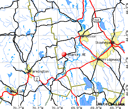
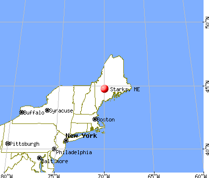
Starks, Maine

Submit your own pictures of this town and show them to the world
- OSM Map
- General Map
- Google Map
- MSN Map
Population change since 2000: +10.7%
 |
| Males: 331 | |
| Females: 309 |
| Median resident age: | 42.1 years |
| Maine median age: | 43.0 years |
Zip codes: 04911.
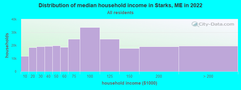
| Starks: | $53,798 |
| ME: | $69,543 |
Estimated per capita income in 2022: $28,916 (it was $13,764 in 2000)
Starks town income, earnings, and wages data
Estimated median house or condo value in 2022: $178,391 (it was $66,900 in 2000)
| Starks: | $178,391 |
| ME: | $290,600 |
Mean prices in 2022: all housing units: $190,782; detached houses: $204,176; townhouses or other attached units: $200,500; in 2-unit structures: $144,246; in 3-to-4-unit structures: $441,593; in 5-or-more-unit structures: $270,949; mobile homes: $101,406; occupied boats, rvs, vans, etc.: $711,279
Detailed information about poverty and poor residents in Starks, ME
Compare current foreclosures near Starks, ME:
| Photo | Address | Area | Beds / Baths | Price | Details |
|---|---|---|---|---|---|

|
#1
Hubbard St
Oakland, ME 04963
|
1,126 sq. feet
|
1 baths 1 beds |
$219,900
|
show details |

|
#2
Shusta Rd
Madison, ME 04950
|
- sq. feet
|
1 baths 3 beds |
$64,900
|
show details |

|
#3
Rice Rips Rd
Oakland, ME 04963
|
- sq. feet
|
- baths - beds |
show details | |

|
#4
Gleason Farm Rd
Oakland, ME 04963
|
- sq. feet
|
- baths - beds |
show details | |

|
#5
Powell Ave Apt 5
Oakland, ME 04963
|
- sq. feet
|
- baths - beds |
show details | |

|
#6
Perham St Apt 13
Farmington, ME 04938
|
- sq. feet
|
- baths - beds |
show details | |

|
#7
New Vineyard Rd
New Vineyard, ME 04956
|
- sq. feet
|
- baths - beds |
show details | |

|
#8
Bennett Ave # 3
Skowhegan, ME 04976
|
- sq. feet
|
- baths - beds |
show details | |

|
#9
Fairbanks Rd
Farmington, ME 04938
|
3,194 sq. feet
|
- baths - beds |
show details | |

|
#10
Chesterville Rd
Jay, ME 04239
|
- sq. feet
|
- baths - beds |
show details |
| Photo | Address | Area | Beds / Baths | Price | Details |
|---|---|---|---|---|---|

|
#11
Axtell Dr
Oakland, ME 04963
|
- sq. feet
|
- baths - beds |
show details | |

|
#12
Hill St
Oakland, ME 04963
|
- sq. feet
|
- baths - beds |
show details | |

|
#13
Nichols St
Madison, ME 04950
|
- sq. feet
|
- baths - beds |
show details | |

|
#14
Bouchard Dr
Belgrade, ME 04917
|
- sq. feet
|
- baths - beds |
show details | |

|
#15
Jesse Ladd Rd
Vienna, ME 04360
|
- sq. feet
|
- baths - beds |
show details | |

|
#16
W Front St
Skowhegan, ME 04976
|
- sq. feet
|
- baths - beds |
show details | |

|
#17
Morgan Ln
Farmington, ME 04938
|
- sq. feet
|
- baths - beds |
show details | |

|
#18
Reed Rd
Madison, ME 04950
|
- sq. feet
|
- baths - beds |
show details | |

|
#19
Sierra Ln
Madison, ME 04950
|
- sq. feet
|
- baths - beds |
show details | |

|
#20
Ward Hill Rd
Norridgewock, ME 04957
|
- sq. feet
|
- baths - beds |
show details |
| Photo | Address | Area | Beds / Baths | Price | Details |
|---|---|---|---|---|---|

|
#21
Main St
Skowhegan, ME 04976
|
- sq. feet
|
- baths - beds |
show details | |

|
Check over 1 million property listings on Foreclosure.com!
|
browse all offers | |||

- 62898.1%White alone
- 50.8%Two or more races
- 40.6%Hispanic
- 20.3%American Indian alone
- 10.2%Asian alone
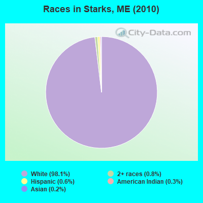
Races in Starks detailed stats: ancestries, foreign born residents, place of birth
 Recent articles from our blog. Our writers, many of them Ph.D. graduates or candidates, create easy-to-read articles on a wide variety of topics.

 | off grid living in maine (39 replies) |
| Maine Population Shifts (44 replies) |
| Is Maine a bunch of libral hippies or conserverative squares? (66 replies) |
| Favorite Maine Festival (12 replies) |
| Maine ranks #2 (29 replies) |
| Where in Maine Would You Live if You Could? (98 replies) |
Latest news from Starks, ME collected exclusively by city-data.com from local newspapers, TV, and radio stations
Ancestries: English (18.7%), Irish (15.7%), French (13.8%), United States (7.6%), German (5.5%), French Canadian (4.8%).
Current Local Time: EST time zone
Incorporated on 02/28/1795
Elevation: 280 feet
Land area: 31.4 square miles.
Population density: 20 people per square mile (very low).
6 residents are foreign born
| This town: | 1.0% |
| Maine: | 2.9% |
| Starks town: | 1.2% ($817) |
| Maine: | 1.5% ($1,417) |
Nearest city with pop. 50,000+: Portland, ME  (75.3 miles , pop. 64,249).
Nearest city with pop. 200,000+: Boston, MA (176.1 miles , pop. 589,141).
Nearest city with pop. 1,000,000+: Bronx, NY (334.5 miles , pop. 1,332,650).
Nearest cities:
), ), ), ), )Latitude: 44.73 N, Longitude: 69.94 W
Area code commonly used in this area: 207

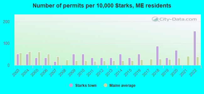
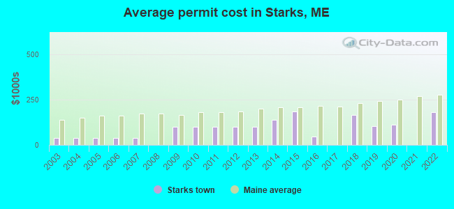
Single-family new house construction building permits:
- 2022: 9 buildings, average cost: $180,000
- 2020: 4 buildings, average cost: $110,000
- 2019: 2 buildings, average cost: $104,000
- 2018: 5 buildings, average cost: $163,600
- 2016: 3 buildings, average cost: $46,700
- 2015: 2 buildings, average cost: $185,300
- 2014: 3 buildings, average cost: $138,800
- 2013: 2 buildings, average cost: $98,200
- 2012: 2 buildings, average cost: $98,200
- 2011: 2 buildings, average cost: $98,200
- 2010: 3 buildings, average cost: $98,200
- 2009: 3 buildings, average cost: $98,200
- 2007: 1 building, cost: $39,000
- 2006: 2 buildings, average cost: $39,000
- 2005: 2 buildings, average cost: $39,000
- 2004: 3 buildings, average cost: $39,000
- 2003: 3 buildings, average cost: $39,000
| Here: | 3.6% |
| Maine: | 3.4% |
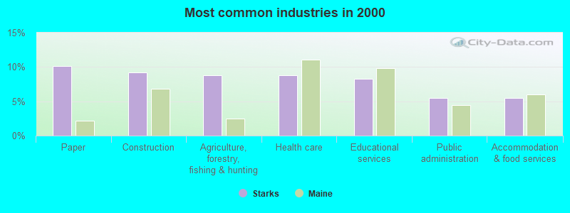
- Paper (10.1%)
- Construction (9.2%)
- Agriculture, forestry, fishing & hunting (8.8%)
- Health care (8.8%)
- Educational services (8.3%)
- Public administration (5.5%)
- Accommodation & food services (5.5%)

- Construction (17.2%)
- Paper (14.7%)
- Agriculture, forestry, fishing & hunting (11.2%)
- Repair & maintenance (6.0%)
- Health care (5.2%)
- Broadcasting & telecommunications (4.3%)
- Public administration (4.3%)

- Educational services (13.9%)
- Health care (12.9%)
- Accommodation & food services (11.9%)
- Public administration (6.9%)
- Agriculture, forestry, fishing & hunting (5.9%)
- Paper (5.0%)
- Retail florists (5.0%)
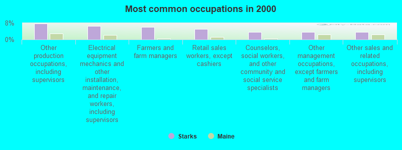
- Other production occupations, including supervisors (7.8%)
- Electrical equipment mechanics and other installation, maintenance, and repair workers, including supervisors (6.5%)
- Farmers and farm managers (6.0%)
- Retail sales workers, except cashiers (5.1%)
- Counselors, social workers, and other community and social service specialists (3.7%)
- Other management occupations, except farmers and farm managers (3.7%)
- Other sales and related occupations, including supervisors (3.7%)
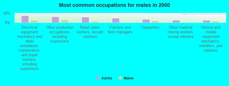
- Electrical equipment mechanics and other installation, maintenance, and repair workers, including supervisors (12.1%)
- Other production occupations, including supervisors (10.3%)
- Retail sales workers, except cashiers (9.5%)
- Farmers and farm managers (7.8%)
- Carpenters (6.0%)
- Other material moving workers, except laborers (4.3%)
- Vehicle and mobile equipment mechanics, installers, and repairers (4.3%)

- Other sales and related occupations, including supervisors (6.9%)
- Textile, apparel, and furnishings workers (6.9%)
- Counselors, social workers, and other community and social service specialists (5.9%)
- Information and record clerks, except customer service representatives (5.9%)
- Other food preparation and serving workers, including supervisors (5.0%)
- Supervisors and other personal care and service workers, except child care workers (5.0%)
- Secretaries and administrative assistants (5.0%)
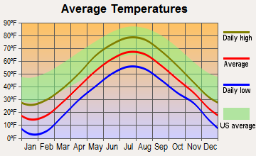
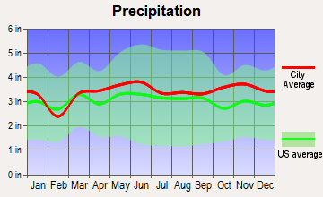
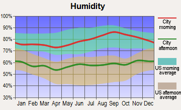
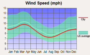
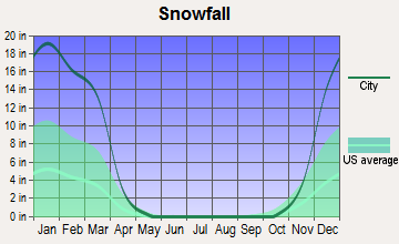
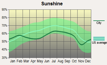
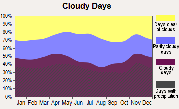
Average climate in Starks, Maine
Based on data reported by over 4,000 weather stations
Earthquake activity:
Starks-area historical earthquake activity is significantly above Maine state average. It is 79% smaller than the overall U.S. average.On 4/20/2002 at 10:50:47, a magnitude 5.3 (5.3 ML, Depth: 3.0 mi, Class: Moderate, Intensity: VI - VII) earthquake occurred 185.5 miles away from the city center
On 4/20/2002 at 10:50:47, a magnitude 5.2 (5.2 MB, 4.2 MS, 5.2 MW, 5.0 MW) earthquake occurred 186.7 miles away from Starks center
On 10/16/2012 at 23:12:25, a magnitude 4.7 (4.7 ML, Depth: 10.0 mi, Class: Light, Intensity: IV - V) earthquake occurred 85.9 miles away from Starks center
On 10/7/1983 at 10:18:46, a magnitude 5.3 (5.1 MB, 5.3 LG, 5.1 ML) earthquake occurred 224.2 miles away from the city center
On 1/19/1982 at 00:14:42, a magnitude 4.7 (4.5 MB, 4.7 MD, 4.5 LG) earthquake occurred 118.4 miles away from the city center
On 2/26/1999 at 03:38:43, a magnitude 3.8 (3.8 LG, Depth: 2.0 mi, Class: Light, Intensity: II - III) earthquake occurred 26.9 miles away from the city center
Magnitude types: regional Lg-wave magnitude (LG), body-wave magnitude (MB), duration magnitude (MD), local magnitude (ML), surface-wave magnitude (MS), moment magnitude (MW)
Natural disasters:
The number of natural disasters in Somerset County (24) is greater than the US average (15).Major Disasters (Presidential) Declared: 16
Emergencies Declared: 7
Causes of natural disasters: Floods: 14, Storms: 13, Snows: 7, Heavy Rains: 2, Hurricanes: 2, Blizzard: 1, Ice Storm: 1, Landslide: 1, Snowfall: 1, Wind: 1, Winter Storm: 1, Other: 1 (Note: some incidents may be assigned to more than one category).
Hospitals and medical centers near Starks:
- MAPLECREST REHAB AND LIVING CENTER (Nursing Home, about 6 miles away; MADISON, ME)
- ORCHARD PARK REHAB AND LIVING (Nursing Home, about 11 miles away; FARMINGTON, ME)
- EDGEWOOD REHAB AND LIVING CTR (Nursing Home, about 11 miles away; FARMINGTON, ME)
- WOODLAWN REHABILITATION AND NURSING CENTER (Nursing Home, about 12 miles away; SKOWHEGAN, ME)
- REDINGTON FAIRVIEW GENERAL HOSPITAL Critical Access Hospitals (about 12 miles away; SKOWHEGAN, ME)
- SANDY RIVER CENTER (Nursing Home, about 14 miles away; FARMINGTON, ME)
Colleges/universities with over 2000 students nearest to Starks:
- University of Maine at Farmington (about 12 miles; Farmington, ME; Full-time enrollment: 2,036)
- University of Maine at Augusta (about 28 miles; Augusta, ME; FT enrollment: 3,204)
- Husson University (about 57 miles; Bangor, ME; FT enrollment: 2,421)
- University of Maine (about 64 miles; Orono, ME; FT enrollment: 8,931)
- Saint Joseph's College of Maine (about 68 miles; Standish, ME; FT enrollment: 2,010)
- University of Southern Maine (about 76 miles; Portland, ME; FT enrollment: 6,647)
- Southern Maine Community College (about 77 miles; South Portland, ME; FT enrollment: 4,666)
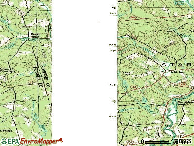
Points of interest:
Notable location: Starks Volunteer Fire Department (A). Display/hide its location on the map
Cemeteries: Greenleaf Cemetery (1), Locke Cemetery (2), Frederic Cemetery (3). Display/hide their locations on the map
Lakes and swamps: Cold Pond (A), Mayhew Bog (B). Display/hide their locations on the map
Streams, rivers, and creeks: Hilton Brook (A), Sandy River (B), Meadow Brook (C), Lemon Stream (D), Falls Brook (E), Josiah Brook (F), Pelton Brook (G). Display/hide their locations on the map
Birthplace of: Edwin F. Ladd - Politician.
Drinking water stations with addresses in Starks and their reported violations in the past:
STARKS WATER DISTRICT (Population served: 55, Groundwater):Past monitoring violations:
- Follow-up Or Routine LCR Tap M/R - In JUL-01-2011, Contaminant: Lead and Copper Rule. Follow-up actions: St Public Notif requested (DEC-08-2011), St Formal NOV issued (DEC-08-2011), St Compliance achieved (JAN-13-2012), St AO (w/o penalty) issued (MAY-16-2012), St BCA signed (JUN-12-2012), St Public Notif received (JUN-25-2012)
- Follow-up Or Routine LCR Tap M/R - In JAN-01-2011, Contaminant: Lead and Copper Rule. Follow-up actions: St Public Notif requested (MAR-03-2011), St Formal NOV issued (MAR-03-2011), St Compliance achieved (JAN-13-2012), St AO (w/o penalty) issued (MAY-16-2012), St Public Notif received (MAY-29-2012), St BCA signed (JUN-12-2012)
- Water Quality Parameter M/R - Between OCT-2009 and DEC-2009, Contaminant: Lead and Copper Rule. Follow-up actions: St Compliance achieved (NOV-22-2011), St AO (w/o penalty) issued (MAY-16-2012), St BCA signed (JUN-12-2012)
- Monitoring and Reporting (DBP) - Between JAN-2008 and DEC-2010, Contaminant: Total Haloacetic Acids (HAA5). Follow-up actions: St Formal NOV issued (NOV-19-2010), St Public Notif requested (NOV-19-2010), St Compliance achieved (DEC-29-2010), St Public Notif received (APR-09-2012), St AO (w/o penalty) issued (MAY-16-2012), St BCA signed (JUN-12-2012)
- Monitoring and Reporting (DBP) - Between JAN-2008 and DEC-2010, Contaminant: TTHM. Follow-up actions: St Formal NOV issued (NOV-19-2010), St Public Notif requested (NOV-19-2010), St Compliance achieved (DEC-29-2010), St Public Notif received (APR-09-2012), St AO (w/o penalty) issued (MAY-16-2012), St BCA signed (JUN-12-2012)
- One routine major monitoring violation
- 3 other older monitoring violations
| This town: | 2.3 people |
| Maine: | 2.3 people |
| This town: | 61.2% |
| Whole state: | 62.9% |
| This town: | 12.5% |
| Whole state: | 9.4% |
Likely homosexual households (counted as self-reported same-sex unmarried-partner households)
- Lesbian couples: 0.4% of all households
- Gay men: 0.7% of all households
| This town: | 16.7% |
| Whole state: | 10.9% |
| This town: | 4.6% |
| Whole state: | 4.1% |
For population 15 years and over in Starks:
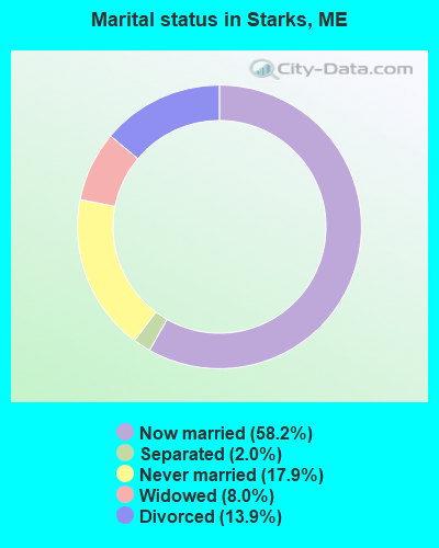
- Never married: 17.9%
- Now married: 58.2%
- Separated: 2.0%
- Widowed: 8.0%
- Divorced: 13.9%
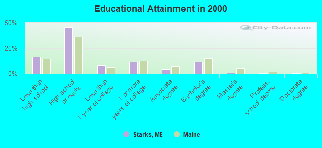
For population 25 years and over in Starks:
- High school or higher: 83.5%
- Bachelor's degree or higher: 13.9%
- Graduate or professional degree: 2.4%
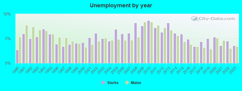
- Unemployed: 7.3%
- Mean travel time to work (commute): 28.4 minutes
| Here: | 9.9 |
| Maine average: | 11.2 |

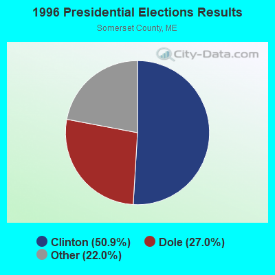
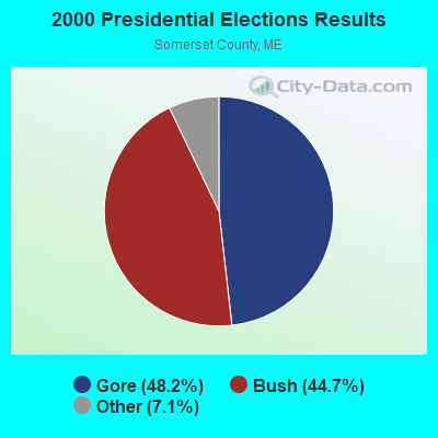
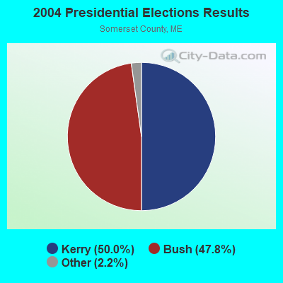
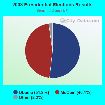
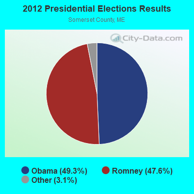
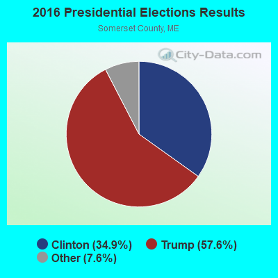
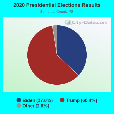
Graphs represent county-level data. Detailed 2008 Election Results
Religion statistics for Starks, ME (based on Somerset County data)
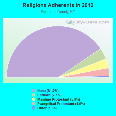
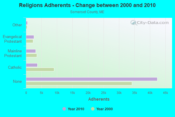
| Religion | Adherents | Congregations |
|---|---|---|
| Catholic | 3,694 | 7 |
| Mainline Protestant | 3,094 | 28 |
| Evangelical Protestant | 2,552 | 32 |
| Other | 501 | 3 |
| None | 42,387 | - |
Food Environment Statistics:
| Somerset County: | 2.52 / 10,000 pop. |
| Maine: | 2.80 / 10,000 pop. |
| Somerset County: | 0.19 / 10,000 pop. |
| State: | 0.14 / 10,000 pop. |
| This county: | 2.71 / 10,000 pop. |
| Maine: | 2.20 / 10,000 pop. |
| Here: | 9.31 / 10,000 pop. |
| Maine: | 5.75 / 10,000 pop. |
| Somerset County: | 8.14 / 10,000 pop. |
| State: | 11.02 / 10,000 pop. |
| Somerset County: | 10.2% |
| Maine: | 8.2% |
| Somerset County: | 31.7% |
| Maine: | 25.0% |
Strongest AM radio stations in Starks:
- WSKW (1160 AM; 10 kW; SKOWHEGAN, ME; Owner: MOUNTAIN WIRELESS, INCORPORATED)
- WTME (780 AM; 10 kW; RUMFORD, ME; Owner: MOUNTAIN VALLEY BROADCASTING, INC.)
- WFAU (1280 AM; 5 kW; GARDINER, ME; Owner: CAPSTAR TX LIMITED PARTNERSHIP)
- WRKO (680 AM; 50 kW; BOSTON, MA; Owner: ENTERCOM BOSTON LICENSE, LLC)
- WZON (620 AM; 5 kW; BANGOR, ME; Owner: THE ZONE CORPORATION)
- WMTW (870 AM; 10 kW; GORHAM, ME; Owner: RADIO PARTNERS OF MAINE, L.P.)
- WTVL (1490 AM; 1 kW; WATERVILLE, ME; Owner: CITADEL BROADCASTING COMPANY)
- WEEI (850 AM; 50 kW; BOSTON, MA; Owner: ENTERCOM BOSTON LICENSE, LLC)
- WBZ (1030 AM; 50 kW; BOSTON, MA; Owner: INFINITY BROADCASTING OPERATIONS, INC.)
- WABI (910 AM; 5 kW; BANGOR, ME; Owner: CLEAR CHANNEL BROADCASTING LICENSES, INC.)
- WCHP (760 AM; 35 kW; CHAMPLAIN, NY; Owner: CHAMPLAIN RADIO, INC.)
- WGAN (560 AM; 5 kW; PORTLAND, ME; Owner: SAGA COMMUNICATIONS OF NEW ENGLAND, LLC)
- WCRN (830 AM; 50 kW; WORCESTER, MA; Owner: CARTER BROADCASTING CORPORATION)
Strongest FM radio stations in Starks:
- WIGY (97.5 FM; MADISON, ME; Owner: CAPSTAR TX LIMITED PARTNERSHIP)
- WHQO (107.9 FM; SKOWHEGAN, ME; Owner: MOUNTAIN WIRELESS, INC.)
- WTOS-FM (105.1 FM; SKOWHEGAN, ME; Owner: CAPSTAR TX LIMITED PARTNERSHIP)
- WLOB-FM (96.3 FM; RUMFORD, ME; Owner: ATLANTIC COAST RADIO, LLC)
- WPKQ (103.7 FM; NORTH CONWAY, NH; Owner: CITADEL BROADCASTING COMPANY)
- WKTJ-FM (99.3 FM; FARMINGTON, ME; Owner: FRANKLIN BROADCASTING CORPORATION)
- WHOM (94.9 FM; MT. WASHINGTON, NH; Owner: CITADEL BROADCASTING COMPANY)
- WTBM (100.7 FM; MEXICO, ME; Owner: MOUNTAIN VALLEY BROADCASTING, INC.)
- WWWA (95.3 FM; WINSLOW, ME; Owner: LIGHT OF LIFE MINISTRIES, INC.)
- WCTB (93.5 FM; FAIRFIELD, ME; Owner: MOUNTAIN WIRELESS, INC.)
- WWBX (97.1 FM; BANGOR, ME; Owner: CLEAR CHANNEL BROADCASTING LICENSES, INC.)
- WQCB (106.5 FM; BREWER, ME; Owner: CUMULUS LICENSING CORP.)
- WEBB (98.5 FM; WATERVILLE, ME; Owner: CITADEL BROADCASTING COMPANY)
- WMME-FM (92.3 FM; AUGUSTA, ME; Owner: CITADEL BROADCASTING COMPANY)
- WMEW (91.3 FM; WATERVILLE, ME; Owner: MAINE PUBLIC BROADCASTING CORPORATION)
TV broadcast stations around Starks:
- W21BI (Channel 21; FARMINGTON, ME; Owner: TRINITY BROADCASTING NETWORK)
- WFYW-LP (Channel 69; FAIRFIELD/WATERVILLE, ME; Owner: THREE ANGELS BROADCASTING NETWORK, INC.)
Starks fatal accident list:
Sep 17, 2013 10:39 AM, Sr-43, Lat: 44.723556, Lon: -69.968486, Vehicles: 2, Persons: 1, Pedestrians: 1, Fatalities: 1
Apr 28, 2006 02:00 PM, Mayhew Road, Lat: 44.754330, Lon: -69.950250, Vehicles: 1, Persons: 1, Fatalities: 1
Jan 22, 2002 11:33 AM, Sr-43, Vehicles: 1, Persons: 3, Fatalities: 2
Nov 10, 1991 07:30 PM, 43, Vehicles: 1, Persons: 1, Fatalities: 1
- National Bridge Inventory (NBI) Statistics
- 5Number of bridges
- 26ft / 7.8mTotal length
- 1,758Total average daily traffic
- 86Total average daily truck traffic
- 2,812Total future (year 2036) average daily traffic
FCC Registered Antenna Towers:
10 (See the full list of FCC Registered Antenna Towers in Starks)FCC Registered Microwave Towers:
1- Starks, 171 Locke Hill Road (Lat: 44.724750 Lon: -69.974667), Type: Ltower, Structure height: 59.7 m, Overall height: 60.7 m, Call Sign: WQXG276,
Assigned Frequencies: 11225.0 MHz, 11225.0 MHz, 11225.0 MHz, 11225.0 MHz, 11225.0 MHz, 11225.0 MHz, 11225.0 MHz, 11225.0 MHz, 11225.0 MHz, Grant Date: 02/24/2016, Expiration Date: 02/24/2026, Cancellation Date: 04/15/2020, Certifier: Jessica B Lyons, Registrant: At&t Services, Inc., 208 S. Akard Street, Room 2100, Dallas, TX 75202, Phone: (855) 699-7073, Email:
FCC Registered Amateur Radio Licenses:
7- Call Sign: KA1WEZ, Licensee ID: L00272497, Grant Date: 07/28/2000, Expiration Date: 07/10/2010, Cancellation Date: 07/11/2012, Registrant: Tobin M Carson, Rr1, Starks, ME 04911
- Call Sign: KB1DBJ, Licensee ID: L01390962, Grant Date: 06/24/2019, Expiration Date: 06/23/2029, Certifier: Cora I Comstock, Registrant: Cora I Comstock, 58 Comstock Farm Rd., Starks, ME 04911
- Call Sign: N1YJS, Grant Date: 01/10/1997, Expiration Date: 01/10/2007, Cancellation Date: 01/13/2009, Registrant: Charles L G Comstock, Box 1160 Rfd 1 Old Gilmore Rd, Starks, ME 04911
- Call Sign: N1ZUC, Licensee ID: L00156032, Grant Date: 10/05/2017, Expiration Date: 11/07/2027, Registrant: Darrell A Dyke, 2470 Industry Rd, Starks, ME 04911
- Call Sign: WA1LJC, Licensee ID: L01225479, Grant Date: 12/09/2016, Expiration Date: 02/25/2027, Certifier: William A Fox, Registrant: William A Fox, 1115 New Sharon Road, Starks, ME 04911
- Call Sign: WA1YJY, Licensee ID: L01230609, Grant Date: 02/14/2017, Expiration Date: 02/25/2027, Registrant: Craig Comstock, 58 Comstock Farm Rd., Starks, ME 04911-4510
- Call Sign: KB1OVX, Licensee ID: L01268020, Grant Date: 04/11/2007, Expiration Date: 04/11/2017, Cancellation Date: 04/12/2019, Certifier: Leland F Dyke, Registrant: Leland F Dyke, Rr 1 Box 1116 Industry Rd, Starks, ME 04911
FAA Registered Aircraft:
1- Aircraft: OSHEA KEVIN C AVID FLYER MK IV (Category: Amphibian, Seats: 2, Weight: Up to 12,499 Pounds), Engine: SUBARU ALL MDLS A/B (400 HP) (Reciprocating)
N-Number: 2264R, N2264R, N-2264R, Serial Number: 1339D, Airworthiness Date: 03/29/1995
Registrant (Individual): Pending Registration, 110 Emery Rd, Starks, ME 04911
Deregistered: Cancel Date: 10/12/2018
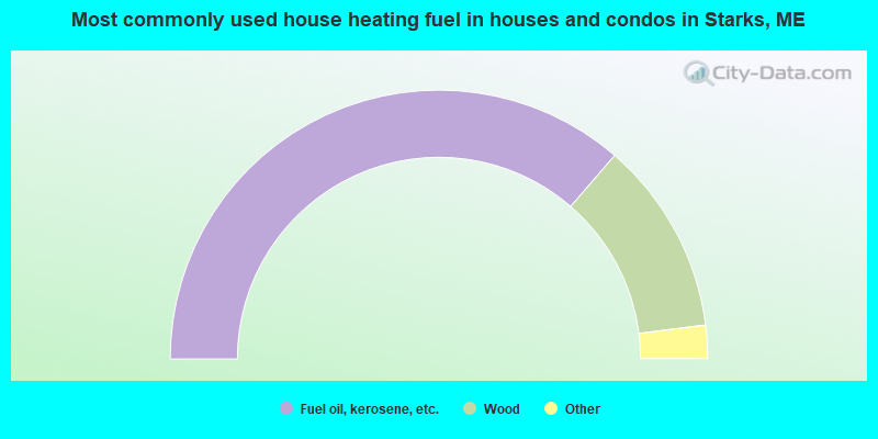
- 72.7%Fuel oil, kerosene, etc.
- 23.3%Wood
- 2.8%Bottled, tank, or LP gas
- 1.1%Coal or coke
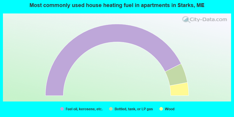
- 85.3%Fuel oil, kerosene, etc.
- 8.8%Bottled, tank, or LP gas
- 5.9%Wood
Starks compared to Maine state average:
- Median house value below state average.
- Unemployed percentage below state average.
- Black race population percentage significantly below state average.
- Hispanic race population percentage significantly below state average.
- Foreign-born population percentage significantly below state average.
- Renting percentage below state average.
- Length of stay since moving in significantly above state average.
- Number of rooms per house significantly below state average.
- House age significantly below state average.
- Number of college students below state average.
- Percentage of population with a bachelor's degree or higher below state average.