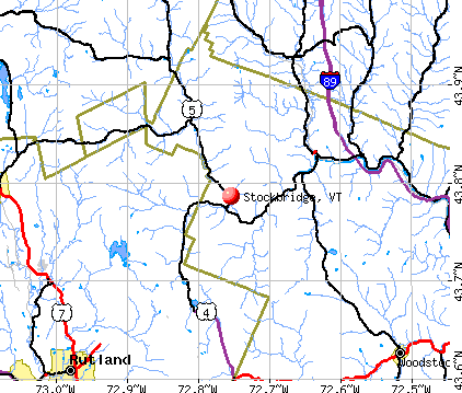
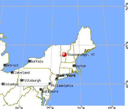
Stockbridge, Vermont
Submit your own pictures of this town and show them to the world
- OSM Map
- General Map
- Google Map
- MSN Map
Population change since 2000: +9.2%
 |
| Males: 369 | |
| Females: 367 |
| Median resident age: | 46.5 years |
| Vermont median age: | 45.8 years |
Zip codes: 05772.
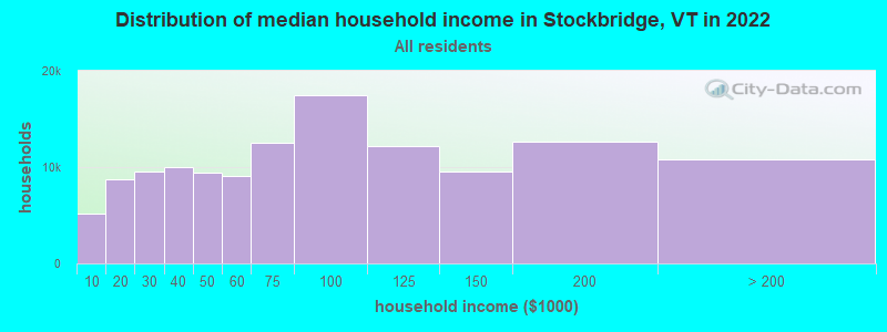
| Stockbridge: | $63,672 |
| VT: | $73,991 |
Estimated per capita income in 2022: $41,834 (it was $21,379 in 2000)
Stockbridge town income, earnings, and wages data
Estimated median house or condo value in 2022: $250,406 (it was $100,500 in 2000)
| Stockbridge: | $250,406 |
| VT: | $304,700 |
Mean prices in 2022: all housing units: $358,264; detached houses: $381,996; townhouses or other attached units: $340,107; in 2-unit structures: $283,645; in 3-to-4-unit structures: $498,076; in 5-or-more-unit structures: $190,965; mobile homes: $75,013
Detailed information about poverty and poor residents in Stockbridge, VT
Compare current foreclosures near Stockbridge, VT:
| Photo | Address | Area | Beds / Baths | Price | Details |
|---|---|---|---|---|---|

|
#1
Doe Hill Way
Woodstock, VT 05091
|
1,264 sq. feet
|
1 baths 1 beds |
$262,900
|
show details |

|
#2
Dartt Hill Rd, # Po122
Bethel, VT 05032
|
- sq. feet
|
- baths - beds |
show details | |

|
#3
Monarch Hill Rd
Tunbridge, VT 05077
|
- sq. feet
|
- baths - beds |
show details | |

|
#4
Dairy Hill Rd
South Royalton, VT 05068
|
- sq. feet
|
- baths - beds |
show details | |

|
#5
Columbian Ave Apt 2
Rutland, VT 05701
|
- sq. feet
|
- baths - beds |
show details | |

|
#6
1/2 State St, # 2
Rutland, VT 05701
|
- sq. feet
|
- baths - beds |
show details | |

|
#7
Pine St # 5
Rutland, VT 05701
|
- sq. feet
|
- baths - beds |
show details | |

|
#8
Regency Mnr Apt 13-4
Rutland, VT 05701
|
- sq. feet
|
- baths - beds |
show details | |

|
#9
Library Ave
Rutland, VT 05701
|
- sq. feet
|
- baths - beds |
show details | |

|
#10
1/2 Kingsley Ave
Rutland, VT 05701
|
- sq. feet
|
- baths - beds |
show details |
| Photo | Address | Area | Beds / Baths | Price | Details |
|---|---|---|---|---|---|

|
#11
Commons St # C
Rutland, VT 05701
|
- sq. feet
|
- baths - beds |
show details | |

|
#12
Davis St
Rutland, VT 05701
|
- sq. feet
|
- baths - beds |
show details | |

|
#13
Bellevue Ave
Rutland, VT 05701
|
- sq. feet
|
- baths - beds |
show details | |

|
#14
Clematis Ave
Rutland, VT 05701
|
- sq. feet
|
- baths - beds |
show details | |

|
#15
Stratton Rd
Rutland, VT 05701
|
- sq. feet
|
- baths - beds |
show details | |

|
#16
Eastview Ct
Rutland, VT 05701
|
- sq. feet
|
- baths - beds |
show details | |

|
#17
Evergreen Ave
Rutland, VT 05701
|
- sq. feet
|
- baths - beds |
show details | |

|
Check over 1 million property listings on Foreclosure.com!
|
browse all offers | |||

- 71597.1%White alone
- 91.2%Two or more races
- 40.5%Asian alone
- 30.4%American Indian alone
- 30.4%Hispanic
- 20.3%Black alone

Races in Stockbridge detailed stats: ancestries, foreign born residents, place of birth
According to our research of Vermont and other state lists, there were 2 registered sex offenders living in Stockbridge, Vermont as of May 23, 2024.
The ratio of all residents to sex offenders in Stockbridge is 368 to 1.
 Recent articles from our blog. Our writers, many of them Ph.D. graduates or candidates, create easy-to-read articles on a wide variety of topics.

 | Snow In Vermont (17 replies) |
| Life in Woodstock (37 replies) |
| Vermont Weather (3779 replies) |
| Need Help Planning A 7 State New England Fall Foliage Tour (39 replies) |
| One Week in New England ( Starting from Vermont) Suggestions? (10 replies) |
| Fall Foliage Drive--2015 (40 replies) |
Latest news from Stockbridge, VT collected exclusively by city-data.com from local newspapers, TV, and radio stations
Ancestries: English (26.6%), Irish (14.8%), German (9.5%), French (9.3%), Italian (7.7%), French Canadian (6.5%).
Current Local Time: EST time zone
Elevation: 857 feet
Land area: 46.1 square miles.
Population density: 16 people per square mile (very low).
12 residents are foreign born
| This town: | 1.8% |
| Vermont: | 3.8% |
| Stockbridge town: | 1.6% ($1,608) |
| Vermont: | 2.0% ($2,196) |
Nearest city with pop. 50,000+: Manchester, NH  (84.0 miles , pop. 107,006).
Nearest city with pop. 200,000+: Boston, MA (129.9 miles , pop. 589,141).
Nearest city with pop. 1,000,000+: Bronx, NY (209.8 miles , pop. 1,332,650).
Nearest cities:
), ), ), ), )Latitude: 43.76 N, Longitude: 72.74 W
Area code commonly used in this area: 802

Single-family new house construction building permits:
- 2022: 5 buildings, average cost: $279,200
- 2021: 5 buildings, average cost: $259,200
- 2020: 5 buildings, average cost: $248,200
- 2019: 1 building, cost: $282,200
- 2018: 2 buildings, average cost: $249,800
- 2016: 2 buildings, average cost: $246,000
- 2015: 1 building, cost: $226,800
- 2014: 2 buildings, average cost: $211,200
- 2013: 2 buildings, average cost: $193,300
- 2012: 2 buildings, average cost: $184,000
- 2011: 4 buildings, average cost: $171,100
- 2010: 1 building, cost: $165,900
- 2009: 1 building, cost: $150,000
- 2008: 1 building, cost: $207,500
- 2007: 3 buildings, average cost: $207,500
- 2006: 10 buildings, average cost: $207,500
- 2005: 11 buildings, average cost: $167,700
- 2004: 5 buildings, average cost: $137,600
- 2003: 7 buildings, average cost: $132,800
- 2002: 4 buildings, average cost: $121,400
- 2001: 4 buildings, average cost: $121,400
- 2000: 3 buildings, average cost: $118,000
- 1999: 5 buildings, average cost: $101,700
- 1998: 8 buildings, average cost: $101,700
- 1997: 2 buildings, average cost: $75,000


| Here: | 1.6% |
| Vermont: | 2.0% |


- Accommodation & food services (12.7%)
- Construction (9.1%)
- Metal & metal products (6.9%)
- Educational services (6.6%)
- Health care (6.1%)
- U. S. Postal service (5.2%)
- Agriculture, forestry, fishing & hunting (5.0%)

- Accommodation & food services (15.7%)
- Construction (13.7%)
- Metal & metal products (9.6%)
- Agriculture, forestry, fishing & hunting (6.6%)
- U. S. Postal service (5.6%)
- Machinery (5.1%)
- Public administration (4.6%)

- Health care (12.0%)
- Educational services (10.8%)
- Accommodation & food services (9.0%)
- Professional, scientific, technical services (5.4%)
- U. S. Postal service (4.8%)
- Building material & garden equipment & supplies dealers (4.8%)
- Public administration (4.8%)

- Other management occupations, except farmers and farm managers (7.7%)
- Building and grounds cleaning and maintenance occupations (5.5%)
- Metal workers and plastic workers (5.2%)
- Information and record clerks, except customer service representatives (4.7%)
- Material recording, scheduling, dispatching, and distributing workers (4.7%)
- Engineers (3.9%)
- Registered nurses (3.9%)

- Other management occupations, except farmers and farm managers (10.2%)
- Metal workers and plastic workers (7.6%)
- Engineers (7.1%)
- Material recording, scheduling, dispatching, and distributing workers (5.6%)
- Laborers and material movers, hand (4.1%)
- Vehicle and mobile equipment mechanics, installers, and repairers (4.1%)
- Building and grounds cleaning and maintenance occupations (3.6%)

- Information and record clerks, except customer service representatives (9.0%)
- Registered nurses (8.4%)
- Building and grounds cleaning and maintenance occupations (7.8%)
- Secretaries and administrative assistants (7.2%)
- Other office and administrative support workers, including supervisors (6.0%)
- Bookkeeping, accounting, and auditing clerks (4.8%)
- Other management occupations, except farmers and farm managers (4.8%)
Average climate in Stockbridge, Vermont
Based on data reported by over 4,000 weather stations


(lower is better)

Air Quality Index (AQI) level in 2022 was 59.9. This is better than average.
| City: | 59.9 |
| U.S.: | 72.6 |

Carbon Monoxide (CO) [ppm] level in 2022 was 0.251. This is about average. Closest monitor was 16.3 miles away from the city center.
| City: | 0.251 |
| U.S.: | 0.251 |

Nitrogen Dioxide (NO2) [ppb] level in 2022 was 6.51. This is worse than average. Closest monitor was 16.3 miles away from the city center.
| City: | 6.51 |
| U.S.: | 5.11 |

Sulfur Dioxide (SO2) [ppb] level in 2022 was 0.299. This is significantly better than average. Closest monitor was 16.3 miles away from the city center.
| City: | 0.299 |
| U.S.: | 1.515 |

Ozone [ppb] level in 2022 was 24.1. This is better than average. Closest monitor was 16.3 miles away from the city center.
| City: | 24.1 |
| U.S.: | 33.3 |

Particulate Matter (PM2.5) [µg/m3] level in 2022 was 6.68. This is better than average. Closest monitor was 16.3 miles away from the city center.
| City: | 6.68 |
| U.S.: | 8.11 |
Tornado activity:
Stockbridge-area historical tornado activity is near Vermont state average. It is 74% smaller than the overall U.S. average.
On 8/20/1968, a category F3 (max. wind speeds 158-206 mph) tornado 45.9 miles away from the Stockbridge town center injured one person and caused between $5000 and $50,000 in damages.
On 10/24/1955, a category F2 (max. wind speeds 113-157 mph) tornado 29.6 miles away from the town center caused between $5000 and $50,000 in damages.
Earthquake activity:
Stockbridge-area historical earthquake activity is significantly above Vermont state average. It is 70% smaller than the overall U.S. average.On 4/20/2002 at 10:50:47, a magnitude 5.3 (5.3 ML, Depth: 3.0 mi, Class: Moderate, Intensity: VI - VII) earthquake occurred 70.5 miles away from the city center
On 10/7/1983 at 10:18:46, a magnitude 5.3 (5.1 MB, 5.3 LG, 5.1 ML) earthquake occurred 81.1 miles away from Stockbridge center
On 4/20/2002 at 10:50:47, a magnitude 5.2 (5.2 MB, 4.2 MS, 5.2 MW, 5.0 MW) earthquake occurred 69.9 miles away from Stockbridge center
On 1/19/1982 at 00:14:42, a magnitude 4.7 (4.5 MB, 4.7 MD, 4.5 LG, Class: Light, Intensity: IV - V) earthquake occurred 59.7 miles away from the city center
On 10/16/2012 at 23:12:25, a magnitude 4.7 (4.7 ML, Depth: 10.0 mi) earthquake occurred 104.7 miles away from Stockbridge center
On 6/16/1995 at 12:13:11, a magnitude 3.8 (3.8 LG, Depth: 3.1 mi, Class: Light, Intensity: II - III) earthquake occurred 54.6 miles away from Stockbridge center
Magnitude types: regional Lg-wave magnitude (LG), body-wave magnitude (MB), duration magnitude (MD), local magnitude (ML), surface-wave magnitude (MS), moment magnitude (MW)
Natural disasters:
The number of natural disasters in Windsor County (20) is greater than the US average (15).Major Disasters (Presidential) Declared: 16
Emergencies Declared: 2
Causes of natural disasters: Floods: 14, Storms: 13, Tropical Storms: 2, Heavy Rain: 1, Hurricane: 1, Ice Storm: 1, Landslide: 1, Snowstorm: 1, Wind: 1, Winter Storm: 1 (Note: some incidents may be assigned to more than one category).
Hospitals and medical centers near Stockbridge:
- GIFFORD MEDICAL CENTER Critical Access Hospitals (about 12 miles away; RANDOLPH, VT)
- MENIG EXTENDED CARE (Nursing Home, about 12 miles away; RANDOLPH, VT)
- GIFFORD ELDERLY CARE INC (Nursing Home, about 12 miles away; RANDOLPH, VT)
- WESTVIEW COURT (Hospital, about 16 miles away; RUTLAND, VT)
- RUTLAND AREA VNA (Home Health Center, about 16 miles away; RUTLAND, VT)
- RUTLAND HEALTHCARE AND REHABILITATION CENTER (Nursing Home, about 16 miles away; RUTLAND, VT)
Amtrak stations near Stockbridge:
- 8 miles: KILLINGTON (RTE 4) - Seasonal Bus Station . Services: fully wheelchair accessible, enclosed waiting area, public payphones, snack bar, free short-term parking, call for car rental service, call for taxi service, public transit connection.
- 12 miles: RANDOLPH (DEPOT SQ.) . Services: enclosed waiting area, public restrooms, public payphones, snack bar, ATM, free short-term parking, free long-term parking, public transit connection.
- 17 miles: RUTLAND (MERCHANTS ROW) . Services: ticket office, fully wheelchair accessible, enclosed waiting area, public restrooms, public payphones, vending machines, free short-term parking, free long-term parking, call for car rental service, call for taxi service, intercity bus service, public transit connection.
Colleges/universities with over 2000 students nearest to Stockbridge:
- Dartmouth College (about 23 miles; Hanover, NH; Full-time enrollment: 6,030)
- Castleton State College (about 25 miles; Castleton, VT; FT enrollment: 2,079)
- Norwich University (about 27 miles; Northfield, VT; FT enrollment: 4,221)
- Middlebury College (about 28 miles; Middlebury, VT; FT enrollment: 3,077)
- Plymouth State University (about 53 miles; Plymouth, NH; FT enrollment: 4,838)
- Adirondack Community College (about 54 miles; Queensbury, NY; FT enrollment: 2,826)
- Champlain College (about 55 miles; Burlington, VT; FT enrollment: 2,623)
Public elementary/middle school in Stockbridge:
- STOCKBRIDGE CENTRAL SCHOOL (Students: 72, Location: 2933 VT ROUTE 107, Grades: PK-6)
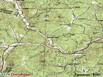
Points of interest:
Notable locations in Stockbridge: White River Valley Camping Area (A), Trail Head Ski Touring Center (B), Trail Head Winter Sports Area (C), Stockbridge Volunteer Fire Department (D). Display/hide their locations on the map
Cemeteries: Maplewood Cemetery (1), South Hill Cemetery (2), Sylvester Plot Cemetery (3), Mount Pleasant Cemetery (4), Betsy Bartlett Grave (5), Abbott Cemetery (6). Display/hide their locations on the map
Streams, rivers, and creeks: Stony Brook (A), Tweed River (B), Taggart Brook (C), Perkins Brook (D), Mink Brook (E), Brown Brook (F), Lilliesville Brook (G), Johnson Brook (H), Boutwell Brook (I). Display/hide their locations on the map
Park in Stockbridge: Stockbridge Common Historic District (1). Display/hide its location on the map
Birthplace of: George Crockett Strong - Union Army generals.
Drinking water stations with addresses in Stockbridge and their reported violations in the past:
STOCKBRIDGE CENTRAL SCHOOL (Address: 2933 VT RTE 107 , Population served: 100, Groundwater):Past health violations:Past monitoring violations:
- MCL, Monthly (TCR) - In JAN-2009, Contaminant: Coliform. Follow-up actions: St Boil Water Order (JAN-09-2009), St Formal NOV issued (JAN-09-2009), St Tech Assistance Visit (JAN-09-2009), St Public Notif requested (JAN-09-2009), St Compliance achieved (AUG-09-2010)
- Follow-up Or Routine LCR Tap M/R - In JAN-01-1997, Contaminant: Lead and Copper Rule. Follow-up actions: St Violation/Reminder Notice (JUL-01-1997), St Compliance achieved (FEB-10-2010)
| This town: | 2.2 people |
| Vermont: | 2.3 people |
| This town: | 61.4% |
| Whole state: | 62.5% |
| This town: | 8.8% |
| Whole state: | 9.2% |
Likely homosexual households (counted as self-reported same-sex unmarried-partner households)
- Lesbian couples: 0.6% of all households
- Gay men: 0.3% of all households
| This town: | 5.3% |
| Whole state: | 9.4% |
| This town: | 2.4% |
| Whole state: | 3.6% |
For population 15 years and over in Stockbridge:

- Never married: 20.0%
- Now married: 60.6%
- Separated: 2.2%
- Widowed: 10.3%
- Divorced: 7.0%
For population 25 years and over in Stockbridge:
- High school or higher: 88.4%
- Bachelor's degree or higher: 24.6%
- Graduate or professional degree: 6.3%
- Mean travel time to work (commute): 28.7 minutes


| Here: | 9.7 |
| Vermont average: | 11.7 |
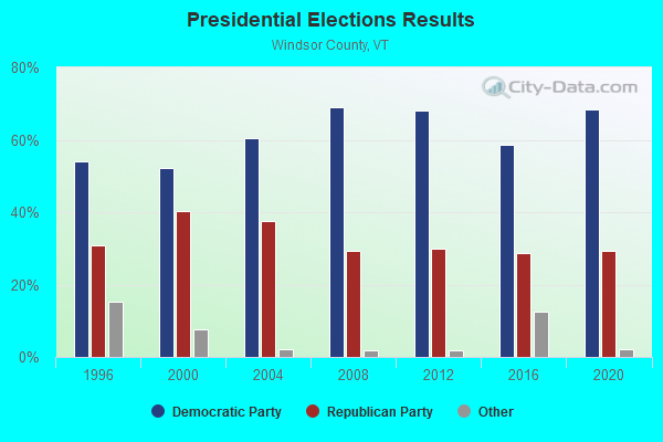
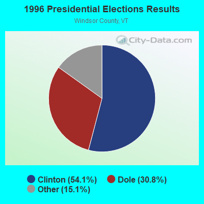
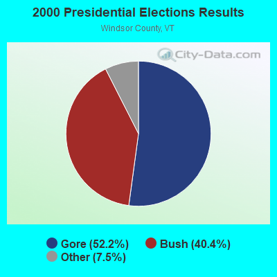
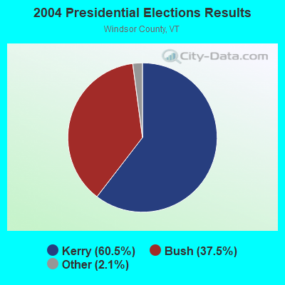
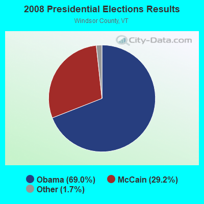
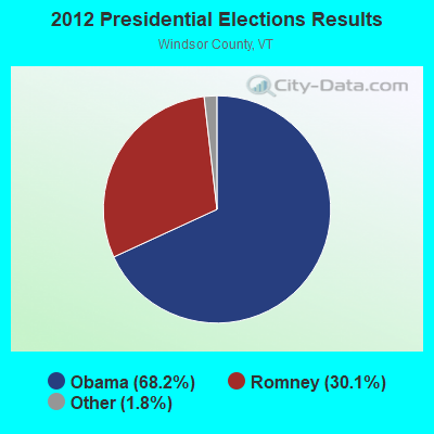
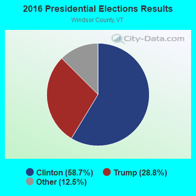
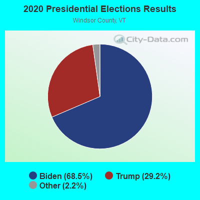
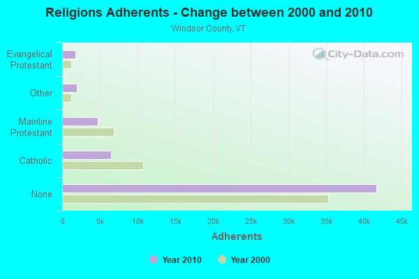
Graphs represent county-level data. Detailed 2008 Election Results
Religion statistics for Stockbridge, VT (based on Windsor County data)
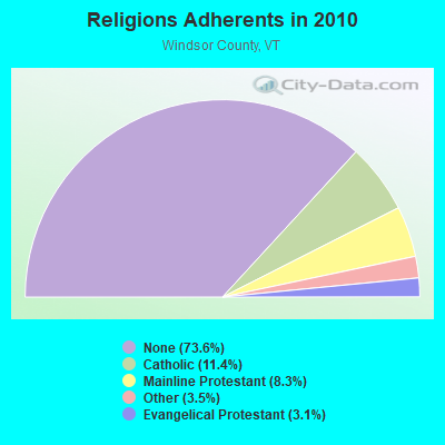
| Religion | Adherents | Congregations |
|---|---|---|
| Catholic | 6,485 | 10 |
| Mainline Protestant | 4,700 | 45 |
| Other | 1,964 | 17 |
| Evangelical Protestant | 1,750 | 21 |
| Orthodox | 55 | 1 |
| None | 41,716 | - |
Food Environment Statistics:
| Here: | 4.93 / 10,000 pop. |
| Vermont: | 3.84 / 10,000 pop. |
| Windsor County: | 1.23 / 10,000 pop. |
| Vermont: | 1.95 / 10,000 pop. |
| Windsor County: | 7.93 / 10,000 pop. |
| Vermont: | 6.40 / 10,000 pop. |
| Windsor County: | 14.97 / 10,000 pop. |
| Vermont: | 11.52 / 10,000 pop. |
| Windsor County: | 7.1% |
| Vermont: | 6.8% |
| This county: | 22.8% |
| State: | 22.3% |
| This county: | 9.7% |
| Vermont: | 13.3% |
Businesses in Stockbridge, VT
- Ford: 1
Strongest AM radio stations in Stockbridge:
- WSYB (1380 AM; 5 kW; RUTLAND, VT; Owner: CAPSTAR TX LIMITED PARTNERSHIP)
- WGY (810 AM; 50 kW; SCHENECTADY, NY; Owner: CLEAR CHANNEL BROADCASTING LICENSES, INC.)
- WNTK (1020 AM; 10 kW; NEWPORT, NH; Owner: KOOR COMMUNICATIONS, INC.)
- WNNZ (640 AM; 50 kW; WESTFIELD, MA; Owner: CLEAR CHANNEL BROADCASTING LICENSES, INC.)
- WCHP (760 AM; 35 kW; CHAMPLAIN, NY; Owner: CHAMPLAIN RADIO, INC.)
- WRKO (680 AM; 50 kW; BOSTON, MA; Owner: ENTERCOM BOSTON LICENSE, LLC)
- WDEV (550 AM; 5 kW; WATERBURY, VT; Owner: RADIO VERMONT, INC.)
- WCRN (830 AM; 50 kW; WORCESTER, MA; Owner: CARTER BROADCASTING CORPORATION)
- WWWT (1320 AM; 1 kW; RANDOLPH, VT; Owner: CAPSTAR TX LIMITED PARTNERSHIP)
- WPTR (1540 AM; 50 kW; ALBANY, NY; Owner: KIMTRON, INC.)
- WEEI (850 AM; 50 kW; BOSTON, MA; Owner: ENTERCOM BOSTON LICENSE, LLC)
- WICY (1490 AM; 50 kW; MALONE, NY; Owner: CARTIER COMMUNICATIONS INC.)
- WKOX (1200 AM; 50 kW; FRAMINGHAM, MA; Owner: CAPSTAR TX LIMITED PARTNERSHIP)
Strongest FM radio stations in Stockbridge:
- WEBK (105.3 FM; KILLINGTON, VT; Owner: 6 JOHNSON ROAD LICENSES, INC.)
- WGLV (91.7 FM; WOODSTOCK, VT; Owner: CHRISTIAN MINISTRIES INC)
- WHDQ-FM1 (106.1 FM; RUTLAND, VT; Owner: GREAT NORTHERN RADIO, L.L.C.)
- WJJR (98.1 FM; RUTLAND, VT; Owner: 6 JOHNSON ROAD LICENSES, INC.)
- WZRT (97.1 FM; RUTLAND, VT; Owner: CAPSTAR TX LIMITED PARTNERSHIP)
- WJEN (94.5 FM; RUTLAND, VT; Owner: 6 JOHNSON ROAD LICENSES, INC.)
- WDEV-FM (96.1 FM; WARREN, VT; Owner: RADIO VERMONT, INC.)
- WVPR (89.5 FM; WINDSOR, VT; Owner: VERMONT PUBLIC RADIO)
- WEXP (101.5 FM; BRANDON, VT; Owner: VOX VERMONT, L.L.C.)
- WHDQ (106.1 FM; CLAREMONT, NH; Owner: GREAT NORTHERN RADIO, L.L.C.)
- WMXR (93.9 FM; WOODSTOCK, VT; Owner: CLEAR CHANNEL BROADCASTING LICENSES, INC.)
- WCVT (101.7 FM; STOWE, VT; Owner: RADIO VERMONT CLASSICS, L.L.C.)
- WRJT (103.1 FM; ROYALTON, VT; Owner: LISBON COMMUNICATIONS, INC.)
- WEQX (102.7 FM; MANCHESTER, VT; Owner: NORTHSHIRE COMMUNICATIONS, INC.)
- WJAN (95.1 FM; SUNDERLAND, VT; Owner: 6 JOHNSON ROAD LICENSES, INC.)
- WEVH (91.3 FM; HANOVER, NH; Owner: NEW HAMPSHIRE PUBLIC RADIO INC)
- WVPS (107.9 FM; BURLINGTON, VT; Owner: VERMONT PUBLIC RADIO)
- WEZF (92.9 FM; BURLINGTON, VT; Owner: CAPSTAR TX LIMITED PARTNERSHIP)
- WLKC (103.3 FM; WATERBURY, VT; Owner: RADIO BROADCASTING SERVICES, INC.)
- WNCS (104.7 FM; MONTPELIER, VT; Owner: MONTPELIER BROADCASTING, INC.)
TV broadcast stations around Stockbridge:
- WVER (Channel 28; RUTLAND, VT; Owner: VERMONT ETV, INC.)
- WVTA (Channel 41; WINDSOR, VT; Owner: VERMONT ETV, INC.)
- W61CE (Channel 61; RUTLAND, VT; Owner: MARGARET SANGUINETTI (ADMINISTRATRIX OF THE ESTATE))
- W07AG (Channel 7; RUTLAND, VT; Owner: WNYT INC.)
- W69AR (Channel 69; RUTLAND, VT; Owner: MT. MANSFIELD TELEVISION, INC.)
- Stockbridge, Vermont
- Fatal accident count14
- Vehicles involved in fatal accidents22
- Fatal accidents involving drunk persons:6
- Fatalities15
- Persons involved in fatal accidents33
- Pedestrians involved in fatal accidents0
- Vermont average
- Fatal accident count997
- Vehicles involved in fatal accidents1436
- Fatal accidents involving drunk persons390
- Fatalities1117
- Persons involved in fatal accidents2398
- Pedestrians involved in fatal accidents52
- National Bridge Inventory (NBI) Statistics
- 14Number of bridges
- 115ft / 35.4mTotal length
- $4,229,000Total costs
- 10,560Total average daily traffic
- 852Total average daily truck traffic
- 11,092Total future (year 2026) average daily traffic

- New bridges - historical statistics
- 21920-1929
- 11930-1939
- 41970-1979
- 21990-1999
- 22000-2009
- 32010-2019
FCC Registered Antenna Towers:
7- Delilah Leggett, 1475 Vt Route 100 (Lat: 43.780611 Lon: -72.764611), Type: 54.9, Structure height: 50027 m, Overall height: 54.9 m, Registrant: Gmr Holdings Of Nh, LLC, Delilah@greenmtncomm.Com, , Pembr-oke, Phone: (603) 717-7117
- Delilah Leggett, 1475 Vt Route 100 (Lat: 43.780611 Lon: -72.764611), Type: 54.9, Structure height: 50027 m, Overall height: 54.9 m, Registrant: Gmr Holdings Of Nh, LLC, Delilah@greenmtncomm.Com, , Pembr-oke, Phone: (603) 717-7117
- Delilah Leggett, 1475 Vt Route 100 (Lat: 43.780611 Lon: -72.764611), Type: 54.9, Structure height: 50027 m, Overall height: 54.9 m, Registrant: Gmr Holdings Of Nh, LLC, Delilah@greenmtncomm.Com, , Pembr-oke, Phone: (603) 717-7117
- Delilah Leggett, 1475 Vt Route 100 (Lat: 43.780611 Lon: -72.764611), Type: 54.9, Structure height: 50027 m, Overall height: 54.9 m, Registrant: Gmr Holdings Of Nh, LLC, Delilah@greenmtncomm.Com, , Pembr-oke, Phone: (603) 717-7117
- Delilah Leggett, 1475 Vt Route 100 (Lat: 43.780611 Lon: -72.764611), Type: 54.9, Structure height: 50027 m, Overall height: 54.9 m, Registrant: Gmr Holdings Of Nh, LLC, Delilah@greenmtncomm.Com, , Pembr-oke, Phone: (603) 717-7117
- Delilah Leggett, 1475 Vt Route 100 (Lat: 43.780611 Lon: -72.764611), Type: 54.9, Structure height: 50027 m, Overall height: 54.9 m, Licensee ID: L, Registrant: Gmr Holdings Of Nh, LLC, Delilah@greenmtncomm.Com, , 702 RIVERWOOD DRIVE Pembr-oke, Phone: (603) 717-7117
- Delilah Leggett, 1475 Vt Route 100 (Lat: 43.780611 Lon: -72.764611), Type: 54.9, Structure height: 50027 m, Overall height: 54.9 m, Registrant: Gmr Holdings Of Nh, LLC, Delilah@greenmtncomm.Com, , Pembr-oke, Phone: (603) 717-7117
FCC Registered Broadcast Land Mobile Towers:
1- Lat: 43.775333 Lon: -72.765861, Call Sign: WRCY517,
Assigned Frequencies: 173.337 MHz, 173.337 MHz, Grant Date: 02/26/2019, Expiration Date: 02/26/2029, Certifier: Gordon Lunna, Registrant: Cara Enterprises, Inc, Las Vegas, NV 89140-0124, Phone: (702) 838-9728, Fax: (702) 363-4607, Email:
FCC Registered Amateur Radio Licenses:
1- Call Sign: KC1TQA, Licensee ID: L02716564, Grant Date: 10/28/2023, Expiration Date: 10/28/2033, Certifier: Lucas M Gibson, Registrant: Lucas M Gibson, Stockbridge, VT 05772

- 41.2%Fuel oil, kerosene, etc.
- 28.5%Bottled, tank, or LP gas
- 21.9%Wood
- 5.4%Electricity
- 1.5%Utility gas
- 1.5%Other fuel

- 44.0%Fuel oil, kerosene, etc.
- 28.0%Wood
- 20.0%Bottled, tank, or LP gas
- 8.0%Electricity
Stockbridge compared to Vermont state average:
- Unemployed percentage significantly below state average.
- Black race population percentage significantly below state average.
- Hispanic race population percentage significantly below state average.
- Foreign-born population percentage significantly below state average.
- Renting percentage below state average.
- Length of stay since moving in significantly above state average.
- Number of rooms per house significantly below state average.
- House age significantly below state average.