Stratton, Ohio
Submit your own pictures of this village and show them to the world
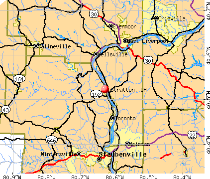
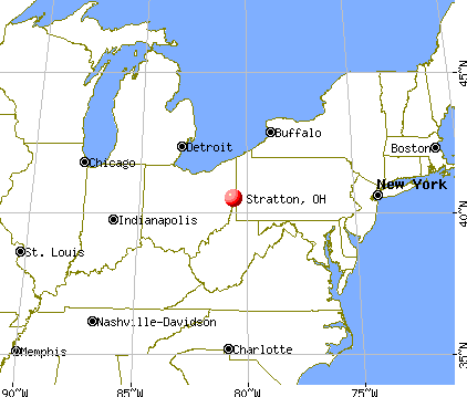
- OSM Map
- General Map
- Google Map
- MSN Map
Population change since 2000: -5.8%
 |
| Males: 134 | |
| Females: 127 |
| Median resident age: | 42.1 years |
| Ohio median age: | 39.9 years |
Zip codes: 43961.
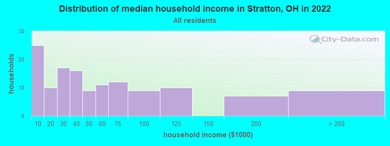
| Stratton: | $39,855 |
| OH: | $65,720 |
Estimated per capita income in 2022: $32,870 (it was $16,967 in 2000)
Stratton village income, earnings, and wages data
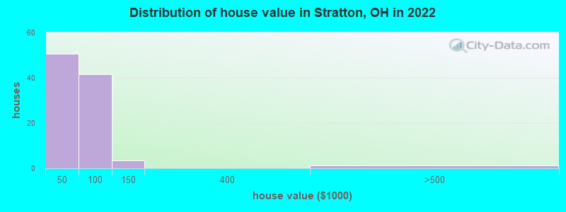
Estimated median house or condo value in 2022: $55,674 (it was $25,000 in 2000)
| Stratton: | $55,674 |
| OH: | $204,100 |
Mean prices in 2022: all housing units: $53,607; detached houses: $78,358; mobile homes: $11,807
Median gross rent in 2022: $679.
Detailed information about poverty and poor residents in Stratton, OH
Compare current foreclosures near Stratton, OH:
| Photo | Address | Area | Beds / Baths | Price | Details |
|---|---|---|---|---|---|

|
#1
Saint Clair Ave
Mingo Junction, OH 43938
|
1,320 sq. feet
|
1 baths 3 beds |
$19,900
|
show details |

|
#2
N 3rd St
Toronto, OH 43964
|
1,406 sq. feet
|
1 baths 3 beds |
$142,000
|
show details |

|
#3
Madison Ave
Toronto, OH 43964
|
1,024 sq. feet
|
1 baths 3 beds |
$104,900
|
show details |

|
#4
State Route 151
Mingo Junction, OH 43938
|
1,477 sq. feet
|
1 baths 3 beds |
show details | |

|
#5
Violet Dr
New Cumberland, WV 26047
|
1,368 sq. feet
|
2 baths 3 beds |
show details | |

|
#6
Garfield Way
Follansbee, WV 26037
|
2,328 sq. feet
|
2 baths 3 beds |
show details | |

|
#7
Highland St
Follansbee, WV 26037
|
1,450 sq. feet
|
1 baths 3 beds |
show details | |

|
#8
Troy Dr
Steubenville, OH 43953
|
1,120 sq. feet
|
1 baths 3 beds |
show details | |

|
#9
Hollywood Blvd
Steubenville, OH 43952
|
1,065 sq. feet
|
1 baths 2 beds |
show details | |

|
#10
Cleveland Ave
Steubenville, OH 43952
|
1,128 sq. feet
|
1 baths 3 beds |
show details |
| Photo | Address | Area | Beds / Baths | Price | Details |
|---|---|---|---|---|---|

|
#11
Midland Beaver Rd
Industry, PA 15052
|
- sq. feet
|
1 baths 2 beds |
show details | |

|
#12
W Cir Dr
Weirton, WV 26062
|
1,804 sq. feet
|
4 baths 3 beds |
show details | |

|
#13
Christy Dr
Aliquippa, PA 15001
|
7,524 sq. feet
|
3 baths 7 beds |
show details | |

|
#14
Horse Shoe Driv
Clinton, PA 15026
|
- sq. feet
|
2 baths 4 beds |
show details | |

|
#15
Woodland Ave
Steubenville, OH 43952
|
960 sq. feet
|
1 baths 3 beds |
show details | |

|
#16
Floyd St
Steubenville, OH 43953
|
1,020 sq. feet
|
1 baths 3 beds |
show details | |

|
#17
Beechwood Blvd
Steubenville, OH 43953
|
900 sq. feet
|
1 baths 3 beds |
show details | |

|
#18
Douglas Ave
Steubenville, OH 43953
|
1,161 sq. feet
|
1 baths 3 beds |
show details | |

|
#19
Bantam Ridge Rd
Steubenville, OH 43953
|
950 sq. feet
|
1 baths 3 beds |
show details | |

|
#20
Eisenhower Rd
Steubenville, OH 43953
|
1,784 sq. feet
|
2 baths 3 beds |
show details |
| Photo | Address | Area | Beds / Baths | Price | Details |
|---|---|---|---|---|---|

|
#21
Terrace Dr
Steubenville, OH 43953
|
1,426 sq. feet
|
1 baths 3 beds |
show details | |

|
#22
Calcutta Smithferry Rd
East Liverpool, OH 43920
|
1,176 sq. feet
|
1 baths 3 beds |
show details | |

|
#23
Stardust Dr
Steubenville, OH 43953
|
1,392 sq. feet
|
1 baths 3 beds |
show details | |

|
#24
Beaver Ave
Midland, PA 15059
|
1 sq. feet
|
2 baths 2 beds |
show details | |

|
#25
1st Ave
Midland, PA 15059
|
1,131 sq. feet
|
1 baths 3 beds |
show details | |

|
#26
Parkway Estates Dr
New Cumberland, WV 26047
|
960 sq. feet
|
1 baths 2 beds |
show details | |

|
#27
Chestnut St
Steubenville, OH 43952
|
2,100 sq. feet
|
1 baths 2 beds |
show details | |

|
#28
Ridge Ave
Steubenville, OH 43952
|
952 sq. feet
|
2 baths 4 beds |
show details | |

|
#29
E Liverpool Rd
East Liverpool, OH 43920
|
924 sq. feet
|
1 baths 3 beds |
show details | |

|
#30
Whitehaven Blvd
Steubenville, OH 43952
|
1,064 sq. feet
|
1 baths 3 beds |
show details |
| Photo | Address | Area | Beds / Baths | Price | Details |
|---|---|---|---|---|---|

|
#31
Ohio Ave
Midland, PA 15059
|
1,728 sq. feet
|
1 baths 3 beds |
show details | |

|
#32
Fisher Rd
East Liverpool, OH 43920
|
1,008 sq. feet
|
1 baths 3 beds |
show details | |

|
#33
Opal Blvd
Steubenville, OH 43952
|
1,034 sq. feet
|
1 baths 2 beds |
show details | |

|
#34
Hollywood Blvd
Steubenville, OH 43952
|
1,442 sq. feet
|
1 baths 3 beds |
show details | |

|
#35
Glasgow Rd
Wellsville, OH 43968
|
1,050 sq. feet
|
1 baths 2 beds |
show details | |

|
#36
Broadway Blvd
Steubenville, OH 43952
|
1,284 sq. feet
|
1 baths 3 beds |
show details | |

|
#37
E Liverpool Rd
East Liverpool, OH 43920
|
1,144 sq. feet
|
1 baths 3 beds |
show details | |

|
#38
Martha St
East Liverpool, OH 43920
|
912 sq. feet
|
1 baths 2 beds |
show details | |

|
#39
State Route 39
Wellsville, OH 43968
|
1,144 sq. feet
|
1 baths 2 beds |
show details | |

|
#40
Sewickley Ave
Steubenville, OH 43952
|
967 sq. feet
|
1 baths 3 beds |
show details |
| Photo | Address | Area | Beds / Baths | Price | Details |
|---|---|---|---|---|---|

|
#41
Penn Ave
Midland, PA 15059
|
1,400 sq. feet
|
1 baths 2 beds |
show details | |

|
#42
Blueberry Dr
Aliquippa, PA 15001
|
1,891 sq. feet
|
2 baths 3 beds |
show details | |

|
#43
Ohio Ave
Midland, PA 15059
|
1,182 sq. feet
|
1 baths 3 beds |
show details | |

|
#44
Ridgemont Dr
Midland, PA 15059
|
880 sq. feet
|
1 baths 2 beds |
show details | |

|
#45
County Road 19
Mingo Junction, OH 43938
|
816 sq. feet
|
1 baths 2 beds |
show details | |

|
#46
County Road 19
Mingo Junction, OH 43938
|
690 sq. feet
|
1 baths 2 beds |
show details | |

|
#47
Stella St
Burgettstown, PA 15021
|
1,326 sq. feet
|
1 baths 3 beds |
show details | |

|
#48
Patterson Dr
Industry, PA 15052
|
960 sq. feet
|
1 baths 3 beds |
show details | |

|
#49
Mowry Rd
Monaca, PA 15061
|
960 sq. feet
|
1 baths 3 beds |
show details | |

|
Check over 1 million property listings on Foreclosure.com!
|
browse all offers | |||


- 24093.8%White alone
- 62.3%Hispanic
- 52.0%Black alone
- 10.4%Two or more races

Races in Stratton detailed stats: ancestries, foreign born residents, place of birth
 Recent articles from our blog. Our writers, many of them Ph.D. graduates or candidates, create easy-to-read articles on a wide variety of topics.

 | Does anyone else agree the Cincinnati Metro Area is lousy for dating? (47 replies) |
| Want to Know More About Cincinnati! (25 replies) |
| Oakley's History (35 replies) |
| Is It Wise To Move Back To Steubenville Area???????????? (110 replies) |
| Moving To Stratton (2 replies) |
| Great Green Houses in Northwest Ohio/Toledo (7 replies) |
Latest news from Stratton, OH collected exclusively by city-data.com from local newspapers, TV, and radio stations
Ancestries: English (23.3%), Scottish (17.4%), German (9.3%), Irish (9.3%), Polish (9.3%), Eastern European (4.7%).
Current Local Time: EST time zone
Elevation: 676 feet
Land area: 0.53 square miles.
Population density: 491 people per square mile (low).
| Stratton village: | 1.1% ($277) |
| Ohio: | 1.3% ($1,271) |
Nearest city with pop. 50,000+: Pittsburgh, PA  (34.8 miles , pop. 334,563).
Nearest city with pop. 1,000,000+: Philadelphia, PA (291.7 miles , pop. 1,517,550).
Nearest cities:
), ), ), ), Latitude: 40.52 N, Longitude: 80.63 W
| Here: | 4.7% |
| Ohio: | 3.1% |

- Health care (13.5%)
- Public administration (11.7%)
- Metal & metal products (7.2%)
- Accommodation & food services (7.2%)
- Department & other general merchandise stores (6.3%)
- Truck transportation (5.4%)
- Nonmetallic mineral products (4.5%)

- Public administration (18.5%)
- Metal & metal products (14.8%)
- Truck transportation (7.4%)
- Utilities (7.4%)
- Health care (7.4%)
- Electrical & electronic goods merchant wholesalers (5.6%)
- Food & beverage stores (5.6%)

- Health care (19.3%)
- Department & other general merchandise stores (12.3%)
- Accommodation & food services (10.5%)
- Used merchandise, gift, novelty, souvenir, other miscellaneous stores (8.8%)
- Finance & insurance (7.0%)
- Building material & garden equipment & supplies dealers (5.3%)
- Data processing, libraries, other information services (5.3%)

- Cashiers (9.9%)
- Law enforcement workers, including supervisors (6.3%)
- Laborers and material movers, hand (6.3%)
- Other office and administrative support workers, including supervisors (5.4%)
- Electrical equipment mechanics and other installation, maintenance, and repair workers, including supervisors (5.4%)
- Health technologists and technicians (4.5%)
- Art and design workers (4.5%)

- Law enforcement workers, including supervisors (13.0%)
- Laborers and material movers, hand (13.0%)
- Electrical equipment mechanics and other installation, maintenance, and repair workers, including supervisors (11.1%)
- Material recording, scheduling, dispatching, and distributing workers (9.3%)
- Other management occupations, except farmers and farm managers (7.4%)
- Metal workers and plastic workers (7.4%)
- Driver/sales workers and truck drivers (7.4%)

- Cashiers (14.0%)
- Other office and administrative support workers, including supervisors (10.5%)
- Waiters and waitresses (8.8%)
- Art and design workers (8.8%)
- Retail sales workers, except cashiers (8.8%)
- Building and grounds cleaning and maintenance occupations (7.0%)
- Health technologists and technicians (7.0%)
Average climate in Stratton, Ohio
Based on data reported by over 4,000 weather stations


(lower is better)

Air Quality Index (AQI) level in 2023 was 98.4. This is worse than average.
| City: | 98.4 |
| U.S.: | 72.6 |

Carbon Monoxide (CO) [ppm] level in 2016 was 0.282. This is about average. Closest monitor was 6.9 miles away from the city center.
| City: | 0.282 |
| U.S.: | 0.251 |

Nitrogen Dioxide (NO2) [ppb] level in 2023 was 7.85. This is significantly worse than average. Closest monitor was 4.6 miles away from the city center.
| City: | 7.85 |
| U.S.: | 5.11 |

Sulfur Dioxide (SO2) [ppb] level in 2023 was 1.12. This is better than average. Closest monitor was 1.9 miles away from the city center.
| City: | 1.12 |
| U.S.: | 1.51 |

Ozone [ppb] level in 2022 was 31.0. This is about average. Closest monitor was 5.2 miles away from the city center.
| City: | 31.0 |
| U.S.: | 33.3 |

Particulate Matter (PM10) [µg/m3] level in 2023 was 21.3. This is about average. Closest monitor was 0.1 miles away from the city center.
| City: | 21.3 |
| U.S.: | 19.2 |

Particulate Matter (PM2.5) [µg/m3] level in 2023 was 12.2. This is significantly worse than average. Closest monitor was 6.9 miles away from the city center.
| City: | 12.2 |
| U.S.: | 8.1 |

Lead (Pb) [µg/m3] level in 2020 was 0.00256. This is significantly better than average. Closest monitor was 5.2 miles away from the city center.
| City: | 0.00256 |
| U.S.: | 0.00931 |
Tornado activity:
Stratton-area historical tornado activity is slightly below Ohio state average. It is 11% smaller than the overall U.S. average.
On 5/31/1985, a category F5 (max. wind speeds 261-318 mph) tornado 51.7 miles away from the Stratton village center killed 18 people and injured 310 people and caused between $50,000,000 and $500,000,000 in damages.
On 5/31/1985, a category F3 (max. wind speeds 158-206 mph) tornado 22.2 miles away from the village center killed 9 people and injured 120 people and caused between $5,000,000 and $50,000,000 in damages.
Earthquake activity:
Stratton-area historical earthquake activity is significantly above Ohio state average. It is 51% smaller than the overall U.S. average.On 9/25/1998 at 19:52:52, a magnitude 5.2 (4.8 MB, 4.3 MS, 5.2 LG, 4.5 MW, Depth: 3.1 mi, Class: Moderate, Intensity: VI - VII) earthquake occurred 68.0 miles away from the city center
On 8/23/2011 at 17:51:04, a magnitude 5.8 (5.8 MW, Depth: 3.7 mi) earthquake occurred 231.3 miles away from Stratton center
On 1/31/1986 at 16:46:43, a magnitude 5.0 (5.0 MB) earthquake occurred 79.6 miles away from the city center
On 7/27/1980 at 18:52:21, a magnitude 5.2 (5.1 MB, 4.7 MS, 5.0 UK, 5.2 UK) earthquake occurred 238.9 miles away from the city center
On 12/31/2011 at 20:05:01, a magnitude 4.0 (4.0 ML, Depth: 3.1 mi, Class: Light, Intensity: IV - V) earthquake occurred 41.5 miles away from the city center
On 8/9/2020 at 12:07:37, a magnitude 5.1 (5.1 MW, Depth: 4.7 mi) earthquake occurred 281.1 miles away from Stratton center
Magnitude types: regional Lg-wave magnitude (LG), body-wave magnitude (MB), local magnitude (ML), surface-wave magnitude (MS), moment magnitude (MW)
Natural disasters:
The number of natural disasters in Jefferson County (20) is greater than the US average (15).Major Disasters (Presidential) Declared: 14
Emergencies Declared: 3
Causes of natural disasters: Floods: 14, Storms: 12, Tornadoes: 5, Landslides: 3, Mudslides: 3, Snowstorms: 2, Winds: 2, Blizzard: 1, Heavy Rain: 1, Hurricane: 1, Tropical Storm: 1, Winter Storm: 1, Other: 1 (Note: some incidents may be assigned to more than one category).

Hospitals and medical centers near Stratton:
- HERITAGE COMPLETE HOME CARE (Home Health Center, about 5 miles away; TORONTO, OH)
- MANSION HEALTH CARE (Nursing Home, about 6 miles away; WELLSVILLE, OH)
- EAST LIVERPOOL CITY HOSPITAL Acute Care Hospitals (about 8 miles away; EAST LIVERPOOL, OH)
- DCI - EAST LIVERPOOL (Dialysis Facility, about 8 miles away; EAST LIVERPOOL, OH)
- POTTERS MEDICAL CENTER (Hospital, about 8 miles away; EAST LIVERPOOL, OH)
- PATHWAYS CTR FOR GERIATRIC PSYCHIATRY (Hospital, about 8 miles away; EAST LIVERPOOL, OH)
- ROSS NURSING HOME (Nursing Home, about 8 miles away; EAST LIVERPOOL, OH)
Operable nuclear power plants near Stratton:
- 13 miles: Beaver Valley 1 and 2 in Shippingport, PA.
Colleges/universities with over 2000 students nearest to Stratton:
- Franciscan University of Steubenville (about 11 miles; Steubenville, OH; Full-time enrollment: 2,572)
- Robert Morris University (about 22 miles; Moon Township, PA; FT enrollment: 4,823)
- Pittsburgh Technical Institute (about 25 miles; Oakdale, PA; FT enrollment: 2,805)
- West Liberty University (about 25 miles; West Liberty, WV; FT enrollment: 2,728)
- Community College of Allegheny County (about 33 miles; Pittsburgh, PA; FT enrollment: 13,486)
- Point Park University (about 34 miles; Pittsburgh, PA; FT enrollment: 3,525)
- Duquesne University (about 34 miles; Pittsburgh, PA; FT enrollment: 8,211)
User-submitted facts and corrections:
- Franciscan University of Steubenville is a close (11 miles) university not listed added by CR
Points of interest:
Notable locations in Stratton: Stratton Volunteer Fire Department (A), Sammis Power Plant (B). Display/hide their locations on the map
| This village: | 2.0 people |
| Ohio: | 2.4 people |
| This village: | 52.4% |
| Whole state: | 65.0% |
| This village: | 2.8% |
| Whole state: | 6.8% |
Likely homosexual households (counted as self-reported same-sex unmarried-partner households)
- Lesbian couples: 0.7% of all households
- Gay men: 0.0% of all households
For population 15 years and over in Stratton:

- Never married: 31.5%
- Now married: 39.9%
- Separated: 0.4%
- Widowed: 8.2%
- Divorced: 19.9%
For population 25 years and over in Stratton:
- High school or higher: 94.9%
- Bachelor's degree or higher: 9.6%
- Graduate or professional degree: 0.0%
- Unemployed: 5.1%
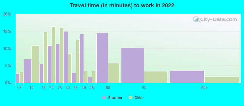
- Mean travel time to work (commute): 17.5 minutes


| Here: | 6.5 |
| Ohio average: | 11.0 |
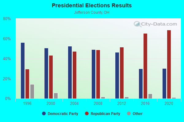
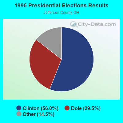
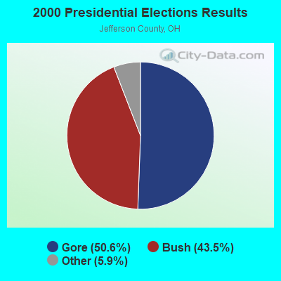
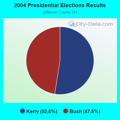
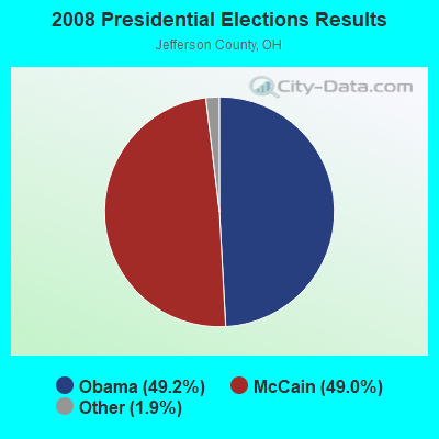
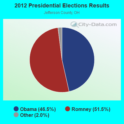


Graphs represent county-level data. Detailed 2008 Election Results
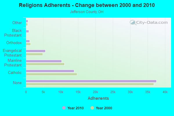
Religion statistics for Stratton, OH (based on Jefferson County data)
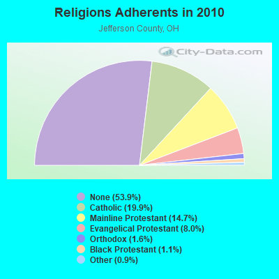
| Religion | Adherents | Congregations |
|---|---|---|
| Catholic | 13,851 | 16 |
| Mainline Protestant | 10,273 | 71 |
| Evangelical Protestant | 5,548 | 49 |
| Orthodox | 1,089 | 5 |
| Black Protestant | 796 | 7 |
| Other | 612 | 5 |
| None | 37,540 | - |
Food Environment Statistics:
| Here: | 3.05 / 10,000 pop. |
| Ohio: | 1.89 / 10,000 pop. |
| Here: | 0.15 / 10,000 pop. |
| State: | 0.13 / 10,000 pop. |
| Jefferson County: | 1.89 / 10,000 pop. |
| Ohio: | 1.25 / 10,000 pop. |
| Jefferson County: | 3.49 / 10,000 pop. |
| Ohio: | 2.93 / 10,000 pop. |
| Here: | 7.85 / 10,000 pop. |
| Ohio: | 6.25 / 10,000 pop. |
| Jefferson County: | 12.4% |
| Ohio: | 10.3% |
| This county: | 30.8% |
| State: | 29.1% |
| Here: | 10.4% |
| Ohio: | 11.9% |
Health and Nutrition:
| Here: | 45.1% |
| Ohio: | 50.4% |
| Here: | 47.9% |
| Ohio: | 47.8% |
| Stratton: | 26.8 |
| Ohio: | 28.7 |
| Stratton: | 19.0% |
| State: | 20.6% |
| Stratton: | 20.0% |
| State: | 10.4% |
| Stratton: | 7.2 |
| Ohio: | 6.8 |
| Here: | 28.9% |
| State: | 34.3% |
| Stratton: | 49.7% |
| State: | 57.0% |
| This city: | 84.2% |
| Ohio: | 79.1% |
More about Health and Nutrition of Stratton, OH Residents
| Local government employment and payroll (March 2022) | |||||
| Function | Full-time employees | Monthly full-time payroll | Average yearly full-time wage | Part-time employees | Monthly part-time payroll |
|---|---|---|---|---|---|
| Streets and Highways | 4 | $15,349 | $46,047 | 6 | $11,612 |
| Sewerage | 1 | $3,508 | $42,096 | 0 | $0 |
| Fire - Other | 0 | $0 | 6 | $3,986 | |
| Police Protection - Officers | 0 | $0 | 1 | $2,163 | |
| Totals for Government | 5 | $18,857 | $45,257 | 13 | $17,761 |
Stratton government finances - Expenditure in 2017 (per resident):
- Current Operations - Central Staff Services: $703,000 ($2693.49)
General - Other: $106,000 ($406.13)
Regular Highways: $103,000 ($394.64)
Parks and Recreation: $96,000 ($367.82)
Police Protection: $49,000 ($187.74)
Judicial and Legal Services: $30,000 ($114.94)
Financial Administration: $23,000 ($88.12)
Local Fire Protection: $15,000 ($57.47)
Water Utilities: $15,000 ($57.47)
Sewerage: $13,000 ($49.81)
- General - Interest on Debt: $25,000 ($95.79)
- Intergovernmental to Local - Other - Health - Other: $40,000 ($153.26)
- Other Capital Outlay - General - Other: $170,000 ($651.34)
- Total Salaries and Wages: $756,000 ($2896.55)
Stratton government finances - Revenue in 2017 (per resident):
- Charges - Sewerage: $8,000 ($30.65)
Other: $3,000 ($11.49)
- Federal Intergovernmental - Other: $21,000 ($80.46)
- Miscellaneous - General Revenue - Other: $4,000 ($15.33)
Interest Earnings: $3,000 ($11.49)
Fines and Forfeits: $1,000 ($3.83)
- Revenue - Water Utilities: $6,000 ($22.99)
- State Intergovernmental - General Local Government Support: $382,000 ($1463.60)
Highways: $6,000 ($22.99)
- Tax - Property: $793,000 ($3038.31)
Stratton government finances - Cash and Securities in 2017 (per resident):
- Bond Funds - Cash and Securities: $173,000 ($662.84)
- Other Funds - Cash and Securities: $17,000 ($65.13)
Strongest AM radio stations in Stratton:
- WWVA (1170 AM; 53 kW; WHEELING, WV; Owner: CAPSTAR TX LIMITED PARTNERSHIP)
- KDKA (1020 AM; 50 kW; PITTSBURGH, PA; Owner: INFINITY BROADCASTING OPERATIONS, INC.)
- WDIG (950 AM; 1 kW; STEUBENVILLE, OH; Owner: WORLD WITNESS FOR CHRIST MINIST.,INC)
- WEIR (1430 AM; 1 kW; WEIRTON, WV)
- WOHI (1490 AM; 1 kW; EAST LIVERPOOL, OH; Owner: KEYMARKET LICENSES, LLC)
- WWCS (540 AM; 5 kW; CANONSBURG, PA; Owner: BIRACH BROADCASTING CORPORATION)
- WKNR (850 AM; 50 kW; CLEVELAND, OH; Owner: CARON BROADCASTING, INC.)
- WTAM (1100 AM; 50 kW; CLEVELAND, OH; Owner: JACOR BROADCASTING CORPORATION)
- WKBN (570 AM; 5 kW; YOUNGSTOWN, OH; Owner: CITICASTERS LICENSES, L.P.)
- WHK (1220 AM; 50 kW; CLEVELAND, OH; Owner: CARON BROADCASTING, INC.)
- WPIT (730 AM; 5 kW; PITTSBURGH, PA; Owner: PENNSYLVANIA MEDIA ASSOCIATES, INC.)
- WHBC (1480 AM; 15 kW; CANTON, OH; Owner: NM LICENSING, LLC)
- WSTV (1340 AM; 1 kW; STEUBENVILLE, OH; Owner: KEYMARKET LICENSES, LLC)
Strongest FM radio stations in Stratton:
- WOGH (103.5 FM; BURGETTSTOWN, PA; Owner: KEYMARKET LICENSES, LLC)
- WOGF (104.3 FM; EAST LIVERPOOL, OH; Owner: KEYMARKET LICENSES, LLC)
- W215BC (90.9 FM; STEUBENVILLE, OH; Owner: PENSACOLA CHRISTIAN COLLEGE, INC.)
- WMXY (98.9 FM; YOUNGSTOWN, OH; Owner: CITICASTERS LICENSES, L.P.)
- WQXK (105.1 FM; SALEM, OH; Owner: CUMULUS LICENSING CORP.)
- WBJV (88.9 FM; STEUBENVILLE, OH; Owner: AMERICAN FAMILY ASSOCIATION)
- WSHH (99.7 FM; PITTSBURGH, PA; Owner: RENDA B/CING CORP. OF NEVADA)
- WAMO-FM (106.7 FM; BEAVER FALLS, PA; Owner: MCL/MCM-INC)
- WLTJ (92.9 FM; PITTSBURGH, PA; Owner: WPNT, INC.)
- WOVK (98.7 FM; WHEELING, WV; Owner: CAPSTAR TX LIMITED PARTNERSHIP)
- WEGW (107.5 FM; WHEELING, WV; Owner: CAPSTAR TX LIMITED PARTNERSHIP)
- WVNP (89.9 FM; WHEELING, WV; Owner: WEST VIRGINIA EDUCATIONAL BROADCASTING AUTHORITY)
- WDVE (102.5 FM; PITTSBURGH, PA; Owner: CAPSTAR TX LIMITED PARTNERSHIP)
- WJJJ (104.7 FM; PITTSBURGH, PA; Owner: CAPSTAR TX LIMITED PARTNERSHIP)
- WDSY-FM (107.9 FM; PITTSBURGH, PA; Owner: INFINITY RADIO SUBSIDIARY OPERATIONS INC.)
- WWSW-FM (94.5 FM; PITTSBURGH, PA; Owner: AMFM RADIO LICENSES, L.L.C.)
- WZPT (100.7 FM; NEW KENSINGTON, PA; Owner: INFINITY RADIO SUBSIDIARY OPERATIONS INC.)
- WCDK (106.3 FM; CADIZ, OH; Owner: PRIORITY COMMUNICATIONS OHIO, LLC)
- WVBC (88.1 FM; BETHANY, WV; Owner: BETHANY COLLEGE)
- WEEL (95.7 FM; SHADYSIDE, OH; Owner: OHIO VALLEY COMMUNICATIONS, INC.)
TV broadcast stations around Stratton:
- W25CI (Channel 25; STEUBENVILLE, OH; Owner: ABACUS TELEVISION)
- W57BH (Channel 57; WEIRTON, WV; Owner: TURNPIKE TELEVISION)
- WTOV-TV (Channel 9; STEUBENVILLE, OH; Owner: WTOV-TV HOLDINGS, INC.)
- WKBN-TV (Channel 27; YOUNGSTOWN, OH; Owner: PIEDMONT TELEVISION OF YOUNGSTOWN LICENSE LLC)
- WPXI (Channel 11; PITTSBURGH, PA; Owner: WPXI-TV HOLDINGS, INC.)
- WTRF-TV (Channel 7; WHEELING, WV; Owner: WEST VIRGINIA MEDIA HOLDINGS, LLC)
- W66BQ (Channel 66; BEAVER, PA; Owner: BRUNO-GOODWORTH NETWORK, INC.)
- KDKA-TV (Channel 2; PITTSBURGH, PA; Owner: CBS BROADCASTING INC.)
- WFMJ-TV (Channel 21; YOUNGSTOWN, OH; Owner: WFMJ TELEVISION, INC.)
- WNEO (Channel 45; ALLIANCE, OH; Owner: NORTHEASTERN EDUCATIONAL TELEVISION OF OHIO, INC.)
- WBGN-LP (Channel 59; PITTSBURGH, PA; Owner: BRUNO GOODWORTH NETWORK, INC.)
- WPTG-LP (Channel 69; PITTSBURGH, PA; Owner: ABACUS TELEVISION)
- WDLI (Channel 17; CANTON, OH; Owner: TRINITY BROADCASTING NETWORK, INC.)
- WOUC-TV (Channel 44; CAMBRIDGE, OH; Owner: OHIO UNIVERSITY)
- WQEX (Channel 16; PITTSBURGH, PA; Owner: WQED MULTIMEDIA)
- WPGH-TV (Channel 53; PITTSBURGH, PA; Owner: WPGH LICENSEE, LLC)
- W65CG (Channel 65; PITTSBURGH, PA; Owner: TRINITY BROADCASTING NETWORK)
- WYFX-LP (Channel 62; YOUNGSTOWN, OH; Owner: PIEDMONT TELEVISION OF YOUNGSTOWN LICENSE LLC)
- WBPA-LP (Channel 29; PITTSBURGH, PA; Owner: VENTURE TECHNOLOGIES GROUP, LLC)
Stratton fatal accident list:
- National Bridge Inventory (NBI) Statistics
- 44Number of bridges
- 597ft / 182mTotal length
- $4,430,000Total costs
- 479,719Total average daily traffic
- 70,249Total average daily truck traffic

- New bridges - historical statistics
- 11920-1929
- 31930-1939
- 21940-1949
- 71950-1959
- 261960-1969
- 31980-1989
- 11990-1999
- 12010-2019
FCC Registered Antenna Towers:
3- Darryl L Anderson, 431 Township Rd 250 (Lat: 40.524167 Lon: -80.646583), Type: 101.5, Overall height: 97.5 m, Registrant: State Of Ohio Department Of Admin. Serv, Colum-bus, Phone: (614) 995-0060
- Darryl L Anderson, 431 Township Rd 250 (Lat: 40.524167 Lon: -80.646583), Type: 101.5, Overall height: 97.5 m, Registrant: Paul.Mayer@das.State.Oh.Us, , Colum-bus, Phone: (614) 995-0063
- DARRYL L ANDERSON, 431 Township Rd 250 (Lat: 40.524167 Lon: -80.646583), Type: 101.5, Structure height: 39081 m, Overall height: 97.5 m, Registrant: State Of Ohio, Bob.Bill@das.Ohio.Gov, , Colum-bus, Phone: (614) 995-0063
FCC Registered Broadcast Land Mobile Towers:
7- 2.9 Mi W (Lat: 40.515889 Lon: -80.659250), Structure height: 58 m, Call Sign: WNJT252, Licensee ID: L00265137,
Assigned Frequencies: 451.300 MHz, Grant Date: 07/14/1997, Expiration Date: 07/14/2002, Cancellation Date: 11/17/2002, Certifier: R Dean Meiszer, Registrant: Lb Tower Company LLC, 441 Vine Street, Suite 3900, Cincinnati, OH 45202-3011, Phone: (513) 381-7775, Fax: (513) 381-1292
- Sammis Power Plant Rt 7 (Lat: 40.530889 Lon: -80.630917), Type: Building, Structure height: 47 m, Call Sign: KNIA372,
Assigned Frequencies: 451.050 MHz, 461.025 MHz, 461.025 MHz, Grant Date: 12/28/2013, Expiration Date: 01/18/2024, Cancellation Date: 08/01/2023, Certifier: Jay Bellingham, Registrant: Akin Gump Strauss Hauer & Feld LLP, 2001 K St Nw, Washington, DC 20006, Phone: (202) 887-4524, Email:
- Sammis Power Plant Rt 7 (Lat: 40.532556 Lon: -80.631472), Call Sign: KNIA373,
Assigned Frequencies: 451.050 MHz, Grant Date: 12/28/2013, Expiration Date: 01/18/2024, Cancellation Date: 08/01/2023, Certifier: Jay Bellingham, Registrant: Akin Gump Strauss Hauer & Feld LLP, 2001 K Street Northwest, Washington, DC 20006, Phone: (202) 887-4524, Email:
- 3l251 Edison Rd Rt 1 (Lat: 40.528667 Lon: -80.644250), Call Sign: KUC236, Licensee ID: L00288741,
Assigned Frequencies: 451.275 MHz, Grant Date: 02/16/1999, Expiration Date: 02/16/2004, Cancellation Date: 04/25/2004, Registrant: Felhc Inc, 76 South Main Street, Akron, OH 44308, Phone: (330) 384-5498
- Oh-7 (Lat: 40.529167 Lon: -80.631667), Call Sign: WPSM933,
Assigned Frequencies: 451.512 MHz, 456.512 MHz, Grant Date: 06/08/2021, Expiration Date: 06/25/2031, Certifier: Dennis G Macrae, Registrant: Dte Energy Company, 1 Energy Plz, Detroit, MI 48226, Phone: (313) 235-9713, Fax: (513) 794-1276, Email:
- Lat: 40.525000 Lon: -80.630222, Call Sign: WQGQ792,
Assigned Frequencies: 451.687 MHz, 452.250 MHz, 462.037 MHz, 452.487 MHz, 463.262 MHz, 452.887 MHz, 456.562 MHz, 456.687 MHz, 457.250 MHz, 467.037 MHz... (+5 more), Grant Date: 03/27/2007, Expiration Date: 03/27/2017, Cancellation Date: 05/27/2017, Certifier: Dwayne Thomas, Registrant: Ewa / Lao, 102 East Middle St, Gettysburg, PA 17325-1938, Phone: (800) 886-4222, Fax: (717) 337-1479, Email:
- MOBILES L4, Lat: 40.543139 Lon: -80.638694, Call Sign: WQTC517, Licensee ID: L00008014,
Assigned Frequencies: 160.800 MHz, 161.070 MHz, 160.860 MHz, 160.980 MHz, 161.130 MHz, Grant Date: 10/19/2023, Expiration Date: 01/06/2034, Certifier: Jerry R Celio, Registrant: Norfolk Southern Railway Company, 650 West Peachtree St, Nw, Box 41, Atlanta, GA 30308, Phone: (404) 660-4050, Email:
FCC Registered Microwave Towers:
3- MARCS STRATT, 431 Township Rd 250 (Lat: 40.524167 Lon: -80.646583), Type: Tower, Structure height: 97.5 m, Overall height: 101.5 m, Call Sign: WQNS294,
Assigned Frequencies: 19345.0 MHz, 19345.0 MHz, 19345.0 MHz, 19345.0 MHz, 19345.0 MHz, 19345.0 MHz, 19345.0 MHz, Grant Date: 02/06/2021, Expiration Date: 05/05/2031, Certifier: Rob Herrington, Registrant: Jefferson County 911, 300 Airport Road, Wintersville, OH 43953, Phone: (740) 266-4150, Fax: (740) 266-4238, Email:
- OH081BZ02, 431 Township Rd 250 (Lat: 40.524167 Lon: -80.646583), Type: Ltower, Structure height: 97.5 m, Overall height: 101.5 m, Call Sign: WSAF630,
Assigned Frequencies: 19540.0 MHz, 19540.0 MHz, 19540.0 MHz, 19540.0 MHz, 19540.0 MHz, 19540.0 MHz, 19540.0 MHz, 19540.0 MHz, 19540.0 MHz, 19540.0 MHz... (+38 more), Grant Date: 01/12/2024, Expiration Date: 01/12/2034, Certifier: Rob Contrael, Registrant: Agile Networks, 213 Market Ave N, Suite 310, Canton, OH 44702, Phone: (888) 494-0549, Email:
- STRATTON, 2.9 Miles W Of (Lat: 40.515889 Lon: -80.659222), Overall height: 59.7 m, Call Sign: WHQ621, Licensee ID: L00265137,
Assigned Frequencies: 6197.20 MHz, 6226.90 MHz, 6226.90 MHz, 6197.20 MHz, 6256.50 MHz, 6286.20 MHz, 6286.20 MHz, 6256.50 MHz, 6315.90 MHz, 6345.50 MHz... (+6 more), Grant Date: 02/21/2001, Expiration Date: 02/01/2011, Cancellation Date: 04/09/2011, Certifier: R D Meiszer, Registrant: Lb Tower Company LLC, 441 Vine Street, Suite 3900, Cincinnati, OH 45202-3011, Phone: (513) 381-7775, Fax: (513) 381-1292
FCC Registered Amateur Radio Licenses:
1- Call Sign: N8QPQ, Licensee ID: L00398179, Grant Date: 10/30/2021, Expiration Date: 10/30/2031, Registrant: Michael R Wilson, 121 2nd Ave Box 93, Stratton, OH 43961-0231
| Most common first names in Stratton, OH among deceased individuals | ||
| Name | Count | Lived (average) |
|---|---|---|
| John | 9 | 78.2 years |
| William | 8 | 75.3 years |
| Mary | 6 | 75.8 years |
| Frank | 4 | 80.5 years |
| Robert | 4 | 57.2 years |
| Joseph | 3 | 74.7 years |
| Julia | 3 | 88.0 years |
| Mike | 3 | 84.7 years |
| Paul | 3 | 72.0 years |
| Walter | 3 | 67.6 years |
| Most common last names in Stratton, OH among deceased individuals | ||
| Last name | Count | Lived (average) |
|---|---|---|
| Byers | 7 | 77.4 years |
| Rudder | 5 | 75.0 years |
| Martin | 4 | 70.2 years |
| Mihalik | 4 | 77.2 years |
| Smith | 4 | 67.0 years |
| Maydak | 3 | 77.7 years |
| Racz | 3 | 79.0 years |
| Rohal | 3 | 85.3 years |
| Thomas | 3 | 68.6 years |
| Treadway | 3 | 78.3 years |
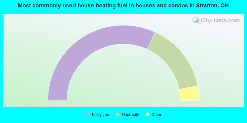
- 64.7%Utility gas
- 30.4%Electricity
- 3.9%Bottled, tank, or LP gas
- 1.0%Fuel oil, kerosene, etc.
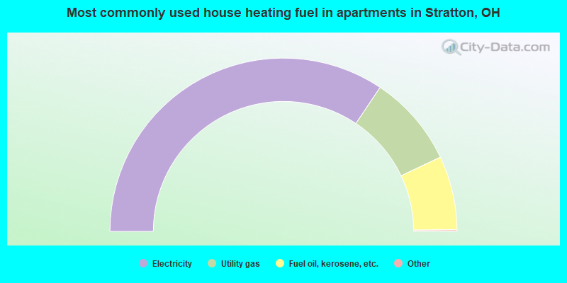
- 69.0%Electricity
- 17.2%Utility gas
- 13.8%Fuel oil, kerosene, etc.
Stratton compared to Ohio state average:
- Median household income below state average.
- Median house value significantly below state average.
- Unemployed percentage below state average.
- Black race population percentage significantly below state average.
- Hispanic race population percentage below state average.
- Median age significantly above state average.
- Foreign-born population percentage significantly below state average.
- Length of stay since moving in significantly above state average.
- Percentage of population with a bachelor's degree or higher significantly below state average.