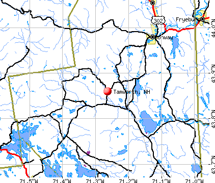
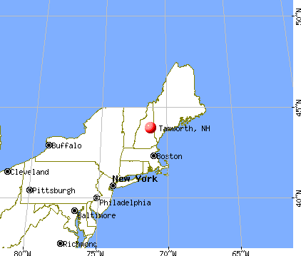
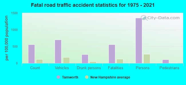
Tamworth, New Hampshire
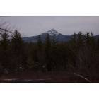
Tamworth: Chocorua Mt.
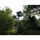
Tamworth: Fire Tower on Great Hill Road
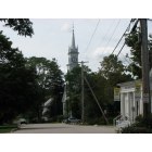
Tamworth: Downtown Tamworth Village

Tamworth: Sunset in Tamworth Village
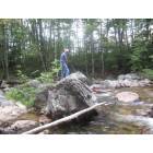
Tamworth: Swift River
- add
your


Submit your own pictures of this town and show them to the world
- OSM Map
- General Map
- Google Map
- MSN Map
Population change since 2000: +13.8%
 |
| Males: 1,413 | |
| Females: 1,443 |
| Median resident age: | 47.6 years |
| New Hampshire median age: | 43.9 years |
Zip codes: 03886.
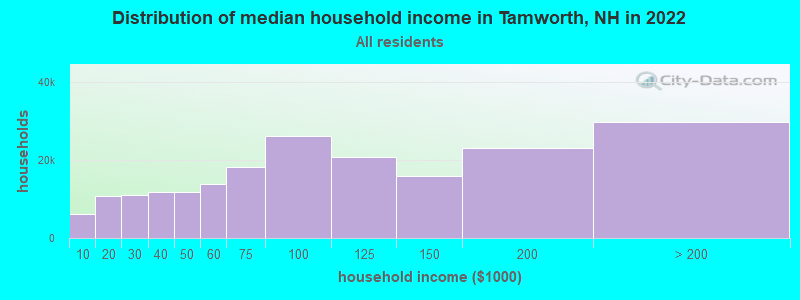
| Tamworth: | $67,183 |
| NH: | $89,992 |
Estimated per capita income in 2022: $40,317 (it was $17,961 in 2000)
Tamworth town income, earnings, and wages data
Estimated median house or condo value in 2022: $302,876 (it was $99,000 in 2000)
| Tamworth: | $302,876 |
| NH: | $384,700 |
Mean prices in 2022: all housing units: $505,201; detached houses: $542,950; townhouses or other attached units: $363,532; in 2-unit structures: $373,773; in 3-to-4-unit structures: $587,160; in 5-or-more-unit structures: $313,992; mobile homes: $113,714; occupied boats, rvs, vans, etc.: $118,400
Detailed information about poverty and poor residents in Tamworth, NH


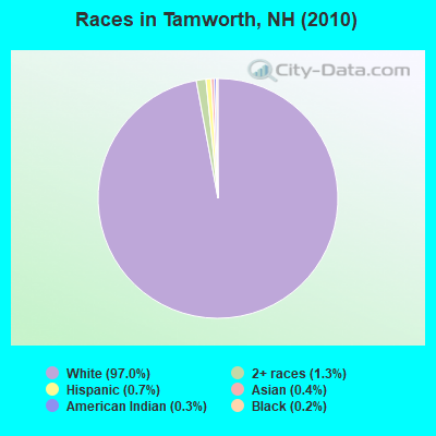
- 2,77197.0%White alone
- 371.3%Two or more races
- 210.7%Hispanic
- 110.4%Asian alone
- 90.3%American Indian alone
- 70.2%Black alone
Races in Tamworth detailed stats: ancestries, foreign born residents, place of birth
According to our research of New Hampshire and other state lists, there were 9 registered sex offenders living in Tamworth, New Hampshire as of May 21, 2024.
The ratio of all residents to sex offenders in Tamworth is 317 to 1.
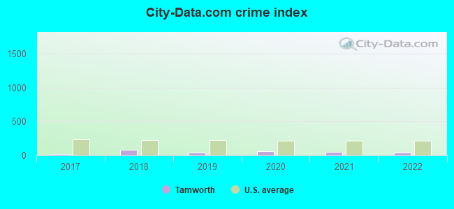
Type |
2017 |
2018 |
2019 |
2020 |
2021 |
2022 |
|---|---|---|---|---|---|---|
| Murders (per 100,000) | 0 (0.0) | 0 (0.0) | 0 (0.0) | 0 (0.0) | 0 (0.0) | 0 (0.0) |
| Rapes (per 100,000) | 0 (0.0) | 2 (66.5) | 0 (0.0) | 0 (0.0) | 1 (32.1) | 0 (0.0) |
| Robberies (per 100,000) | 0 (0.0) | 0 (0.0) | 1 (32.5) | 0 (0.0) | 0 (0.0) | 0 (0.0) |
| Assaults (per 100,000) | 1 (34.3) | 1 (33.2) | 1 (32.5) | 2 (64.5) | 1 (32.1) | 1 (33.9) |
| Burglaries (per 100,000) | 0 (0.0) | 2 (66.5) | 0 (0.0) | 0 (0.0) | 1 (32.1) | 2 (67.8) |
| Thefts (per 100,000) | 11 (377.6) | 17 (565.0) | 12 (390.0) | 26 (838.4) | 15 (481.2) | 23 (779.9) |
| Auto thefts (per 100,000) | 0 (0.0) | 0 (0.0) | 2 (65.0) | 4 (129.0) | 0 (0.0) | 0 (0.0) |
| Arson (per 100,000) | 0 (0.0) | 1 (33.2) | 0 (0.0) | 0 (0.0) | 0 (0.0) | 0 (0.0) |
| City-Data.com crime index | 22.0 | 87.1 | 37.0 | 56.8 | 53.6 | 42.7 |
The City-Data.com crime index weighs serious crimes and violent crimes more heavily. Higher means more crime, U.S. average is 246.1. It adjusts for the number of visitors and daily workers commuting into cities.
Crime rate in Tamworth detailed stats: murders, rapes, robberies, assaults, burglaries, thefts, arson
Full-time law enforcement employees in 2021, including police officers: 2 (2 officers - 1 male; 1 female).
| Officers per 1,000 residents here: | 0.64 |
| New Hampshire average: | 2.14 |
 Recent articles from our blog. Our writers, many of them Ph.D. graduates or candidates, create easy-to-read articles on a wide variety of topics.


 | First visit to NH (28 replies) |
| Relocating from FL to NH (65 replies) |
| Towns with excessive or lax zoning regulations (32 replies) |
| Info on Tamworth (19 replies) |
| Looking For A Great Real Estate Attorney - Tamworth (1 reply) |
| Country (2019 replies) |
Latest news from Tamworth, NH collected exclusively by city-data.com from local newspapers, TV, and radio stations
Ancestries: English (33.1%), Irish (18.8%), French (17.8%), German (10.7%), United States (8.8%), Scottish (8.5%).
Current Local Time: EST time zone
Incorporated in 1766
Elevation: 524 feet
Land area: 59.9 square miles.
Population density: 48 people per square mile (very low).
39 residents are foreign born
| This town: | 1.6% |
| New Hampshire: | 4.4% |
| Tamworth town: | 1.8% ($1,797) |
| New Hampshire: | 2.3% ($2,946) |
Nearest city with pop. 50,000+: Portland, ME  (50.7 miles , pop. 64,249).
Nearest city with pop. 200,000+: Boston, MA (106.9 miles , pop. 589,141).
Nearest city with pop. 1,000,000+: Bronx, NY (248.0 miles , pop. 1,332,650).
Nearest cities:
), ), ), ), ), Latitude: 43.86 N, Longitude: 71.25 W
Area code: 603

| Here: | 2.7% |
| New Hampshire: | 2.5% |
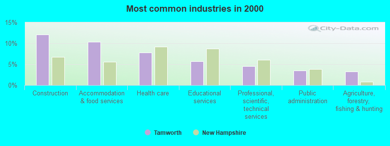
- Construction (12.1%)
- Accommodation & food services (10.4%)
- Health care (7.8%)
- Educational services (5.7%)
- Professional, scientific, technical services (4.5%)
- Public administration (3.5%)
- Agriculture, forestry, fishing & hunting (3.3%)
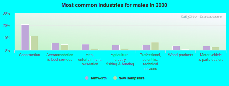
- Construction (21.0%)
- Accommodation & food services (6.0%)
- Arts, entertainment, recreation (4.8%)
- Agriculture, forestry, fishing & hunting (4.5%)
- Professional, scientific, technical services (4.3%)
- Wood products (3.7%)
- Motor vehicle & parts dealers (3.6%)
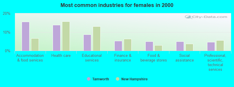
- Accommodation & food services (15.6%)
- Health care (13.8%)
- Educational services (8.7%)
- Finance & insurance (5.2%)
- Food & beverage stores (4.9%)
- Social assistance (4.9%)
- Professional, scientific, technical services (4.7%)
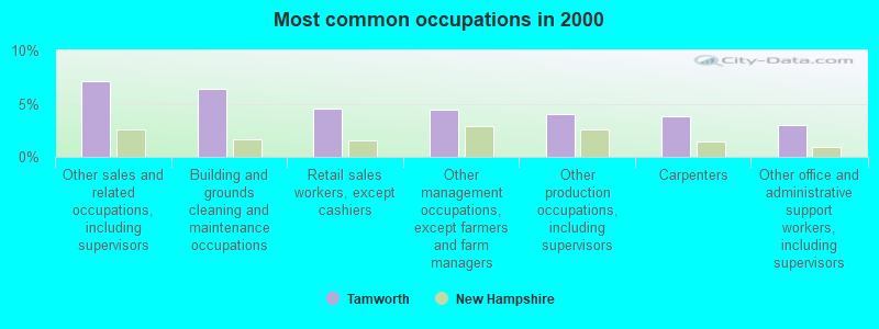
- Other sales and related occupations, including supervisors (7.1%)
- Building and grounds cleaning and maintenance occupations (6.4%)
- Retail sales workers, except cashiers (4.5%)
- Other management occupations, except farmers and farm managers (4.4%)
- Other production occupations, including supervisors (4.0%)
- Carpenters (3.9%)
- Other office and administrative support workers, including supervisors (3.0%)
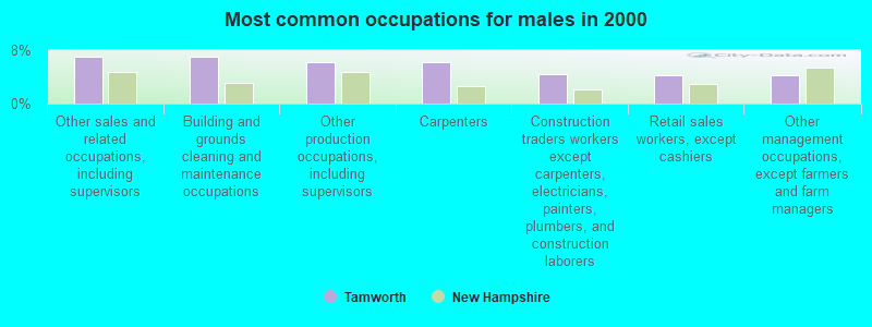
- Other sales and related occupations, including supervisors (7.0%)
- Building and grounds cleaning and maintenance occupations (7.0%)
- Other production occupations, including supervisors (6.3%)
- Carpenters (6.3%)
- Construction traders workers except carpenters, electricians, painters, plumbers, and construction laborers (4.5%)
- Retail sales workers, except cashiers (4.3%)
- Other management occupations, except farmers and farm managers (4.3%)
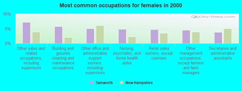
- Other sales and related occupations, including supervisors (7.2%)
- Building and grounds cleaning and maintenance occupations (5.8%)
- Other office and administrative support workers, including supervisors (5.1%)
- Nursing, psychiatric, and home health aides (4.9%)
- Retail sales workers, except cashiers (4.7%)
- Other management occupations, except farmers and farm managers (4.5%)
- Secretaries and administrative assistants (3.8%)
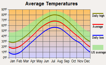
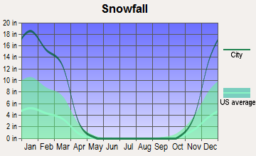
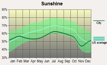
Average climate in Tamworth, New Hampshire
Based on data reported by over 4,000 weather stations
(lower is better)
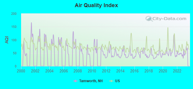
Air Quality Index (AQI) level in 2022 was 46.9. This is significantly better than average.
| City: | 46.9 |
| U.S.: | 72.6 |
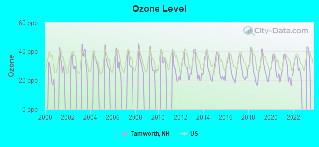
Ozone [ppb] level in 2022 was 29.8. This is about average. Closest monitor was 9.9 miles away from the city center.
| City: | 29.8 |
| U.S.: | 33.3 |
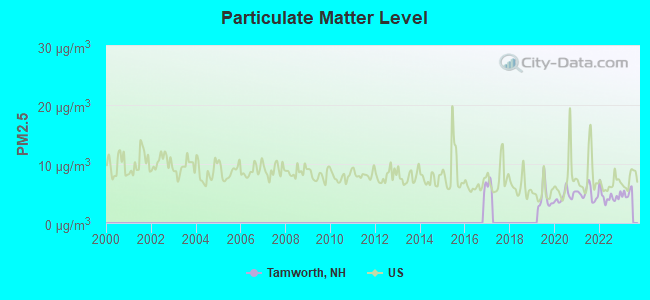
Particulate Matter (PM2.5) [µg/m3] level in 2022 was 4.52. This is significantly better than average. Closest monitor was 21.8 miles away from the city center.
| City: | 4.52 |
| U.S.: | 8.11 |
Tornado activity:
Tamworth-area historical tornado activity is below New Hampshire state average. It is 72% smaller than the overall U.S. average.
On 7/18/1963, a category F2 (max. wind speeds 113-157 mph) tornado 18.3 miles away from the Tamworth town center caused between $5000 and $50,000 in damages.
On 6/22/1981, a category F2 tornado 30.2 miles away from the town center caused between $500,000 and $5,000,000 in damages.
Earthquake activity:
Tamworth-area historical earthquake activity is significantly above New Hampshire state average. It is 72% smaller than the overall U.S. average.On 4/20/2002 at 10:50:47, a magnitude 5.3 (5.3 ML, Depth: 3.0 mi, Class: Moderate, Intensity: VI - VII) earthquake occurred 129.5 miles away from the city center
On 4/20/2002 at 10:50:47, a magnitude 5.2 (5.2 MB, 4.2 MS, 5.2 MW, 5.0 MW) earthquake occurred 129.9 miles away from Tamworth center
On 10/7/1983 at 10:18:46, a magnitude 5.3 (5.1 MB, 5.3 LG, 5.1 ML) earthquake occurred 154.3 miles away from Tamworth center
On 1/19/1982 at 00:14:42, a magnitude 4.7 (4.5 MB, 4.7 MD, 4.5 LG, Class: Light, Intensity: IV - V) earthquake occurred 30.7 miles away from Tamworth center
On 10/16/2012 at 23:12:25, a magnitude 4.7 (4.7 ML, Depth: 10.0 mi) earthquake occurred 34.8 miles away from Tamworth center
On 8/21/1996 at 07:54:14, a magnitude 3.8 (3.8 LG, 3.6 LG, Depth: 6.2 mi, Class: Light, Intensity: II - III) earthquake occurred 22.8 miles away from the city center
Magnitude types: regional Lg-wave magnitude (LG), body-wave magnitude (MB), duration magnitude (MD), local magnitude (ML), surface-wave magnitude (MS), moment magnitude (MW)
Natural disasters:
The number of natural disasters in Carroll County (29) is a lot greater than the US average (15).Major Disasters (Presidential) Declared: 17
Emergencies Declared: 9
Causes of natural disasters: Storms: 12, Floods: 11, Winter Storms: 5, Hurricanes: 4, Snows: 4, Snowstorms: 2, Blizzard: 1, Heavy Rain: 1, Ice Storm: 1, Snowfall: 1, Tornado: 1, Tropical Storm: 1, Wind: 1, Other: 1 (Note: some incidents may be assigned to more than one category).
Hospitals and medical centers near Tamworth:
- MOULTONBORO VNS (Home Health Center, about 11 miles away; MOULTONBOROUGH, NH)
- MERRIMAN HOUSE (Nursing Home, about 12 miles away; NORTH CONWAY, NH)
- MINERAL SPRINGS OF NORTH CONWAY CARE AND REHABILIT (Nursing Home, about 12 miles away; NORTH CONWAY, NH)
- MOUNTAIN VIEW NURSING HOME (Nursing Home, about 14 miles away; OSSIPEE, NH)
- VN AND HSP CARE SVC OF N CAR CTY (Home Health Center, about 15 miles away; NORTH CONWAY, NH)
Colleges/universities with over 2000 students nearest to Tamworth:
- Plymouth State University (about 24 miles; Plymouth, NH; Full-time enrollment: 4,838)
- Saint Joseph's College of Maine (about 39 miles; Standish, ME; FT enrollment: 2,010)
- NHTI-Concord's Community College (about 47 miles; Concord, NH; FT enrollment: 2,865)
- University of Southern Maine (about 51 miles; Portland, ME; FT enrollment: 6,647)
- University of New England (about 52 miles; Biddeford, ME; FT enrollment: 4,539)
- University of New Hampshire-Main Campus (about 53 miles; Durham, NH; FT enrollment: 15,243)
- Southern Maine Community College (about 54 miles; South Portland, ME; FT enrollment: 4,666)
Public elementary/middle school in Tamworth:
- KENNETH A. BRETT SCHOOL (Students: 237, Location: 881 TAMWORTH RD., Grades: KG-8)
Library in Tamworth:
Points of interest:
Notable locations in Tamworth: White Mountain Camp (A), Camp Hemenway (B), Campground Number 1 (C), Campground Number 2 (D), Campground Number 3 (E), White Lake Camping Ground (F), Chocorua Village Station (G), Tamworth Fire Department Wonalancet Station (H), Tamworth Fire Department (I), Tamworth Fire Department Central Station (J), Tamworth Rescue Squad (K). Display/hide their locations on the map
Cemeteries: Riverside Cemetery (1), Stevenson Cemetery (2). Display/hide their locations on the map
Lakes and reservoirs: James Pond (A), Beaver Pond (B), Tilton Pond (C), White Lake (D), Little Lake (E), Jackman Pond (F), Lonely Lake (G), Moores Pond (H). Display/hide their locations on the map
Streams, rivers, and creeks: Wonalancet River (A), Swift River (B), Durrell Brook (C), Deer Brook (D), Sanborn Brook (E), Sanger Brook (F), Paugus Brook (G), Meadow Brook (H), Lord Brook (I). Display/hide their locations on the map
Parks in Tamworth include: Bowditch-Runnells State Forest (1), White Lake State Park (2). Display/hide their locations on the map
Tourist attraction: White Lake Speedway - Go-Karts & Mini Golf Fun Park (Amusement & Theme Parks; Route 16) (1). Display/hide its approximate location on the map
Hotel: Whispering Pines B&B (Route 113A & Hemenway Road) (1). Display/hide its approximate location on the map
Birthplace of: Jonathan P. Folsom - Politician, Rosy Lamb - Artist.
Drinking water stations with addresses in Tamworth and their reported violations in the past:
WHITE LAKE INN AND TAVERN (Population served: 250, Groundwater):Past health violations:RIVERBEND CAMPGROUND (Population served: 75, Groundwater):Past monitoring violations:
- MCL, Monthly (TCR) - Between JUL-2006 and SEP-2006, Contaminant: Coliform. Follow-up actions: St Public Notif requested (SEP-06-2006), St Violation/Reminder Notice (SEP-06-2006), St Formal NOV issued (SEP-19-2006), St Public Notif received (APR-23-2007), St Compliance achieved (MAY-31-2007)
- MCL, Monthly (TCR) - Between APR-2005 and JUN-2005, Contaminant: Coliform. Follow-up actions: St Public Notif requested (JUN-23-2005), St Violation/Reminder Notice (JUN-23-2005), St Public Notif received (SEP-12-2005), St Compliance achieved (MAY-30-2006), St Formal NOV issued (SEP-19-2006)
- Monitoring, Source Water (GWR) - Between NOV-23-2011 and DEC-23-2011, Contaminant: E. COLI. Follow-up actions: St Public Notif requested (DEC-21-2011), St Violation/Reminder Notice (DEC-21-2011), St Public Notif received (FEB-28-2012), St Compliance achieved (MAR-05-2012)
- Monitoring, Repeat Major (TCR) - Between OCT-2011 and DEC-2011, Contaminant: Coliform (TCR). Follow-up actions: St Public Notif requested (DEC-21-2011), St Violation/Reminder Notice (DEC-21-2011), St Public Notif received (FEB-28-2012), St Compliance achieved (MAR-01-2012)
- 9 routine major monitoring violations
Past monitoring violations:RIVERSIDE LANDING (Population served: 44, Groundwater):
- One routine major monitoring violation
Past monitoring violations:REMICK CNTRY DR HARKNESS HOUSE (Population served: 25, Groundwater):
- 2 routine major monitoring violations
- One regular monitoring violation
Past health violations:TAMWORTH CAMPING AREA/REC BARN (Population served: 25, Groundwater):
- MCL, Monthly (TCR) - Between OCT-2011 and DEC-2011, Contaminant: Coliform. Follow-up actions: St Public Notif requested (DEC-27-2011), St Violation/Reminder Notice (DEC-27-2011), St Public Notif received (JAN-18-2012), St Compliance achieved (JUL-19-2012)
Past health violations:Past monitoring violations:
- MCL, Monthly (TCR) - Between OCT-2009 and DEC-2009, Contaminant: Coliform. Follow-up actions: St Public Notif requested (OCT-27-2009), St Violation/Reminder Notice (OCT-27-2009), St Public Notif received (DEC-02-2009), St Compliance achieved (AUG-16-2010)
- MCL, Monthly (TCR) - Between JUL-2009 and SEP-2009, Contaminant: Coliform. Follow-up actions: St Violation/Reminder Notice (AUG-05-2009), St Public Notif requested (AUG-05-2009), St Formal NOV issued (OCT-07-2009), St Public Notif received (OCT-20-2009), St Compliance achieved (AUG-16-2010)
- MCL, Monthly (TCR) - Between OCT-2008 and DEC-2008, Contaminant: Coliform. Follow-up actions: St Violation/Reminder Notice (NOV-06-2008), St Public Notif requested (NOV-06-2008), St Public Notif received (DEC-02-2008), St Compliance achieved (AUG-16-2010)
- MCL, Monthly (TCR) - Between JUL-2008 and SEP-2008, Contaminant: Coliform. Follow-up actions: St Public Notif requested (AUG-19-2008), St Violation/Reminder Notice (AUG-19-2008), St Formal NOV issued (AUG-25-2008), St Public Notif received (OCT-24-2008), St Compliance achieved (AUG-16-2010)
- MCL, Monthly (TCR) - Between OCT-2007 and DEC-2007, Contaminant: Coliform. Follow-up actions: St Public Notif requested (OCT-30-2007), St Violation/Reminder Notice (OCT-30-2007), St Public Notif received (JAN-11-2008), St Compliance achieved (JUN-04-2008)
- MCL, Monthly (TCR) - Between JUL-2007 and SEP-2007, Contaminant: Coliform. Follow-up actions: St Public Notif requested (SEP-25-2007), St Violation/Reminder Notice (SEP-25-2007), St Public Notif received (OCT-23-2007), St Compliance achieved (JUN-04-2008)
- 2 other older health violations
- Monitoring, Repeat Major (TCR) - Between OCT-2011 and DEC-2011, Contaminant: Coliform (TCR). Follow-up actions: St Public Notif requested (MAY-22-2012), St Violation/Reminder Notice (MAY-22-2012), St Compliance achieved (MAY-29-2012), St Public Notif received (JUL-12-2012)
- Monitoring, Repeat Major (TCR) - Between OCT-2008 and DEC-2008, Contaminant: Coliform (TCR). Follow-up actions: St Public Notif requested (JAN-05-2009), St Violation/Reminder Notice (JAN-05-2009), St Compliance achieved (MAY-28-2009), St Public Notif received (MAY-29-2009)
- Monitoring, Repeat Major (TCR) - Between JUL-2008 and SEP-2008, Contaminant: Coliform (TCR). Follow-up actions: St Public Notif requested (DEC-09-2008), St Violation/Reminder Notice (DEC-09-2008), St Compliance achieved (MAY-28-2009), St Public Notif received (MAY-29-2009)
- 3 routine major monitoring violations
Drinking water stations with addresses in Tamworth that have no violations reported:
- ROSIES RESTAURANT (Population served: 150, Primary Water Source Type: Groundwater)
- TAMWORTH CAMPING AREA/SITE 49 (Population served: 138, Primary Water Source Type: Groundwater)
- TAMWORTH CAMPING AREA/SITE 5 (Population served: 100, Primary Water Source Type: Groundwater)
- REMICK COUNTRY DR MUSEUM/FARM (Population served: 25, Primary Water Source Type: Groundwater)
| This town: | 2.2 people |
| New Hampshire: | 2.5 people |
| This town: | 59.6% |
| Whole state: | 66.3% |
| This town: | 10.0% |
| Whole state: | 8.3% |
Likely homosexual households (counted as self-reported same-sex unmarried-partner households)
- Lesbian couples: 0.5% of all households
- Gay men: 0.5% of all households
| This town: | 9.5% |
| Whole state: | 6.5% |
| This town: | 3.3% |
| Whole state: | 2.8% |
2 people in homes or halfway houses for drug/alcohol abuse in 2000
For population 15 years and over in Tamworth:
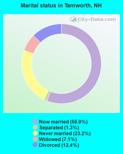
- Never married: 23.2%
- Now married: 55.9%
- Separated: 1.3%
- Widowed: 7.1%
- Divorced: 12.4%
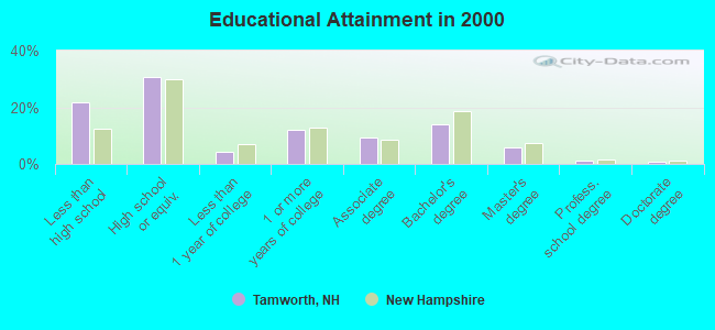
For population 25 years and over in Tamworth:
- High school or higher: 78.3%
- Bachelor's degree or higher: 22.3%
- Graduate or professional degree: 8.2%
- Unemployed: 5.5%
- Mean travel time to work (commute): 25.6 minutes
| Here: | 11.2 |
| New Hampshire average: | 10.9 |
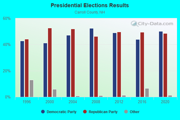
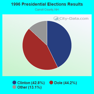
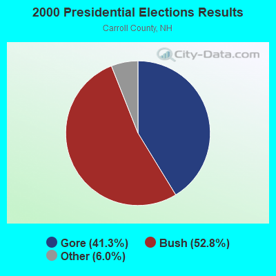

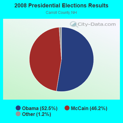
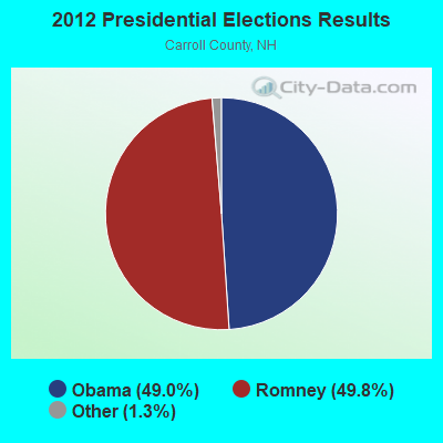
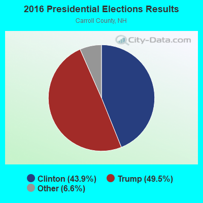
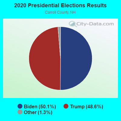
Graphs represent county-level data. Detailed 2008 Election Results
Religion statistics for Tamworth, NH (based on Carroll County data)
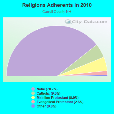
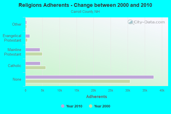
| Religion | Adherents | Congregations |
|---|---|---|
| Catholic | 4,304 | 2 |
| Mainline Protestant | 4,266 | 30 |
| Evangelical Protestant | 1,241 | 14 |
| Other | 366 | 5 |
| None | 37,641 | - |
Food Environment Statistics:
| This county: | 4.23 / 10,000 pop. |
| State: | 2.14 / 10,000 pop. |
| Carroll County: | 2.54 / 10,000 pop. |
| State: | 1.78 / 10,000 pop. |
| This county: | 8.47 / 10,000 pop. |
| New Hampshire: | 4.02 / 10,000 pop. |
| Carroll County: | 24.13 / 10,000 pop. |
| State: | 9.70 / 10,000 pop. |
| This county: | 8.8% |
| New Hampshire: | 7.6% |
| This county: | 21.2% |
| State: | 24.4% |
| Here: | 16.9% |
| New Hampshire: | 15.9% |
Businesses in Tamworth, NH
- Dunkin Donuts: 1
- U-Haul: 1
Strongest AM radio stations in Tamworth:
- WASR (1420 AM; 5 kW; WOLFEBORO, NH; Owner: RADIO WOLFEBORO, INC.)
- WBNC (1050 AM; 1 kW; CONWAY, NH; Owner: MT. WASHINGTON RADIO & GRAMOPHONE, L.L.C.)
- WRKO (680 AM; 50 kW; BOSTON, MA; Owner: ENTERCOM BOSTON LICENSE, LLC)
- WMTW (870 AM; 10 kW; GORHAM, ME; Owner: RADIO PARTNERS OF MAINE, L.P.)
- WPNH (1300 AM; 5 kW; PLYMOUTH, NH; Owner: NORTHEAST COMMUNICATIONS CORPORATION)
- WGIN (930 AM; 10 kW; ROCHESTER, NH; Owner: CAPSTAR TX LIMITED PARTNERSHIP)
- WEZS (1350 AM; 5 kW; LACONIA, NH; Owner: GARY W. HAMMOND)
- WEEI (850 AM; 50 kW; BOSTON, MA; Owner: ENTERCOM BOSTON LICENSE, LLC)
- WCRN (830 AM; 50 kW; WORCESTER, MA; Owner: CARTER BROADCASTING CORPORATION)
- WBZ (1030 AM; 50 kW; BOSTON, MA; Owner: INFINITY BROADCASTING OPERATIONS, INC.)
- WNNZ (640 AM; 50 kW; WESTFIELD, MA; Owner: CLEAR CHANNEL BROADCASTING LICENSES, INC.)
- WTME (780 AM; 10 kW; RUMFORD, ME; Owner: MOUNTAIN VALLEY BROADCASTING, INC.)
- WGAN (560 AM; 5 kW; PORTLAND, ME; Owner: SAGA COMMUNICATIONS OF NEW ENGLAND, LLC)
Strongest FM radio stations in Tamworth:
- WSCY (106.9 FM; MOULTONBOROUGH, NH; Owner: NORTHEAST COMMUNICATIONS CORPORATION)
- WVFM (105.7 FM; CAMPTON, NH; Owner: DEVON BROADCASTING COMPANY, INC.)
- WPKQ (103.7 FM; NORTH CONWAY, NH; Owner: CITADEL BROADCASTING COMPANY)
- WHOM (94.9 FM; MT. WASHINGTON, NH; Owner: CITADEL BROADCASTING COMPANY)
- WMWV (93.5 FM; CONWAY, NH; Owner: MT. WASHINGTON RADIO & GRAMOPHONE, L.L.C.)
- WMEA (90.1 FM; PORTLAND, ME; Owner: MAINE PUBLIC BROADCASTING CORPORATION)
- WVMJ (104.5 FM; CONWAY, NH; Owner: MT. WASHINGTON RADIO & GRAMOPHONE, L.L.C.)
- WLKZ (104.9 FM; WOLFEBORO, NH; Owner: TELE-MEDIA COMPANY OF NEW HAMPSHIRE, L.L.C.)
- WPNH-FM (100.1 FM; PLYMOUTH, NH; Owner: NORTHEAST COMMUNICATIONS CORPORATION)
- WBLM (102.9 FM; PORTLAND, ME; Owner: CITADEL BROADCASTING COMPANY)
- WHDQ (106.1 FM; CLAREMONT, NH; Owner: GREAT NORTHERN RADIO, L.L.C.)
- WGMT (97.7 FM; LYNDON, VT; Owner: VERMONT BROADCAST ASSOCIATES, INC.)
- WNHI (93.3 FM; BELMONT, NH; Owner: CONCORD BROADCASTING, L.L.C.)
- WMTK (106.3 FM; LITTLETON, NH; Owner: VERMONT BROADCAST ASSOCIATES, INC.)
- WMEX (106.5 FM; FARMINGTON, NH; Owner: WIMMEX, LLC)
- WEVH (91.3 FM; HANOVER, NH; Owner: NEW HAMPSHIRE PUBLIC RADIO INC)
- WXXS (102.3 FM; LANCASTER, NH; Owner: BARRY P. LUNDERVILLE)
- WLNH-FM (98.3 FM; LACONIA, NH; Owner: WLNH RADIO, INC)
- WBHG (101.5 FM; MEREDITH, NH; Owner: WLNH RADIO, INC)
TV broadcast stations around Tamworth:
- WMTW-TV (Channel 8; POLAND SPRING, ME; Owner: WMTW BROADCAST GROUP, LLC)
- WCSH (Channel 6; PORTLAND, ME; Owner: PACIFIC AND SOUTHERN COMPANY, INC.)
- WMEA-TV (Channel 26; BIDDEFORD, ME; Owner: MAINE PUBLIC BROADCASTING CORP.)
- WGME-TV (Channel 13; PORTLAND, ME; Owner: WGME LICENSEE, LLC)
- National Bridge Inventory (NBI) Statistics
- 23Number of bridges
- 131ft / 39.8mTotal length
- $72,266,000Total costs
- 36,944Total average daily traffic
- 2,330Total average daily truck traffic
- 54,664Total future (year 2042) average daily traffic
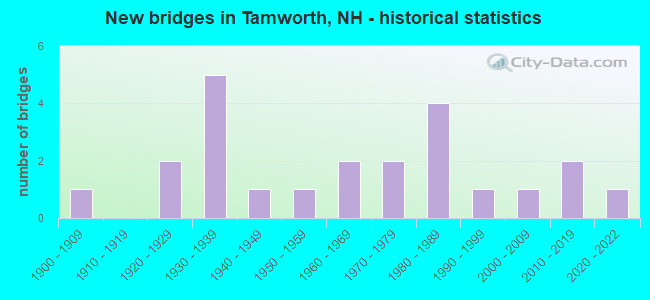
- New bridges - historical statistics
- 11900-1909
- 21920-1929
- 51930-1939
- 11940-1949
- 11950-1959
- 21960-1969
- 21970-1979
- 41980-1989
- 11990-1999
- 12000-2009
- 22010-2019
- 12020-2022
FCC Registered Antenna Towers:
16 (See the full list of FCC Registered Antenna Towers in Tamworth)FCC Registered Broadcast Land Mobile Towers:
4- State Police Troop E Rt 16 (Lat: 43.831472 Lon: -71.208972), Call Sign: KNIE439,
Assigned Frequencies: 44.8200 MHz, 44.9400 MHz, 45.4600 MHz, 155.475 MHz, 155.910 MHz, 156.090 MHz, Grant Date: 01/09/2024, Expiration Date: 01/10/2034, Registrant: State Of, Division Of Emergency Services New Hampshire, 33 Hazen Drive, Concord, NH 03305, Phone: (603) 271-6911, Email:
- Tamworth Police Dept Main St (Lat: 43.863139 Lon: -71.264528), Call Sign: WNDV374,
Assigned Frequencies: 155.475 MHz, 155.910 MHz, Grant Date: 07/15/2015, Expiration Date: 09/24/2025, Registrant: Nh Dept. Of Safety/Emergency Services And Communications, 33 Hazen Dr (Mailing), Concord, NH 03305, Phone: (603) 528-7541, Fax: (603) 271-6629, Email:
- TROOP E-TAMWORTH, Nhsp Troop E Barracks (Lat: 43.831472 Lon: -71.209444), Type: Tower, Structure height: 39.4 m, Call Sign: WQAC497,
Assigned Frequencies: 154.845 MHz, Grant Date: 03/30/2024, Expiration Date: 05/04/2034, Certifier: James R Kowalik, Registrant: State Of, Division Of Emergency Services New Hampshire, 33 Hazen Drive, Concord, NH 03305, Phone: (603) 271-6911, Email:
- Lat: 43.819917 Lon: -71.211250, Call Sign: WQOD605,
Assigned Frequencies: 150.845 MHz, 152.442 MHz, 157.477 MHz, 158.340 MHz, Grant Date: 10/18/2021, Expiration Date: 08/22/2031, Certifier: Larry Carrier, Registrant: New Wave Licensing Services, Inc., 818 Taneytown Rd, Gettysburg, PA 17325, Phone: (717) 334-0910, Email:
FCC Registered Microwave Towers:
5- Tamworth, Pine Hill Rd. (Lat: 43.838972 Lon: -71.332556), Type: Ltower, Structure height: 57.9 m, Call Sign: WPWF592,
Assigned Frequencies: 11585.0 MHz, 11565.0 MHz, 11648.1 MHz, Grant Date: 12/27/2012, Expiration Date: 11/05/2022, Cancellation Date: 08/14/2015, Certifier: Richard A Craig, Registrant: Verizon Wireless, 1120 Sanctuary Pkwy, #150 Gasa5reg, Alpharetta, GA 30009-7630, Phone: (770) 797-1070, Fax: (770) 797-1036, Email:
- Tamworth, 680 White Mountain Highway (Lat: 43.861111 Lon: -71.210722), Type: Ltower, Structure height: 58.2 m, Call Sign: WQOB782,
Assigned Frequencies: 11225.0 MHz, 11265.0 MHz, 11305.0 MHz, 11345.0 MHz, 11215.0 MHz, Grant Date: 06/29/2021, Expiration Date: 08/04/2031, Certifier: John E Monday, Registrant: At&t Services, Inc., 208 S Akard St, 20f, Dallas, TX 75202, Phone: (855) 699-7073, Email:
- TROOP E, White Mountain Highway (Lat: 43.831444 Lon: -71.208944), Type: Tower, Structure height: 50.3 m, Call Sign: WQOH921,
Assigned Frequencies: 6660.62 MHz, 5974.85 MHz, Grant Date: 07/12/2021, Expiration Date: 10/03/2031, Certifier: James Kowalik, Registrant: Nh Dept. Of Safety/Emergency Services And Communications, 33 Hazen Dr (Mailing), Concord, NH 03305, Phone: (603) 528-7541, Fax: (603) 271-6629, Email:
- AT10305, White Mountain Highway (Lat: 43.861111 Lon: -71.210722), Type: Ltower, Structure height: 53.1 m, Call Sign: WRMT670,
Assigned Frequencies: 11565.0 MHz, 11565.0 MHz, 11565.0 MHz, 11565.0 MHz, 11565.0 MHz, 11565.0 MHz, 11565.0 MHz, 11565.0 MHz, Grant Date: 06/02/2021, Expiration Date: 06/02/2031, Certifier: Michael Mateja, Registrant: Intelpath, Hinsdale, IL 60522, Phone: (312) 841-9188, Email:
- STATION, State Police Troop E Route 16 (Lat: 43.831444 Lon: -71.208944), Overall height: 50.6 m, Call Sign: WHI641,
Assigned Frequencies: 2192.80 MHz, Grant Date: 10/20/1998, Expiration Date: 12/30/2008, Cancellation Date: 12/05/2007, Registrant: Nh Dept Of Safety/State Police Div, 33 Hazen Drive, Concord, NH 03305, Phone: (603) 271-2421, Fax: (603) 271-6629, Email:
FCC Registered Amateur Radio Licenses:
10 (See the full list of FCC Registered Amateur Radio Licenses in Tamworth)2003 - 2018 National Fire Incident Reporting System (NFIRS) incidents
- Fire incident types reported to NFIRS in Tamworth, NH
- 16356.2%Structure Fires
- 7224.8%Outside Fires
- 4114.1%Mobile Property/Vehicle Fires
- 144.8%Other
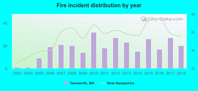 According to the data from the years 2003 - 2018 the average number of fire incidents per year is 18. The highest number of reported fires - 32 took place in 2010, and the least - 1 in 2003. The data has a rising trend.
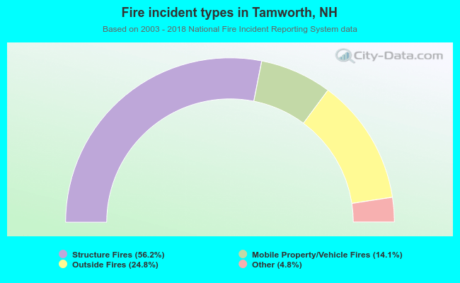 When looking into fire subcategories, the most reports belonged to: Structure Fires (56.2%), and Outside Fires (24.8%).
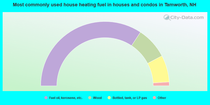
- 68.6%Fuel oil, kerosene, etc.
- 16.0%Wood
- 13.5%Bottled, tank, or LP gas
- 1.7%Electricity
- 0.2%Coal or coke
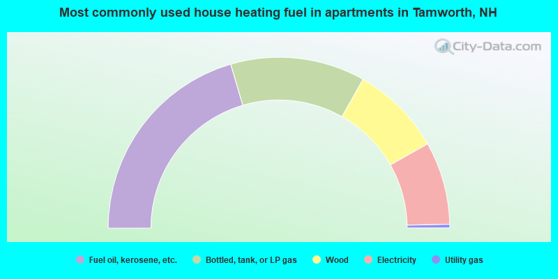
- 40.9%Fuel oil, kerosene, etc.
- 25.5%Bottled, tank, or LP gas
- 17.2%Wood
- 15.7%Electricity
- 0.7%Utility gas
Tamworth compared to New Hampshire state average:
- Unemployed percentage below state average.
- Black race population percentage significantly below state average.
- Hispanic race population percentage significantly below state average.
- Foreign-born population percentage significantly below state average.
- Length of stay since moving in significantly above state average.
- Number of rooms per house significantly below state average.
- House age significantly below state average.
- Number of college students below state average.

|
Total of 3 patent applications in 2008-2024.