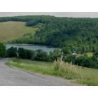
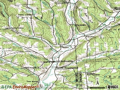
Taylor, New York
Submit your own pictures of this town and show them to the world
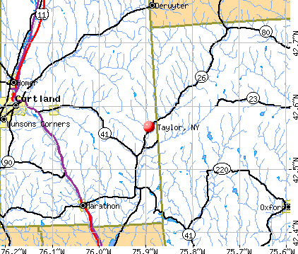
- OSM Map
- General Map
- Google Map
- MSN Map
Population change since 2000: +4.6%
 |
| Males: 261 | |
| Females: 262 |
| Median resident age: | 40.7 years |
| New York median age: | 40.7 years |
Zip codes: 13040.
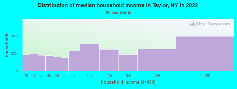
| Taylor: | $68,501 |
| NY: | $79,557 |
Estimated per capita income in 2022: $31,865 (it was $16,677 in 2000)
Taylor town income, earnings, and wages data
Estimated median house or condo value in 2022: $125,103 (it was $59,600 in 2000)
| Taylor: | $125,103 |
| NY: | $400,400 |
Mean prices in 2022: all housing units: $188,917; detached houses: $187,917; townhouses or other attached units: $146,406; in 2-unit structures: $635,934; in 3-to-4-unit structures: $122,178; in 5-or-more-unit structures: $371,569; mobile homes: $103,239
Detailed information about poverty and poor residents in Taylor, NY
Compare current foreclosures near Taylor, NY:
| Photo | Address | Area | Beds / Baths | Price | Details |
|---|---|---|---|---|---|

|
#1
Brown Ave
Cortland, NY 13045
|
1,972 sq. feet
|
1 baths 4 beds |
$86,000
|
show details |

|
#2
Pine Hill Rd
Marathon, NY 13803
|
- sq. feet
|
2 baths 3 beds |
$221,660
|
show details |

|
#3
County Road 10
Norwich, NY 13815
|
1,572 sq. feet
|
1 baths 5 beds |
$15,900
|
show details |

|
#4
Ny Route 26
Whitney Point, NY 13862
|
2,612 sq. feet
|
2 baths 4 beds |
$49,900
|
show details |

|
#5
Old State Highway 23 # 23
South Plymouth, NY 13844
|
1,196 sq. feet
|
2 baths 3 beds |
$25,900
|
show details |

|
#6
W Cottage Ln
De Ruyter, NY 13052
|
- sq. feet
|
3 baths 3 beds |
show details | |

|
#7
Hubbard St
Cortland, NY 13045
|
2,126 sq. feet
|
2 baths 3 beds |
show details | |

|
#8
Briarmeadow Rd
Cortland, NY 13045
|
1,760 sq. feet
|
2 baths 3 beds |
show details | |

|
#9
Hubbard St
Cortland, NY 13045
|
1,704 sq. feet
|
2 baths 3 beds |
show details | |

|
#10
Randall St
Cortland, NY 13045
|
1,484 sq. feet
|
2 baths 3 beds |
show details |
| Photo | Address | Area | Beds / Baths | Price | Details |
|---|---|---|---|---|---|

|
#11
Briarmeadow Rd
Cortland, NY 13045
|
1,760 sq. feet
|
2 baths 3 beds |
show details | |

|
#12
State Route 26
Willet, NY 13863
|
1,064 sq. feet
|
1 baths 2 beds |
show details | |

|
#13
Kent Dr
Cortland, NY 13045
|
1,470 sq. feet
|
1 baths 3 beds |
show details | |

|
#14
Franklin St
Cortland, NY 13045
|
764 sq. feet
|
1 baths 2 beds |
show details | |

|
#15
Port Watson St
Cortland, NY 13045
|
2,180 sq. feet
|
2 baths 4 beds |
show details | |

|
#16
River St
Cortland, NY 13045
|
1,318 sq. feet
|
1 baths 3 beds |
show details | |

|
#17
Redwood Ave
Cortland, NY 13045
|
672 sq. feet
|
1 baths 2 beds |
show details | |

|
#18
Pendleton St
Cortland, NY 13045
|
2,057 sq. feet
|
1 baths 3 beds |
show details | |

|
#19
Stewart Pl
Cortland, NY 13045
|
2,710 sq. feet
|
2 baths 8 beds |
show details | |

|
#20
Grant St
Cortland, NY 13045
|
2,228 sq. feet
|
2 baths 4 beds |
show details |
| Photo | Address | Area | Beds / Baths | Price | Details |
|---|---|---|---|---|---|

|
#21
E Main St
Cortland, NY 13045
|
2,553 sq. feet
|
3 baths 4 beds |
show details | |

|
#22
Preble Rd
Preble, NY 13141
|
1,096 sq. feet
|
1 baths 3 beds |
show details | |

|
#23
Tobin Dr
Homer, NY 13077
|
1,388 sq. feet
|
1 baths 3 beds |
show details | |

|
#24
Miller St
Cortland, NY 13045
|
2,444 sq. feet
|
2 baths 5 beds |
show details | |

|
#25
Cherry St
Homer, NY 13077
|
548 sq. feet
|
1 baths 2 beds |
show details | |

|
#26
State Route 13
Cortland, NY 13045
|
1,641 sq. feet
|
1 baths 4 beds |
show details | |

|
#27
Squires St
Cortland, NY 13045
|
1,424 sq. feet
|
2 baths 2 beds |
show details | |

|
#28
Traverse Rd
Cortland, NY 13045
|
1,560 sq. feet
|
2 baths 4 beds |
show details | |

|
#29
Raymond Ave
Cortland, NY 13045
|
984 sq. feet
|
2 baths 4 beds |
show details | |

|
#30
Tompkins St
Cortland, NY 13045
|
2,358 sq. feet
|
2 baths 5 beds |
show details |
| Photo | Address | Area | Beds / Baths | Price | Details |
|---|---|---|---|---|---|

|
#31
Bellrose Ave
Cortland, NY 13045
|
1,050 sq. feet
|
1 baths 3 beds |
show details | |

|
#32
Creal Rd
Homer, NY 13077
|
1,296 sq. feet
|
1 baths 3 beds |
show details | |

|
#33
E Homer Baltimore Rd
Homer, NY 13077
|
1,660 sq. feet
|
2 baths 3 beds |
show details | |

|
#34
Divers Xing
Marathon, NY 13803
|
2,288 sq. feet
|
2 baths 4 beds |
show details | |

|
#35
Route 91
Tully, NY 13159
|
1,344 sq. feet
|
2 baths 3 beds |
show details | |

|
#36
Sherman Rd
Cortland, NY 13045
|
1,456 sq. feet
|
2 baths 3 beds |
show details | |

|
#37
State Route 23
Cincinnatus, NY 13040
|
2,136 sq. feet
|
2 baths 4 beds |
show details | |

|
#38
Maybury Rd
Mc Graw, NY 13101
|
2,880 sq. feet
|
1 baths 3 beds |
show details | |

|
#39
Soshinsky Rd
Mc Graw, NY 13101
|
2,000 sq. feet
|
2 baths 3 beds |
show details | |

|
#40
State Route 90
Cortland, NY 13045
|
2,802 sq. feet
|
2 baths 5 beds |
show details |
| Photo | Address | Area | Beds / Baths | Price | Details |
|---|---|---|---|---|---|

|
#41
Mcgraw Marathon Rd
Mc Graw, NY 13101
|
1,180 sq. feet
|
1 baths 3 beds |
show details | |

|
#42
Mcgraw Marathon Rd
Mc Graw, NY 13101
|
1,180 sq. feet
|
1 baths 3 beds |
show details | |

|
#43
Center St
Mc Graw, NY 13101
|
1,305 sq. feet
|
1 baths 3 beds |
show details | |

|
#44
W Center St
Mc Graw, NY 13101
|
1,474 sq. feet
|
1 baths 3 beds |
show details | |

|
#45
Mclean Rd
Cortland, NY 13045
|
1,259 sq. feet
|
1 baths 3 beds |
show details | |

|
#46
Friendly Shores Dr
Tully, NY 13159
|
864 sq. feet
|
1 baths 3 beds |
show details | |

|
#47
Luker Rd
Cortland, NY 13045
|
1,420 sq. feet
|
2 baths 3 beds |
show details | |

|
#48
S Cortland Virgil Rd
Cortland, NY 13045
|
1,689 sq. feet
|
1 baths 3 beds |
show details | |

|
#49
State Route 41
Willet, NY 13863
|
2,040 sq. feet
|
1 baths 4 beds |
show details | |

|
Check over 1 million property listings on Foreclosure.com!
|
browse all offers | |||

- 49494.5%White alone
- 183.4%Hispanic
- 71.3%Two or more races
- 20.4%Black alone
- 20.4%Asian alone
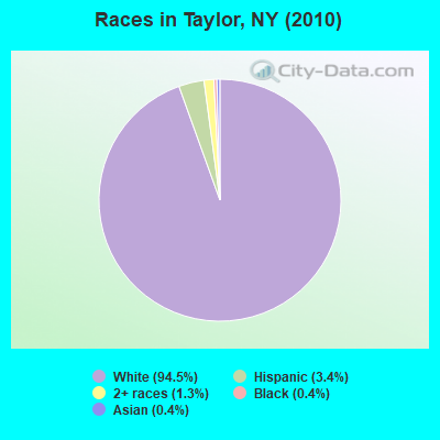
Races in Taylor detailed stats: ancestries, foreign born residents, place of birth
 Recent articles from our blog. Our writers, many of them Ph.D. graduates or candidates, create easy-to-read articles on a wide variety of topics.


 | Stalker tries to break into Taylor Swift's NYC apartment (11 replies) |
| Upper Middle class african-american communities in ny (2052 replies) |
| NY Pro Sports: Why so bad lately? (375 replies) |
| Fishy George Santos (465 replies) |
| Deranged man busted trying to break into Taylor Swift’s Tribeca apartment (6 replies) |
| I just can't get past Lord & Taylor disappearing (12 replies) |
Latest news from Taylor, NY collected exclusively by city-data.com from local newspapers, TV, and radio stations
Ancestries: English (16.8%), German (14.2%), United States (12.6%), Irish (7.8%), Norwegian (3.2%), Dutch (3.0%).
Current Local Time: EST time zone
Land area: 30.0 square miles.
Population density: 17 people per square mile (very low).
9 residents are foreign born
| This town: | 1.8% |
| New York: | 20.4% |
| Taylor town: | 1.9% ($1,150) |
| New York: | 1.9% ($2,847) |
Nearest city with pop. 50,000+: Syracuse, NY  (32.5 miles , pop. 147,306).
Nearest city with pop. 200,000+: Rochester, NY (94.1 miles , pop. 219,773).
Nearest city with pop. 1,000,000+: Bronx, NY (161.1 miles , pop. 1,332,650).
Nearest cities:
), ), ), ), ), ), )Latitude: 42.61 N, Longitude: 75.92 W
Area code commonly used in this area: 607

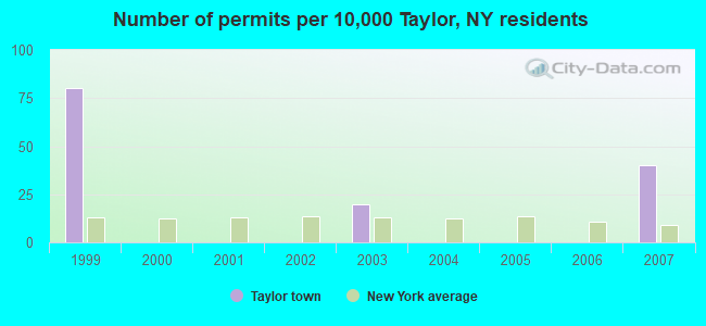
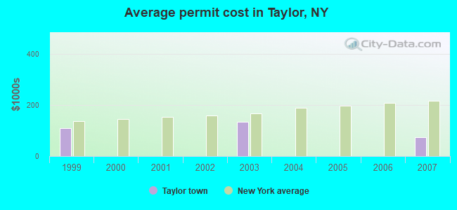
Single-family new house construction building permits:
- 2007: 2 buildings, average cost: $75,000
- 2003: 1 building, cost: $132,800
- 1999: 4 buildings, average cost: $109,200
| Here: | 5.0% |
| New York: | 4.4% |
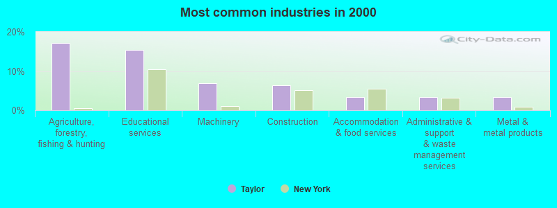
- Agriculture, forestry, fishing & hunting (17.1%)
- Educational services (15.4%)
- Machinery (6.8%)
- Construction (6.4%)
- Accommodation & food services (3.4%)
- Administrative & support & waste management services (3.4%)
- Metal & metal products (3.4%)
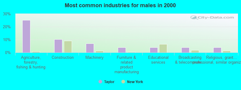
- Agriculture, forestry, fishing & hunting (25.2%)
- Construction (10.2%)
- Machinery (7.1%)
- Furniture & related product manufacturing (3.9%)
- Educational services (3.9%)
- Broadcasting & telecommunications (3.9%)
- Religious, grantmaking, civic, professional, similar organizations (3.9%)
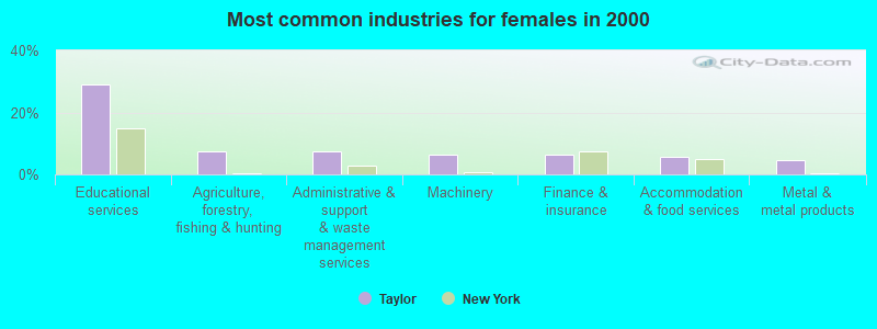
- Educational services (29.0%)
- Agriculture, forestry, fishing & hunting (7.5%)
- Administrative & support & waste management services (7.5%)
- Machinery (6.5%)
- Finance & insurance (6.5%)
- Accommodation & food services (5.6%)
- Metal & metal products (4.7%)
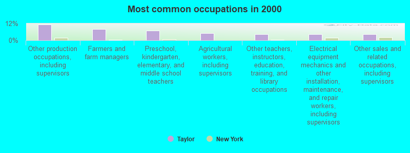
- Other production occupations, including supervisors (11.1%)
- Farmers and farm managers (8.1%)
- Preschool, kindergarten, elementary, and middle school teachers (6.8%)
- Agricultural workers, including supervisors (5.1%)
- Other teachers, instructors, education, training, and library occupations (4.3%)
- Electrical equipment mechanics and other installation, maintenance, and repair workers, including supervisors (4.3%)
- Other sales and related occupations, including supervisors (4.3%)
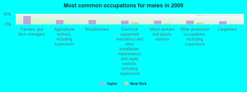
- Farmers and farm managers (13.4%)
- Agricultural workers, including supervisors (7.1%)
- Woodworkers (7.1%)
- Electrical equipment mechanics and other installation, maintenance, and repair workers, including supervisors (6.3%)
- Metal workers and plastic workers (6.3%)
- Other production occupations, including supervisors (6.3%)
- Carpenters (5.5%)
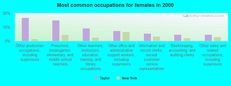
- Other production occupations, including supervisors (16.8%)
- Preschool, kindergarten, elementary, and middle school teachers (15.0%)
- Other teachers, instructors, education, training, and library occupations (9.3%)
- Other office and administrative support workers, including supervisors (7.5%)
- Information and record clerks, except customer service representatives (5.6%)
- Bookkeeping, accounting, and auditing clerks (4.7%)
- Other sales and related occupations, including supervisors (4.7%)
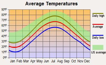
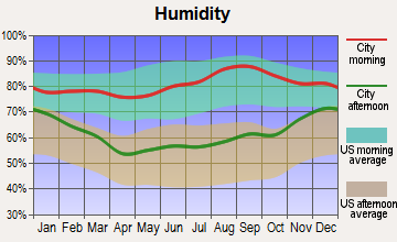
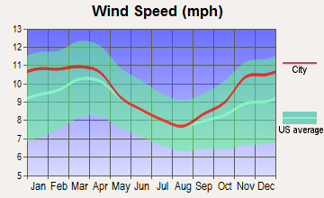
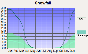
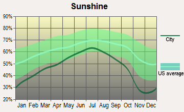
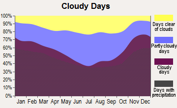
Average climate in Taylor, New York
Based on data reported by over 4,000 weather stations
(lower is better)
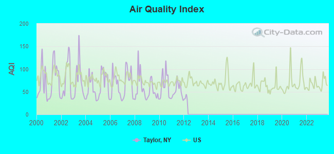
Air Quality Index (AQI) level in 2011 was 52.6. This is better than average.
| City: | 52.6 |
| U.S.: | 72.6 |
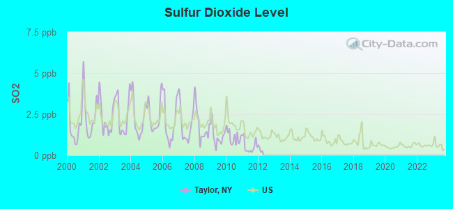
Sulfur Dioxide (SO2) [ppb] level in 2011 was 0.547. This is significantly better than average. Closest monitor was 11.0 miles away from the city center.
| City: | 0.547 |
| U.S.: | 1.515 |
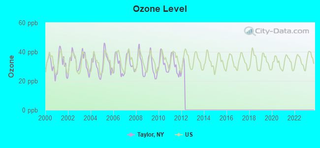
Ozone [ppb] level in 2011 was 30.6. This is about average. Closest monitor was 11.0 miles away from the city center.
| City: | 30.6 |
| U.S.: | 33.3 |
Tornado activity:
Taylor-area historical tornado activity is slightly below New York state average. It is 69% smaller than the overall U.S. average.
On 5/31/1998, a category F3 (max. wind speeds 158-206 mph) tornado 38.9 miles away from the Taylor town center injured 12 people and caused $3 million in damages.
On 10/14/1989, a category F2 (max. wind speeds 113-157 mph) tornado 10.6 miles away from the town center killed 2 people and injured 3 people and caused between $5000 and $50,000 in damages.
Earthquake activity:
Taylor-area historical earthquake activity is significantly above New York state average. It is 67% smaller than the overall U.S. average.On 10/7/1983 at 10:18:46, a magnitude 5.3 (5.1 MB, 5.3 LG, 5.1 ML, Class: Moderate, Intensity: VI - VII) earthquake occurred 122.4 miles away from Taylor center
On 4/20/2002 at 10:50:47, a magnitude 5.3 (5.3 ML, Depth: 3.0 mi) earthquake occurred 172.5 miles away from Taylor center
On 4/20/2002 at 10:50:47, a magnitude 5.2 (5.2 MB, 4.2 MS, 5.2 MW, 5.0 MW) earthquake occurred 170.5 miles away from the city center
On 8/23/2011 at 17:51:04, a magnitude 5.8 (5.8 MW, Depth: 3.7 mi) earthquake occurred 341.8 miles away from Taylor center
On 9/25/1998 at 19:52:52, a magnitude 5.2 (4.8 MB, 4.3 MS, 5.2 LG, 4.5 MW, Depth: 3.1 mi) earthquake occurred 242.5 miles away from the city center
On 1/16/1994 at 01:49:16, a magnitude 4.6 (4.6 MB, 4.6 LG, Depth: 3.1 mi, Class: Light, Intensity: IV - V) earthquake occurred 157.6 miles away from the city center
Magnitude types: regional Lg-wave magnitude (LG), body-wave magnitude (MB), local magnitude (ML), surface-wave magnitude (MS), moment magnitude (MW)
Natural disasters:
The number of natural disasters in Cortland County (14) is near the US average (15).Major Disasters (Presidential) Declared: 7
Emergencies Declared: 5
Causes of natural disasters: Floods: 7, Storms: 7, Hurricanes: 2, Blizzard: 1, Heavy Rain: 1, Landslide: 1, Power Outage: 1, Snowstorm: 1, Wind: 1, Winter Storm: 1, Other: 2 (Note: some incidents may be assigned to more than one category).
Hospitals and medical centers near Taylor:
- CROWN CENTER FOR NURSING AND REHABILITATION (Nursing Home, about 13 miles away; CORTLAND, NY)
- CARING COMMUNITY HOSPICE OF CORTLAND (Hospital, about 13 miles away; CORTLAND, NY)
- CORTLAND PARK REHABILITATION AND NURSING CENTER (Nursing Home, about 13 miles away; CORTLAND, NY)
- CORTLAND COUNTY HEALTH DEPARTMENT (Home Health Center, about 14 miles away; CORTLAND, NY)
- CORTLAND REGIONAL MEDICAL CENTER, INC Acute Care Hospitals (about 14 miles away; CORTLAND, NY)
- ST. JOSEPH'S - CORTLAND (Dialysis Facility, about 15 miles away; CORTLAND, NY)
Colleges/universities with over 2000 students nearest to Taylor:
- SUNY College at Cortland (about 15 miles; Cortland, NY; Full-time enrollment: 6,838)
- Tompkins Cortland Community College (about 21 miles; Dryden, NY; FT enrollment: 3,884)
- Colgate University (about 25 miles; Hamilton, NY; FT enrollment: 3,094)
- Morrisville State College (about 26 miles; Morrisville, NY; FT enrollment: 2,823)
- Cornell University (about 31 miles; Ithaca, NY; FT enrollment: 20,360)
- Onondaga Community College (about 32 miles; Syracuse, NY; FT enrollment: 8,920)
- SUNY College of Environmental Science and Forestry (about 32 miles; Syracuse, NY; FT enrollment: 2,044)
Points of interest:
Church in Taylor: Taylor Wesleyan Church (A). Display/hide its location on the map
Cemeteries: Taylor Rural Cemetery (1), Holland Cemetery (2), Union Valley Cemetery (3), Potter Hill Cemetery (4), Hawley Cemetery (5). Display/hide their locations on the map
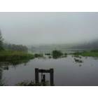
Lake: Solon Pond (A). Display/hide its location on the map
Creek: Wells Creek (A). Display/hide its location on the map
| This town: | 2.7 people |
| New York: | 2.6 people |
| This town: | 77.5% |
| Whole state: | 63.5% |
| This town: | 10.5% |
| Whole state: | 6.8% |
Likely homosexual households (counted as self-reported same-sex unmarried-partner households)
- Lesbian couples: 1.6% of all households
- Gay men: 0.5% of all households
| This town: | 11.4% |
| Whole state: | 14.6% |
| This town: | 5.2% |
| Whole state: | 7.4% |
For population 15 years and over in Taylor:
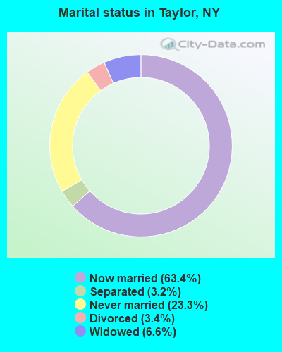
- Never married: 23.3%
- Now married: 63.4%
- Separated: 3.2%
- Widowed: 6.6%
- Divorced: 3.4%
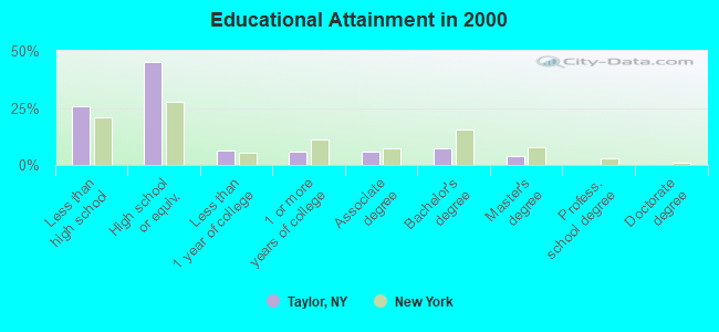
For population 25 years and over in Taylor:
- High school or higher: 74.4%
- Bachelor's degree or higher: 11.3%
- Graduate or professional degree: 3.9%
- Unemployed: 7.5%
- Mean travel time to work (commute): 31.6 minutes
| Here: | 9.7 |
| New York average: | 14.2 |
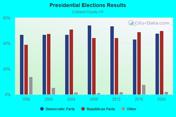
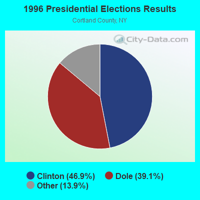
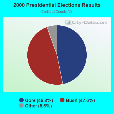
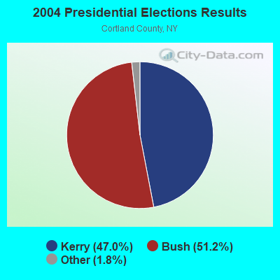
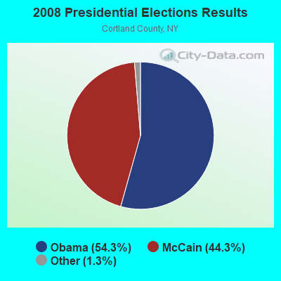

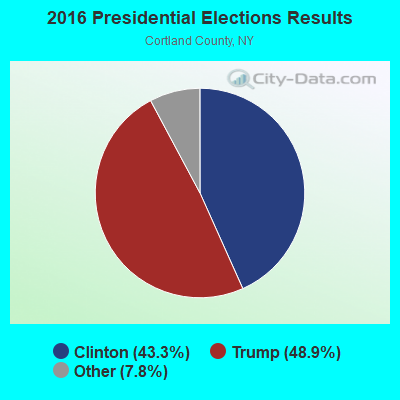

Graphs represent county-level data. Detailed 2008 Election Results
Religion statistics for Taylor, NY (based on Cortland County data)
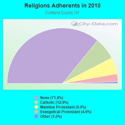
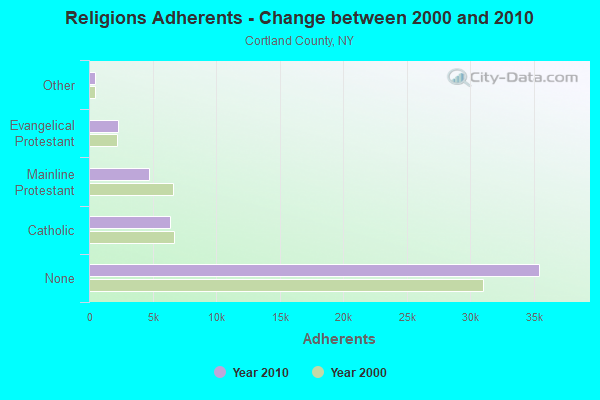
| Religion | Adherents | Congregations |
|---|---|---|
| Catholic | 6,378 | 5 |
| Mainline Protestant | 4,756 | 25 |
| Evangelical Protestant | 2,291 | 29 |
| Other | 483 | 6 |
| None | 35,428 | - |
Food Environment Statistics:
| Here: | 2.48 / 10,000 pop. |
| New York: | 4.13 / 10,000 pop. |
| Cortland County: | 0.41 / 10,000 pop. |
| State: | 0.92 / 10,000 pop. |
| Here: | 3.92 / 10,000 pop. |
| New York: | 1.68 / 10,000 pop. |
| Here: | 9.29 / 10,000 pop. |
| New York: | 8.82 / 10,000 pop. |
| Cortland County: | 7.4% |
| New York: | 8.2% |
| Cortland County: | 24.5% |
| New York: | 23.8% |
| Cortland County: | 11.7% |
| State: | 15.6% |
Strongest AM radio stations in Taylor:
- WSYR (570 AM; 5 kW; SYRACUSE, NY; Owner: CLEAR CHANNEL BROADCASTING LICENSES, INC.)
- WHCU (870 AM; 5 kW; ITHACA, NY; Owner: EAGLE BROADCASTING COMPANY, INC.)
- WKRT (920 AM; 1 kW; CORTLAND, NY; Owner: CITADEL BROADCASTING COMPANY)
- WGY (810 AM; 50 kW; SCHENECTADY, NY; Owner: CLEAR CHANNEL BROADCASTING LICENSES, INC.)
- WINR (680 AM; 5 kW; BINGHAMTON, NY; Owner: CLEVELAND RADIO LICENSES, LLC)
- WHEN (620 AM; 5 kW; SYRACUSE, NY; Owner: CLEAR CHANNEL BROADCASTING LICENSES, INC.)
- WNBF (1290 AM; 9 kW; BINGHAMTON, NY; Owner: CITADEL BROADCASTING COMPANY)
- WHAM (1180 AM; 50 kW; ROCHESTER, NY; Owner: CITICASTERS LICENSES, L.P.)
- WNSS (1260 AM; 5 kW; SYRACUSE, NY; Owner: CITADEL BROADCASTING COMPANY)
- WTKO (1470 AM; 5 kW; ITHACA, NY; Owner: EAGLE II BROADCASTING CORPORATION)
- WMCA (570 AM; 50 kW; NEW YORK, NY; Owner: SALEM MEDIA OF NEW YORK, LLC)
- WPTR (1540 AM; 50 kW; ALBANY, NY; Owner: KIMTRON, INC.)
- WWJZ (640 AM; 50 kW; MOUNT HOLLY, NJ; Owner: ABC, INC.)
Strongest FM radio stations in Taylor:
- WIII (99.9 FM; CORTLAND, NY; Owner: CITADEL BROADCASTING COMPANY)
- WXHC (101.5 FM; HOMER, NY; Owner: EVES BROADCASTING, INC.)
- WBKT (95.3 FM; NORWICH, NY; Owner: BANJO COMMUNICATIONS GROUP, INC)
- WYXL (97.3 FM; ITHACA, NY; Owner: EAGLE BROADCASTING COMPANY)
- WWDG (105.1 FM; DERUYTER, NY; Owner: CLEAR CHANNEL BROADCASTING LICENSES, INC.)
- WCNY-FM (91.3 FM; SYRACUSE, NY; Owner: THE PUB. B/C COUNC. OF CEN. NY, INC.)
- WKXZ (93.9 FM; NORWICH, NY; Owner: BANJO COMMUNICATIONS GROUP, INC)
- WHWK (98.1 FM; BINGHAMTON, NY; Owner: CITADEL BROADCASTING COMPANY)
- WNTQ (93.1 FM; SYRACUSE, NY; Owner: CITADEL BROADCASTING COMPANY)
- WPHR (106.9 FM; AUBURN, NY; Owner: CLEAR CHANNEL BROADCASTING LICENSES, INC.)
- WMHR (102.9 FM; SYRACUSE, NY; Owner: MARS HILL BROADCASTING CO., INC.)
- WYYY (94.5 FM; SYRACUSE, NY; Owner: CLEAR CHANNEL BROADCASTING LICENSES, INC.)
- WAAL (99.1 FM; BINGHAMTON, NY; Owner: CITADEL BROADCASTING COMPANY)
- WSKG-FM (89.3 FM; BINGHAMTON, NY; Owner: WSKG PUB.TELECOMMUNICATIONS COUNCIL)
- W251AK (98.1 FM; NEDROW, NY; Owner: PATHWAY COMMUNITY RADIO, INC.)
- WSQX-FM (91.5 FM; BINGHAMTON, NY; Owner: WSKG PUBLIC TELECOMMUNICATIONS CNCL.)
- WMXW (103.3 FM; VESTAL, NY; Owner: CLEAR CHANNEL BROADCASTING LICENSES, INC.)
- WMCR-FM (106.3 FM; ONEIDA, NY; Owner: WARREN BROADCASTING CO. INC.)
- W278AH (103.5 FM; SYRACUSE, JAMESVILLE, NY; Owner: CALVARY CHAPEL OF THE FINGER LAKES, INC.)
- WWYL (104.1 FM; CHENANGO BRIDGE, NY; Owner: CITADEL BROADCASTING COMPANY)
TV broadcast stations around Taylor:
- WIXT-TV (Channel 9; SYRACUSE, NY; Owner: CENTRAL NY NEWS, INC.)
- WCNY-TV (Channel 24; SYRACUSE, NY; Owner: PUBLIC BROADCASTING COUNCIL OF CENTRAL NEW YORK)
- WSTM-TV (Channel 3; SYRACUSE, NY; Owner: WSTM LICENSE SUBSIDIARY, INC.)
- WSYT (Channel 68; SYRACUSE, NY; Owner: WSYT LICENSEE L.P.)
- WNYS-TV (Channel 43; SYRACUSE, NY; Owner: RKM MEDIA, INC.)
- WTVH (Channel 5; SYRACUSE, NY; Owner: WTVH LICENSE, INC.)
- WFXV (Channel 33; UTICA, NY; Owner: QUORUM OF UTICA LICENSE, LLC)
- WSKG-TV (Channel 46; BINGHAMTON, NY; Owner: WSKG PUBLIC TELECOMMUNICATIONS COUNCIL)
- WICZ-TV (Channel 40; BINGHAMTON, NY; Owner: STAINLESS BROADCASTING, L.P.)
- WBNG-TV (Channel 12; BINGHAMTON, NY; Owner: TELEVISION STATION GROUP LICENSE SUBSIDIARY, LLC)
- National Bridge Inventory (NBI) Statistics
- 5Number of bridges
- 26ft / 8.0mTotal length
- $4,443,000Total costs
- 2,248Total average daily traffic
- 283Total average daily truck traffic
FCC Registered Antenna Towers:
4- David L Tanner, 4563 Potter Hill Rd (Lat: 42.628361 Lon: -75.917861), Type: 60.7, Structure height: 36023 m, Overall height: 59.4 m, Registrant: Cortland County, Dtanner@cortland-Co.Org, , Cortl-and, Phone: (607) 753-3311
- David L Tanner, 4563 Potter Hill Rd (Lat: 42.628361 Lon: -75.917861), Type: 60.7, Structure height: 36023 m, Overall height: 59.4 m, Registrant: Cortland County, Dtanner@cortland-Co.Org, , Cortl-and, Phone: (607) 753-3311
- David L Tanner, 4563 Potter Hill Rd (Lat: 42.628361 Lon: -75.917861), Type: 60.7, Structure height: 36023 m, Overall height: 59.4 m, Registrant: Cortland County, Dtanner@cortland-Co.Org, , Cortl-and, Phone: (607) 753-3311
- Scott Roman, 4563 Potter Hill Rd (Lat: 42.628361 Lon: -75.917861), Type: 60.7, Structure height: 36023 m, Overall height: 59.4 m, Registrant: Cortland County, Sroman@cortland-Co.Org, , Cortl-and, Phone: (607) 753-5064
FCC Registered Microwave Towers:
1- EASTSIDENEW, 4563 Potter Hill Rd (Lat: 42.628472 Lon: -75.917917), Type: Ltower, Structure height: 59.4 m, Overall height: 60.7 m, Call Sign: WQRI960,
Assigned Frequencies: 11345.0 MHz, 6034.15 MHz, 5945.20 MHz, Grant Date: 02/24/2023, Expiration Date: 05/23/2033, Certifier: David Tanner, Registrant: Cortland County 911, 54 Greenbush Street; Suite 201, Cortland, NY 13045, Phone: (607) 753-5064, Fax: (607) 756-8457, Email:
FCC Registered Amateur Radio Licenses:
1- Call Sign: KD2GBM, Licensee ID: L01854417, Grant Date: 04/01/2014, Expiration Date: 04/01/2024, Certifier: Joshua Kisner, Registrant: Joshua Kisner, 3520 Doran Hill Rd, Taylor, NY 13040
- 58.5%Fuel oil, kerosene, etc.
- 27.7%Wood
- 7.7%Bottled, tank, or LP gas
- 3.1%Electricity
- 1.5%Coal or coke
- 1.5%Other fuel
- 60.6%Fuel oil, kerosene, etc.
- 21.2%Wood
- 18.2%Bottled, tank, or LP gas
Taylor compared to New York state average:
- Median house value significantly below state average.
- Unemployed percentage below state average.
- Black race population percentage significantly below state average.
- Hispanic race population percentage significantly below state average.
- Foreign-born population percentage significantly below state average.
- Renting percentage significantly below state average.
- Length of stay since moving in significantly above state average.
- Number of rooms per house significantly below state average.
- House age significantly below state average.
- Number of college students significantly below state average.
- Percentage of population with a bachelor's degree or higher significantly below state average.