Ten Mile, Tennessee
Submit your own pictures of this place and show them to the world
- OSM Map
- General Map
- Google Map
- MSN Map

| Males: 1,646 | |
| Females: 1,624 |
| Median resident age: | 37.0 years |
| Tennessee median age: | 35.9 years |
Zip code: 37880
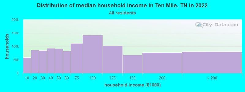
| Ten Mile: | $56,928 |
| TN: | $65,254 |
Estimated per capita income in 2022: $25,290 (it was $13,461 in 2000)
Ten Mile CCD income, earnings, and wages data
Estimated median house or condo value in 2022: $188,557 (it was $67,500 in 2000)
| Ten Mile: | $188,557 |
| TN: | $284,800 |
Mean prices in 2022: all housing units: $218,937; detached houses: $269,424; townhouses or other attached units: $615,551; mobile homes: $96,553; occupied boats, rvs, vans, etc.: $52,453
Detailed information about poverty and poor residents in Ten Mile, TN
Compare current foreclosures near Ten Mile, TN:
| Photo | Address | Area | Beds / Baths | Price | Details |
|---|---|---|---|---|---|

|
#1
Goins Hill Rd
Ten Mile, TN 37880
|
1,960 sq. feet
|
- baths - beds |
show details | |

|
#2
State Highway 304
Ten Mile, TN 37880
|
2,544 sq. feet
|
1 baths - beds |
show details | |

|
#3
Gordon Hollow Rd
Ten Mile, TN 37880
|
576 sq. feet
|
1 baths - beds |
show details | |

|
#4
Bayview Dr
Ten Mile, TN 37880
|
1,431 sq. feet
|
2 baths - beds |
show details | |

|
#5
County Road 290
Ten Mile, TN 37880
|
1,820 sq. feet
|
1 baths - beds |
show details | |

|
#6
Roberts Cemetery Ln
Ten Mile, TN 37880
|
- sq. feet
|
- baths - beds |
show details | |

|
#7
Dry Fork Valley Rd
Ten Mile, TN 37880
|
980 sq. feet
|
- baths - beds |
show details | |

|
#8
State Highway 304
Ten Mile, TN 37880
|
- sq. feet
|
- baths - beds |
show details | |

|
#9
River Rd
Ten Mile, TN 37880
|
- sq. feet
|
- baths - beds |
show details | |

|
#10
State Highway 304 # 304
Ten Mile, TN 37880
|
1,064 sq. feet
|
- baths - beds |
show details |
| Photo | Address | Area | Beds / Baths | Price | Details |
|---|---|---|---|---|---|

|
#11
J D Walden Rd
Ten Mile, TN 37880
|
- sq. feet
|
- baths - beds |
show details | |

|
#12
Reed Rd
Ten Mile, TN 37880
|
- sq. feet
|
- baths - beds |
show details | |

|
#13
W Morris St
Sweetwater, TN 37874
|
1,251 sq. feet
|
1 baths 3 beds |
show details | |

|
#14
Eaves Ferry Rd
Decatur, TN 37322
|
1,440 sq. feet
|
2 baths 3 beds |
show details | |

|
#15
Lavender St
Spring City, TN 37381
|
1,041 sq. feet
|
1 baths 3 beds |
show details | |

|
#16
Allison Dr
Harriman, TN 37748
|
1,768 sq. feet
|
2 baths 3 beds |
show details | |

|
#17
State Highway 11 North
Sweetwater, TN 37874
|
1,726 sq. feet
|
2 baths 3 beds |
show details | |

|
#18
W Morris St
Sweetwater, TN 37874
|
875 sq. feet
|
1 baths 2 beds |
show details | |

|
#19
County Road 112
Athens, TN 37303
|
1,456 sq. feet
|
2 baths 3 beds |
show details | |

|
#20
Browder St
Sweetwater, TN 37874
|
1,400 sq. feet
|
2 baths 3 beds |
show details |
| Photo | Address | Area | Beds / Baths | Price | Details |
|---|---|---|---|---|---|

|
#21
E Farrell St
Niota, TN 37826
|
1,090 sq. feet
|
1 baths - beds |
show details | |

|
#22
Railroad Ave
Athens, TN 37303
|
850 sq. feet
|
1 baths - beds |
show details | |

|
#23
Bryson St
Athens, TN 37303
|
950 sq. feet
|
1 baths - beds |
show details | |

|
#24
Fairlane Dr
Sweetwater, TN 37874
|
3,740 sq. feet
|
2 baths - beds |
show details | |

|
#25
Cottonport Rd
Dayton, TN 37321
|
1,440 sq. feet
|
2 baths - beds |
show details | |

|
#26
S Wilder Ave
Rockwood, TN 37854
|
1,280 sq. feet
|
1 baths - beds |
show details | |

|
#27
Old Washington Hwy
Dayton, TN 37321
|
1,650 sq. feet
|
1 baths - beds |
show details | |

|
#28
County Road 265
Niota, TN 37826
|
1,176 sq. feet
|
1 baths - beds |
show details | |

|
#29
Borden St
Sweetwater, TN 37874
|
936 sq. feet
|
1 baths - beds |
show details | |

|
#30
Gaut Ave
Sweetwater, TN 37874
|
1,605 sq. feet
|
2 baths - beds |
show details |
| Photo | Address | Area | Beds / Baths | Price | Details |
|---|---|---|---|---|---|

|
#31
Hammerhill Rd
Athens, TN 37303
|
1,040 sq. feet
|
1 baths - beds |
show details | |

|
#32
County Road 331
Sweetwater, TN 37874
|
1,568 sq. feet
|
1 baths - beds |
show details | |

|
#33
Fraley Rd
Dayton, TN 37321
|
828 sq. feet
|
1 baths - beds |
show details | |

|
#34
Railroad Ave
Athens, TN 37303
|
952 sq. feet
|
1 baths - beds |
show details | |

|
#35
Tellico Ave E
Athens, TN 37303
|
1,726 sq. feet
|
1 baths - beds |
show details | |

|
#36
Sharp Rd
Athens, TN 37303
|
1,084 sq. feet
|
2 baths - beds |
show details | |

|
#37
County Road 129
Athens, TN 37303
|
1,216 sq. feet
|
2 baths - beds |
show details | |

|
#38
County Road 358
Niota, TN 37826
|
960 sq. feet
|
1 baths - beds |
show details | |

|
#39
Williams St
Athens, TN 37303
|
850 sq. feet
|
1 baths - beds |
show details | |

|
#40
County Road 354
Sweetwater, TN 37874
|
2,020 sq. feet
|
2 baths - beds |
show details |
| Photo | Address | Area | Beds / Baths | Price | Details |
|---|---|---|---|---|---|

|
#41
Cannon Ave
Sweetwater, TN 37874
|
1,148 sq. feet
|
2 baths - beds |
show details | |

|
#42
Camberley Ave
Sweetwater, TN 37874
|
2,149 sq. feet
|
2 baths - beds |
show details | |

|
#43
S Patton Ave
Rockwood, TN 37854
|
1,092 sq. feet
|
1 baths - beds |
show details | |

|
#44
Woodlane Dr
Rockwood, TN 37854
|
1,775 sq. feet
|
1 baths - beds |
show details | |

|
#45
S Kingston Ave
Rockwood, TN 37854
|
780 sq. feet
|
1 baths - beds |
show details | |

|
#46
Childress Ave
Sweetwater, TN 37874
|
885 sq. feet
|
1 baths - beds |
show details | |

|
#47
Mimosa Ave
Rockwood, TN 37854
|
1,251 sq. feet
|
2 baths - beds |
show details | |

|
#48
Cindy St
Athens, TN 37303
|
1,512 sq. feet
|
2 baths - beds |
show details | |

|
#49
County Road 364
Niota, TN 37826
|
1,504 sq. feet
|
2 baths - beds |
show details | |

|
Check over 1 million property listings on Foreclosure.com!
|
browse all offers | |||

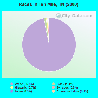
- 3,00996.8%White alone
- 431.4%Black alone
- 230.7%Hispanic
- 200.6%Two or more races
- 90.3%Asian alone
- 40.1%American Indian alone
Races in Ten Mile detailed stats: ancestries, foreign born residents, place of birth
According to our research of Tennessee and other state lists, there were 10 registered sex offenders living in Ten Mile, Tennessee as of May 16, 2024.
The ratio of all residents to sex offenders in Ten Mile is 327 to 1.
The ratio of registered sex offenders to all residents in this city is near the state average.
 Recent articles from our blog. Our writers, many of them Ph.D. graduates or candidates, create easy-to-read articles on a wide variety of topics.
Current Local Time: EST time zone
Land area: 61.4 square miles.
Population density: 53 people per square mile (very low).

| Ten Mile CCD: | 0.5% ($364) |
| Tennessee: | 0.8% ($715) |
Nearest city with pop. 50,000+: Knoxville, TN  (48.5 miles , pop. 173,890).
Nearest city with pop. 200,000+: Nashville-Davidson, TN (119.8 miles , pop. 545,524).
Nearest city with pop. 1,000,000+: Chicago, IL (456.7 miles , pop. 2,896,016).
Nearest cities:
), )Latitude: 35.66 N, Longitude: 84.71 W
Area code commonly used in this area: 423

| Here: | 4.6% |
| Tennessee: | 3.0% |
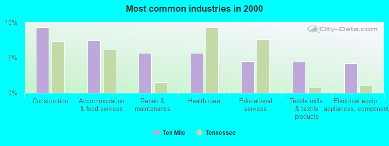
- Construction (9.3%)
- Accommodation & food services (7.5%)
- Repair & maintenance (5.7%)
- Health care (5.7%)
- Educational services (4.5%)
- Textile mills & textile products (4.4%)
- Electrical equipment, appliances, components (4.2%)

- Construction (14.6%)
- Repair & maintenance (6.7%)
- Accommodation & food services (6.0%)
- Transportation equipment (5.1%)
- Utilities (4.8%)
- Truck transportation (4.7%)
- Electrical equipment, appliances, components (4.4%)
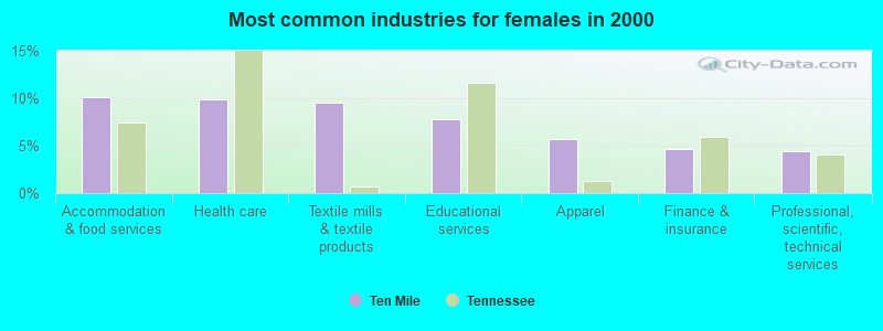
- Accommodation & food services (10.1%)
- Health care (9.8%)
- Textile mills & textile products (9.6%)
- Educational services (7.8%)
- Apparel (5.7%)
- Finance & insurance (4.7%)
- Professional, scientific, technical services (4.4%)
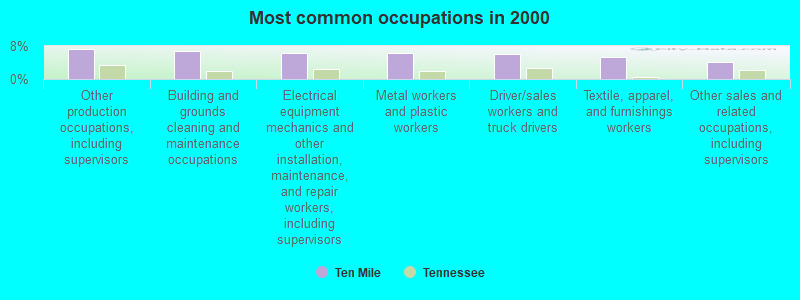
- Other production occupations, including supervisors (7.2%)
- Building and grounds cleaning and maintenance occupations (6.9%)
- Electrical equipment mechanics and other installation, maintenance, and repair workers, including supervisors (6.3%)
- Metal workers and plastic workers (6.2%)
- Driver/sales workers and truck drivers (6.0%)
- Textile, apparel, and furnishings workers (5.4%)
- Other sales and related occupations, including supervisors (4.0%)
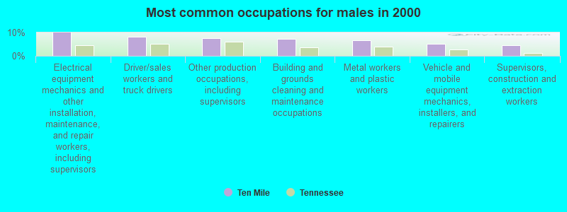
- Electrical equipment mechanics and other installation, maintenance, and repair workers, including supervisors (9.9%)
- Driver/sales workers and truck drivers (8.2%)
- Other production occupations, including supervisors (7.6%)
- Building and grounds cleaning and maintenance occupations (7.3%)
- Metal workers and plastic workers (6.7%)
- Vehicle and mobile equipment mechanics, installers, and repairers (5.1%)
- Supervisors, construction and extraction workers (4.7%)

- Textile, apparel, and furnishings workers (8.3%)
- Other sales and related occupations, including supervisors (7.3%)
- Other production occupations, including supervisors (6.5%)
- Building and grounds cleaning and maintenance occupations (6.2%)
- Health technologists and technicians (6.0%)
- Assemblers and fabricators (5.4%)
- Metal workers and plastic workers (5.4%)
Average climate in Ten Mile, Tennessee
Based on data reported by over 4,000 weather stations


(lower is better)
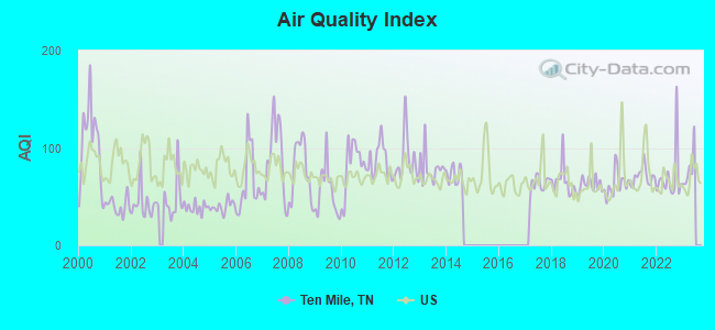
Air Quality Index (AQI) level in 2022 was 69.8. This is about average.
| City: | 69.8 |
| U.S.: | 72.6 |
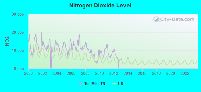
Nitrogen Dioxide (NO2) [ppb] level in 2012 was 7.30. This is significantly worse than average. Closest monitor was 14.4 miles away from the city center.
| City: | 7.30 |
| U.S.: | 5.11 |
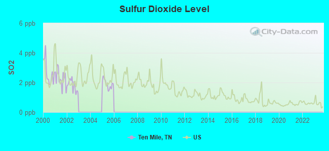
Sulfur Dioxide (SO2) [ppb] level in 2005 was 1.89. This is worse than average. Closest monitor was 4.1 miles away from the city center.
| City: | 1.89 |
| U.S.: | 1.51 |
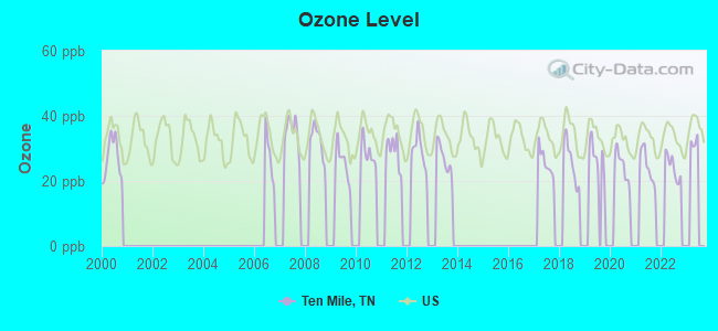
Ozone [ppb] level in 2022 was 24.2. This is better than average. Closest monitor was 18.8 miles away from the city center.
| City: | 24.2 |
| U.S.: | 33.3 |
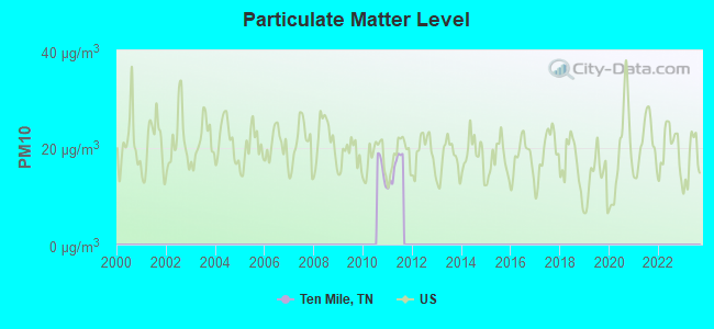
Particulate Matter (PM10) [µg/m3] level in 2011 was 15.8. This is better than average. Closest monitor was 14.7 miles away from the city center.
| City: | 15.8 |
| U.S.: | 19.2 |
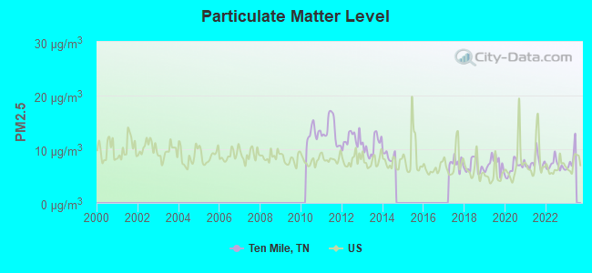
Particulate Matter (PM2.5) [µg/m3] level in 2022 was 7.01. This is about average. Closest monitor was 15.7 miles away from the city center.
| City: | 7.01 |
| U.S.: | 8.11 |
Tornado activity:
Ten Mile-area historical tornado activity is slightly below Tennessee state average. It is 1% smaller than the overall U.S. average.
On 5/2/1953, a category F4 (max. wind speeds 207-260 mph) tornado 8.7 miles away from the Ten Mile place center killed 4 people and injured 8 people and caused between $50,000 and $500,000 in damages.
On 4/8/1974, a category F3 (max. wind speeds 158-206 mph) tornado 16.5 miles away from the place center injured one person and caused between $50,000 and $500,000 in damages.
Earthquake activity:
Ten Mile-area historical earthquake activity is significantly above Tennessee state average. It is 104% greater than the overall U.S. average.On 11/30/1973 at 07:48:41, a magnitude 4.7 (4.7 MB, 4.6 ML, Class: Light, Intensity: IV - V) earthquake occurred 43.4 miles away from the city center
On 4/29/2003 at 08:59:39, a magnitude 4.9 (4.4 MB, 4.6 MW, 4.9 LG) earthquake occurred 95.6 miles away from Ten Mile center
On 12/12/2018 at 09:14:43, a magnitude 4.4 (4.4 MW, Depth: 4.9 mi) earthquake occurred 3.2 miles away from Ten Mile center
On 7/27/1980 at 18:52:21, a magnitude 5.2 (5.1 MB, 4.7 MS, 5.0 UK, 5.2 UK, Class: Moderate, Intensity: VI - VII) earthquake occurred 181.4 miles away from the city center
On 4/29/2003 at 08:59:39, a magnitude 4.6 (4.6 MW, Depth: 12.3 mi) earthquake occurred 95.6 miles away from the city center
On 4/18/2008 at 09:36:59, a magnitude 5.4 (5.1 MB, 4.8 MS, 5.4 MW, 5.2 MW) earthquake occurred 260.9 miles away from Ten Mile center
Magnitude types: regional Lg-wave magnitude (LG), body-wave magnitude (MB), local magnitude (ML), surface-wave magnitude (MS), moment magnitude (MW)
Natural disasters:
The number of natural disasters in Meigs County (13) is near the US average (15).Major Disasters (Presidential) Declared: 10
Emergencies Declared: 2
Causes of natural disasters: Floods: 8, Storms: 6, Tornadoes: 3, Winter Storms: 3, Flash Flood: 1, Heavy Rain: 1, Hurricane: 1, Ice Storm: 1, Snowfall: 1, Other: 1 (Note: some incidents may be assigned to more than one category).
Hospitals and medical centers near Ten Mile:
- SWEETWATER HOSP HOME HEALTH (Home Health Center, about 15 miles away; SWEETWATER, TN)
- SWEETWATER HOSPITAL ASSOCIATION Acute Care Hospitals (about 15 miles away; SWEETWATER, TN)
- (CLOSED) BAPTIST HOSPITAL OF ROANE COUNTY (Hospital, about 15 miles away; ROCKWOOD, TN)
- INTREPID USA HEALTHCARE SERVICES (Home Health Center, about 16 miles away; SWEETWATER, TN)
- FMC ATHENS (Dialysis Facility, about 16 miles away; ATHENS, TN)
- ARCON/BAPTIST HLTH CTR OF ROCKWOOD LLC (Hospital, about 16 miles away; ROCKWOOD, TN)
- NHC HEALTHCARE, ATHENS (Nursing Home, about 16 miles away; ATHENS, TN)
Operable nuclear power plant near Ten Mile:
- 9 miles: Watts Bar 1 in Spring City, TN.
Colleges/universities with over 2000 students nearest to Ten Mile:
- Roane State Community College (about 17 miles; Harriman, TN; Full-time enrollment: 4,302)
- Cleveland State Community College (about 33 miles; Cleveland, TN; FT enrollment: 2,500)
- Lee University (about 35 miles; Cleveland, TN; FT enrollment: 4,422)
- Pellissippi State Community College (about 37 miles; Knoxville, TN; FT enrollment: 7,271)
- Southern Adventist University (about 47 miles; Collegedale, TN; FT enrollment: 2,898)
- Chattanooga State Community College (about 49 miles; Chattanooga, TN; FT enrollment: 6,827)
- The University of Tennessee-Knoxville (about 49 miles; Knoxville, TN; FT enrollment: 25,483)
Public elementary/middle school in Ten Mile:
- MIDWAY MIDDLE SCHOOL (Students: 216, Location: 104 DOGTOWN RD, Grades: 6-8)
Points of interest:
Notable locations in Ten Mile: M and M Dock (A), Center Point (B), Sams Dock (C), Moss Fishing Dock (D), Camp Oo-tah-nee-noh-chee (E), Euchee Dock (F), Sewee Landing (G), Meigs County Emergency Services Fire Rescue Station 5 (H), Meigs County Emergency Services Fire Rescue Station 4 (I). Display/hide their locations on the map
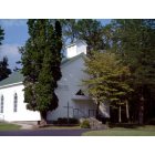
Churches in Ten Mile include: Ten Mile Methodist Church (A), Pleasant Hill Methodist Church (B), Peak Chapel (C), Maple Grove Church (D), Rocky Springs Church (E), Concord Church (F), Peakland Church (G), Hickory Flat Church (H), Oak Grove Church (I). Display/hide their locations on the map
Cemeteries: Hornsby Chapel (1), Huff Cemetery (2), Hutsell Cemetery (3), Sharp Cemetery (4), Turkeypen Cemetery (5), Johnson Cemetery (6), Wasson Cemetery (7). Display/hide their locations on the map
Reservoirs: Cupp Lake (A), Edgemon Lake (B). Display/hide their locations on the map
Streams, rivers, and creeks: Hurricane Creek (A), Watts Creek (B), Wann Branch (C), Dry Fork (D), Davis Creek (E), Dake Branch (F), Sewee Creek (G), Nebo Branch (H), Ten Mile Creek (I). Display/hide their locations on the map
Parks in Ten Mile include: Meigs County Park (1), Big Springs Access Area (2), Campground on the Lakeshore (3), Foshee Pass Recreation Area (4), Hornsby Hollow Recreation Area (5), Watts Bar Dam Recreation Area (6). Display/hide their locations on the map
| This place: | 2.5 people |
| Tennessee: | 2.5 people |
| This place: | 67.7% |
| Whole state: | 69.8% |
| This place: | 5.2% |
| Whole state: | 4.2% |
Likely homosexual households (counted as self-reported same-sex unmarried-partner households)
- Lesbian couples: 0.2% of all households
- Gay men: 0.2% of all households
| This place: | 16.2% |
| Whole state: | 13.5% |
| This place: | 7.4% |
| Whole state: | 5.8% |
Banks with branches in Ten Mile (2011 data):
- SouthEast Bank & Trust: Southeast Bank & Trust Ten Mile Offi at 2598 State Highway 304, branch established on 2006/05/15. Info updated 2007/04/23: Bank assets: $266.2 mil, Deposits: $233.4 mil, headquarters in Athens, TN, positive income, Commercial Lending Specialization, 8 total offices, Holding Company: Southeast Bancshares, Inc.
For population 15 years and over in Ten Mile:
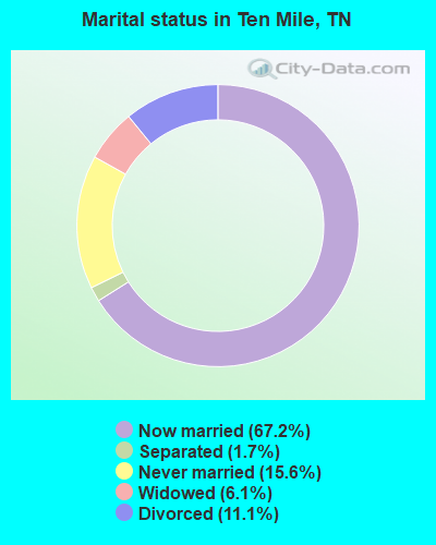
- Never married: 15.6%
- Now married: 67.2%
- Separated: 1.7%
- Widowed: 6.1%
- Divorced: 11.1%
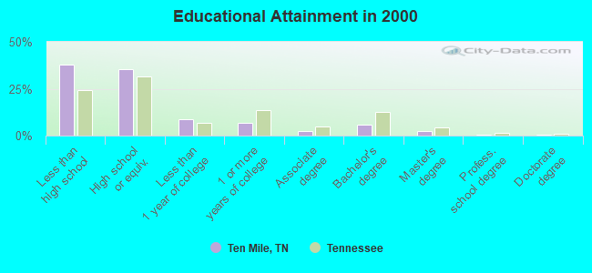
For population 25 years and over in Ten Mile:
- High school or higher: 62.1%
- Bachelor's degree or higher: 8.9%
- Graduate or professional degree: 3.2%
- Unemployed: 8.4%
- Mean travel time to work (commute): 37.8 minutes
| Here: | 13.4 |
| Tennessee average: | 13.3 |

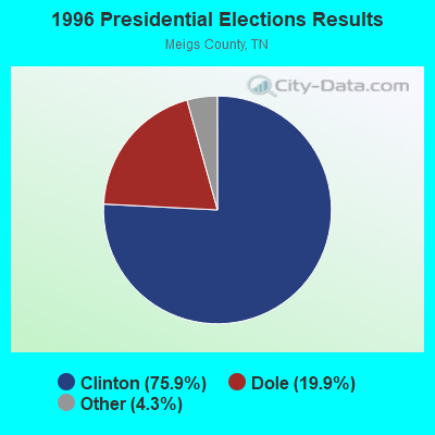
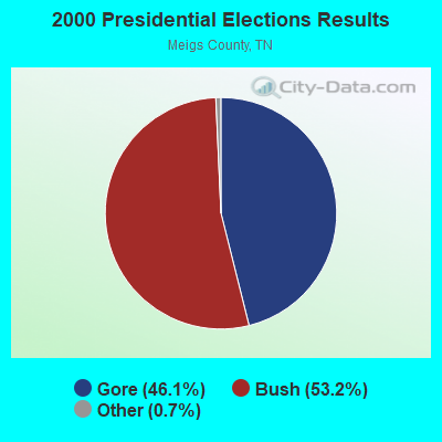


Graphs represent county-level data. Detailed 2008 Election Results
Religion statistics for Ten Mile, TN (based on Meigs County data)
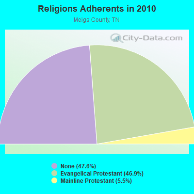
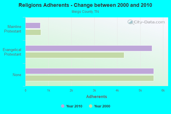
| Religion | Adherents | Congregations |
|---|---|---|
| Evangelical Protestant | 5,516 | 21 |
| Mainline Protestant | 644 | 9 |
| Other | - | 1 |
| None | 5,593 | - |
Food Environment Statistics:
| Meigs County: | 1.72 / 10,000 pop. |
| Tennessee: | 1.99 / 10,000 pop. |
| Meigs County: | 6.88 / 10,000 pop. |
| State: | 5.16 / 10,000 pop. |
| This county: | 3.44 / 10,000 pop. |
| State: | 6.56 / 10,000 pop. |
| Meigs County: | 11.6% |
| Tennessee: | 11.4% |
| This county: | 30.0% |
| State: | 30.2% |
| Meigs County: | 12.0% |
| Tennessee: | 13.5% |
Strongest AM radio stations in Ten Mile:
- WKVL (850 AM; daytime; 50 kW; KNOXVILLE, TN; Owner: HORNE RADIO, LLC)
- WFLI (1070 AM; 50 kW; LOOKOUT MOUNTAIN, TN; Owner: WFLI, INC.)
- WWAM (820 AM; daytime; 50 kW; JASPER, TN; Owner: SHELTON BROADCASTING SYSTEM)
- WOFE (580 AM; 1 kW; ROCKWOOD, TN; Owner: SOUTHERN MEDIA GROUP, INC.)
- WYXI (1390 AM; 2 kW; ATHENS, TN; Owner: CORNERSTONE BROADCASTING, INC.)
- WXQK (970 AM; 0 kW; SPRING CITY, TN; Owner: J.L. BREWER BROADCASTING OF CLEVELAND, LLC)
- WDEH (800 AM; 1 kW; SWEETWATER, TN; Owner: HORNE RADIO, LLC)
- WECO (940 AM; 5 kW; WARTBURG, TN; Owner: MORGAN COUNTY B/CASTING CO.)
- WSM (650 AM; 50 kW; NASHVILLE, TN; Owner: GAYLORD ENTERTAINMENT COMPANY)
- WCNN (680 AM; 50 kW; NORTH ATLANTA, GA; Owner: DICKEY BROADCASTING COMPANY)
- WQBB (1040 AM; daytime; 10 kW; POWELL, TN; Owner: JOURNAL BROADCAST CORPORATION)
- WGST (640 AM; 50 kW; ATLANTA, GA; Owner: CITICASTERS LICENSES, L.P.)
- WSB (750 AM; 50 kW; ATLANTA, GA; Owner: CXR HOLDINGS, INC.)
Strongest FM radio stations in Ten Mile:
- WAYA (93.9 FM; SPRING CITY, TN; Owner: J. L. BREWER BROADCASTING OF CLEVELAND, LLC)
- WWSR (105.7 FM; ROCKWOOD, TN; Owner: SOUTHERN MEDIA GROUP, INC.)
- WMKW (89.3 FM; CROSSVILLE, TN; Owner: THE MOODY BIBLE INSTITUTE OF CHICAGO)
- WKTS (90.1 FM; KINGSTON, TN; Owner: THE KINGSTON CENTURY CLUB INC.)
- WLLJ (103.1 FM; ETOWAH, TN; Owner: FRIENDSHIP BROADCASTING LLC.)
- WLOD-FM (98.3 FM; SWEETWATER, TN; Owner: HORNE RADIO, LLC)
- WOKI-FM (100.3 FM; OAK RIDGE, TN; Owner: OAK RIDGE FM, INC.)
- WJSQ (101.7 FM; ATHENS, TN; Owner: JAMES C. SLIGER)
- WBZH (92.7 FM; HARRIMAN, TN; Owner: SOUTHERN MEDIA GROUP, INC.)
- WDVX (89.9 FM; CLINTON, TN; Owner: CUMBERLAND COMMUNITIES COMMUNI CORP.)
- WDNT-FM (104.9 FM; DAYTON, TN; Owner: J. L. BREWER BROADCASTING OF CLEVELAND, LLC)
- WYGO (99.5 FM; MADISONVILLE, TN; Owner: MAJOR BROADCASTING CORPORATION)
- WOWF (102.5 FM; CROSSVILLE, TN; Owner: PEG BROADCASTING, INC.)
- WUSY (100.7 FM; CLEVELAND, TN; Owner: CAPSTAR TX LIMITED PARTNERSHIP)
- WCVP-FM (95.9 FM; ROBBINSVILLE, NC; Owner: CHEROKEE BROADCASTING COMPANY, INC.)
- WIVK-FM (107.7 FM; KNOXVILLE, TN; Owner: CITADEL BROADCASTING COMPANY)
- WUOT (91.9 FM; KNOXVILLE, TN; Owner: UNIVERSITY OF TENNESSEE)
- WWST (102.1 FM; SEVIERVILLE, TN; Owner: JOURNAL BROADCAST CORPORATION)
- WKZX-FM (93.5 FM; LENOIR CITY, TN; Owner: BP BROADCASTERS, LLC)
- WAYB-FM (95.7 FM; GRAYSVILLE, TN; Owner: FAMILY WORSHIP CENTER CHURCH, INC.)
TV broadcast stations around Ten Mile:
- WDTT-LP (Channel 38; LENOIR CITY, TN; Owner: WORD OF GOD FELLOWSHIP, INC.)
- WFLI-TV (Channel 53; CLEVELAND, TN; Owner: CHATTANOOGA MEDIA HOLDINGS, L.L.C.)
- W50AB (Channel 50; HIAWASSEE, GA; Owner: GEORGIA PUBLIC TELECOMMUNICATIONS COMMISSION)
- WBXX-TV (Channel 20; CROSSVILLE, TN; Owner: ACME TV LICENSES OF TENNESSEE, LLC)
- WVLT-TV (Channel 8; KNOXVILLE, TN; Owner: WVLT LICENSEE CORP.)
- WKOP-TV (Channel 15; KNOXVILLE, TN; Owner: EAST TENNESSEE PUBLIC COMMUNICATIONS CORP.)
- WBIR-TV (Channel 10; KNOXVILLE, TN; Owner: GANNETT PACIFIC CORPORATION)
- WATE-TV (Channel 6; KNOXVILLE, TN; Owner: WATE, G.P.)
- W46DC (Channel 46; KNOXVILLE, TN; Owner: TRINITY BROADCASTING NETWORK)
- WTNZ (Channel 43; KNOXVILLE, TN; Owner: RAYCOM AMERICA, INC.)
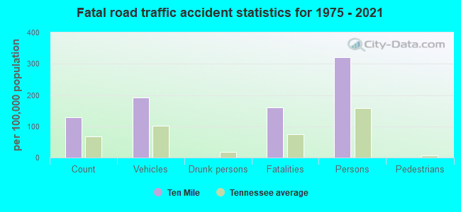
Ten Mile fatal accident list:
Sep 6, 2008 07:39 PM, Sr-68, Sr-304, Lat: 35.624120, Lon: -84.764370, Vehicles: 2, Persons: 4, Fatalities: 2
Sep 11, 2005 08:45 PM, Sr-68, Sr-304, Lat: 35.623220, Lon: -84.754630, Vehicles: 2, Persons: 2, Fatalities: 1
Oct 7, 2002 06:41 PM, Plesanthillrd, Vehicles: 1, Persons: 1, Fatalities: 1
FCC Registered Antenna Towers:
23 (See the full list of FCC Registered Antenna Towers in Ten Mile)FCC Registered Amateur Radio Licenses:
45 (See the full list of FCC Registered Amateur Radio Licenses in Ten Mile)FAA Registered Aircraft:
3- Aircraft: PIPER PA-28-140 (Category: Land, Seats: 4, Weight: Up to 12,499 Pounds, Speed: 107 mph), Engine: Reciprocating
N-Number: 140SD, N140SD, N-140SD, Serial Number: 28-22963, Certificate Issue Date: 08/14/2012
Registrant (Individual): David A Beeson, 125 Brown Rd, Ten Mile, TN 37880 - Aircraft: MCEWEN DICK L RV-7A (Category: Land, Seats: 2, Weight: Up to 12,499 Pounds), Engine: AMA/EXPR UNKNOWN ENG (Reciprocating)
N-Number: 453DM, N453DM, N-453DM, Serial Number: 71963, Year manufactured: 2009, Airworthiness Date: 04/13/2009, Certificate Issue Date: 07/29/2013
Registrant (Co-Owned): Robert G Braaf, 4397 River Rd, Ten Mile, TN 37880, Other Owners: Chris A Braaf - Aircraft: MOONEY M20C (Category: Land, Seats: 4, Weight: Up to 12,499 Pounds, Speed: 127 mph), Engine: LYCOMING O&VO-360 SER (180 HP) (Reciprocating)
N-Number: 6899U, N6899U, N-6899U, Serial Number: 2603, Year manufactured: 1963, Airworthiness Date: 08/20/1963, Certificate Issue Date: 07/29/2020
Registrant (Individual): Clayton E Mayo, 2013 Pleasant Hill Rd, Ten Mile, TN 37880
2004 - 2018 National Fire Incident Reporting System (NFIRS) incidents
- Fire incident types reported to NFIRS in Ten Mile, TN
- 14045.3%Structure Fires
- 13242.7%Outside Fires
- 3310.7%Mobile Property/Vehicle Fires
- 41.3%Other
 According to the data from the years 2004 - 2018 the average number of fire incidents per year is 21. The highest number of reported fires - 39 took place in 2013, and the least - 0 in 2006. The data has a rising trend.
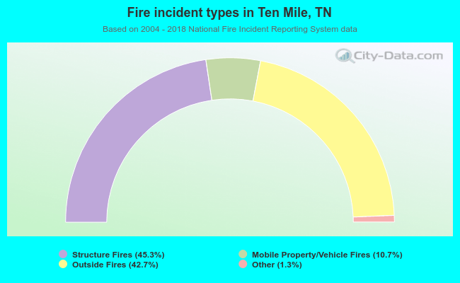 When looking into fire subcategories, the most incidents belonged to: Structure Fires (45.3%), and Outside Fires (42.7%).
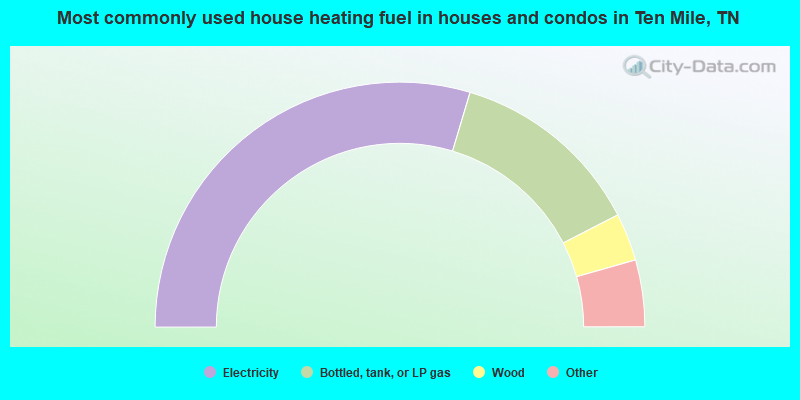
- 59.2%Electricity
- 25.6%Bottled, tank, or LP gas
- 6.3%Wood
- 3.5%Other fuel
- 2.6%Fuel oil, kerosene, etc.
- 2.1%Utility gas
- 0.7%No fuel used
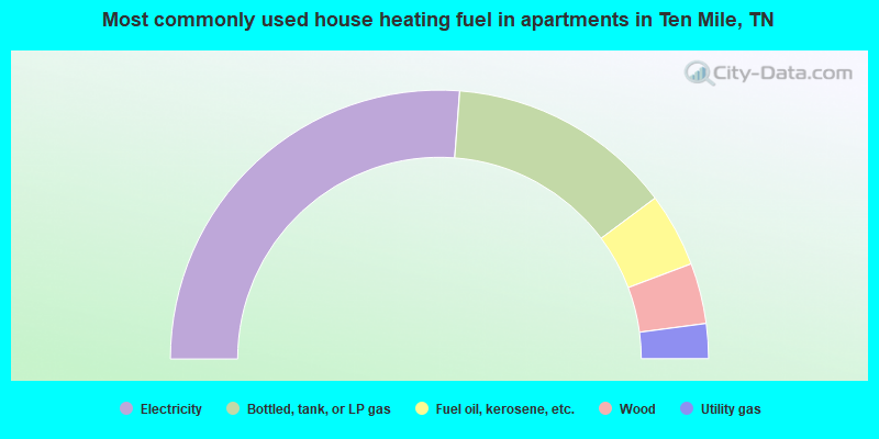
- 52.4%Electricity
- 27.2%Bottled, tank, or LP gas
- 8.9%Fuel oil, kerosene, etc.
- 7.3%Wood
- 4.2%Utility gas
Ten Mile compared to Tennessee state average:
- Median house value below state average.
- Black race population percentage significantly below state average.
- Hispanic race population percentage significantly below state average.
- Foreign-born population percentage significantly below state average.
- Renting percentage significantly below state average.
- Length of stay since moving in significantly above state average.
- Number of rooms per house significantly below state average.
- House age significantly below state average.
- Number of college students below state average.
- Percentage of population with a bachelor's degree or higher significantly below state average.

|
Total of 7 patent applications in 2008-2024.