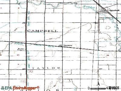
Tenney, Minnesota
Submit your own pictures of this city and show them to the world
- OSM Map
- General Map
- Google Map
- MSN Map

Population change since 2000: -16.7%
 |
| Males: 2 | |
| Females: 3 |
| Median resident age: | 44.3 years |
| Minnesota median age: | 39.0 years |
Zip code: 56583
| Tenney: | $15,055 |
| MN: | $82,338 |
Estimated per capita income in 2022: $18,197 (it was $8,000 in 2000)
Estimated median house or condo value in 2022: $28,667 (it was $9,999 in 2000)
| Tenney: | $28,667 |
| MN: | $314,600 |


 Recent articles from our blog. Our writers, many of them Ph.D. graduates or candidates, create easy-to-read articles on a wide variety of topics.

 | Unusual but Fun Places to Visit (46 replies) |
Latest news from Tenney, MN collected exclusively by city-data.com from local newspapers, TV, and radio stations
Ancestries: German (16.7%).
Current Local Time: CST time zone
Incorporated on 11/30/1901
Elevation: 990 feet
Land area: 0.02 square miles.
Population density: 248 people per square mile (very low).

| Tenney city: | 2.0% ($199) |
| Minnesota: | 1.1% ($1,297) |
Nearest city with pop. 50,000+: Fargo, ND  (59.7 miles , pop. 90,599).
Nearest city with pop. 200,000+: Minneapolis, MN (171.5 miles , pop. 382,618).
Nearest city with pop. 1,000,000+: Chicago, IL (524.4 miles , pop. 2,896,016).
Nearest cities:
), ), Latitude: 46.04 N, Longitude: 96.45 W
Area code commonly used in this area: 218

| Here: | 1.9% |
| Minnesota: | 2.6% |
Average climate in Tenney, Minnesota
Based on data reported by over 4,000 weather stations


Tornado activity:
Tenney-area historical tornado activity is slightly below Minnesota state average. It is 11% smaller than the overall U.S. average.
On 5/10/1982, a category F3 (max. wind speeds 158-206 mph) tornado 1.8 miles away from the Tenney city center caused between $500,000 and $5,000,000 in damages.
On 5/5/1964, a category F3 tornado 7.0 miles away from the city center injured 11 people and caused between $500 and $5000 in damages.
Earthquake activity:
Tenney-area historical earthquake activity is significantly above Minnesota state average. It is 20% smaller than the overall U.S. average.On 7/9/1975 at 14:54:15, a magnitude 4.6 (4.6 MB, Class: Light, Intensity: IV - V) earthquake occurred 32.7 miles away from Tenney center
On 6/5/1993 at 01:24:53, a magnitude 4.1 (4.1 LG, Depth: 6.2 mi) earthquake occurred 26.8 miles away from the city center
On 3/4/1983 at 06:32:18, a magnitude 4.6 (4.4 MB, 4.6 LG, 4.4 ML) earthquake occurred 191.8 miles away from the city center
On 10/20/1995 at 15:57:18, a magnitude 3.7 (3.7 LG, Depth: 3.1 mi, Class: Light, Intensity: II - III) earthquake occurred 26.5 miles away from Tenney center
On 8/18/1959 at 06:37:13, a magnitude 7.7 (7.7 UK, Class: Major, Intensity: VIII - XII) earthquake occurred 697.4 miles away from Tenney center, causing $26,000,000 total damage
On 11/3/2002 at 20:41:56, a magnitude 4.3 (4.3 MB, Depth: 3.1 mi) earthquake occurred 256.7 miles away from Tenney center
Magnitude types: regional Lg-wave magnitude (LG), body-wave magnitude (MB), local magnitude (ML)
Natural disasters:
The number of natural disasters in Wilkin County (22) is greater than the US average (15).Major Disasters (Presidential) Declared: 16
Emergencies Declared: 4
Causes of natural disasters: Floods: 17, Storms: 9, Winds: 3, Winter Storms: 3, Tornadoes: 2, Blizzard: 1, Drought: 1, Hurricane: 1, Snow: 1, Other: 1 (Note: some incidents may be assigned to more than one category).
Airports located in Tenney:
- Wetherbee Farm Airport (1MN0) (Runways: 1)
Colleges/universities with over 2000 students nearest to Tenney:
- North Dakota State College of Science (about 18 miles; Wahpeton, ND; Full-time enrollment: 2,318)
- Minnesota State Community and Technical College (about 25 miles; Fergus Falls, MN; FT enrollment: 4,863)
- Alexandria Technical & Community College (about 54 miles; Alexandria, MN; FT enrollment: 2,324)
- Concordia College at Moorhead (about 59 miles; Moorhead, MN; FT enrollment: 2,767)
- Minnesota State University-Moorhead (about 59 miles; Moorhead, MN; FT enrollment: 6,096)
- North Dakota State University-Main Campus (about 62 miles; Fargo, ND; FT enrollment: 12,680)
- Ridgewater College (about 92 miles; Willmar, MN; FT enrollment: 3,288)
Points of interest:
| This city: | 2.5 people |
| Minnesota: | 2.5 people |
| This city: | 100.0% |
| Whole state: | 64.6% |
| This city: | 0.0% |
| Whole state: | 6.9% |
No gay or lesbian households reported
For population 15 years and over in Tenney:

- Never married: 50.1%
- Now married: 0.0%
- Separated: 0.0%
- Widowed: 0.0%
- Divorced: 49.9%
For population 25 years and over in Tenney:
- High school or higher: 100.0%
- Bachelor's degree or higher: 0.0%
- Graduate or professional degree: 0.0%
- Mean travel time to work (commute): 10.0 minutes

| Here: | 2.4 |
| Minnesota average: | 10.9 |
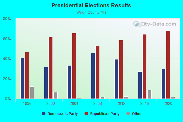
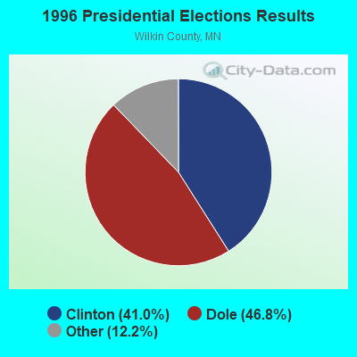
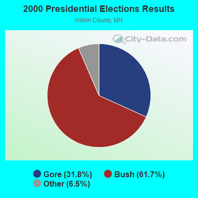
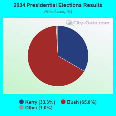
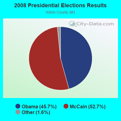
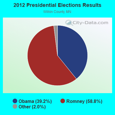
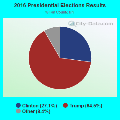
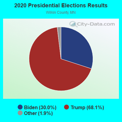
Graphs represent county-level data. Detailed 2008 Election Results
Religion statistics for Tenney, MN (based on Wilkin County data)
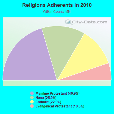
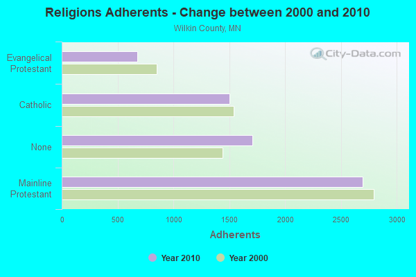
| Religion | Adherents | Congregations |
|---|---|---|
| Mainline Protestant | 2,691 | 10 |
| Catholic | 1,503 | 2 |
| Evangelical Protestant | 676 | 6 |
| Other | 1 | 1 |
| None | 1,705 | - |
Food Environment Statistics:
| This county: | 4.68 / 10,000 pop. |
| State: | 3.90 / 10,000 pop. |
| This county: | 6.24 / 10,000 pop. |
| Minnesota: | 6.98 / 10,000 pop. |
| This county: | 7.4% |
| Minnesota: | 6.5% |
| This county: | 27.6% |
| Minnesota: | 25.9% |
| Wilkin County: | 3.0% |
| Minnesota: | 13.0% |
| Local government employment and payroll (March 2012) | |||||
| Function | Full-time employees | Monthly full-time payroll | Average yearly full-time wage | Part-time employees | Monthly part-time payroll |
|---|---|---|---|---|---|
| Other Government Administration | 0 | $0 | 0 | $0 | |
| Totals for Government | 0 | $0 | 0 | $0 | |
Strongest AM radio stations in Tenney:
- KBRF (1250 AM; 10 kW; FERGUS FALLS, MN; Owner: RESULT RADIO, INC.)
- KPRM (870 AM; 25 kW; PARK RAPIDS, MN; Owner: DE LA HUNT BROADCASTING CORP.)
- KJJK (1020 AM; 2 kW; FERGUS FALLS, MN; Owner: RESULT RADIO, INC.)
- KFNW (1200 AM; 10 kW; WEST FARGO, ND; Owner: NORTHWESTERN COLLEGE)
- WWNL (1080 AM; 50 kW; PITTSBURGH, PA; Owner: STEEL CITY RADIO, INC.)
- KFGO (790 AM; 5 kW; FARGO, ND; Owner: CAPSTAR TX LIMITED PARTNERSHIP)
- KBMW (1450 AM; 1 kW; BRECKENRIDGE, MN; Owner: MONTEREY LICENSES, LLC)
- WCCO (830 AM; 50 kW; MINNEAPOLIS, MN; Owner: INFINITY MEDIA CORPORATION)
- WEBC (560 AM; 50 kW; DULUTH, MN)
- KXMR (710 AM; 50 kW; BISMARCK, ND; Owner: RADIO BISMARCK MANDAN, LLC)
- KQWB (1660 AM; 10 kW; WEST FARGO, ND; Owner: MONTEREY LICENSES, LLC)
- KFAN (1130 AM; 50 kW; MINNEAPOLIS, MN; Owner: AMFM RADIO LICENSES, L.L.C.)
- WDAY (970 AM; 5 kW; FARGO, ND; Owner: FORUM COMMUNICATIONS COMPANY)
Strongest FM radio stations in Tenney:
- KJJK-FM (96.5 FM; FERGUS FALLS, MN; Owner: RESULT RADIO, INC.)
- KZCR (103.3 FM; FERGUS FALLS, MN; Owner: RESULT RADIO, INC)
- KLTA (105.1 FM; BRECKENRIDGE, MN; Owner: MONTEREY LICENSES, LLC)
- KNWF (91.5 FM; FERGUS FALLS, MN; Owner: MINNESOTA PUBLIC RADIO)
TV broadcast stations around Tenney:
- K27EN (Channel 27; DONNELLY, MN; Owner: FEDERATED TELEPHONE COOPERATIVE)
- K39DZ (Channel 39; DONNELLY, MN; Owner: FEDERATED TELEPHONE COOPERATIVE)
- K45DP (Channel 45; DONNELLY, MN; Owner: FEDERATED TELEPHONE COOPERATIVE)
- K51EJ (Channel 51; DONNELLY, MN; Owner: FEDERATED TELEPHONE COOPERATIVE)
- K18DU (Channel 18; DONNELLY, MN; Owner: TRI-COUNTY UHF-TV, INC.)
- K55FW (Channel 55; DONNELLY, MN; Owner: FEDERATED TELEPHONE COOPERATIVE)
- K57BL (Channel 57; DONNELLY, MN; Owner: FEDERATED TELEPHONE COOPERATIVE)
- K31DH (Channel 31; DONNELLY, MN; Owner: TRI-COUNTY UHF-TV, INC.)
- K53DX (Channel 53; DONNELLY, MN; Owner: FEDERATED TELEPHONE COOPERATIVE)
- K59BT (Channel 59; DONNELLY, MN; Owner: FEDERATED TELEPHONE COOPERATIVE)
- K61BJ (Channel 61; DONNELLY, MN; Owner: FEDERATED TELEPHONE COOPERATIVE)
- K63BW (Channel 63; DONNELLY/HERMAN, MN; Owner: FEDERATED TELEPHONE COOPERATIVE)
FCC Registered Antenna Towers:
1- 3/4 Mi S Of Jct Hwy 75 & 55 (Lat: 46.039167 Lon: -96.494444), Type: 73.1, Overall height: 73.1 m, Registrant: Wahpe-ton, Phone: (701) 692-4435
FCC Registered Broadcast Land Mobile Towers:
1- Traverse County Section 14 Of Taylor Township Off Hwy 95 (Lat: 46.091639 Lon: -96.537583), Call Sign: KNCB552,
Assigned Frequencies: 158.325 MHz, Grant Date: 01/14/1997, Expiration Date: 12/16/2001, Cancellation Date: 05/05/2002, Registrant: Timothy Zentgraf, 525 12th St N, Breckenridge, MN 56520, Phone: (218) 643-4403
FCC Registered Microwave Towers:
2- 2 Mi W, .25 Mi S (Lat: 46.039389 Lon: -96.493944), Structure height: 77.1 m, Call Sign: KXX24,
Assigned Frequencies: 6925.00 MHz, Grant Date: 03/29/1967, Expiration Date: 04/01/1983, Cancellation Date: 06/11/2000, Registrant: North Central Educational Television Inc, Hwy 81 S, Fargo, ND 58102
- 2 Mi W, .25 Mi S Of (Lat: 46.039389 Lon: -96.493944), Structure height: 77.1 m, Call Sign: KXX25,
Assigned Frequencies: 6975.00 MHz, Grant Date: 03/29/1967, Expiration Date: 04/01/1983, Cancellation Date: 06/11/2000, Registrant: North Central Educational Television Inc, Hwy 81 S, Fargo, ND 58102

- 100.0%Electricity
Tenney compared to Minnesota state average:
- Median household income significantly below state average.
- Median house value significantly below state average.
- Unemployed percentage significantly below state average.
- Black race population percentage significantly below state average.
- Hispanic race population percentage significantly below state average.
- Median age significantly above state average.
- Foreign-born population percentage significantly below state average.
- Renting percentage significantly below state average.
- Length of stay since moving in significantly above state average.
- Number of rooms per house significantly below state average.
- House age significantly above state average.
- Number of college students significantly below state average.
- Percentage of population with a bachelor's degree or higher significantly below state average.