Thornton, California
Submit your own pictures of this place and show them to the world
- OSM Map
- General Map
- Google Map
- MSN Map

| Males: 2,838 | |
| Females: 2,608 |
| Median resident age: | 34.5 years |
| California median age: | 33.3 years |
Zip code: 95242
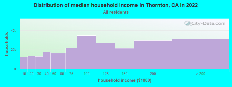
| Thornton: | $91,201 |
| CA: | $91,551 |
Estimated per capita income in 2022: $43,341 (it was $21,215 in 2000)
Thornton CCD income, earnings, and wages data
Estimated median house or condo value in 2022: $550,747 (it was $143,700 in 2000)
| Thornton: | $550,747 |
| CA: | $715,900 |
Mean prices in 2022: all housing units: $555,132; detached houses: $579,147; townhouses or other attached units: $413,977; in 2-unit structures: $846,717; in 3-to-4-unit structures: $323,925; in 5-or-more-unit structures: $223,694; mobile homes: $155,998; occupied boats, rvs, vans, etc.: $9,512
Detailed information about poverty and poor residents in Thornton, CA
Compare current foreclosures near Thornton, CA:
| Photo | Address | Area | Beds / Baths | Price | Details |
|---|---|---|---|---|---|

|
#1
Vineyard Dr
Lodi, CA 95240
|
1,225 sq. feet
|
2 baths 3 beds |
$370,000
|
show details |

|
#2
E Bianchi Rd Apt 2
Stockton, CA 95207
|
840 sq. feet
|
1 baths 2 beds |
$175,000
|
show details |

|
#3
Quail Lakes Dr Apt 126
Stockton, CA 95207
|
612 sq. feet
|
1 baths 1 beds |
$175,000
|
show details |

|
#4
W Highway 12
Lodi, CA 95242
|
1,591 sq. feet
|
1 baths 2 beds |
show details | |

|
#5
W Harding Way
Stockton, CA 95204
|
2,029 sq. feet
|
2 baths 4 beds |
show details | |

|
#6
N 4th St
Rio Vista, CA 94571
|
1,271 sq. feet
|
1 baths 2 beds |
show details | |

|
#7
Mccoy Ct Apt 59
Lodi, CA 95240
|
855 sq. feet
|
1 baths 2 beds |
show details | |

|
#8
W Poplar St
Stockton, CA 95203
|
1,335 sq. feet
|
1 baths 2 beds |
show details | |

|
#9
Costantino Cir
Stockton, CA 95212
|
2,270 sq. feet
|
2 baths 4 beds |
show details | |

|
#10
Ivywood Dr
Galt, CA 95632
|
1,581 sq. feet
|
2 baths 4 beds |
show details |
| Photo | Address | Area | Beds / Baths | Price | Details |
|---|---|---|---|---|---|

|
#11
De Flores Cir
Rio Vista, CA 94571
|
1,617 sq. feet
|
2 baths 4 beds |
show details | |

|
#12
Saunders Ct
Galt, CA 95632
|
3,094 sq. feet
|
5 baths 5 beds |
show details | |

|
#13
Koni Ct
Lodi, CA 95240
|
2,362 sq. feet
|
2 baths 3 beds |
show details | |

|
#14
Atlanta Cir
Stockton, CA 95219
|
- sq. feet
|
2 baths 3 beds |
show details | |

|
#15
S Regent St
Stockton, CA 95204
|
1,439 sq. feet
|
1 baths 3 beds |
show details | |

|
#16
Bristol Ave
Stockton, CA 95204
|
1,742 sq. feet
|
1 baths 3 beds |
show details | |

|
#17
N Country Club Blvd
Stockton, CA 95204
|
1,615 sq. feet
|
2 baths 3 beds |
show details | |

|
#18
Herndon Pl
Stockton, CA 95219
|
- sq. feet
|
1 baths 3 beds |
show details | |

|
#19
N 5th St
Rio Vista, CA 94571
|
1,372 sq. feet
|
2 baths 2 beds |
show details | |

|
#20
Flores Way
Rio Vista, CA 94571
|
1,161 sq. feet
|
2 baths 3 beds |
show details |
| Photo | Address | Area | Beds / Baths | Price | Details |
|---|---|---|---|---|---|

|
#21
N Filbert St
Stockton, CA 95205
|
1,075 sq. feet
|
2 baths 2 beds |
show details | |

|
#22
Poplar Dr
Oakley, CA 94561
|
3,341 sq. feet
|
3 baths 4 beds |
show details | |

|
#23
Palisades Dr
Rio Vista, CA 94571
|
1,172 sq. feet
|
2 baths 2 beds |
show details | |

|
#24
Turnberry Ter
Rio Vista, CA 94571
|
970 sq. feet
|
2 baths 2 beds |
show details | |

|
#25
W Brannan Island Rd
Isleton, CA 95641
|
- sq. feet
|
2 baths 3 beds |
show details | |

|
#26
Cherry Hills Pl
Stockton, CA 95209
|
2,376 sq. feet
|
3 baths 5 beds |
show details | |

|
#27
Cedar Ridge Dr
Rio Vista, CA 94571
|
1,105 sq. feet
|
2 baths 2 beds |
show details | |

|
#28
Brockton Pl
Rio Vista, CA 94571
|
1,767 sq. feet
|
2 baths 2 beds |
show details | |

|
#29
Brockton Pl
Rio Vista, CA 94571
|
1,420 sq. feet
|
2 baths 2 beds |
show details | |

|
#30
Shasta Dr
Rio Vista, CA 94571
|
1,218 sq. feet
|
2 baths 4 beds |
show details |
| Photo | Address | Area | Beds / Baths | Price | Details |
|---|---|---|---|---|---|

|
#31
Trieste Cir
Stockton, CA 95205
|
1,449 sq. feet
|
2 baths 3 beds |
show details | |

|
#32
Myran Ave
Stockton, CA 95205
|
1,025 sq. feet
|
1 baths 2 beds |
show details | |

|
#33
Waudman Ave
Stockton, CA 95209
|
1,503 sq. feet
|
2 baths 3 beds |
show details | |

|
#34
Shirleen Dr
Stockton, CA 95209
|
2,837 sq. feet
|
3 baths 4 beds |
show details | |

|
#35
Chaparral Way
Stockton, CA 95209
|
2,134 sq. feet
|
2 baths 4 beds |
show details | |

|
#36
Rubier Way
Rio Vista, CA 94571
|
1,617 sq. feet
|
2 baths 4 beds |
show details | |

|
#37
Ashburn Dr
Stockton, CA 95209
|
1,835 sq. feet
|
2 baths 4 beds |
show details | |

|
#38
Chaparral Way
Stockton, CA 95209
|
1,519 sq. feet
|
2 baths 3 beds |
show details | |

|
#39
Clipper Ln
Stockton, CA 95204
|
1,402 sq. feet
|
2 baths 3 beds |
show details | |

|
#40
S Cherokee Ln Apt 45
Lodi, CA 95240
|
960 sq. feet
|
1 baths 2 beds |
show details |
| Photo | Address | Area | Beds / Baths | Price | Details |
|---|---|---|---|---|---|

|
#41
4th St
Isleton, CA 95641
|
1,634 sq. feet
|
2 baths 4 beds |
show details | |

|
#42
W Mayfair Ave
Stockton, CA 95207
|
1,104 sq. feet
|
1 baths 3 beds |
show details | |

|
#43
Clinton Dr
Stockton, CA 95210
|
1,503 sq. feet
|
2 baths 3 beds |
show details | |

|
#44
Homewood Dr
Stockton, CA 95210
|
912 sq. feet
|
1 baths 2 beds |
show details | |

|
#45
E Robinhood Dr
Stockton, CA 95207
|
960 sq. feet
|
1 baths 3 beds |
show details | |

|
#46
Orr Rd
Galt, CA 95632
|
1,372 sq. feet
|
2 baths 3 beds |
show details | |

|
#47
Caroline Ave
Galt, CA 95632
|
2,354 sq. feet
|
2 baths 3 beds |
show details | |

|
#48
Edelweiss Way
Galt, CA 95632
|
2,350 sq. feet
|
3 baths 4 beds |
show details | |

|
#49
Mcfarland St
Galt, CA 95632
|
1,452 sq. feet
|
2 baths 3 beds |
show details | |

|
Check over 1 million property listings on Foreclosure.com!
|
browse all offers | |||


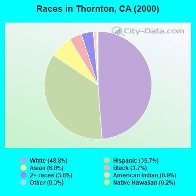
- 2,26948.8%White alone
- 1,65935.7%Hispanic
- 3166.8%Asian alone
- 1733.7%Black alone
- 1693.6%Two or more races
- 420.9%American Indian alone
- 150.3%Other race alone
- 70.2%Native Hawaiian and Other
Pacific Islander alone
 Recent articles from our blog. Our writers, many of them Ph.D. graduates or candidates, create easy-to-read articles on a wide variety of topics.
Current Local Time: PST time zone
Elevation: 11 feet
Land area: 112.6 square miles.
Population density: 48 people per square mile (very low).

| Thornton CCD: | 1.4% ($2,082) |
| California: | 0.8% ($1,564) |
Nearest city with pop. 50,000+: Lodi, CA  (8.5 miles , pop. 56,999).
Nearest city with pop. 200,000+: Stockton, CA (13.1 miles , pop. 243,771).
Nearest city with pop. 1,000,000+: Los Angeles, CA (327.9 miles , pop. 3,694,820).
Nearest cities:
), ), ), ), ), )Latitude: 38.13 N, Longitude: 121.44 W
Area code: 209

| Here: | 6.8% |
| California: | 5.1% |
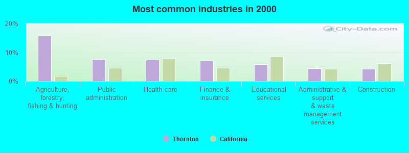
- Agriculture, forestry, fishing & hunting (15.8%)
- Public administration (7.5%)
- Health care (7.4%)
- Finance & insurance (7.1%)
- Educational services (5.9%)
- Administrative & support & waste management services (4.4%)
- Construction (4.3%)
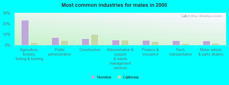
- Agriculture, forestry, fishing & hunting (23.4%)
- Public administration (7.2%)
- Construction (6.2%)
- Administrative & support & waste management services (4.7%)
- Finance & insurance (4.5%)
- Truck transportation (4.2%)
- Motor vehicle & parts dealers (4.1%)
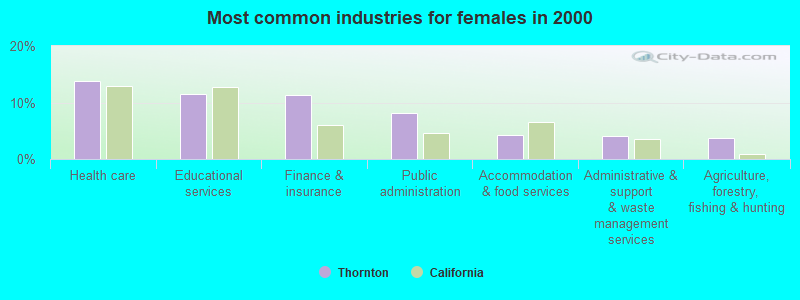
- Health care (13.7%)
- Educational services (11.5%)
- Finance & insurance (11.3%)
- Public administration (8.1%)
- Accommodation & food services (4.2%)
- Administrative & support & waste management services (4.0%)
- Agriculture, forestry, fishing & hunting (3.8%)
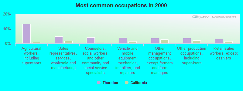
- Agricultural workers, including supervisors (13.3%)
- Sales representatives, services, wholesale and manufacturing (4.8%)
- Counselors, social workers, and other community and social service specialists (4.1%)
- Vehicle and mobile equipment mechanics, installers, and repairers (3.9%)
- Other management occupations, except farmers and farm managers (3.8%)
- Other production occupations, including supervisors (3.7%)
- Retail sales workers, except cashiers (3.1%)
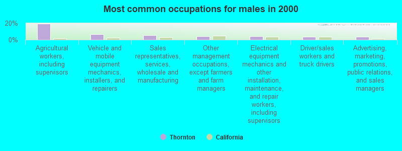
- Agricultural workers, including supervisors (19.2%)
- Vehicle and mobile equipment mechanics, installers, and repairers (6.4%)
- Sales representatives, services, wholesale and manufacturing (5.3%)
- Other management occupations, except farmers and farm managers (4.3%)
- Electrical equipment mechanics and other installation, maintenance, and repair workers, including supervisors (4.3%)
- Driver/sales workers and truck drivers (3.9%)
- Advertising, marketing, promotions, public relations, and sales managers (3.4%)
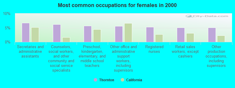
- Secretaries and administrative assistants (6.7%)
- Counselors, social workers, and other community and social service specialists (6.1%)
- Preschool, kindergarten, elementary, and middle school teachers (5.6%)
- Other office and administrative support workers, including supervisors (5.5%)
- Registered nurses (5.3%)
- Retail sales workers, except cashiers (5.0%)
- Other production occupations, including supervisors (5.0%)
Average climate in Thornton, California
Based on data reported by over 4,000 weather stations


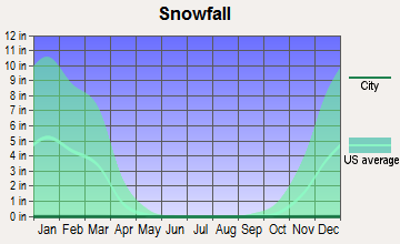


(lower is better)
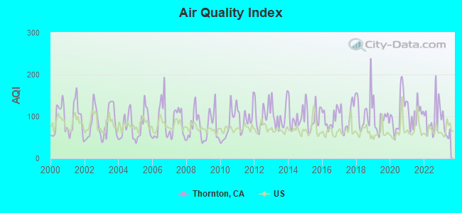
Air Quality Index (AQI) level in 2023 was 71.8. This is about average.
| City: | 71.8 |
| U.S.: | 72.6 |
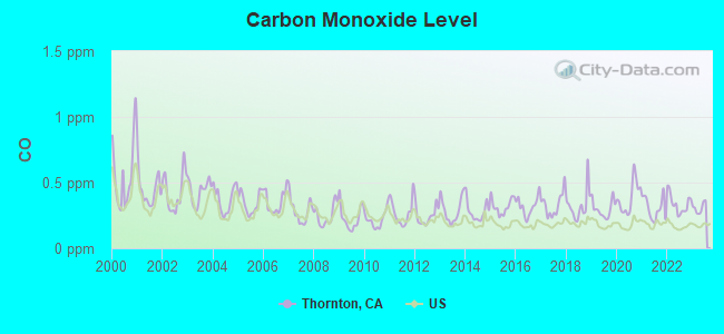
Carbon Monoxide (CO) [ppm] level in 2023 was 0.308. This is worse than average. Closest monitor was 8.3 miles away from the city center.
| City: | 0.308 |
| U.S.: | 0.251 |
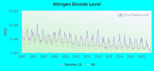
Nitrogen Dioxide (NO2) [ppb] level in 2023 was 3.36. This is significantly better than average. Closest monitor was 11.9 miles away from the city center.
| City: | 3.36 |
| U.S.: | 5.11 |
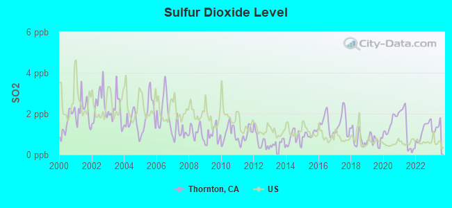
Sulfur Dioxide (SO2) [ppb] level in 2023 was 1.32. This is about average. Closest monitor was 14.1 miles away from the city center.
| City: | 1.32 |
| U.S.: | 1.51 |
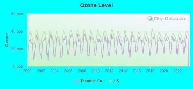
Ozone [ppb] level in 2023 was 28.7. This is about average. Closest monitor was 8.3 miles away from the city center.
| City: | 28.7 |
| U.S.: | 33.3 |
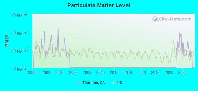
Particulate Matter (PM10) [µg/m3] level in 2022 was 25.0. This is worse than average. Closest monitor was 8.4 miles away from the city center.
| City: | 25.0 |
| U.S.: | 19.2 |
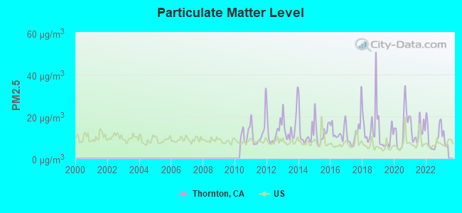
Particulate Matter (PM2.5) [µg/m3] level in 2022 was 10.3. This is worse than average. Closest monitor was 14.5 miles away from the city center.
| City: | 10.3 |
| U.S.: | 8.1 |
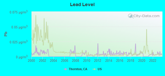
Lead (Pb) [µg/m3] level in 2023 was 0.00414. This is significantly better than average. Closest monitor was 9.4 miles away from the city center.
| City: | 0.00414 |
| U.S.: | 0.00931 |
Earthquake activity:
Thornton-area historical earthquake activity is significantly above California state average. It is 7881% greater than the overall U.S. average.On 4/18/1906 at 13:12:21, a magnitude 7.9 (7.9 UK, Class: Major, Intensity: VIII - XII) earthquake occurred 85.5 miles away from Thornton center, causing $524,000,000 total damage
On 10/18/1989 at 00:04:15, a magnitude 7.1 (6.5 MB, 7.1 MS, 6.9 MW, 7.0 ML) earthquake occurred 72.9 miles away from the city center, causing 62 deaths (62 shaking deaths) and 3757 injuries, causing $1,305,032,704 total damage
On 7/21/1952 at 11:52:14, a magnitude 7.7 (7.7 UK) earthquake occurred 255.4 miles away from the city center, causing $50,000,000 total damage
On 11/4/1927 at 13:51:53, a magnitude 7.5 (7.5 UK) earthquake occurred 223.6 miles away from the city center
On 10/3/1915 at 06:52:48, a magnitude 7.6 (7.6 UK) earthquake occurred 266.9 miles away from the city center
On 12/21/1932 at 06:10:09, a magnitude 7.2 (7.2 UK) earthquake occurred 183.9 miles away from Thornton center
Magnitude types: body-wave magnitude (MB), local magnitude (ML), surface-wave magnitude (MS), moment magnitude (MW)
Natural disasters:
The number of natural disasters in San Joaquin County (20) is greater than the US average (15).Major Disasters (Presidential) Declared: 15
Emergencies Declared: 3
Causes of natural disasters: Floods: 13, Storms: 7, Mudslides: 4, Landslides: 3, Winter Storms: 3, Drought: 1, Earthquake: 1, Freeze: 1, Heavy Rain: 1, Hurricane: 1, Tornado: 1, Wind: 1, Other: 2 (Note: some incidents may be assigned to more than one category).
Hospitals and medical centers near Thornton:
- LODI MEMORIAL HOSPITAL - WEST (Hospital, about 8 miles away; LODI, CA)
- WOODBRIDGE ICF (Hospital, about 8 miles away; WOODBRIDGE, CA)
- LODI MEMORIAL HOSPITAL - WEST D/P SNF (Nursing Home, about 8 miles away; LODI, CA)
- GAPASIN MANOR ICF DDN #3 (Hospital, about 8 miles away; STOCKTON, CA)
- LODI DIALYSIS CENTER (Dialysis Facility, about 8 miles away; LODI, CA)
- SHIRLEY'S ICF/DD-H #4 (Hospital, about 9 miles away; STOCKTON, CA)
- DUKE FACILITIES, INC #1 (Hospital, about 9 miles away; STOCKTON, CA)
Amtrak stations near Thornton:
- 15 miles: STOCKTON, CABRAL STATION (STOCKTON, 949 E. CHANNEL ST.) . Services: public payphones.
- 16 miles: STOCKTON, SAN JOAQUIN ST. (STOCKTON, 735 S. SAN JOAQUIN ST.) . Services: ticket office, fully wheelchair accessible, enclosed waiting area, public restrooms, public payphones, vending machines, free short-term parking, call for car rental service, call for taxi service, public transit connection.
Colleges/universities with over 2000 students nearest to Thornton:
- San Joaquin Delta College (about 12 miles; Stockton, CA; Full-time enrollment: 12,167)
- University of the Pacific (about 13 miles; Stockton, CA; FT enrollment: 4,999)
- Cosumnes River College (about 23 miles; Sacramento, CA; FT enrollment: 9,327)
- Los Medanos College (about 25 miles; Pittsburg, CA; FT enrollment: 5,289)
- Sacramento City College (about 29 miles; Sacramento, CA; FT enrollment: 15,963)
- California State University-Sacramento (about 30 miles; Sacramento, CA; FT enrollment: 22,234)
- University of California-Davis (about 33 miles; Davis, CA; FT enrollment: 30,845)
Public elementary/middle school in Thornton:
- NEW HOPE ELEMENTARY (Students: 155, Location: 26675 N. SACRAMENTO BLVD., Grades: KG-8)
Points of interest:
Notable locations in Thornton: Thornton Rural Fire Protection District (A), Thornton Branch Stockton-San Joaquin County Public Library (B). Display/hide their locations on the map
| This place: | 3.2 people |
| California: | 2.9 people |
| This place: | 77.0% |
| Whole state: | 68.7% |
| This place: | 6.7% |
| Whole state: | 7.2% |
Likely homosexual households (counted as self-reported same-sex unmarried-partner households)
- Lesbian couples: 0.5% of all households
- Gay men: 0.5% of all households
| This place: | 16.4% |
| Whole state: | 14.2% |
| This place: | 3.9% |
| Whole state: | 6.3% |
7 people in other noninstitutional facilities in 2010
46 people in agriculture workers' dormitories on farms in 2000
For population 15 years and over in Thornton:
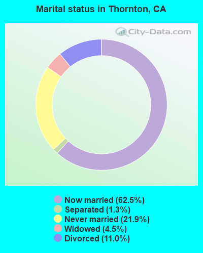
- Never married: 21.9%
- Now married: 62.5%
- Separated: 1.3%
- Widowed: 4.5%
- Divorced: 11.0%
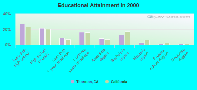
For population 25 years and over in Thornton:
- High school or higher: 72.8%
- Bachelor's degree or higher: 17.9%
- Graduate or professional degree: 5.1%
- Unemployed: 7.3%
- Mean travel time to work (commute): 28.3 minutes
| Here: | 17.3 |
| California average: | 16.1 |
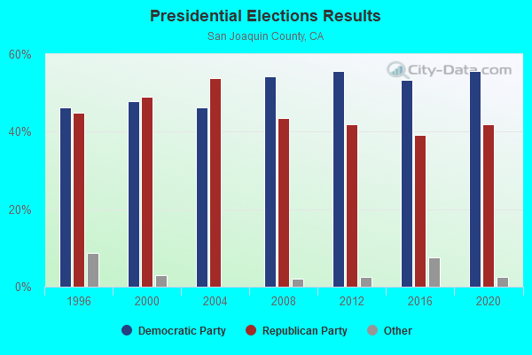
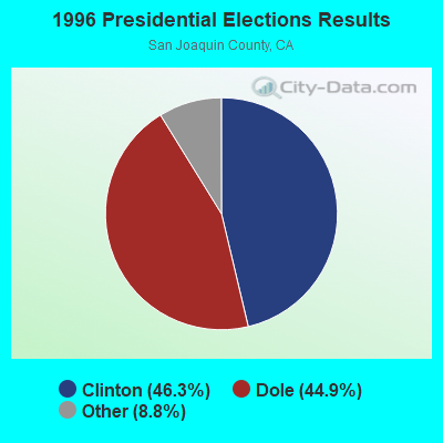
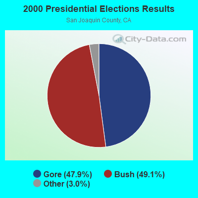
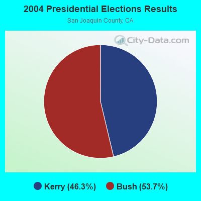
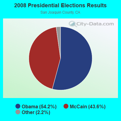
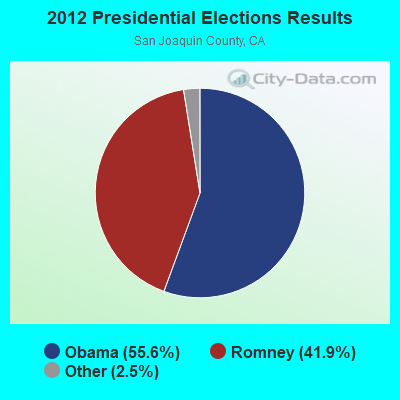
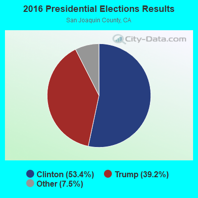

Graphs represent county-level data. Detailed 2008 Election Results
Religion statistics for Thornton, CA (based on San Joaquin County data)
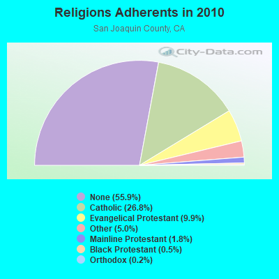
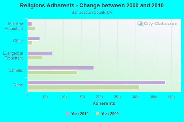
| Religion | Adherents | Congregations |
|---|---|---|
| Catholic | 183,692 | 18 |
| Evangelical Protestant | 67,940 | 304 |
| Other | 33,949 | 68 |
| Mainline Protestant | 12,067 | 43 |
| Black Protestant | 3,251 | 17 |
| Orthodox | 1,368 | 2 |
| None | 383,039 | - |
Food Environment Statistics:
| Here: | 2.34 / 10,000 pop. |
| California: | 2.14 / 10,000 pop. |
| San Joaquin County: | 0.04 / 10,000 pop. |
| California: | 0.04 / 10,000 pop. |
| This county: | 0.67 / 10,000 pop. |
| State: | 0.62 / 10,000 pop. |
| Here: | 2.02 / 10,000 pop. |
| State: | 1.49 / 10,000 pop. |
| San Joaquin County: | 5.23 / 10,000 pop. |
| State: | 7.42 / 10,000 pop. |
| Here: | 7.1% |
| California: | 7.3% |
| San Joaquin County: | 29.2% |
| State: | 21.3% |
| This county: | 16.5% |
| California: | 17.9% |
6.18% of this county's 2021 resident taxpayers lived in other counties in 2020 ($75,687 average adjusted gross income)
| Here: | 6.18% |
| California average: | 5.19% |
0.01% of residents moved from foreign countries ($71 average AGI)
San Joaquin County: 0.01% California average: 0.03%
Top counties from which taxpayers relocated into this county between 2020 and 2021:
| from Alameda County, CA | |
| from Santa Clara County, CA | |
| from Stanislaus County, CA |
5.64% of this county's 2020 resident taxpayers moved to other counties in 2021 ($66,959 average adjusted gross income)
| Here: | 5.64% |
| California average: | 6.14% |
0.01% of residents moved to foreign countries ($82 average AGI)
San Joaquin County: 0.01% California average: 0.02%
Top counties to which taxpayers relocated from this county between 2020 and 2021:
| to Stanislaus County, CA | |
| to Sacramento County, CA | |
| to Alameda County, CA |
Businesses in Thornton, CA
- Subway: 1
Strongest AM radio stations in Thornton:
- KHTK (1140 AM; 50 kW; SACRAMENTO, CA; Owner: INFINITY RADIO SUBSIDIARY OPERATIONS INC.)
- KSTE (650 AM; 25 kW; RANCHO CORDOVA, CA; Owner: AMFM RADIO LICENSES, L.L.C.)
- KCBC (770 AM; 50 kW; RIVERBANK, CA; Owner: KIERTRON, INC.)
- KTRB (860 AM; 50 kW; MODESTO, CA; Owner: PAPPAS RADIO OF CALIFORNIA, A CALIFORNIA LIMITED PARTNERSHIP)
- KCVR (1570 AM; 5 kW; LODI, CA; Owner: ENTRAVISION HOLDINGS, LLC)
- KATD (990 AM; 10 kW; PITTSBURG, CA; Owner: RADIO UNICA OF SACRAMENTO LICENSE CORP.)
- KNBR (680 AM; 50 kW; SAN FRANCISCO, CA; Owner: KNBR LICO, INC.)
- KGO (810 AM; 50 kW; SAN FRANCISCO, CA; Owner: KGO-AM RADIO, INC.)
- KCBS (740 AM; 50 kW; SAN FRANCISCO, CA; Owner: INFINITY BROADCASTING OPERATIONS, INC.)
- KTCT (1050 AM; 50 kW; SAN MATEO, CA; Owner: SUSQUEHANNA RADIO CORP.)
- KFAX (1100 AM; 50 kW; SAN FRANCISCO, CA; Owner: GOLDEN GATE BROADCASTING CO, INC.)
- KFIA (710 AM; 25 kW; CARMICHAEL, CA; Owner: VISTA BROADCASTING INC.)
- KFBK (1530 AM; 50 kW; SACRAMENTO, CA; Owner: AMFM RADIO LICENSES, L.L.C.)
Strongest FM radio stations in Thornton:
- KJOY (99.3 FM; STOCKTON, CA; Owner: CITADEL BROADCASTING COMPANY)
- KKSF-FM1 (103.7 FM; PLEASANTON, ETC., CA; Owner: AMFM RADIO LICENSES, L.L.C.)
- KBLX-FM2 (102.9 FM; PLEASANTON, CA; Owner: ICBC BROADCAST HOLDINGS -CA, INC.)
- KSOL-FM3 (98.9 FM; PLEASANTON, CA; Owner: TMS LICENSE CALIFORNIA, INC)
- KFRC-FM3 (99.7 FM; WALNUT CREEK, CA; Owner: INFINITY KFRC-FM, INC.)
- KZBR-FM1 (95.7 FM; WALNUT CREEK, CA; Owner: BONNEVILLE HOLDING COMPANY)
- KMEL-FM1 (106.1 FM; CONCORD, CA; Owner: AMFM RADIO LICENSES, L.L.C.)
- KISQ-FM3 (98.1 FM; CONCORD, CA; Owner: AMFM RADIO LICENSES, L.L.C.)
- KXJZ (88.9 FM; SACRAMENTO, CA; Owner: CALIFORNIA STATE UNIV., SACRAMENTO)
- KOSO (93.1 FM; PATTERSON, CA; Owner: CAPSTAR TX LIMITED PARTNERSHIP)
- K238AC (95.5 FM; SALIDA, CA; Owner: FAMILY STATIONS, INC.)
- KUIC (95.3 FM; VACAVILLE, CA; Owner: KUIC, INC.)
- KQOD (100.1 FM; STOCKTON, CA; Owner: CAPSTAR TX LIMITED PARTNERSHIP)
- KUOP (91.3 FM; STOCKTON, CA; Owner: UNIVERSITY OF THE PACIFIC)
- KEDR (88.1 FM; SACRAMENTO, CA; Owner: FAMILY STATIONS, INC.)
- KWIN (97.7 FM; LODI, CA; Owner: CITADEL BROADCASTING COMPANY)
- KZBR-FM2 (95.7 FM; LIVERMORE, ETC., CA; Owner: BONNEVILLE HOLDING COMPANY)
- KNDL (89.9 FM; ANGWIN, CA; Owner: HOWELL MOUNTAIN BROADCASTING COMPANY)
- KBAA (94.5 FM; GILROY, CA; Owner: INFINITY RADIO OPERATIONS INC.)
- KLVR (91.9 FM; SANTA ROSA, CA; Owner: EDUCATIONAL MEDIA FOUNDATION)
TV broadcast stations around Thornton:
- KUVS (Channel 19; MODESTO, CA; Owner: KUVS LICENSE PARTNERSHIP, G.P.)
- KOVR (Channel 13; STOCKTON, CA; Owner: SCI - SACRAMENTO LICENSEE, LLC)
- KXTV (Channel 10; SACRAMENTO, CA; Owner: KXTV, INC.)
- KCRA-TV (Channel 3; SACRAMENTO, CA; Owner: KCRA HEARST-ARGYLE TELEVISION, INC.)
- KQCA (Channel 58; STOCKTON, CA; Owner: KCRA HEARST-ARGYLE TELEVISION, INC.)
- KSPX (Channel 29; SACRAMENTO, CA; Owner: PAXSON SACRAMENTO LICENSE, INC.)
- KMAX-TV (Channel 31; SACRAMENTO, CA; Owner: UPN STATIONS GROUP INC.)
- KTXL (Channel 40; SACRAMENTO, CA; Owner: CHANNEL 40, INC.)
- KVIE (Channel 6; SACRAMENTO, CA; Owner: KVIE, INC.)
- KMMK-LP (Channel 14; SACRAMENTO, CA; Owner: CABALLERO TELEVISION TEXAS, L.L.C.)
- KDTS-CA (Channel 52; STOCKTON, CA; Owner: WORD OF GOD FELLOWSHIP, INC.)
- KEZT-CA (Channel 23; SACRAMENTO, CA; Owner: TELEFUTURA SACRAMENTO LLC)
- KMMW-LP (Channel 47; STOCKTON, CA; Owner: CABALLERO TELEVISION TEXAS, L.L.C.)
- KTNC-TV (Channel 42; CONCORD, CA; Owner: KTNC LICENSE, LLC)
- National Bridge Inventory (NBI) Statistics
- 3Number of bridges
- 23ft / 7.4mTotal length
- 54,840Total average daily traffic
- 12,527Total average daily truck traffic
FCC Registered Cell Phone Towers:
2 (See the full list of FCC Registered Cell Phone Towers in Thornton)FCC Registered Antenna Towers:
13 (See the full list of FCC Registered Antenna Towers)FCC Registered Broadcast Land Mobile Towers:
3- Fire House W Main St (Lat: 38.224917 Lon: -121.419944), Call Sign: KMG749,
Assigned Frequencies: 154.130 MHz, Grant Date: 02/17/2023, Expiration Date: 05/10/2033, Certifier: Dennis Bitters, Registrant: Ripon Fire Department, 142 S. Stockton Ave., Ripon, CA 95366, Phone: (209) 599-4209, Fax: (209) 599-2847, Email:
- Bensons Ferry Telemetry Sta (Lat: 38.255472 Lon: -121.439944), Type: Pole, Structure height: 5 m, Call Sign: KMY44,
Assigned Frequencies: 169.575 MHz, Grant Date: 06/27/2003, Expiration Date: 08/31/2013, Cancellation Date: 12/13/2011, Certifier: Glen S Nash, Registrant: State Of California, 601 Sequoia Pacific Blvd, Sacramento, CA 95811-0231, Phone: (916) 657-6153, Fax: (916) 657-9468, Email:
- Lat: 38.394361 Lon: -122.097750, Call Sign: WPWV596,
Assigned Frequencies: 151.865 MHz, 151.955 MHz, Grant Date: 02/05/2013, Expiration Date: 01/24/2023, Cancellation Date: 04/01/2023, Certifier: Sam Garamendi Mr., Registrant: Federal Licensing, Inc., 1588 Fairfield Road, Gettysburg, PA 17325, Phone: (717) 334-9262, Fax: (717) 334-6440
FCC Registered Microwave Towers:
7- THORNTON, 9899 W Barber Rd (Lat: 38.249056 Lon: -121.438000), Type: Mtower, Structure height: 38.4 m, Overall height: 39 m, Call Sign: WMR934,
Assigned Frequencies: 11245.0 MHz, 11245.0 MHz, 11245.0 MHz, 11245.0 MHz, 11405.0 MHz, 11405.0 MHz, 11405.0 MHz, 11405.0 MHz, Grant Date: 02/09/2021, Expiration Date: 02/01/2031, Registrant: Verizon Wireless, 5055 North Point Pkwy, Np2ne Network Engineering, Alpharetta, GA 30022, Phone: (770) 797-1070, Email:
- Cpf113 Mp 113.5 170 Ft Of Int Galt & Kile (Lat: 38.219056 Lon: -121.416889), Overall height: 18.3 m, Call Sign: WPNH886,
Assigned Frequencies: 941.700 MHz, Grant Date: 09/30/2022, Expiration Date: 10/23/2032, Cancellation Date: 05/05/2023, Registrant: Concentrix, 222 S 15th Street, 505n, Omaha, NE 68102, Phone: (402) 262-4785, Email:
- Cpf114 Mp 114.3 945 Ft N Of Int W Oak & Louisa St (Lat: 38.229056 Lon: -121.422444), Overall height: 18.3 m, Call Sign: WPNH887,
Assigned Frequencies: 941.700 MHz, Grant Date: 09/30/2022, Expiration Date: 10/23/2032, Cancellation Date: 05/05/2023, Registrant: Concentrix, 222 S 15th Street, 505n, Omaha, NE 68102, Phone: (402) 262-4785, Email:
- Cpf123 Mp 122.6 3192 Ft N Of Hein & Point Plesant Rd (Lat: 38.347111 Lon: -121.448833), Overall height: 18.3 m, Call Sign: WPNH889,
Assigned Frequencies: 941.700 MHz, Grant Date: 09/30/2022, Expiration Date: 10/23/2032, Cancellation Date: 05/05/2023, Registrant: Concentrix, 222 S 15th Street, 505n, Omaha, NE 68102, Phone: (402) 262-4785, Fax: (402) 233-2025, Email:
- Cpf121 Mp 121.3 3767 Ft S Of Hien & Point Pleasant Rd (Lat: 38.328222 Lon: -121.446333), Overall height: 18.3 m, Call Sign: WPNH890,
Assigned Frequencies: 941.700 MHz, Grant Date: 09/30/2022, Expiration Date: 10/23/2032, Cancellation Date: 05/05/2023, Registrant: Concentrix, 222 S 15th Street, 505n, Omaha, NE 68102, Phone: (402) 262-4785, Fax: (402) 233-2025, Email:
- THORNTON, 4.4 Mi North Of (Lat: 38.283222 Lon: -121.420500), Overall height: 48.8 m, Call Sign: WQP59,
Assigned Frequencies: 6197.20 MHz, 6226.90 MHz, 6315.90 MHz, 6345.50 MHz, 6375.20 MHz, 6404.80 MHz, Grant Date: 06/14/1993, Expiration Date: 02/01/2001, Cancellation Date: 03/17/1999, Registrant: Western Union Corporation, One Lake Street, Upper Saddle River, NJ 07458
- WALNUT GROVE, 11090 Barber Road (Lat: 38.245028 Lon: -121.455556), Type: Ltower, Structure height: 42.7 m, Overall height: 44.5 m, Call Sign: WRHX398,
Assigned Frequencies: 11465.0 MHz, 11505.0 MHz, 11545.0 MHz, 11625.0 MHz, 11505.0 MHz, 11545.0 MHz, 11585.0 MHz, 11625.0 MHz, Grant Date: 07/07/2020, Expiration Date: 07/07/2030, Certifier: Kevin Hetrick, Registrant: At&t Services, Inc., 208 S Akard St, 20f, Dallas, TX 75202, Phone: (855) 699-7073, Email:
FCC Registered Amateur Radio Licenses:
3- Call Sign: KA6BTG, Licensee ID: L01110907, Grant Date: 05/22/2017, Expiration Date: 05/22/2027, Certifier: Catherine A Green, Registrant: Catherine A Green, Thornton, CA 95686
- Call Sign: W1RAT, Previous Call Sign: KG6UTW, Licensee ID: L00853228, Grant Date: 06/10/2005, Expiration Date: 06/10/2015, Cancellation Date: 04/18/2006, Certifier: Richard L Freeman Jr, Registrant: Richard L Freeman Jr, Thornton, CA 95686
- Call Sign: AE6XP, Previous Call Sign: W1RAT, Licensee ID: L00853228, Grant Date: 06/10/2005, Expiration Date: 06/10/2015, Cancellation Date: 05/31/2006, Certifier: Richard L Freeman Jr, Registrant: Richard L Freeman Jr, Thornton, CA 95686
2004 - 2018 National Fire Incident Reporting System (NFIRS) incidents
- Fire incident types reported to NFIRS in Thornton, CA
- 33957.3%Outside Fires
- 17028.7%Mobile Property/Vehicle Fires
- 447.4%Structure Fires
- 396.6%Other
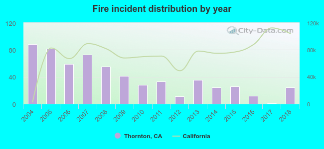 Based on the data from the years 2004 - 2018 the average number of fire incidents per year is 39. The highest number of reported fire incidents - 88 took place in 2004, and the least - 1 in 2017. The data has a declining trend.
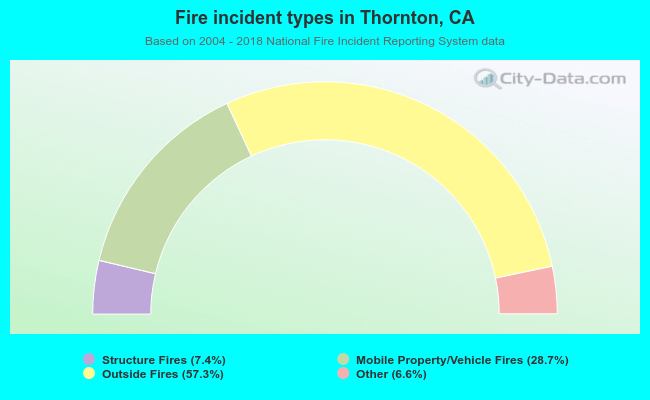 When looking into fire subcategories, the most incidents belonged to: Outside Fires (57.3%), and Mobile Property/Vehicle Fires (28.7%).
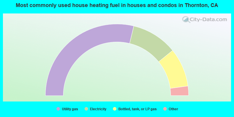
- 57.5%Utility gas
- 20.7%Electricity
- 17.4%Bottled, tank, or LP gas
- 3.0%Wood
- 0.8%Other fuel
- 0.6%Fuel oil, kerosene, etc.
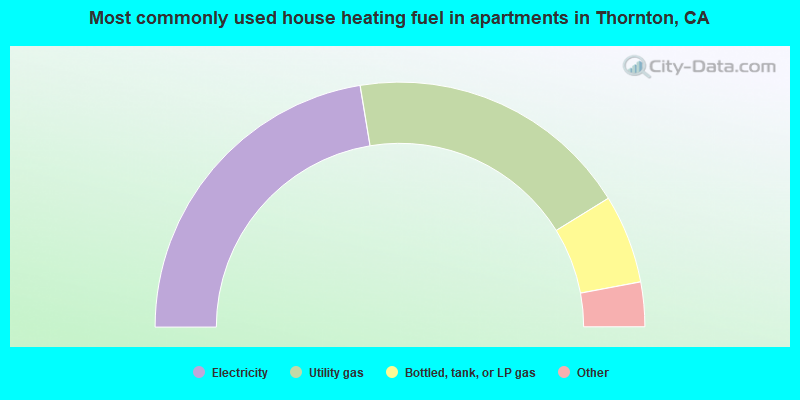
- 44.8%Electricity
- 37.6%Utility gas
- 11.7%Bottled, tank, or LP gas
- 4.0%Fuel oil, kerosene, etc.
- 1.9%Wood
Thornton compared to California state average:
- Unemployed percentage below state average.
- Foreign-born population percentage significantly below state average.
- Renting percentage below state average.
- Length of stay since moving in significantly above state average.
- Number of rooms per house significantly below state average.
- House age significantly below state average.
Thornton on our top lists:
- #2 on the list of "Top 101 cities with largest percentage of females in occupations: counselors, social workers, and other community and social service specialists (population 5,000+)"
- #6 on the list of "Top 101 cities with largest percentage of males in occupations: agricultural workers including supervisors (population 5,000+)"
- #6 on the list of "Top 101 cities with largest percentage of females in industries: music stores (population 5,000+)"
- #8 on the list of "Top 101 cities with largest percentage of males in occupations: counselors, social workers, and other community and social service specialists (population 5,000+)"
- #12 on the list of "Top 101 cities with largest percentage of females in industries: building material and garden equipment and supplies dealers (population 5,000+)"
- #15 on the list of "Top 101 cities with largest percentage of females in occupations: other health diagnosing and treating practitioners and technical occupations (population 5,000+)"
- #16 on the list of "Top 101 cities with largest percentage of females in industries: sewing, needlework, and piece goods stores (population 5,000+)"
- #18 on the list of "Top 101 cities with largest percentage of males in occupations: other transportation workers (population 5,000+)"
- #23 on the list of "Top 101 cities with largest percentage of females in occupations: agricultural workers including supervisors (population 5,000+)"
- #27 on the list of "Top 101 cities with largest percentage of females in industries: other direct selling establishments (population 5,000+)"
- #34 on the list of "Top 101 cities with largest percentage of females in industries: drugs, sundries, and chemical and allied products merchant wholesalers (population 5,000+)"
- #55 on the list of "Top 101 cities with largest percentage of females in industries: food (population 5,000+)"
- #55 on the list of "Top 101 cities with largest percentage of females in industries: petroleum and petroleum products merchant wholesalers (population 5,000+)"
- #61 on the list of "Top 101 cities with largest percentage of males in industries: motor vehicles, parts and supplies merchant wholesalers (population 5,000+)"
- #66 on the list of "Top 101 cities with largest percentage of males in industries: agriculture, forestry, fishing and hunting (population 5,000+)"
- #76 on the list of "Top 101 cities with largest percentage of males in industries: motor vehicle and parts dealers (population 5,000+)"
- #81 on the list of "Top 101 cities with largest percentage of males in industries: beverage and tobacco products (population 5,000+)"
- #87 on the list of "Top 101 cities with the largest percentage of people in agriculture workers' dormitories on farms (population 1,000+)"
- #89 on the list of "Top 101 cities with largest percentage of males in industries: food (population 5,000+)"
- #95 on the list of "Top 101 cities with largest percentage of females in industries: gasoline stations (population 5,000+)"
- #12 on the list of "Top 101 counties with the highest lead air pollution readings in 2012 (µg/m3)"
- #16 on the list of "Top 101 counties with the lowest lead air pollution readings in 2012 (µg/m3)"
- #31 on the list of "Top 101 counties with the highest Particulate Matter (PM2.5) Annual air pollution readings in 2012 (µg/m3)"
- #38 on the list of "Top 101 counties with the highest ground withdrawal of fresh water for public supply"
- #46 on the list of "Top 101 counties with the lowest Ozone (1-hour) air pollution readings in 2012 (ppm)"