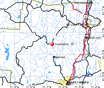
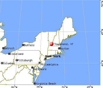
Townshend, Vermont
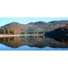
Townshend: Townshend
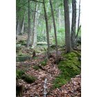
Townshend: West River Trail
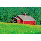
Townshend: Barn on East Hill Road in Spring
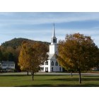
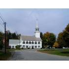
Townshend: Townshend Church in the Fall

Townshend: Crane Mountain Walk Fall 2008
Townshend: Townshend Dam in Fall
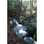
Townshend: Backwood Trail
- add
your
Submit your own pictures of this town and show them to the world
- OSM Map
- General Map
- Google Map
- MSN Map
Population change since 2000: +7.2%
 |
| Males: 606 | |
| Females: 626 |
| Median resident age: | 47.8 years |
| Vermont median age: | 45.8 years |
Zip codes: 05353.
| Townshend: | $67,306 |
| VT: | $73,991 |
Estimated per capita income in 2022: $38,644 (it was $19,431 in 2000)
Townshend town income, earnings, and wages data
Estimated median house or condo value in 2022: $299,547 (it was $120,400 in 2000)
| Townshend: | $299,547 |
| VT: | $304,700 |
Mean prices in 2022: all housing units: $298,935; detached houses: $317,292; townhouses or other attached units: $299,018; in 2-unit structures: $292,940; in 3-to-4-unit structures: $427,770; in 5-or-more-unit structures: $214,034; mobile homes: $65,502
Detailed information about poverty and poor residents in Townshend, VT


- 1,17795.5%White alone
- 252.0%Hispanic
- 141.1%Two or more races
- 80.6%Asian alone
- 60.5%Black alone
- 10.08%American Indian alone
- 10.08%Other race alone

Races in Townshend detailed stats: ancestries, foreign born residents, place of birth
 Recent articles from our blog. Our writers, many of them Ph.D. graduates or candidates, create easy-to-read articles on a wide variety of topics.

 | Official Vermont Picture Thread (966 replies) |
| Vermont, are you right for me? (11 replies) |
| Southern Vermont Campgrounds near Brattlboro? (11 replies) |
| Vermont, guns and politics?? (30 replies) |
| Photos: Townshend VT tavern & barn featured in movie Funny Farm (0 replies) |
| Moving to Vermont- nice areas between Brattleboro and Springfield (10 replies) |
Latest news from Townshend, VT collected exclusively by city-data.com from local newspapers, TV, and radio stations
Ancestries: English (21.2%), Irish (16.3%), German (13.4%), United States (8.7%), French (7.7%), Scottish (5.0%).
Current Local Time: EST time zone
Incorporated in 1916
Elevation: 574 feet
Land area: 42.7 square miles.
Population density: 29 people per square mile (very low).
24 residents are foreign born (1.4% Europe, 0.3% Asia, 0.3% North America).
| This town: | 2.1% |
| Vermont: | 3.8% |
| Townshend town: | 2.2% ($2,637) |
| Vermont: | 2.0% ($2,196) |
Nearest city with pop. 50,000+: Chicopee, MA  (60.9 miles , pop. 54,653).
Nearest city with pop. 200,000+: Boston, MA (95.4 miles , pop. 589,141).
Nearest city with pop. 1,000,000+: Bronx, NY (164.0 miles , pop. 1,332,650).
Nearest cities:
), ), ), Latitude: 43.05 N, Longitude: 72.68 W
Area code commonly used in this area: 802


| Here: | 2.3% |
| Vermont: | 2.0% |


- Construction (12.8%)
- Health care (11.0%)
- Educational services (9.6%)
- Accommodation & food services (7.5%)
- Professional, scientific, technical services (7.0%)
- Finance & insurance (4.7%)
- Miscellaneous manufacturing (3.1%)

- Construction (24.3%)
- Educational services (6.5%)
- Professional, scientific, technical services (4.8%)
- Accommodation & food services (4.5%)
- Other transportation, support activities, couriers (4.1%)
- Agriculture, forestry, fishing & hunting (3.8%)
- Miscellaneous manufacturing (3.4%)

- Health care (18.9%)
- Educational services (12.9%)
- Accommodation & food services (10.7%)
- Professional, scientific, technical services (9.3%)
- Finance & insurance (7.1%)
- Food & beverage stores (5.0%)
- Public administration (3.6%)

- Carpenters (5.4%)
- Other sales and related occupations, including supervisors (5.2%)
- Other management occupations, except farmers and farm managers (4.7%)
- Other production occupations, including supervisors (4.4%)
- Preschool, kindergarten, elementary, and middle school teachers (3.8%)
- Driver/sales workers and truck drivers (3.1%)
- Sales representatives, services, wholesale and manufacturing (3.0%)

- Carpenters (10.6%)
- Other production occupations, including supervisors (6.8%)
- Driver/sales workers and truck drivers (6.2%)
- Electrical equipment mechanics and other installation, maintenance, and repair workers, including supervisors (5.1%)
- Material recording, scheduling, dispatching, and distributing workers (4.1%)
- Lawyers (4.1%)
- Vehicle and mobile equipment mechanics, installers, and repairers (4.1%)

- Preschool, kindergarten, elementary, and middle school teachers (7.1%)
- Other sales and related occupations, including supervisors (6.8%)
- Other management occupations, except farmers and farm managers (6.1%)
- Information and record clerks, except customer service representatives (6.1%)
- Financial clerks, except bookkeeping, accounting and auditing clerks (5.0%)
- Building and grounds cleaning and maintenance occupations (4.6%)
- Secretaries and administrative assistants (3.9%)
Average climate in Townshend, Vermont
Based on data reported by over 4,000 weather stations


(lower is better)

Air Quality Index (AQI) level in 2022 was 59.0. This is better than average.
| City: | 59.0 |
| U.S.: | 72.6 |


Sulfur Dioxide (SO2) [ppb] level in 2003 was 3.66. This is significantly worse than average. Closest monitor was 20.1 miles away from the city center.
| City: | 3.66 |
| U.S.: | 1.51 |

Ozone [ppb] level in 2022 was 23.7. This is significantly better than average. Closest monitor was 14.0 miles away from the city center.
| City: | 23.7 |
| U.S.: | 33.3 |

Particulate Matter (PM2.5) [µg/m3] level in 2022 was 5.97. This is better than average. Closest monitor was 22.3 miles away from the city center.
| City: | 5.97 |
| U.S.: | 8.11 |
Tornado activity:
Townshend-area historical tornado activity is significantly above Vermont state average. It is 36% smaller than the overall U.S. average.
On 8/20/1968, a category F3 (max. wind speeds 158-206 mph) tornado 6.9 miles away from the Townshend town center injured one person and caused between $5000 and $50,000 in damages.
On 5/31/1998, a category F3 tornado 26.4 miles away from the town center injured 68 people and caused $71 million in damages.
Earthquake activity:
Townshend-area historical earthquake activity is significantly above Vermont state average. It is 69% smaller than the overall U.S. average.On 10/7/1983 at 10:18:46, a magnitude 5.3 (5.1 MB, 5.3 LG, 5.1 ML, Class: Moderate, Intensity: VI - VII) earthquake occurred 104.1 miles away from the city center
On 4/20/2002 at 10:50:47, a magnitude 5.3 (5.3 ML, Depth: 3.0 mi) earthquake occurred 113.3 miles away from the city center
On 4/20/2002 at 10:50:47, a magnitude 5.2 (5.2 MB, 4.2 MS, 5.2 MW, 5.0 MW) earthquake occurred 112.2 miles away from Townshend center
On 1/19/1982 at 00:14:42, a magnitude 4.7 (4.5 MB, 4.7 MD, 4.5 LG, Class: Light, Intensity: IV - V) earthquake occurred 62.9 miles away from the city center
On 10/16/2012 at 23:12:25, a magnitude 4.7 (4.7 ML, Depth: 10.0 mi) earthquake occurred 108.9 miles away from Townshend center
On 6/17/1991 at 08:53:16, a magnitude 4.1 (4.0 MB, 4.0 LG, Depth: 3.1 mi) earthquake occurred 105.2 miles away from the city center
Magnitude types: regional Lg-wave magnitude (LG), body-wave magnitude (MB), duration magnitude (MD), local magnitude (ML), surface-wave magnitude (MS), moment magnitude (MW)
Natural disasters:
The number of natural disasters in Windham County (16) is near the US average (15).Major Disasters (Presidential) Declared: 13
Emergencies Declared: 2
Causes of natural disasters: Floods: 11, Storms: 10, Tropical Storms: 2, Hurricane: 1, Landslide: 1, Snowstorm: 1, Wind: 1, Winter Storm: 1 (Note: some incidents may be assigned to more than one category).

Hospitals and medical centers in Townshend:
- GRACE COTTAGE HOSPITAL (Voluntary non-profit - Private, provides emergency services, PO BOX 216)
- STRATTON HOUSE NURSING HOME (ROUTE 35)
Other hospitals and medical centers near Townshend:
- CHESHIRE COUNTY HOME (Nursing Home, about 13 miles away; WESTMORELAND, NH)
- MCGIRR NURSING HOME (Nursing Home, about 14 miles away; BELLOWS FALLS, VT)
- LINDEN LODGE NURSING HOME (Nursing Home, about 15 miles away; BRATTLEBORO, VT)
- SOUTHERN VERMONT HOME HEALTH (Home Health Center, about 16 miles away; BRATTLEBORO, VT)
- THOMPSON HOUSE NURSING HOME (Nursing Home, about 16 miles away; BRATTLEBORO, VT)
- BRATTLEBORO MEMORIAL HOSPITAL Acute Care Hospitals (about 16 miles away; BRATTLEBORO, VT)
- PINE HEIGHTS AT BRATTLEBORO CENTER FOR NURSING AND R (Nursing Home, about 16 miles away; BRATTLEBORO, VT)
Airports located in Townshend:
- Onyon Airport (VT43) (Runways: 2)
Amtrak stations near Townshend:
- 14 miles: BELLOWS FALLS (DEPOT ST.) . Services: enclosed waiting area, public restrooms, public payphones, free short-term parking, free long-term parking, call for taxi service.
- 16 miles: BRATTLEBORO (VERNON RD.) . Services: enclosed waiting area, public restrooms, call for car rental service, call for taxi service.
Colleges/universities with over 2000 students nearest to Townshend:
- Keene State College (about 23 miles; Keene, NH; Full-time enrollment: 5,098)
- Williams College (about 36 miles; Williamstown, MA; FT enrollment: 2,141)
- Franklin Pierce University (about 37 miles; Rindge, NH; FT enrollment: 2,139)
- Castleton State College (about 47 miles; Castleton, VT; FT enrollment: 2,079)
- University of Massachusetts-Amherst (about 47 miles; Amherst, MA; FT enrollment: 26,583)
- Mount Wachusett Community College (about 48 miles; Gardner, MA; FT enrollment: 3,143)
- Dartmouth College (about 50 miles; Hanover, NH; FT enrollment: 6,030)
Public high school in Townshend:
- LELAND & GRAY UHSD #34 (Students: 395, Location: 2042 VT ROUTE 30, Grades: 7-12)
Public elementary/middle school in Townshend:
- TOWNSHEND VILLAGE SCHOOL (Students: 82, Location: 66 COMMON ROAD - ROUTE 30, Grades: PK-6)
Points of interest:
Notable locations in Townshend: Bald Mountain Campground (A), Townshend Dam (B), Camperama Family Campground (C), Townshend Volunteer Fire Department (D), Rescue Incorporated Division 2 (E). Display/hide their locations on the map
Church in Townshend: Calvary Chapel (A). Display/hide its location on the map
Cemeteries: Twitchell Cemetery (1), Sanderson Burial Plot (2), Round Hill Cemetery (3), Oakwood Cemetery (4), Maple Grove Cemetery (5), Holland-Brigham-Bixby Cemetery (6), Fisher Cemetery (7). Display/hide their locations on the map
Reservoir: Townshend Reservoir (A). Display/hide its location on the map
Streams, rivers, and creeks: Tannery Brook (A), Stiles Brook (B), Simpson Brook (C), Ranney Brook (D), Mill Brook (E), Fair Brook (F), Acton Brook (G), Negro Brook (H). Display/hide their locations on the map
Parks in Townshend include: West Townshend Village Historic District (1), Townshend Dam Recreation Area (2). Display/hide their locations on the map
Birthplace of: Alphonso Taft - Diplomat, Marshall H. Twitchell - Politician, Clarina I. H. Nichols - Journalist.
Drinking water stations with addresses in Townshend and their reported violations in the past:
BALD MOUNTAIN CAMPGROUND (Address: 1760 STATE FOREST RD , Population served: 784, Groundwater):Past health violations:LELAND GRAY USD 34 (Population served: 460, Groundwater):Past monitoring violations:
- MCL, Monthly (TCR) - In JUL-2013, Contaminant: Coliform. Follow-up actions: St Public Notif requested (AUG-13-2013), St Formal NOV issued (AUG-13-2013), St Public Notif received (AUG-26-2013)
- MCL, Monthly (TCR) - Between JUL-2006 and SEP-2006, Contaminant: Coliform. Follow-up actions: St Formal NOV issued (JUL-21-2006), St Boil Water Order (JUL-21-2006), St Tech Assistance Visit (JUL-21-2006), St Public Notif requested (JUL-21-2006), St Compliance achieved (JAN-29-2010)
- One routine major monitoring violation
- One minor monitoring violation
- One regular monitoring violation
Past health violations:MTN VIEW SEVENTH DAY ADVENTIST CHURCH (Address: 254 DEPOT RD , Population served: 269, Groundwater):Past monitoring violations:
- MCL, Monthly (TCR) - In SEP-2007, Contaminant: Coliform. Follow-up actions: St Public Notif received (SEP-02-2007), St Public Notif requested (SEP-17-2007), St Formal NOV issued (SEP-17-2007), St Compliance achieved (SEP-25-2009)
- MCL, Monthly (TCR) - In AUG-2007, Contaminant: Coliform. Follow-up actions: St Boil Water Order (AUG-17-2007), St Formal NOV issued (AUG-17-2007), St Tech Assistance Visit (AUG-17-2007), St Public Notif requested (AUG-17-2007), St Public Notif received (SEP-07-2007), St Compliance achieved (SEP-25-2009)
- Monitoring, Repeat Major (TCR) - Between JUL-2007 and SEP-2007, Contaminant: Coliform (TCR). Follow-up actions: St Formal NOV issued (OCT-24-2007), St Public Notif requested (OCT-24-2007), St Public Notif received (NOV-15-2007), St Compliance achieved (SEP-25-2009)
- 3 routine major monitoring violations
Past health violations:CARLOS OTIS HEALTH CARE CENTER (Address: 185 GRAFTON RD RT 35 , Population served: 254, Groundwater):Past monitoring violations:
- MCL, Monthly (TCR) - In JUL-2009, Contaminant: Coliform. Follow-up actions: St Public Notif requested (JUL-09-2009), St Formal NOV issued (JUL-09-2009), St Compliance achieved (AUG-09-2010)
- One regular monitoring violation
Past monitoring violations:TOWNSHEND ELEMENTARY SCHOOL (Population served: 105, Groundwater):
- Monitoring and Reporting (DBP) - Between JAN-2005 and DEC-2005, Contaminant: TTHM. Follow-up actions: St Public Notif requested (JUN-26-2006), St Formal NOV issued (JUN-26-2006), St Public Notif received (JUL-13-2006), St Compliance achieved (MAR-16-2011)
- 21 regular monitoring violations
Past health violations:WEST RIVER VALLEY SENIOR HOUSING (Population served: 92, Groundwater):Past monitoring violations:
- MCL, Monthly (TCR) - In OCT-2006, Contaminant: Coliform. Follow-up actions: St Tech Assistance Visit (NOV-03-2006), St Boil Water Order (NOV-03-2006), St Public Notif requested (NOV-03-2006), St Formal NOV issued (NOV-03-2006), St Compliance achieved (DEC-28-2006)
- MCL, Monthly (TCR) - In SEP-2006, Contaminant: Coliform. Follow-up actions: St Tech Assistance Visit (SEP-29-2006), St Boil Water Order (SEP-29-2006), St Public Notif requested (SEP-29-2006), St Formal NOV issued (SEP-29-2006), St Compliance achieved (DEC-28-2006)
- One regular monitoring violation
Past health violations:TOWNSHEND DAM DINER (Population served: 59, Groundwater):Past monitoring violations:
- MCL, Monthly (TCR) - In SEP-2013, Contaminant: Coliform. Follow-up actions: St Tech Assistance Visit (SEP-13-2013), St Formal NOV issued (SEP-13-2013), St Public Notif requested (SEP-13-2013), St Public Notif received (SEP-13-2013), St Boil Water Order (SEP-13-2013), St Compliance achieved (SEP-20-2013)
- MCL, Monthly (TCR) - In AUG-2012, Contaminant: Coliform. Follow-up actions: St Tech Assistance Visit (AUG-22-2012), St Formal NOV issued (AUG-22-2012), St Boil Water Order (AUG-22-2012), St Public Notif requested (AUG-22-2012), St Public Notif received (AUG-31-2012), St Compliance achieved (AUG-31-2012)
- Follow-up Or Routine LCR Tap M/R - In OCT-01-2013, Contaminant: Lead and Copper Rule. Follow-up actions: St Formal NOV issued (NOV-26-2013), St Tech Assistance Visit (NOV-26-2013), St Public Notif requested (NOV-26-2013), St Public Notif received (JUN-06-2014)
- Monitoring, Repeat Major (TCR) - In OCT-2010, Contaminant: Coliform (TCR). Follow-up actions: St Public Notif requested (NOV-24-2010), St Formal NOV issued (NOV-24-2010), St Public Notif received (JUN-29-2011), St Compliance achieved (FEB-08-2012)
- 2 routine major monitoring violations
- 2 minor monitoring violations
Past monitoring violations:MARY MEYER CORP (Population served: 52, Groundwater):
- 21 routine major monitoring violations
- 7 regular monitoring violations
Past monitoring violations:
- Follow-up Or Routine LCR Tap M/R - In JAN-01-1999, Contaminant: Lead and Copper Rule
- Follow-up Or Routine LCR Tap M/R - In JAN-01-1998, Contaminant: Lead and Copper Rule. Follow-up actions: St Public Notif requested (JUL-01-1998), St Violation/Reminder Notice (JUL-01-1998), St Compliance achieved (APR-26-2011)
- Follow-up Or Routine LCR Tap M/R - In JAN-01-1997, Contaminant: Lead and Copper Rule. Follow-up actions: St Violation/Reminder Notice (JUL-01-1997), St Compliance achieved (APR-26-2011)
- 3 routine major monitoring violations
- 36 regular monitoring violations
Drinking water stations with addresses in Townshend that have no violations reported:
| This town: | 2.1 people |
| Vermont: | 2.3 people |
| This town: | 56.6% |
| Whole state: | 62.5% |
| This town: | 8.4% |
| Whole state: | 9.2% |
Likely homosexual households (counted as self-reported same-sex unmarried-partner households)
- Lesbian couples: 0.7% of all households
- Gay men: 0.2% of all households
| This town: | 8.8% |
| Whole state: | 9.4% |
| This town: | 3.8% |
| Whole state: | 3.6% |
For population 15 years and over in Townshend:

- Never married: 21.3%
- Now married: 57.2%
- Separated: 1.0%
- Widowed: 9.4%
- Divorced: 11.1%
For population 25 years and over in Townshend:
- High school or higher: 87.6%
- Bachelor's degree or higher: 25.0%
- Graduate or professional degree: 10.9%
- Unemployed: 2.9%
- Mean travel time to work (commute): 23.7 minutes


| Here: | 10.1 |
| Vermont average: | 11.7 |
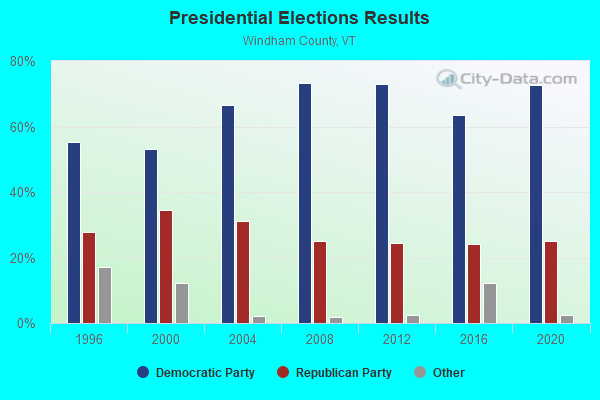
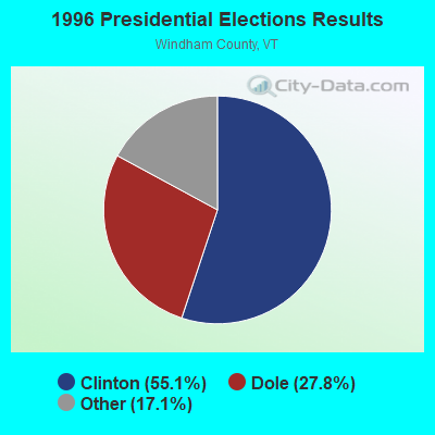
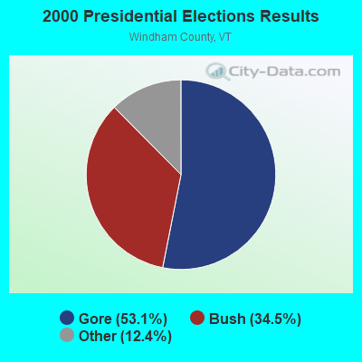
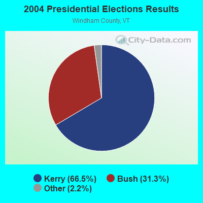
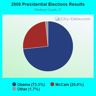

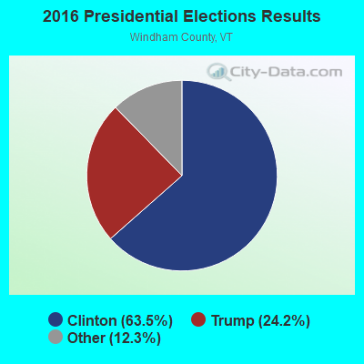
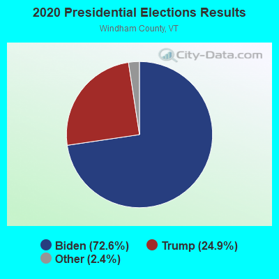
Graphs represent county-level data. Detailed 2008 Election Results
Religion statistics for Townshend, VT (based on Windham County data)
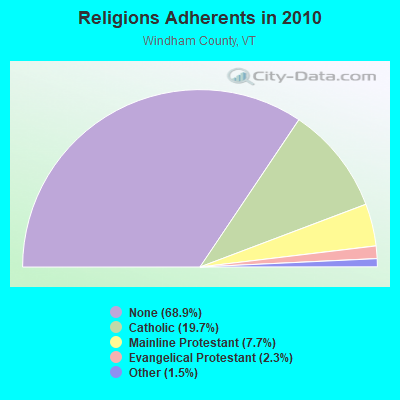
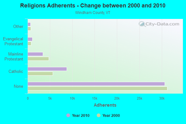
| Religion | Adherents | Congregations |
|---|---|---|
| Catholic | 8,753 | 8 |
| Mainline Protestant | 3,412 | 38 |
| Evangelical Protestant | 1,026 | 13 |
| Other | 647 | 12 |
| None | 30,675 | - |
Food Environment Statistics:
| Windham County: | 4.14 / 10,000 pop. |
| Vermont: | 3.84 / 10,000 pop. |
| Here: | 1.38 / 10,000 pop. |
| Vermont: | 1.95 / 10,000 pop. |
| Windham County: | 7.37 / 10,000 pop. |
| Vermont: | 6.40 / 10,000 pop. |
| Windham County: | 18.87 / 10,000 pop. |
| Vermont: | 11.52 / 10,000 pop. |
| Windham County: | 6.7% |
| Vermont: | 6.8% |
| Windham County: | 22.6% |
| State: | 22.3% |
| Here: | 12.5% |
| State: | 13.3% |
Businesses in Townshend, VT
- FedEx: 1
Strongest AM radio stations in Townshend:
- WNNZ (640 AM; 50 kW; WESTFIELD, MA; Owner: CLEAR CHANNEL BROADCASTING LICENSES, INC.)
- WCRN (830 AM; 50 kW; WORCESTER, MA; Owner: CARTER BROADCASTING CORPORATION)
- WGY (810 AM; 50 kW; SCHENECTADY, NY; Owner: CLEAR CHANNEL BROADCASTING LICENSES, INC.)
- WRKO (680 AM; 50 kW; BOSTON, MA; Owner: ENTERCOM BOSTON LICENSE, LLC)
- WNBX (1480 AM; 5 kW; SPRINGFIELD, VT)
- WKBK (1290 AM; 5 kW; KEENE, NH; Owner: SAGA COMMUNICATIONS OF NEW ENGLAND, LLC)
- WNTK (1020 AM; 10 kW; NEWPORT, NH; Owner: KOOR COMMUNICATIONS, INC.)
- WPTR (1540 AM; 50 kW; ALBANY, NY; Owner: KIMTRON, INC.)
- WVNE (760 AM; daytime; 25 kW; LEICESTER, MA; Owner: BLOUNT MASSCOM, INC.)
- WEEI (850 AM; 50 kW; BOSTON, MA; Owner: ENTERCOM BOSTON LICENSE, LLC)
- WIZZ (1520 AM; daytime; 10 kW; GREENFIELD, MA; Owner: P. & M. RADIO, LLC)
- WKOX (1200 AM; 50 kW; FRAMINGHAM, MA; Owner: CAPSTAR TX LIMITED PARTNERSHIP)
- WTIC (1080 AM; 50 kW; HARTFORD, CT; Owner: INFINITY RADIO OPERATIONS INC.)
Strongest FM radio stations in Townshend:
- WCMK (91.9 FM; PUTNEY, VT; Owner: CHRISTIAN MINISTRIES INC)
- WVAY (100.7 FM; WILMINGTON, VT; Owner: GREAT NORTHERN RADIO, L.L.C.)
- WEQX (102.7 FM; MANCHESTER, VT; Owner: NORTHSHIRE COMMUNICATIONS, INC.)
- WJAN (95.1 FM; SUNDERLAND, VT; Owner: 6 JOHNSON ROAD LICENSES, INC.)
- WCFR-FM (96.3 FM; WALPOLE, NH; Owner: GREAT NORTHERN RADIO, LLC)
- WKVT-FM (92.7 FM; BRATTLEBORO, VT; Owner: SAGA COMMUNICATIONS OF NEW ENGLAND, LLC)
- WKNE (103.7 FM; KEENE, NH; Owner: SAGA COMMUNICATIONS OF NEW ENGLAND, LLC)
- WVPR (89.5 FM; WINDSOR, VT; Owner: VERMONT PUBLIC RADIO)
- WEVN (90.7 FM; KEENE, NH; Owner: NEW HAMPSHIRE PUBLIC RADIO, INC.)
- WHDQ (106.1 FM; CLAREMONT, NH; Owner: GREAT NORTHERN RADIO, L.L.C.)
- WRSY (101.5 FM; MARLBORO, VT; Owner: GREAT NORTHERN RADIO, L.L.C.)
- WJJR (98.1 FM; RUTLAND, VT; Owner: 6 JOHNSON ROAD LICENSES, INC.)
- WZRT (97.1 FM; RUTLAND, VT; Owner: CAPSTAR TX LIMITED PARTNERSHIP)
- WEBK (105.3 FM; KILLINGTON, VT; Owner: 6 JOHNSON ROAD LICENSES, INC.)
- WGLV (91.7 FM; WOODSTOCK, VT; Owner: CHRISTIAN MINISTRIES INC)
- WAMC-FM (90.3 FM; ALBANY, NY; Owner: WAMC)
- WHDQ-FM1 (106.1 FM; RUTLAND, VT; Owner: GREAT NORTHERN RADIO, L.L.C.)
- WVRR (101.7 FM; NEWPORT, NH; Owner: CAPSTAR TX LIMITED PARTNERSHIP)
- WPVQ (95.3 FM; GREENFIELD, MA; Owner: GREAT NORTHERN RADIO, L.L.C.)
- WYRY (104.9 FM; HINSDALE, NH; Owner: TRI-VALLEY BROADCASTING CORPORATION)
TV broadcast stations around Townshend:
- WEKW-TV (Channel 52; KEENE, NH; Owner: UNIVERSITY OF NEW HAMPSHIRE)
- Townshend, Vermont
- Fatal accident count10
- Vehicles involved in fatal accidents13
- Fatal accidents involving drunk persons:5
- Fatalities14
- Persons involved in fatal accidents26
- Pedestrians involved in fatal accidents0
- Vermont average
- Fatal accident count949
- Vehicles involved in fatal accidents1288
- Fatal accidents involving drunk persons401
- Fatalities1089
- Persons involved in fatal accidents2377
- Pedestrians involved in fatal accidents23
- National Bridge Inventory (NBI) Statistics
- 10Number of bridges
- 89ft / 27.0mTotal length
- $7,207,000Total costs
- 9,840Total average daily traffic
- 381Total average daily truck traffic
- 10,334Total future (year 2028) average daily traffic

- New bridges - historical statistics
- 71930-1939
- 11950-1959
- 11980-1989
- 12000-2009
FCC Registered Antenna Towers:
11 (See the full list of FCC Registered Antenna Towers in Townshend)FCC Registered Private Land Mobile Towers:
1- 185 Grafton Road (Lat: 43.049000 Lon: -72.668194), Type: Bant, Structure height: 9.1 m, Overall height: 10.1 m, Call Sign: WPNW677,
Assigned Frequencies: 157.740 MHz, Grant Date: 06/25/2019, Expiration Date: 07/19/2029, Certifier: Signature On File, Registrant: Cara Enterprises, Inc, Las Vegas, NV 89140-0124, Phone: (702) 838-9728, Fax: (702) 363-4607, Email:
FCC Registered Broadcast Land Mobile Towers:
4- Fire Station Rt 35 (Lat: 43.050083 Lon: -72.666194), Call Sign: KFR667,
Assigned Frequencies: 154.430 MHz, Grant Date: 04/29/2014, Expiration Date: 06/21/2024, Registrant: Town Of Townshend, 2006 Vermont Rt 30, Townshend, VT 05353-0223, Phone: (802) 365-7300
- Summit Of Cran Mountain Plum Rd (Lat: 43.045361 Lon: -72.632028), Type: Tower, Structure height: 30 m, Call Sign: WPPB580,
Assigned Frequencies: 48.6400 MHz, 47.8000 MHz, 48.0000 MHz, Grant Date: 09/18/2014, Expiration Date: 10/14/2023, Cancellation Date: 12/16/2023, Certifier: Noel Christie, Registrant: Green Mountain Power Corp, 2152 Post Rd, Rutland, VT 05701, Phone: (802) 770-3210, Fax: (802) 770-3499, Email:
- Summit Of Crane Mtn (Lat: 43.045361 Lon: -72.632028), Type: Tower, Structure height: 33 m, Overall height: 36 m, Call Sign: WQHI788,
Assigned Frequencies: 173.262 MHz, Grant Date: 08/08/2007, Expiration Date: 08/08/2017, Cancellation Date: 07/27/2017, Certifier: Noel Christie, Registrant: Green Mountain Power Corp, 2152 Post Rd, Rutland, VT 05701, Phone: (802) 770-3210, Fax: (802) 770-3499, Email:
- Grace Cottage HEAR, 185 Grafton Road (Lat: 43.048889 Lon: -72.667500), Type: Bant, Structure height: 10 m, Overall height: 15 m, Call Sign: WQQY552,
Assigned Frequencies: 155.280 MHz, 155.340 MHz, Grant Date: 02/28/2023, Expiration Date: 03/26/2033, Certifier: Tony Marques, Registrant: Business Radio Licensing, 30251 Golden Lantern, Suite E # 501, Laguna Niguel, CA 92677, Phone: (949) 348-8510, Fax: (949) 348-8514, Email:
FCC Registered Microwave Towers:
5- CRANE MT, Townshend Acres Plum Rd 5 Mi Off Rt 30 (Lat: 43.045528 Lon: -72.631111), Type: Ltower, Structure height: 33.2 m, Overall height: 39.6 m, Call Sign: WNTK891,
Assigned Frequencies: 11485.0 MHz, 11485.0 MHz, 11485.0 MHz, 6093.45 MHz, 11485.0 MHz, 6152.75 MHz, Grant Date: 01/22/2013, Expiration Date: 10/06/2022, Cancellation Date: 12/10/2022, Certifier: Phillip T Chitwood, Registrant: Vermont Transco, 366 Pinnacle Eidge Road, Rutland, VT 05701, Phone: (802) 772-3777, Email:
- CRANE MOUNTAIN, 1069 Hazel Hill Road (Lat: 43.045528 Lon: -72.631111), Type: Tower, Structure height: 21.3 m, Call Sign: WQNM281,
Assigned Frequencies: 5974.85 MHz, Grant Date: 03/21/2011, Expiration Date: 03/21/2021, Cancellation Date: 09/19/2012, Certifier: Curtis Mcmillion, Registrant: Central Vermont Public Service Corp., 77 Grove Street, Rutland, VT 05701, Phone: (802) 747-5476, Fax: (802) 747-2137, Email:
- CRANE MTN, Townshend Acres Plum Road, 5 Miles Off Rt 30 (Lat: 43.045528 Lon: -72.631111), Type: Ltower, Structure height: 33.2 m, Overall height: 39.6 m, Call Sign: WQVG979,
Assigned Frequencies: 933.575 MHz, Grant Date: 02/10/2015, Expiration Date: 02/10/2025, Certifier: Phillip T Chitwood, Registrant: Vermont Transco LLC, 366 Pinnacle Ridge Road, Rutland, VT 05701, Phone: (802) 772-3777, Email:
- Townshend-01, 1069 Hazel Hill Road (Lat: 43.045556 Lon: -72.631083), Type: Ltower, Structure height: 33.5 m, Overall height: 34.1 m, Call Sign: WQVY514,
Assigned Frequencies: 11545.0 MHz, 11585.0 MHz, 11545.0 MHz, 11585.0 MHz, 11545.0 MHz, 11585.0 MHz, 11545.0 MHz, 11585.0 MHz, 11545.0 MHz, 11585.0 MHz... (+18 more), Grant Date: 06/15/2015, Expiration Date: 06/15/2025, Certifier: Fran Stocker, Registrant: Radyn, Inc, Silver Spring, MD 20914, Phone: (301) 493-5171, Fax: (301) 576-4553, Email:
- CRANE MT, Townshend Acres Plum Rd 5 Mi Off Rt 30 (Lat: 43.045528 Lon: -72.631111), Type: Ltower, Structure height: 33.2 m, Overall height: 39.6 m, Call Sign: WRVS540, Licensee ID: L01444972,
Assigned Frequencies: 11485.0 MHz, 11485.0 MHz, 11485.0 MHz, 11485.0 MHz, 6093.45 MHz, 6093.45 MHz, 6093.45 MHz, 6093.45 MHz, 6093.45 MHz, 6093.45 MHz... (+14 more), Grant Date: 12/30/2022, Expiration Date: 12/30/2032, Certifier: Satish Angur, Registrant: Vermont Transco, LLC, 366 Pinnacle Ridge Rd, Rutland, VT 05701, Phone: (802) 772-3777, Email:
FCC Registered Amateur Radio Licenses:
6- Call Sign: KA1WLR, Licensee ID: L00287172, Grant Date: 09/28/2000, Expiration Date: 11/20/2010, Cancellation Date: 11/21/2012, Registrant: Fern G Purdy, Box 53, Townshend, VT 05353
- Call Sign: KA1ZQX, Licensee ID: L00181867, Grant Date: 03/15/2022, Expiration Date: 05/30/2032, Certifier: Timothy K Bell, Registrant: Timothy K Bell, 1317 Vt Rte 30, Townshend, VT 05353
- Call Sign: KB1FGY, Licensee ID: L00259662, Grant Date: 09/02/2020, Expiration Date: 09/02/2030, Certifier: Anthony J Pasquino, Registrant: Anthony J Pasquino, 1125 Peaked Mountain Road, Townshend, VT 05353
- Call Sign: KB1KSR, Licensee ID: L00804339, Grant Date: 01/27/2004, Expiration Date: 01/27/2014, Cancellation Date: 01/28/2016, Certifier: Edwin W Phoenix, Registrant: Edwin W Phoenix, 89 Phoenix Way, Townshend, VT 05353
- Call Sign: W1CWB, Previous Call Sign: KB1LQB, Licensee ID: L00914902, Grant Date: 12/20/2017, Expiration Date: 12/20/2027, Certifier: Charles W Baker, Registrant: Charles W Baker, Townshend, VT 05353-0525
- Call Sign: KB1VGG, Licensee ID: L01619627, Grant Date: 01/05/2022, Expiration Date: 01/05/2032, Certifier: Marvin D Dezendorf, Registrant: Marvin D Dezendorf, Townshend, VT 05353
FAA Registered Aircraft:
1- Aircraft: CESSNA 120 (Category: Land, Seats: 2, Weight: Up to 12,499 Pounds, Speed: 90 mph), Engine: CONT MOTOR C85 SERIES (85 HP) (Reciprocating)
N-Number: 1877N, N1877N, N-1877N, Serial Number: 12121, Year manufactured: 1946, Airworthiness Date: 02/08/1956, Certificate Issue Date: 05/04/2012
Registrant (Individual): David W Onyon, Po Box 264, Townshend, VT 05353
2002 - 2018 National Fire Incident Reporting System (NFIRS) incidents
- Fire incident types reported to NFIRS in Townshend, VT
- 10671.1%Structure Fires
- 2919.5%Outside Fires
- 85.4%Other
- 64.0%Mobile Property/Vehicle Fires
 According to the data from the years 2002 - 2018 the average number of fire incidents per year is 9. The highest number of reported fires - 19 took place in 2010, and the least - 2 in 2002. The data has a growing trend.
 When looking into fire subcategories, the most incidents belonged to: Structure Fires (71.1%), and Outside Fires (19.5%).
- 51.2%Fuel oil, kerosene, etc.
- 25.5%Wood
- 22.0%Bottled, tank, or LP gas
- 0.8%Electricity
- 0.5%Other fuel

- 37.0%Fuel oil, kerosene, etc.
- 31.0%Wood
- 29.0%Bottled, tank, or LP gas
- 3.0%Electricity
Townshend compared to Vermont state average:
- Unemployed percentage significantly below state average.
- Black race population percentage below state average.
- Foreign-born population percentage below state average.
- Length of stay since moving in significantly above state average.
- Number of rooms per house significantly below state average.
- House age significantly below state average.
- Institutionalized population percentage above state average.
- Number of college students significantly below state average.
Townshend on our top lists:
- #17 on the list of "Top 100 high-educated but low-earning cities"

|
Total of 1 patent application in 2008-2024.