Troy, Maine
Submit your own pictures of this town and show them to the world
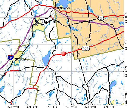
- OSM Map
- General Map
- Google Map
- MSN Map
Population change since 2000: +7.0%
 |
| Males: 515 | |
| Females: 515 |
| Median resident age: | 43.1 years |
| Maine median age: | 43.0 years |
Zip codes: 04987.
| Troy: | $56,486 |
| ME: | $69,543 |
Estimated per capita income in 2022: $29,760 (it was $14,027 in 2000)
Troy town income, earnings, and wages data
Estimated median house or condo value in 2022: $202,980 (it was $69,500 in 2000)
| Troy: | $202,980 |
| ME: | $290,600 |
Mean prices in 2022: all housing units: $270,070; detached houses: $293,055; townhouses or other attached units: $325,130; in 2-unit structures: $297,158; in 3-to-4-unit structures: $211,194; in 5-or-more-unit structures: $284,526; mobile homes: $128,233; occupied boats, rvs, vans, etc.: $21,180
Detailed information about poverty and poor residents in Troy, ME
Compare current foreclosures near Troy, ME:
| Photo | Address | Area | Beds / Baths | Price | Details |
|---|---|---|---|---|---|

|
#1
Hatch Rd
Brooks, ME 04921
|
1,092 sq. feet
|
1 baths 2 beds |
show details | |

|
#2
Hill Rd
Canaan, ME 04924
|
838 sq. feet
|
1 baths 2 beds |
show details | |

|
#3
Western Ave
Hampden, ME 04444
|
1,976 sq. feet
|
2 baths 4 beds |
show details | |

|
#4
Western Ave
Hampden, ME 04444
|
1,825 sq. feet
|
1 baths 3 beds |
show details | |

|
#5
Cooper Rd
Morrill, ME 04952
|
- sq. feet
|
- baths - beds |
show details | |

|
#6
Powers Rd
Pittsfield, ME 04967
|
- sq. feet
|
- baths - beds |
show details | |

|
#7
Hampden Rd
Carmel, ME 04419
|
- sq. feet
|
- baths - beds |
show details | |

|
#8
Spring St, Apt 3
Clinton, ME 04927
|
- sq. feet
|
- baths - beds |
show details | |

|
#9
Park Ave
Clinton, ME 04927
|
- sq. feet
|
- baths - beds |
show details | |

|
#10
Karen St
Palmyra, ME 04965
|
- sq. feet
|
- baths - beds |
show details |
| Photo | Address | Area | Beds / Baths | Price | Details |
|---|---|---|---|---|---|

|
#11
Indian Hill Ln
Frankfort, ME 04438
|
- sq. feet
|
- baths - beds |
show details | |

|
#12
E Benton Rd
Waterville, ME 04901
|
- sq. feet
|
- baths - beds |
show details | |

|
#13
Harrison St
Pittsfield, ME 04967
|
- sq. feet
|
- baths - beds |
show details | |

|
#14
Deer Meadow Dr
Albion, ME 04910
|
- sq. feet
|
- baths - beds |
show details | |

|
#15
Bellsqueeze Rd
Clinton, ME 04927
|
- sq. feet
|
- baths - beds |
show details | |

|
#16
Purple Heart Hwy
Brooks, ME 04921
|
- sq. feet
|
- baths - beds |
show details | |

|
#17
Belfast Rd
Thorndike, ME 04986
|
- sq. feet
|
- baths - beds |
show details | |

|
#18
Ames Ct
Pittsfield, ME 04967
|
- sq. feet
|
- baths - beds |
show details | |

|
Check over 1 million property listings on Foreclosure.com!
|
browse all offers | |||

- 97094.2%White alone
- 373.6%Two or more races
- 161.6%Hispanic
- 30.3%Black alone
- 20.2%American Indian alone
- 20.2%Asian alone

Races in Troy detailed stats: ancestries, foreign born residents, place of birth
According to our research of Maine and other state lists, there were 2 registered sex offenders living in Troy, Maine as of May 24, 2024.
The ratio of all residents to sex offenders in Troy is 515 to 1.
The ratio of registered sex offenders to all residents in this city is near the state average.
 Recent articles from our blog. Our writers, many of them Ph.D. graduates or candidates, create easy-to-read articles on a wide variety of topics.

 | Maine top Dem committed fraud (0 replies) |
| Cannabis industry (28 replies) |
| Maine tax-payer subsidies flowing to BIW (2 replies) |
| Moosehead Mfg opening? (10 replies) |
| Bento's Closed (22 replies) |
| Moving from Austin to Allagash (190 replies) |
Latest news from Troy, ME collected exclusively by city-data.com from local newspapers, TV, and radio stations
Ancestries: English (22.1%), Irish (13.5%), French (9.0%), United States (7.1%), German (5.5%), French Canadian (5.4%).
Current Local Time: EST time zone
Incorporated on 02/22/1812
Elevation: 472 feet
Land area: 34.8 square miles.
Population density: 30 people per square mile (very low).
8 residents are foreign born
| This town: | 0.8% |
| Maine: | 2.9% |
| Troy town: | 1.0% ($708) |
| Maine: | 1.5% ($1,417) |
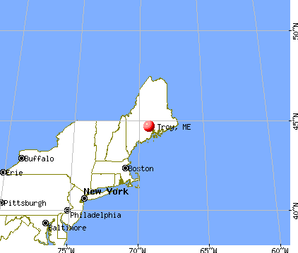
Nearest city with pop. 50,000+: Portland, ME  (86.1 miles , pop. 64,249).
Nearest city with pop. 200,000+: Boston, MA (187.0 miles , pop. 589,141).
Nearest city with pop. 1,000,000+: Bronx, NY (353.6 miles , pop. 1,332,650).
Nearest cities:
), ), ), )Latitude: 44.68 N, Longitude: 69.25 W
Area code commonly used in this area: 207


Single-family new house construction building permits:
- 2022: 12 buildings, average cost: $274,200
- 2021: 7 buildings, average cost: $259,200
- 2020: 9 buildings, average cost: $76,700
- 2019: 1 building, cost: $210,000
- 2018: 9 buildings, average cost: $249,800
- 2017: 5 buildings, average cost: $248,100
- 2015: 1 building, cost: $226,800
- 2013: 3 buildings, average cost: $145,000
- 2012: 5 buildings, average cost: $184,000
- 2011: 3 buildings, average cost: $133,300
- 2010: 2 buildings, average cost: $165,900
- 2009: 4 buildings, average cost: $178,900
- 2008: 3 buildings, average cost: $175,000
- 2007: 4 buildings, average cost: $181,200
- 2006: 9 buildings, average cost: $171,000
- 2005: 8 buildings, average cost: $150,200
- 2004: 12 buildings, average cost: $138,800
- 2003: 4 buildings, average cost: $132,800
- 2002: 10 buildings, average cost: $130,700


| Here: | 5.6% |
| Maine: | 3.4% |


- Educational services (14.9%)
- Health care (10.2%)
- Construction (6.1%)
- Accommodation & food services (5.0%)
- Agriculture, forestry, fishing & hunting (4.5%)
- Food & beverage stores (4.5%)
- Public administration (3.8%)

- Construction (12.2%)
- Educational services (11.7%)
- Agriculture, forestry, fishing & hunting (7.5%)
- Truck transportation (5.2%)
- Motor vehicle & parts dealers (4.7%)
- Food & beverage stores (4.2%)
- Accommodation & food services (4.2%)

- Educational services (18.1%)
- Health care (16.7%)
- Public administration (5.7%)
- Accommodation & food services (5.7%)
- Food & beverage stores (4.8%)
- Professional, scientific, technical services (4.3%)
- Textile mills & textile products (2.9%)

- Preschool, kindergarten, elementary, and middle school teachers (6.4%)
- Driver/sales workers and truck drivers (5.7%)
- Laborers and material movers, hand (4.7%)
- Other management occupations, except farmers and farm managers (4.0%)
- Nursing, psychiatric, and home health aides (3.5%)
- Electrical equipment mechanics and other installation, maintenance, and repair workers, including supervisors (3.5%)
- Secretaries and administrative assistants (3.3%)

- Driver/sales workers and truck drivers (10.3%)
- Electrical equipment mechanics and other installation, maintenance, and repair workers, including supervisors (7.0%)
- Preschool, kindergarten, elementary, and middle school teachers (4.7%)
- Other production occupations, including supervisors (4.7%)
- Construction traders workers except carpenters, electricians, painters, plumbers, and construction laborers (4.2%)
- Agricultural workers, including supervisors (4.2%)
- Material recording, scheduling, dispatching, and distributing workers (4.2%)

- Preschool, kindergarten, elementary, and middle school teachers (8.1%)
- Secretaries and administrative assistants (6.7%)
- Laborers and material movers, hand (6.2%)
- Other management occupations, except farmers and farm managers (5.7%)
- Registered nurses (4.8%)
- Nursing, psychiatric, and home health aides (4.8%)
- Other food preparation and serving workers, including supervisors (4.3%)
Average climate in Troy, Maine
Based on data reported by over 4,000 weather stations


Earthquake activity:
Troy-area historical earthquake activity is significantly above Maine state average. It is 78% smaller than the overall U.S. average.On 4/20/2002 at 10:50:47, a magnitude 5.3 (5.3 ML, Depth: 3.0 mi, Class: Moderate, Intensity: VI - VII) earthquake occurred 219.1 miles away from the city center
On 10/16/2012 at 23:12:25, a magnitude 4.7 (4.7 ML, Depth: 10.0 mi, Class: Light, Intensity: IV - V) earthquake occurred 102.0 miles away from Troy center
On 4/20/2002 at 10:50:47, a magnitude 5.2 (5.2 MB, 4.2 MS, 5.2 MW, 5.0 MW) earthquake occurred 220.3 miles away from the city center
On 10/7/1983 at 10:18:46, a magnitude 5.3 (5.1 MB, 5.3 LG, 5.1 ML) earthquake occurred 256.6 miles away from the city center
On 1/19/1982 at 00:14:42, a magnitude 4.7 (4.5 MB, 4.7 MD, 4.5 LG) earthquake occurred 142.1 miles away from the city center
On 2/26/1999 at 03:38:43, a magnitude 3.8 (3.8 LG, Depth: 2.0 mi, Class: Light, Intensity: II - III) earthquake occurred 18.8 miles away from Troy center
Magnitude types: regional Lg-wave magnitude (LG), body-wave magnitude (MB), duration magnitude (MD), local magnitude (ML), surface-wave magnitude (MS), moment magnitude (MW)
Natural disasters:
The number of natural disasters in Waldo County (19) is greater than the US average (15).Major Disasters (Presidential) Declared: 15
Emergencies Declared: 3
Causes of natural disasters: Floods: 14, Storms: 11, Snows: 3, Heavy Rains: 2, Winter Storms: 2, Blizzard: 1, Hurricane: 1, Ice Storm: 1, Landslide: 1, Snowfall: 1, Wind: 1, Other: 1 (Note: some incidents may be assigned to more than one category).

Colleges/universities with over 2000 students nearest to Troy:
- Husson University (about 26 miles; Bangor, ME; Full-time enrollment: 2,421)
- University of Maine (about 33 miles; Orono, ME; FT enrollment: 8,931)
- University of Maine at Augusta (about 36 miles; Augusta, ME; FT enrollment: 3,204)
- University of Maine at Farmington (about 44 miles; Farmington, ME; FT enrollment: 2,036)
- Saint Joseph's College of Maine (about 85 miles; Standish, ME; FT enrollment: 2,010)
- Southern Maine Community College (about 86 miles; South Portland, ME; FT enrollment: 4,666)
- University of Southern Maine (about 87 miles; Portland, ME; FT enrollment: 6,647)
Public elementary/middle school in Troy:
- TROY CENTRAL SCHOOL (Location: 733 BANGOR RD 30, Grades: KG-5)
Points of interest:
Notable locations in Troy: Rogers Corners (A), Troy Volunteer Fire Department (B). Display/hide their locations on the map
Cemeteries: Webb Cemetery (1), Webster Cemetery (2), Fairview Cemetery (3), Mount Holly Cemetery (4), Hathaway Cemetery (5). Display/hide their locations on the map
Reservoirs and swamps: Carlton Pond (A), Carlton Bog (B). Display/hide their locations on the map
Streams, rivers, and creeks: Shaw Brook (A). Display/hide its location on the map
Drinking water stations with addresses in Troy and their reported violations in the past:
SUNRISE RESTAURANT & BAKERY (Population served: 245, Groundwater):Past health violations:Past monitoring violations:
- MCL, Monthly (TCR) - In JUN-2011, Contaminant: Coliform. Follow-up actions: St Public Notif requested (JUN-29-2011), St Formal NOV issued (JUN-29-2011), St Public Notif received (JUL-29-2011), St Compliance achieved (JUL-29-2011)
- MCL, Monthly (TCR) - In JUL-2010, Contaminant: Coliform. Follow-up actions: St Public Notif requested (AUG-03-2010), St Formal NOV issued (AUG-03-2010), St Public Notif received (JUL-29-2011), St Compliance achieved (JUL-29-2011)
- MCL, Monthly (TCR) - In JUN-2010, Contaminant: Coliform. Follow-up actions: St Public Notif requested (JUN-29-2010), St Formal NOV issued (JUN-29-2010), St Public Notif received (JUL-29-2011), St Compliance achieved (JUL-29-2011)
- MCL, Monthly (TCR) - In NOV-2008, Contaminant: Coliform. Follow-up actions: St Public Notif requested (DEC-01-2008), St Formal NOV issued (DEC-01-2008), St Compliance achieved (JUN-22-2009), St Intentional no-action (SEP-15-2011)
- MCL, Monthly (TCR) - In NOV-2007, Contaminant: Coliform. Follow-up actions: St Public Notif requested (DEC-06-2007), St Formal NOV issued (DEC-06-2007), St Public Notif received (DEC-28-2007), St Compliance achieved (AUG-17-2009)
- Monitoring, Repeat Major (TCR) - In OCT-2007, Contaminant: Coliform (TCR). Follow-up actions: St Public Notif requested (DEC-05-2007), St Formal NOV issued (DEC-05-2007), St Public Notif received (JAN-30-2008), St Compliance achieved (JAN-31-2008)
- Monitoring, Repeat Major (TCR) - In OCT-2006, Contaminant: Coliform (TCR). Follow-up actions: St Public Notif requested (DEC-26-2006), St Violation/Reminder Notice (DEC-26-2006), St Admin Penalty assessed (AUG-09-2007), St Public Notif received (SEP-05-2007), St Compliance achieved (2 times from AUG-17-2009 to JUL-29-2011)
- Monitoring, Repeat Major (TCR) - In JUL-2005, Contaminant: Coliform (TCR). Follow-up actions: St Public Notif requested (AUG-02-2005), St Violation/Reminder Notice (AUG-02-2005), St Compliance achieved (JAN-05-2006), St Intentional no-action (AUG-16-2011)
- 17 routine major monitoring violations
- 11 minor monitoring violations
- 163 regular monitoring violations
| This town: | 2.5 people |
| Maine: | 2.3 people |
| This town: | 73.2% |
| Whole state: | 62.9% |
| This town: | 9.2% |
| Whole state: | 9.4% |
Likely homosexual households (counted as self-reported same-sex unmarried-partner households)
- Lesbian couples: 0.5% of all households
- Gay men: 0.0% of all households
| This town: | 13.7% |
| Whole state: | 10.9% |
| This town: | 6.0% |
| Whole state: | 4.1% |
For population 15 years and over in Troy:

- Never married: 21.6%
- Now married: 63.5%
- Separated: 0.4%
- Widowed: 6.0%
- Divorced: 8.4%
For population 25 years and over in Troy:
- High school or higher: 85.3%
- Bachelor's degree or higher: 14.2%
- Graduate or professional degree: 4.9%
- Unemployed: 7.2%
- Mean travel time to work (commute): 30.0 minutes


| Here: | 9.1 |
| Maine average: | 11.2 |

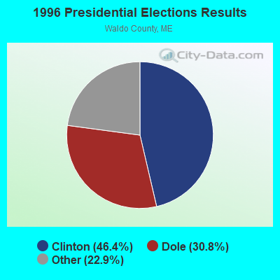
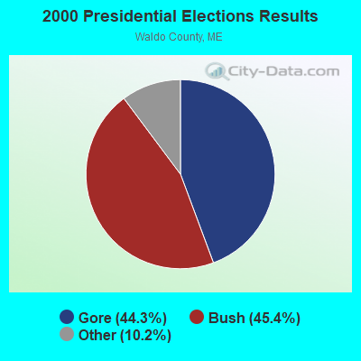


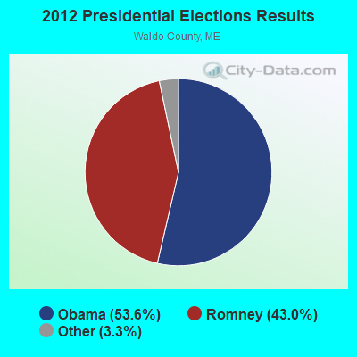


Graphs represent county-level data. Detailed 2008 Election Results
Religion statistics for Troy, ME (based on Waldo County data)
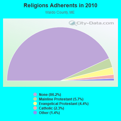
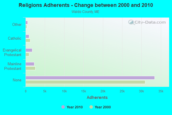
| Religion | Adherents | Congregations |
|---|---|---|
| Mainline Protestant | 2,204 | 20 |
| Evangelical Protestant | 1,711 | 23 |
| Catholic | 900 | 3 |
| Other | 554 | 7 |
| None | 33,417 | - |
Food Environment Statistics:
| This county: | 2.60 / 10,000 pop. |
| Maine: | 2.80 / 10,000 pop. |
| Waldo County: | 1.82 / 10,000 pop. |
| Maine: | 2.20 / 10,000 pop. |
| Here: | 7.02 / 10,000 pop. |
| Maine: | 5.75 / 10,000 pop. |
| Waldo County: | 8.84 / 10,000 pop. |
| Maine: | 11.02 / 10,000 pop. |
| This county: | 9.2% |
| Maine: | 8.2% |
| Waldo County: | 26.1% |
| Maine: | 25.0% |
Strongest AM radio stations in Troy:
- WSKW (1160 AM; 10 kW; SKOWHEGAN, ME; Owner: MOUNTAIN WIRELESS, INCORPORATED)
- WZON (620 AM; 5 kW; BANGOR, ME; Owner: THE ZONE CORPORATION)
- WABI (910 AM; 5 kW; BANGOR, ME; Owner: CLEAR CHANNEL BROADCASTING LICENSES, INC.)
- WTME (780 AM; 10 kW; RUMFORD, ME; Owner: MOUNTAIN VALLEY BROADCASTING, INC.)
- WFAU (1280 AM; 5 kW; GARDINER, ME; Owner: CAPSTAR TX LIMITED PARTNERSHIP)
- WDEA (1370 AM; 5 kW; ELLSWORTH, ME; Owner: CUMULUS LICENSING CORP.)
- WRKO (680 AM; 50 kW; BOSTON, MA; Owner: ENTERCOM BOSTON LICENSE, LLC)
- WTVL (1490 AM; 1 kW; WATERVILLE, ME; Owner: CITADEL BROADCASTING COMPANY)
- WEEI (850 AM; 50 kW; BOSTON, MA; Owner: ENTERCOM BOSTON LICENSE, LLC)
- WBZ (1030 AM; 50 kW; BOSTON, MA; Owner: INFINITY BROADCASTING OPERATIONS, INC.)
- WMTW (870 AM; 10 kW; GORHAM, ME; Owner: RADIO PARTNERS OF MAINE, L.P.)
- WCRN (830 AM; 50 kW; WORCESTER, MA; Owner: CARTER BROADCASTING CORPORATION)
- WNNZ (640 AM; 50 kW; WESTFIELD, MA; Owner: CLEAR CHANNEL BROADCASTING LICENSES, INC.)
Strongest FM radio stations in Troy:
- WWBX (97.1 FM; BANGOR, ME; Owner: CLEAR CHANNEL BROADCASTING LICENSES, INC.)
- WBFB (104.7 FM; BELFAST, ME; Owner: CLEAR CHANNEL BROADCASTING LICENSES, INC.)
- WFZX (101.7 FM; SEARSPORT, ME; Owner: CLEAR CHANNEL BROADCASTING LICENSES, INC.)
- WQCB (106.5 FM; BREWER, ME; Owner: CUMULUS LICENSING CORP.)
- WCTB (93.5 FM; FAIRFIELD, ME; Owner: MOUNTAIN WIRELESS, INC.)
- WKIT-FM (100.3 FM; BREWER, ME; Owner: THE ZONE CORPORATION)
- WMEP (90.5 FM; CAMDEN, ME; Owner: MAINE PUBLIC BROADCASTING CORP.)
- WQSS (102.5 FM; CAMDEN, ME; Owner: CLEAR CHANNEL BROADCASTING LICENSES, INC.)
- WTOS-FM (105.1 FM; SKOWHEGAN, ME; Owner: CAPSTAR TX LIMITED PARTNERSHIP)
- WJCX (99.5 FM; PITTSFIELD, ME; Owner: CSN INTERNATIONAL)
- WWMJ (95.7 FM; ELLSWORTH, ME; Owner: CUMULUS LICENSING CORP.)
- WHQO (107.9 FM; SKOWHEGAN, ME; Owner: MOUNTAIN WIRELESS, INC.)
- WWWA (95.3 FM; WINSLOW, ME; Owner: LIGHT OF LIFE MINISTRIES, INC.)
- WGUY (102.1 FM; DEXTER, ME; Owner: CONCORD MEDIA GROUP, INC.)
- WVOM (103.9 FM; HOWLAND, ME; Owner: CLEAR CHANNEL BROADCASTING LICENSES, INC.)
- WHCF (88.5 FM; BANGOR, ME; Owner: BANGOR BAPTIST CHURCH)
- WMEH (90.9 FM; BANGOR, ME; Owner: MAINE PUBLIC BROADCASTING CORPORATION)
- WERU-FM (89.9 FM; BLUE HILL, ME; Owner: SALT POND COMMUNITY B/C COMPANY)
- WEZQ (92.9 FM; BANGOR, ME; Owner: CUMULUS LICENSING CORP.)
- WEBB (98.5 FM; WATERVILLE, ME; Owner: CITADEL BROADCASTING COMPANY)
TV broadcast stations around Troy:
- WABI-TV (Channel 5; BANGOR, ME; Owner: COMMUNITY BROADCASTING SERVICE)
- W36CK (Channel 36; BANGOR, ME; Owner: TRINITY BROADCASTING NETWORK)
- WCKD-LP (Channel 30; BANGOR/DEDHAM, ME; Owner: J. MCLEOD, ME FAMILY B/CING., INC.)
Troy fatal accident list:
Oct 31, 2021 11:21 AM, Sr-220, Lat: 44.707731, Lon: -69.292350, Vehicles: 1, Persons: 1, Fatalities: 1
Jul 20, 2015 08:43 PM, N. Dixmont Road, Lat: 44.704731, Lon: -69.215000, Vehicles: 1, Persons: 4, Fatalities: 1, Drunk persons involved: 1
Dec 5, 2010 05:33 PM, Us-202, Lat: 44.662975, Lon: -69.258328, Vehicles: 1, Persons: 2, Fatalities: 1, Drunk persons involved: 1
Dec 15, 2010 10:55 AM, Us-202, Lat: 44.662914, Lon: -69.258069, Vehicles: 1, Persons: 1, Fatalities: 1
Oct 5, 2008 01:50 AM, Sr-220, Lat: 44.652540, Lon: -69.301590, Vehicles: 1, Persons: 3, Fatalities: 1, Drunk persons involved: 1
Jul 19, 2001 00:20 AM, Ward Hill Road, Vehicles: 1, Persons: 1, Fatalities: 1, Drunk persons involved: 1
- National Bridge Inventory (NBI) Statistics
- 2Number of bridges
- 10ft / 2.8mTotal length
- 1,492Total average daily traffic
- 74Total average daily truck traffic
- 2,387Total future (year 2036) average daily traffic
FCC Registered Antenna Towers:
3- Mark L Gartley, Ward Hill Road (Lat: 44.675611 Lon: -69.238139), Type: 60.6, Overall height: 57.9 m, Registrant: Holland & Knight LLP, Pconnolly@hklaw.Com, , Washi-ngton, Phone: (202) 862-5989
- Erik Brooks, Ward Hill Road (Lat: 44.675611 Lon: -69.238139), Type: 60.6, Overall height: 57.9 m, Registrant: Holland & Knight LLP, Pconnolly@hklaw.Com, , Washi-ngton, Phone: (202) 862-5989
- STEVEN T CAMPBELL, Ward Hill Road (Lat: 44.675611 Lon: -69.238139), Type: 60.6, Structure height: 23027 m, Overall height: 57.9 m, Registrant: Holland & Knight LLP, Peter.Connolly@hklaw.Com, , Washi-ngton, Phone: (202) 955-3000
FCC Registered Microwave Towers:
2- TROY_USF, Ward Hill Road (Lat: 44.675611 Lon: -69.238139), Type: Tower, Structure height: 57.9 m, Overall height: 60.6 m, Call Sign: WQOF221,
Assigned Frequencies: 6063.80 MHz, Grant Date: 08/03/2021, Expiration Date: 09/07/2031, Certifier: Steven T Campbell, Registrant: Wilkinson Barker Knauer, LLP, 1800 M Street Nw, Suite 800n, Washington, DC 20036, Phone: (202) 383-3420, Fax: (202) 783-5851, Email:
- East Troy, Waroad Hill Road (Lat: 44.675528 Lon: -69.238139), Type: Ltower, Structure height: 58.5 m, Overall height: 59.4 m, Call Sign: WQSJ410,
Assigned Frequencies: 18015.0 MHz, 19425.0 MHz, 18015.0 MHz, 19425.0 MHz, 18015.0 MHz, 19425.0 MHz, 18015.0 MHz, 19425.0 MHz, 18015.0 MHz, 19425.0 MHz... (+17 more), Grant Date: 09/26/2013, Expiration Date: 09/26/2023, Cancellation Date: 09/17/2020, Certifier: Jessica B Lyons, Registrant: At&t Services, Inc., 208 S. Akard Street, Room 2100, Dallas, TX 75202, Phone: (855) 699-7073, Email:
FCC Registered Amateur Radio Licenses:
6- Call Sign: K1DY, Previous Call Sign: W3HQT, Licensee ID: L00431925, Grant Date: 06/02/2017, Expiration Date: 08/21/2027, Certifier: Stuart W Olson, Registrant: Stuart W Olson, 502 Barker Rd, Troy, ME 04987
- Call Sign: K2YSY, Licensee ID: L00133908, Grant Date: 04/26/1999, Expiration Date: 04/21/2009, Cancellation Date: 09/22/2007, Registrant: Peter A Sneed, 28 Rutland Road, Troy, ME 04987
- Call Sign: N1OZU, Licensee ID: L00840564, Grant Date: 04/07/2015, Expiration Date: 04/07/2025, Certifier: Robert W Greenwood, Registrant: Robert W Greenwood, 464 Whitaker Road, Troy, ME 04987
- Call Sign: WP2AEI, Licensee ID: L00172262, Grant Date: 09/16/2002, Expiration Date: 09/01/2012, Cancellation Date: 09/03/2014, Certifier: Stephen R Kramar, Registrant: Stephen R Kramar, 49 Myrick Road, Troy, ME 04987-3406
- Call Sign: WP2AEM, Licensee ID: L00172263, Grant Date: 07/18/2012, Expiration Date: 09/01/2022, Certifier: Phyllis J Kramar, Registrant: Phyllis J Kramar, 49 Myrick Road, Troy, ME 04987-3406
- Call Sign: K1YSY, Previous Call Sign: K2YSY, Licensee ID: L00133908, Grant Date: 09/22/2007, Expiration Date: 09/22/2017, Cancellation Date: 09/24/2019, Certifier: Peter A Sneed, Registrant: Peter A Sneed, 28 Rutland Road, Troy, ME 04987
FAA Registered Aircraft:
4- Aircraft: STINSON 10 (Category: Land, Seats: 3, Weight: Up to 12,499 Pounds, Speed: 90 mph), Engine: CONT MOTOR A80 SERIES (80 HP) (Reciprocating)
N-Number: 27762, N27762, N-27762, Serial Number: 7707, Year manufactured: 1940, Certificate Issue Date: 05/09/1974
Registrant (Individual): Donald K Hodges, Route Us 202, Troy, ME 04987 - Aircraft: CAMERON BALLOONS US V-77 (Category: Land, Seats: 4, Weight: Up to 12,499 Pounds), Engine: None
N-Number: 6028L, N6028L, N-6028L, Serial Number: 5477, Year manufactured: 1989, Airworthiness Date: 02/06/1989, Certificate Issue Date: 01/19/1990
Registrant (Individual): Bruce A Towle, 416 Myrick Rd, Troy, ME 04987 - Aircraft: CESSNA T210F (Category: Land, Seats: 4, Weight: Up to 12,499 Pounds, Speed: 141 mph), Engine: CONT MOTOR GTSIO-520-C (340 HP) (Reciprocating)
N-Number: 6195R, N6195R, N-6195R, Serial Number: T210-0095, Year manufactured: 1966, Airworthiness Date: 02/11/1966, Certificate Issue Date: 02/06/2020
Registrant (Co-Owned): Mark K Trustee Simmons, 77 N Dixmont Rd, Troy, ME 04987, Other Owners: Margaret M Trustee Simmons - Aircraft: RAPTOR TRIKE (Category: Land, Seats: 2, Weight: Up to 12,499 Pounds), Engine: ROTAX 503 DCDI (52 HP) (2 Cycle)
N-Number: 6140T, N6140T, N-6140T, Serial Number: 101, Year manufactured: 2001, Airworthiness Date: 01/23/2008, Certificate Issue Date: 08/15/2007
Registrant (Individual): Fred H Delano, 600 Detroit Rd, Troy, ME 04987

- 76.4%Fuel oil, kerosene, etc.
- 19.1%Wood
- 2.5%Bottled, tank, or LP gas
- 1.3%Coal or coke
- 0.6%Electricity

- 58.8%Fuel oil, kerosene, etc.
- 37.3%Wood
- 3.9%Other fuel
Troy compared to Maine state average:
- Unemployed percentage below state average.
- Black race population percentage significantly below state average.
- Foreign-born population percentage significantly below state average.
- Renting percentage below state average.
- Length of stay since moving in significantly above state average.
- Number of rooms per house significantly below state average.
- House age significantly below state average.
- Percentage of population with a bachelor's degree or higher below state average.