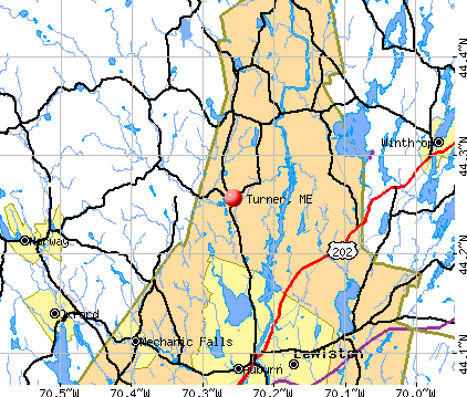
Turner, Maine
Submit your own pictures of this town and show them to the world
- OSM Map
- General Map
- Google Map
- MSN Map
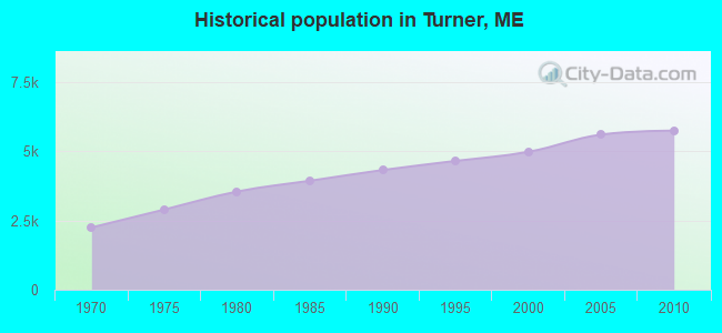
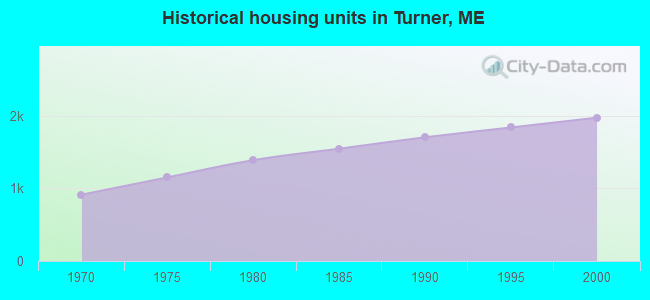
Population change since 2000: +15.3%
 |
| Males: 2,860 | |
| Females: 2,874 |
| Median resident age: | 41.1 years |
| Maine median age: | 43.0 years |
Zip codes: 04282.
| Turner: | $81,895 |
| ME: | $69,543 |
Estimated per capita income in 2022: $41,179 (it was $23,439 in 2000)
Turner town income, earnings, and wages data
Estimated median house or condo value in 2022: $284,344 (it was $99,400 in 2000)
| Turner: | $284,344 |
| ME: | $290,600 |
Mean prices in 2022: all housing units: $249,170; detached houses: $267,476; townhouses or other attached units: $202,361; in 2-unit structures: $200,400; in 3-to-4-unit structures: $182,257; in 5-or-more-unit structures: $238,166; mobile homes: $73,615
Detailed information about poverty and poor residents in Turner, ME


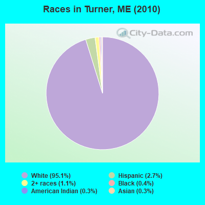
- 5,45395.1%White alone
- 1562.7%Hispanic
- 621.1%Two or more races
- 240.4%Black alone
- 180.3%American Indian alone
- 170.3%Asian alone
- 20.03%Native Hawaiian and Other
Pacific Islander alone - 20.03%Other race alone
Races in Turner detailed stats: ancestries, foreign born residents, place of birth
According to our research of Maine and other state lists, there were 9 registered sex offenders living in Turner, Maine as of May 18, 2024.
The ratio of all residents to sex offenders in Turner is 637 to 1.
The ratio of registered sex offenders to all residents in this city is lower than the state average.
 Recent articles from our blog. Our writers, many of them Ph.D. graduates or candidates, create easy-to-read articles on a wide variety of topics.

 | Belfast ME. Winters Can I survive them? (31 replies) |
| Maine weather thread (3207 replies) |
| Does Maine appeal to any young people these days? (108 replies) |
| Aroostook vs Wash Co. for self-sufficiency? (22 replies) |
| Input on this: Maine effort to tax nonprofits raises eyebrows across the US (77 replies) |
| Researching Maine for possible relocation (41 replies) |
Latest news from Turner, ME collected exclusively by city-data.com from local newspapers, TV, and radio stations
Ancestries: English (23.1%), French (17.3%), French Canadian (11.3%), United States (11.2%), Irish (9.1%), German (6.6%).
Current Local Time: EST time zone
Incorporated on 07/07/1786
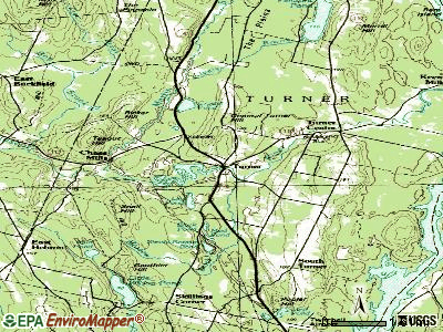
Elevation: 303 feet
Land area: 59.6 square miles.
Population density: 96 people per square mile (very low).
126 residents are foreign born (1.6% Latin America, 0.5% Europe).
| This town: | 2.5% |
| Maine: | 2.9% |
| Turner town: | 1.4% ($1,441) |
| Maine: | 1.5% ($1,417) |
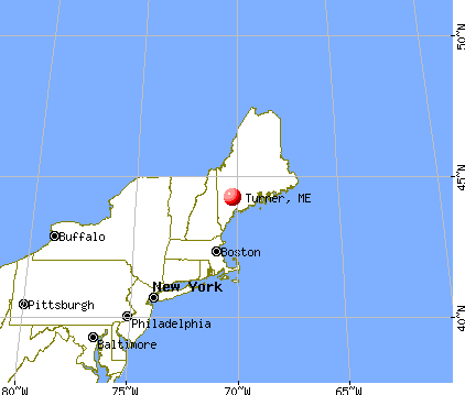
Nearest city with pop. 50,000+: Portland, ME  (41.6 miles , pop. 64,249).
Nearest city with pop. 200,000+: Boston, MA (141.1 miles , pop. 589,141).
Nearest city with pop. 1,000,000+: Bronx, NY (300.1 miles , pop. 1,332,650).
Nearest cities:
), ), ), ), Latitude: 44.27 N, Longitude: 70.25 W
Area code: 207

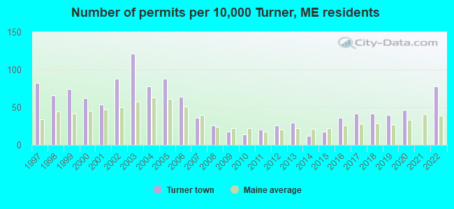
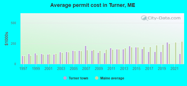
Single-family new house construction building permits:
- 2022: 39 buildings, average cost: $126,600
- 2020: 23 buildings, average cost: $265,300
- 2019: 20 buildings, average cost: $151,000
- 2018: 21 buildings, average cost: $151,000
- 2017: 21 buildings, average cost: $151,000
- 2016: 18 buildings, average cost: $186,500
- 2015: 9 buildings, average cost: $206,800
- 2014: 6 buildings, average cost: $221,200
- 2013: 15 buildings, average cost: $183,000
- 2012: 13 buildings, average cost: $183,500
- 2011: 10 buildings, average cost: $197,600
- 2010: 7 buildings, average cost: $135,800
- 2009: 9 buildings, average cost: $140,000
- 2008: 13 buildings, average cost: $164,300
- 2007: 18 buildings, average cost: $223,500
- 2006: 32 buildings, average cost: $166,100
- 2005: 44 buildings, average cost: $165,600
- 2004: 39 buildings, average cost: $149,800
- 2003: 60 buildings, average cost: $148,200
- 2002: 44 buildings, average cost: $121,400
- 2001: 27 buildings, average cost: $119,200
- 2000: 31 buildings, average cost: $127,400
- 1999: 37 buildings, average cost: $133,100
- 1998: 33 buildings, average cost: $125,100
- 1997: 41 buildings, average cost: $100,000
| Here: | 2.9% |
| Maine: | 3.4% |
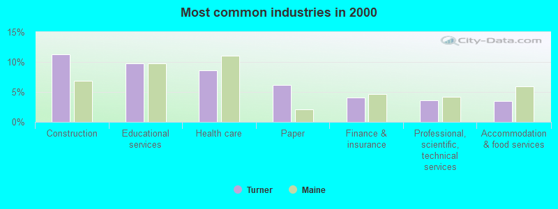
- Construction (11.3%)
- Educational services (9.8%)
- Health care (8.6%)
- Paper (6.1%)
- Finance & insurance (4.1%)
- Professional, scientific, technical services (3.6%)
- Accommodation & food services (3.5%)
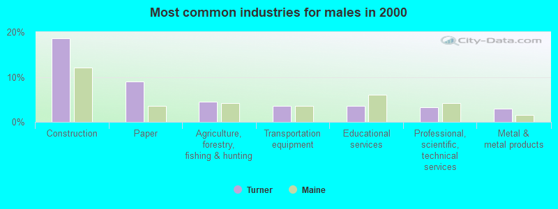
- Construction (18.6%)
- Paper (8.9%)
- Agriculture, forestry, fishing & hunting (4.5%)
- Transportation equipment (3.6%)
- Educational services (3.5%)
- Professional, scientific, technical services (3.2%)
- Metal & metal products (2.9%)
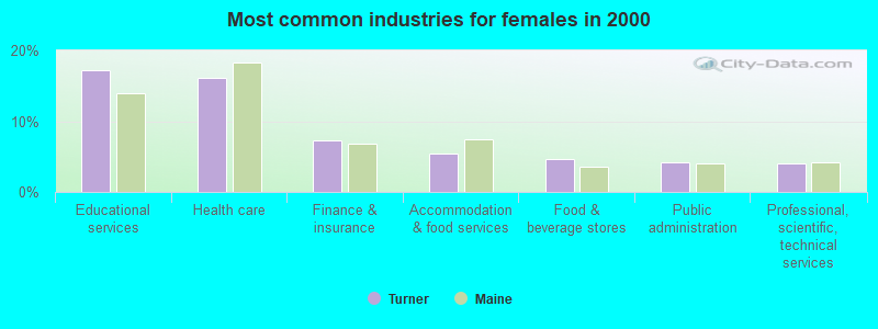
- Educational services (17.2%)
- Health care (16.1%)
- Finance & insurance (7.3%)
- Accommodation & food services (5.5%)
- Food & beverage stores (4.7%)
- Public administration (4.2%)
- Professional, scientific, technical services (4.0%)
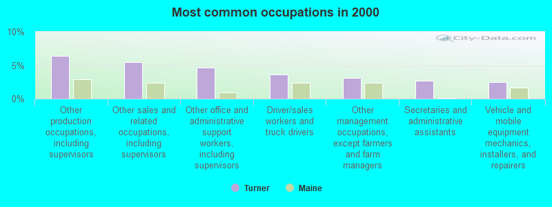
- Other production occupations, including supervisors (6.4%)
- Other sales and related occupations, including supervisors (5.5%)
- Other office and administrative support workers, including supervisors (4.6%)
- Driver/sales workers and truck drivers (3.7%)
- Other management occupations, except farmers and farm managers (3.1%)
- Secretaries and administrative assistants (2.7%)
- Vehicle and mobile equipment mechanics, installers, and repairers (2.5%)
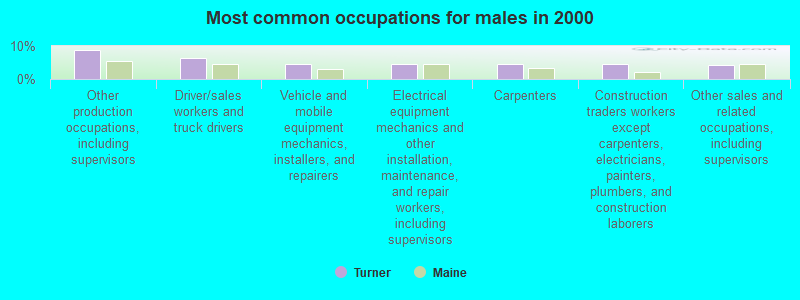
- Other production occupations, including supervisors (8.9%)
- Driver/sales workers and truck drivers (6.5%)
- Vehicle and mobile equipment mechanics, installers, and repairers (4.7%)
- Electrical equipment mechanics and other installation, maintenance, and repair workers, including supervisors (4.6%)
- Carpenters (4.6%)
- Construction traders workers except carpenters, electricians, painters, plumbers, and construction laborers (4.5%)
- Other sales and related occupations, including supervisors (4.1%)
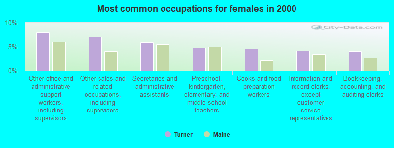
- Other office and administrative support workers, including supervisors (8.0%)
- Other sales and related occupations, including supervisors (7.0%)
- Secretaries and administrative assistants (5.9%)
- Preschool, kindergarten, elementary, and middle school teachers (4.7%)
- Cooks and food preparation workers (4.5%)
- Information and record clerks, except customer service representatives (4.1%)
- Bookkeeping, accounting, and auditing clerks (4.0%)
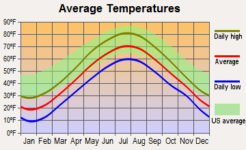
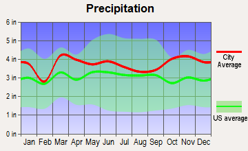
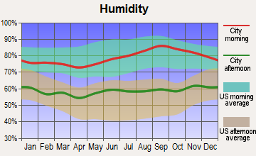
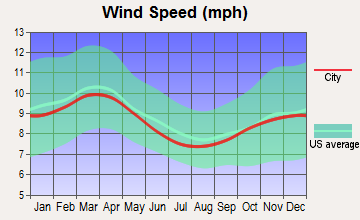
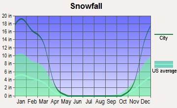
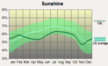
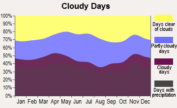
Average climate in Turner, Maine
Based on data reported by over 4,000 weather stations
(lower is better)
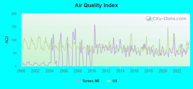
Air Quality Index (AQI) level in 2023 was 63.9. This is about average.
| City: | 63.9 |
| U.S.: | 72.6 |
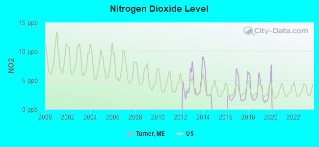
Nitrogen Dioxide (NO2) [ppb] level in 2019 was 2.80. This is significantly better than average. Closest monitor was 11.8 miles away from the city center.
| City: | 2.80 |
| U.S.: | 5.11 |
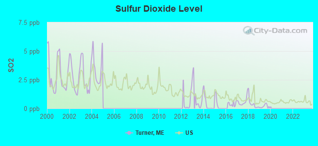
Sulfur Dioxide (SO2) [ppb] level in 2019 was 0.185. This is significantly better than average. Closest monitor was 11.7 miles away from the city center.
| City: | 0.185 |
| U.S.: | 1.515 |
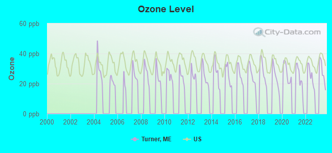
Ozone [ppb] level in 2023 was 28.1. This is about average. Closest monitor was 13.9 miles away from the city center.
| City: | 28.1 |
| U.S.: | 33.3 |
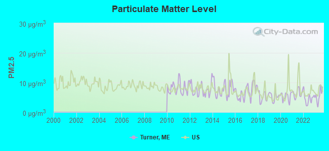
Particulate Matter (PM2.5) [µg/m3] level in 2023 was 5.63. This is significantly better than average. Closest monitor was 12.4 miles away from the city center.
| City: | 5.63 |
| U.S.: | 8.11 |
Earthquake activity:
Turner-area historical earthquake activity is significantly above Maine state average. It is 75% smaller than the overall U.S. average.On 4/20/2002 at 10:50:47, a magnitude 5.3 (5.3 ML, Depth: 3.0 mi, Class: Moderate, Intensity: VI - VII) earthquake occurred 171.4 miles away from Turner center
On 10/16/2012 at 23:12:25, a magnitude 4.7 (4.7 ML, Depth: 10.0 mi, Class: Light, Intensity: IV - V) earthquake occurred 50.6 miles away from Turner center
On 4/20/2002 at 10:50:47, a magnitude 5.2 (5.2 MB, 4.2 MS, 5.2 MW, 5.0 MW) earthquake occurred 172.3 miles away from Turner center
On 10/7/1983 at 10:18:46, a magnitude 5.3 (5.1 MB, 5.3 LG, 5.1 ML) earthquake occurred 204.6 miles away from the city center
On 1/19/1982 at 00:14:42, a magnitude 4.7 (4.5 MB, 4.7 MD, 4.5 LG) earthquake occurred 85.9 miles away from Turner center
On 2/26/1999 at 03:38:43, a magnitude 3.8 (3.8 LG, Depth: 2.0 mi, Class: Light, Intensity: II - III) earthquake occurred 38.8 miles away from the city center
Magnitude types: regional Lg-wave magnitude (LG), body-wave magnitude (MB), duration magnitude (MD), local magnitude (ML), surface-wave magnitude (MS), moment magnitude (MW)
Natural disasters:
The number of natural disasters in Androscoggin County (28) is a lot greater than the US average (15).Major Disasters (Presidential) Declared: 21
Emergencies Declared: 7
Causes of natural disasters: Floods: 17, Storms: 12, Snows: 7, Winter Storms: 4, Hurricanes: 3, Heavy Rains: 2, Blizzard: 1, Ice Storm: 1, Mudslide: 1, Snowfall: 1, Snowstorm: 1, Tornado: 1, Wind: 1, Other: 2 (Note: some incidents may be assigned to more than one category).
Hospitals and medical centers near Turner:
- SEVILLE PARK PLAZA (Nursing Home, about 10 miles away; AUBURN, ME)
- MONTELLO MANOR (Nursing Home, about 11 miles away; LEWISTON, ME)
- LOVELETT HEALTH CARE CENTER (Nursing Home, about 12 miles away; AUBURN, ME)
- AUBURN NURSING HOME (Nursing Home, about 12 miles away; AUBURN, ME)
- GOOD SHEPHERD HEALTH CARE - AUBURN (Nursing Home, about 12 miles away; AUBURN, ME)
- PROMENADE HEALTH CARE FACILITY (Nursing Home, about 12 miles away; AUBURN, ME)
- CENTRAL MAINE MEDICAL CENTER Acute Care Hospitals (about 12 miles away; LEWISTON, ME)
Airports located in Turner:
- Twitchell Airport (3B5) (Runways: 4, Itinerant Ops: 9,000, Local Ops: 27,000)
Colleges/universities with over 2000 students nearest to Turner:
- University of Maine at Augusta (about 23 miles; Augusta, ME; Full-time enrollment: 3,204)
- University of Maine at Farmington (about 29 miles; Farmington, ME; FT enrollment: 2,036)
- Saint Joseph's College of Maine (about 33 miles; Standish, ME; FT enrollment: 2,010)
- University of Southern Maine (about 42 miles; Portland, ME; FT enrollment: 6,647)
- Southern Maine Community College (about 43 miles; South Portland, ME; FT enrollment: 4,666)
- University of New England (about 57 miles; Biddeford, ME; FT enrollment: 4,539)
- Plymouth State University (about 81 miles; Plymouth, NH; FT enrollment: 4,838)
Public high school in Turner:
- LEAVITT AREA HIGH SCHOOL (Location: 21 MATTHEWS WAY, Grades: 9-12)
Private high school in Turner:
Public elementary/middle schools in Turner:
- TURNER PRIMARY SCHOOL (Location: 59 COBB ROAD, Grades: PK-3)
- TRIPP MIDDLE SCHOOL (Location: 65 MATTHEWS WAY, Grades: 7-8)
- TURNER ELEMENTARY SCHOOL (Location: 91 MATTHEWS WAY, Grades: 4-6)
Points of interest:
Notable locations in Turner: Martin Stream Campsites (A), Keens Mills (B), Turner Volunteer Fire Department North Station (C), Turner Volunteer Fire Department South End Station (D), Turner Volunteer Fire Department Central Station (E). Display/hide their locations on the map
Churches in Turner include: North Turner Presbyterian Church (A), Turner Village Church (B). Display/hide their locations on the map
Cemeteries: Wood Street Cemetery (1), Wilson Hill Cemetery (2), Maple Grove Cemetery (3), Harlow Cemetery (4), Turner Centerville Cemetery (5), Bear Pond Cemetery (6), Upper Street Cemetery (7). Display/hide their locations on the map
Lakes and reservoirs: Black Pond (A), Crystal Pond (B), Frog Pond (C), Lard Pond (D), Lily Pond (E), Little Wilson Pond (F), Mud Pond (G), Pickerel Pond (H). Display/hide their locations on the map
Streams, rivers, and creeks: Lively Brook (A), Red Brook (B), Martin Stream (C), Meadow Brook (D), Nezinscot River (E), House Brook (F), Bradford Brook (G), Blanchard Stream (H). Display/hide their locations on the map
Birthplace of: Eugene Hale - Politician, Royal Emerson Whitman - Army officer.
Drinking water stations with addresses in Turner and their reported violations in the past:
MSAD 52 LEAVITT AREA HIGH SCH (Population served: 678, Groundwater):Past monitoring violations:FORE SEASONS RESTAURANT (Population served: 675, Groundwater):
- One routine major monitoring violation
Past monitoring violations:MSAD 52 GREENE CENTRAL SCHOOL (Population served: 451, Groundwater):
- 2 routine major monitoring violations
- 2 regular monitoring violations
Past health violations:POMDOROS ITALIAN BISTRO (Population served: 425, Groundwater):Past monitoring violations:
- MCL, Monthly (TCR) - In OCT-2011, Contaminant: Coliform. Follow-up actions: St Public Notif requested (NOV-07-2011), St Formal NOV issued (NOV-07-2011), St Compliance achieved (NOV-30-2011), St Public Notif received (DEC-07-2011)
- MCL, Monthly (TCR) - In OCT-2010, Contaminant: Coliform. Follow-up actions: St Public Notif requested (OCT-20-2010), St Formal NOV issued (OCT-20-2010), St Public Notif received (NOV-16-2010), St Compliance achieved (NOV-17-2010)
- MCL, Monthly (TCR) - In SEP-2009, Contaminant: Coliform. Follow-up actions: St Public Notif requested (SEP-16-2009), St Formal NOV issued (SEP-16-2009), St Public Notif received (OCT-16-2009), St Compliance achieved (OCT-21-2009)
- One routine major monitoring violation
Past health violations:MSAD 52 TRIPP MIDDLE SCHOOL (Population served: 389, Groundwater):Past monitoring violations:
- MCL, Monthly (TCR) - In JUN-2013, Contaminant: Coliform. Follow-up actions: St Public Notif requested (JUN-20-2013), St Formal NOV issued (JUN-20-2013), St Public Notif received (JUN-27-2013), St Compliance achieved (JUL-29-2013)
- MCL, Monthly (TCR) - In JUL-2012, Contaminant: Coliform. Follow-up actions: St Public Notif requested (JUL-25-2012), St Formal NOV issued (JUL-25-2012), St Compliance achieved (AUG-27-2012), St Public Notif received (OCT-18-2012)
- MCL, Monthly (TCR) - In OCT-2009, Contaminant: Coliform. Follow-up actions: St Public Notif requested (OCT-07-2009), St Formal NOV issued (OCT-07-2009), St Compliance achieved (OCT-04-2011), St Public Notif received (MAR-01-2012)
- 3 routine major monitoring violations
- 3 regular monitoring violations
Past monitoring violations:MSAD 52 TURNER PRIMARY SCHOOL (Population served: 286, Groundwater):
- One routine major monitoring violation
Past health violations:MSAD 52 LEEDS CENTRAL SCHOOL (Population served: 262, Groundwater):Past monitoring violations:
- MCL, Monthly (TCR) - In MAY-2012, Contaminant: Coliform. Follow-up actions: St Public Notif requested (JUN-01-2012), St Formal NOV issued (JUN-01-2012), St Compliance achieved (JUN-28-2012), St Public Notif received (SEP-11-2012)
- MCL, Monthly (TCR) - Between OCT-2006 and DEC-2006, Contaminant: Coliform. Follow-up actions: St Public Notif requested (OCT-25-2006), St Violation/Reminder Notice (OCT-25-2006), St Public Notif received (NOV-14-2006), St Compliance achieved (NOV-15-2006)
- Follow-up Or Routine LCR Tap M/R - In OCT-01-2006, Contaminant: Lead and Copper Rule. Follow-up actions: St Public Notif requested (FEB-02-2009), St Formal NOV issued (FEB-02-2009), St Public Notif received (MAR-25-2009), St Compliance achieved (SEP-30-2009)
- One routine major monitoring violation
Past health violations:MSAD 52 TURNER ELEM SCHOOL (Population served: 200, Groundwater):Past monitoring violations:
- MCL, Monthly (TCR) - Between JUL-2007 and SEP-2007, Contaminant: Coliform. Follow-up actions: St Public Notif requested (SEP-07-2007), St Formal NOV issued (SEP-07-2007), St Public Notif received (2 times from SEP-21-2007 to SEP-21-2007), St Compliance achieved (MAR-12-2008)
- One routine major monitoring violation
Past monitoring violations:
- One routine major monitoring violation
Drinking water stations with addresses in Turner that have no violations reported:
- ANTIGONIS PIZZA-TURNER (Population served: 141, Primary Water Source Type: Groundwater)
- TURNER SQUARE APARTMENTS (Population served: 63, Primary Water Source Type: Groundwater)
| This town: | 2.6 people |
| Maine: | 2.3 people |
| This town: | 74.8% |
| Whole state: | 62.9% |
| This town: | 9.9% |
| Whole state: | 9.4% |
Likely homosexual households (counted as self-reported same-sex unmarried-partner households)
- Lesbian couples: 0.5% of all households
- Gay men: 0.6% of all households
| This town: | 5.5% |
| Whole state: | 10.9% |
| This town: | 2.2% |
| Whole state: | 4.1% |
3 people in group homes intended for adults in 2010
6 people in other noninstitutional group quarters in 2000
3 people in homes for the mentally retarded in 2000
Banks with branches in Turner (2011 data):
- Androscoggin Savings Bank: Turner Branch at 207 Auburn Rd Route 4, branch established on 1990/12/31. Info updated 2008/07/01: Bank assets: $707.2 mil, Deposits: $506.9 mil, headquarters in Lewiston, ME, positive income, Commercial Lending Specialization, 13 total offices, Holding Company: Androscoggin Bancorp, Mhc
For population 15 years and over in Turner:
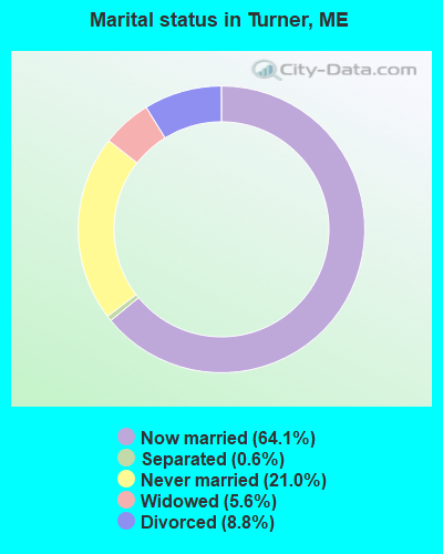
- Never married: 21.0%
- Now married: 64.1%
- Separated: 0.6%
- Widowed: 5.6%
- Divorced: 8.8%
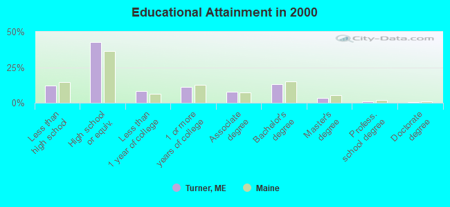
For population 25 years and over in Turner:
- High school or higher: 88.0%
- Bachelor's degree or higher: 18.0%
- Graduate or professional degree: 4.9%
- Unemployed: 2.1%
- Mean travel time to work (commute): 26.9 minutes
| Here: | 9.1 |
| Maine average: | 11.2 |
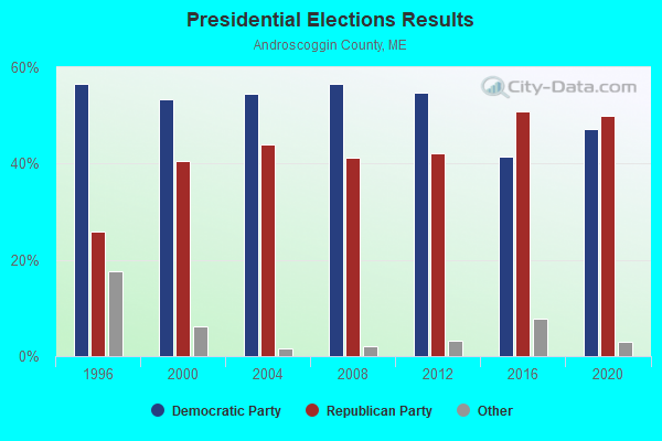
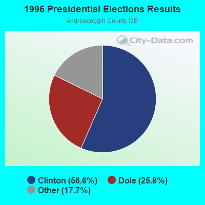
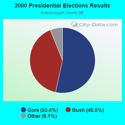
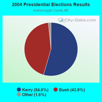
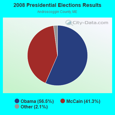
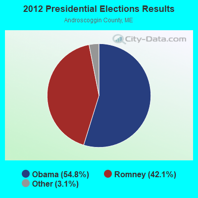
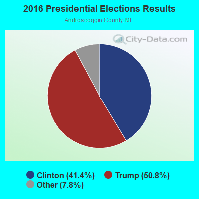
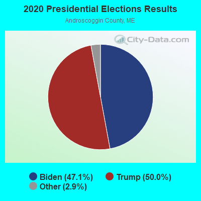
Graphs represent county-level data. Detailed 2008 Election Results
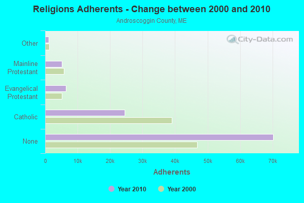
Religion statistics for Turner, ME (based on Androscoggin County data)
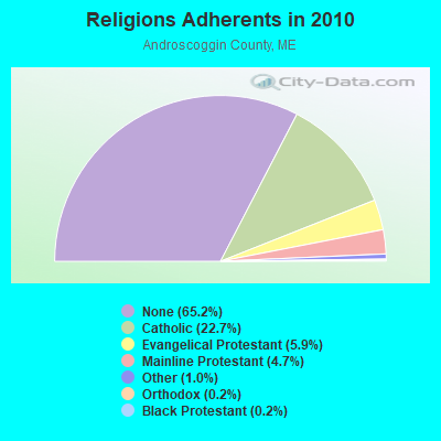
| Religion | Adherents | Congregations |
|---|---|---|
| Catholic | 24,480 | 6 |
| Evangelical Protestant | 6,383 | 37 |
| Mainline Protestant | 5,082 | 27 |
| Other | 1,097 | 8 |
| Orthodox | 225 | 1 |
| Black Protestant | 182 | 1 |
| None | 70,253 | - |
Food Environment Statistics:
| Here: | 1.69 / 10,000 pop. |
| State: | 2.80 / 10,000 pop. |
| Androscoggin County: | 0.19 / 10,000 pop. |
| Maine: | 0.14 / 10,000 pop. |
| Here: | 1.97 / 10,000 pop. |
| Maine: | 2.20 / 10,000 pop. |
| This county: | 5.90 / 10,000 pop. |
| State: | 5.75 / 10,000 pop. |
| Androscoggin County: | 7.87 / 10,000 pop. |
| Maine: | 11.02 / 10,000 pop. |
| Androscoggin County: | 8.0% |
| State: | 8.2% |
| Androscoggin County: | 27.9% |
| State: | 25.0% |
Businesses in Turner, ME
- Dunkin Donuts: 1
- Subway: 1
- True Value: 1
Strongest AM radio stations in Turner:
- WTME (780 AM; 10 kW; RUMFORD, ME; Owner: MOUNTAIN VALLEY BROADCASTING, INC.)
- WLAM (1470 AM; 5 kW; LEWISTON, ME; Owner: RADIO PARTNERS OF MAINE, L.P.)
- WFAU (1280 AM; 5 kW; GARDINER, ME; Owner: CAPSTAR TX LIMITED PARTNERSHIP)
- WCNM (1240 AM; 1 kW; LEWISTON, ME; Owner: CHRISTIAN FAMILY RADIO, INC.)
- WMTW (870 AM; 10 kW; GORHAM, ME; Owner: RADIO PARTNERS OF MAINE, L.P.)
- WGAN (560 AM; 5 kW; PORTLAND, ME; Owner: SAGA COMMUNICATIONS OF NEW ENGLAND, LLC)
- WSKW (1160 AM; 10 kW; SKOWHEGAN, ME; Owner: MOUNTAIN WIRELESS, INCORPORATED)
- WRKO (680 AM; 50 kW; BOSTON, MA; Owner: ENTERCOM BOSTON LICENSE, LLC)
- WKTQ (1450 AM; 1 kW; SOUTH PARIS, ME; Owner: PENNESSEEWASSEE BROADCASTING CO INC.)
- WEEI (850 AM; 50 kW; BOSTON, MA; Owner: ENTERCOM BOSTON LICENSE, LLC)
- WBZ (1030 AM; 50 kW; BOSTON, MA; Owner: INFINITY BROADCASTING OPERATIONS, INC.)
- WZAN (970 AM; 5 kW; PORTLAND, ME; Owner: SAGA COMMUNICATIONS OF NEW ENGLAND, LLC)
- WLOB (1310 AM; 5 kW; PORTLAND, ME; Owner: ATLANTIC COAST RADIO, LLC)
Strongest FM radio stations in Turner:
- WPKQ (103.7 FM; NORTH CONWAY, NH; Owner: CITADEL BROADCASTING COMPANY)
- WHOM (94.9 FM; MT. WASHINGTON, NH; Owner: CITADEL BROADCASTING COMPANY)
- WCYI (93.9 FM; LEWISTON, ME; Owner: CITADEL BROADCASTING COMPANY)
- WBLM (102.9 FM; PORTLAND, ME; Owner: CITADEL BROADCASTING COMPANY)
- WLOB-FM (96.3 FM; RUMFORD, ME; Owner: ATLANTIC COAST RADIO, LLC)
- WMEA (90.1 FM; PORTLAND, ME; Owner: MAINE PUBLIC BROADCASTING CORPORATION)
- WTHT (107.5 FM; LEWISTON, ME; Owner: RADIO PARTNERS OF MAINE, L.P.)
- WTBM (100.7 FM; MEXICO, ME; Owner: MOUNTAIN VALLEY BROADCASTING, INC.)
- WTOS-FM (105.1 FM; SKOWHEGAN, ME; Owner: CAPSTAR TX LIMITED PARTNERSHIP)
- WMEK-FM (99.9 FM; AUBURN, ME; Owner: RADIO PARTNERS OF MAINE, L.P.)
- WJBQ (97.9 FM; PORTLAND, ME; Owner: CITADEL BROADCASTING COMPANY)
- WOXO-FM (92.7 FM; NORWAY, ME; Owner: TRI-COUNTY BROADCASTING, INC.)
- WBCI (105.9 FM; BATH, ME; Owner: BLOUNT COMMUNICATIONS, INC.)
- WSCY (106.9 FM; MOULTONBOROUGH, NH; Owner: NORTHEAST COMMUNICATIONS CORPORATION)
- WMTW-FM (106.7 FM; NORTH WINDHAM, ME; Owner: RADIO PARTNERS OF MAINE, L.P.)
- WABK-FM (104.3 FM; GARDINER, ME; Owner: CAPSTAR TX LIMITED PARTNERSHIP)
- WWWA (95.3 FM; WINSLOW, ME; Owner: LIGHT OF LIFE MINISTRIES, INC.)
- WCLZ (98.9 FM; BRUNSWICK, ME; Owner: CITADEL BROADCASTING COMPANY)
- WMME-FM (92.3 FM; AUGUSTA, ME; Owner: CITADEL BROADCASTING COMPANY)
- WKCG (101.3 FM; AUGUSTA, ME; Owner: CAPSTAR TX LIMITED PARTNERSHIP)
TV broadcast stations around Turner:
- WPFO (Channel 23; WATERVILLE, ME; Owner: CMCG PORTLAND LICENSE LLC)
- WGME-TV (Channel 13; PORTLAND, ME; Owner: WGME LICENSEE, LLC)
- WCBB (Channel 10; AUGUSTA, ME; Owner: MAINE PUBLIC BROADCASTING CORP.)
- WMTW-TV (Channel 8; POLAND SPRING, ME; Owner: WMTW BROADCAST GROUP, LLC)
- WCSH (Channel 6; PORTLAND, ME; Owner: PACIFIC AND SOUTHERN COMPANY, INC.)
- WPXT (Channel 51; PORTLAND, ME; Owner: HMW, INC.)
- WPME (Channel 35; LEWISTON, ME; Owner: KB PRIME MEDIA LLC)
- W32CA (Channel 32; PORTLAND, ME; Owner: NATIONAL MINORITY T.V., INC.)
- National Bridge Inventory (NBI) Statistics
- 16Number of bridges
- 157ft / 47.8mTotal length
- 64,449Total average daily traffic
- 3,215Total average daily truck traffic
- 89,069Total future (year 2036) average daily traffic
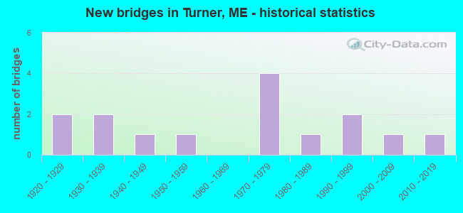
- New bridges - historical statistics
- 21920-1929
- 21930-1939
- 11940-1949
- 11950-1959
- 41970-1979
- 11980-1989
- 21990-1999
- 12000-2009
- 12010-2019
FCC Registered Cell Phone Towers:
2 (See the full list of FCC Registered Cell Phone Towers in Turner)FCC Registered Antenna Towers:
12 (See the full list of FCC Registered Antenna Towers)FCC Registered Broadcast Land Mobile Towers:
6- General Turner Hill Rd Near Jct Rtes 4 & 117 (Lat: 44.261194 Lon: -70.262000), Call Sign: WNAJ939, Licensee ID: L00809500,
Assigned Frequencies: 154.265 MHz, 154.310 MHz, Grant Date: 06/21/2000, Expiration Date: 10/23/2004, Cancellation Date: 10/07/2004, Registrant: Androscoggin County Of Maine, Eoc 2 College Street, Lewiston, ME 04240-7101, Phone: (207) 784-0147, Fax: (207) 784-0149, Email:
- 150 Main Street Old Rt 4 Near Jct Rt 117 (Lat: 44.254528 Lon: -70.252833), Type: Tower, Structure height: 19 m, Overall height: 26 m, Call Sign: KNIQ350,
Assigned Frequencies: 154.115 MHz, 154.115 MHz, Grant Date: 05/25/2023, Expiration Date: 06/01/2033, Registrant: County Of Androscoggin, 2 College Street, Lewiston, ME 04240-7101, Phone: (207) 784-0147, Fax: (207) 795-8938, Email:
- Fire Station General Turner Hill Rd Turner Village (Lat: 44.253694 Lon: -70.255056), Call Sign: KVA757,
Assigned Frequencies: 153.845 MHz, Grant Date: 02/13/2013, Expiration Date: 03/30/2023, Cancellation Date: 06/03/2023, Registrant: Washington Radio Reports, 1588 Fairfield Road Ste 7, Gettsbury, PA 17325, Phone: (717) 334-0668, Fax: (717) 334-6440
- Main St Old Rt 4 Near Jct Rt 117 (Lat: 44.254528 Lon: -70.252833), Type: Tower, Structure height: 17 m, Overall height: 19 m, Call Sign: KNIQ355, Licensee ID: L00809500,
Assigned Frequencies: 154.115 MHz, Grant Date: 07/26/1999, Expiration Date: 07/26/2004, Cancellation Date: 03/05/2005, Certifier: Peter Van Gagnon, Registrant: County Of Androscoggin, 2 College St, Lewiston, ME 04240-7101, Phone: (207) 784-0147, Fax: (207) 784-0149
- Eoc Central Fire Sta General Turner Hill Rd Near Jct Old Rt 4 And 117 (Lat: 44.258139 Lon: -70.255056), Type: Tower, Structure height: 12 m, Overall height: 19 m, Call Sign: WNAJ912,
Assigned Frequencies: 154.265 MHz, 154.310 MHz, Grant Date: 03/16/2015, Expiration Date: 03/09/2025, Certifier: Peter Van Gagnon, Registrant: County Of Androscoggin, 2 College Street, Lewiston, ME 04240-7101, Phone: (207) 784-0147, Fax: (207) 795-8938, Email:
- Lat: 44.315611 Lon: -70.213667, Call Sign: WQXV588,
Assigned Frequencies: 173.350 MHz, Grant Date: 06/21/2016, Expiration Date: 06/21/2026, Certifier: Rodney Guptil, Registrant: Communications Consultant, 11 Alling Dr, Gray, ME 04039, Phone: (207) 831-3708
FCC Registered Microwave Towers:
1- Poplar Hill, 87 Lard Pond Road (Lat: 44.197750 Lon: -70.241472), Type: Mtower, Structure height: 54.6 m, Overall height: 56 m, Call Sign: WQSD603,
Assigned Frequencies: 19475.0 MHz, 19475.0 MHz, 19475.0 MHz, 19475.0 MHz, 19475.0 MHz, 19475.0 MHz, 19475.0 MHz, 19475.0 MHz, 19475.0 MHz, Grant Date: 09/05/2013, Expiration Date: 09/05/2023, Cancellation Date: 09/17/2020, Certifier: Jessica B Lyons, Registrant: At&t Mobility LLC, 208 S. Akard Street, Room 2100, Dallas, TX 75202, Phone: (855) 699-7073, Email:
FCC Registered Amateur Radio Licenses:
28 (See the full list of FCC Registered Amateur Radio Licenses in Turner)FAA Registered Aircraft:
12 (See the full list of FAA Registered Aircraft in Turner)2003 - 2018 National Fire Incident Reporting System (NFIRS) incidents
- Fire incident types reported to NFIRS in Turner, ME
- 19761.4%Structure Fires
- 5818.1%Mobile Property/Vehicle Fires
- 4915.3%Outside Fires
- 175.3%Other
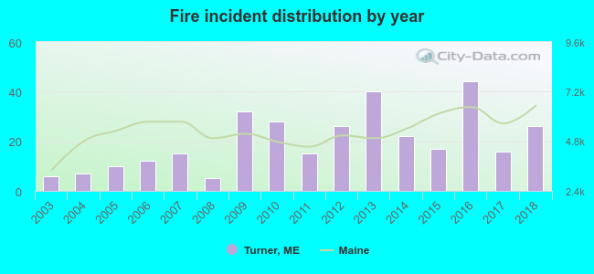 Based on the data from the years 2003 - 2018 the average number of fire incidents per year is 20. The highest number of fires - 44 took place in 2016, and the least - 5 in 2008. The data has a growing trend.
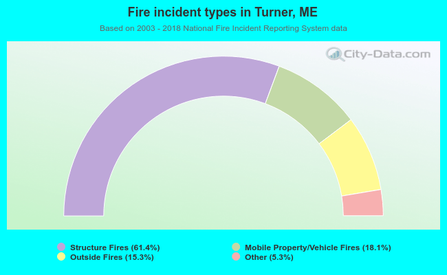 When looking into fire subcategories, the most incidents belonged to: Structure Fires (61.4%), and Mobile Property/Vehicle Fires (18.1%).
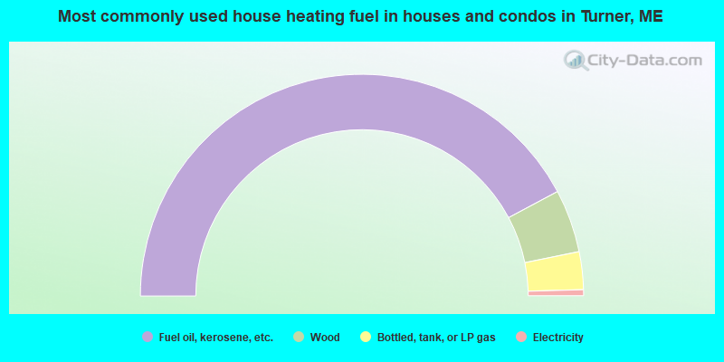
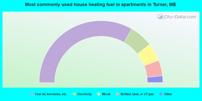
- 84.4%Fuel oil, kerosene, etc.
- 9.2%Wood
- 5.5%Bottled, tank, or LP gas
- 0.9%Electricity
- 66.5%Fuel oil, kerosene, etc.
- 12.3%Electricity
- 9.5%Wood
- 8.2%Bottled, tank, or LP gas
- 1.9%Utility gas
- 1.6%No fuel used
Turner compared to Maine state average:
- Unemployed percentage significantly below state average.
- Black race population percentage significantly below state average.
- Renting percentage below state average.
- Length of stay since moving in significantly above state average.
- Number of rooms per house significantly below state average.
- House age significantly below state average.
Turner on our top lists:
- #7 on the list of "Top 101 cities with largest percentage of males in occupations: other construction workers and helpers (population 5,000+)"
- #10 on the list of "Top 101 cities with largest percentage of males in industries: professional and commercial equipment and supplies merchant wholesalers (population 5,000+)"
- #12 on the list of "Top 101 cities with largest percentage of males in industries: machinery, equipment, and supplies merchant wholesalers (population 5,000+)"
- #13 on the list of "Top 101 cities with largest percentage of males in industries: private households (population 5,000+)"
- #14 on the list of "Top 101 cities with largest percentage of males in industries: leather and allied products (population 5,000+)"
- #14 on the list of "Top 101 cities with largest percentage of males in industries: paper (population 5,000+)"
- #17 on the list of "Top 101 cities with largest percentage of females in industries: paper (population 5,000+)"
- #21 on the list of "Top 101 cities with largest percentage of females in industries: electronic shopping and mail-order houses (population 5,000+)"
- #24 on the list of "Top 101 cities with largest percentage of females in industries: leather and allied products (population 5,000+)"
- #30 on the list of "Top 101 cities with largest percentage of males in industries: beverage and tobacco products (population 5,000+)"
- #39 on the list of "Top 101 cities with largest percentage of males in occupations: printing workers (population 5,000+)"
- #40 on the list of "Top 101 cities with largest percentage of males in occupations: other transportation workers (population 5,000+)"
- #41 on the list of "Top 101 cities with largest percentage of females in occupations: bus drivers (population 5,000+)"
- #49 on the list of "Top 101 cities with largest percentage of males in occupations: plant and system operators (population 5,000+)"
- #52 on the list of "Top 101 cities with largest percentage of males in occupations: special education teachers (population 5,000+)"
- #68 on the list of "Top 101 cities with largest percentage of males in industries: gasoline stations (population 5,000+)"
- #69 on the list of "Top 101 cities with largest percentage of females in industries: printing and related support activities (population 5,000+)"
- #71 on the list of "Top 101 cities with largest percentage of males in industries: miscellaneous nondurable goods merchant wholesalers (population 5,000+)"
- #71 on the list of "Top 101 cities with largest percentage of females in industries: textile mills and textile products (population 5,000+)"
- #74 on the list of "Top 101 cities with largest percentage of males in industries: farm supplies merchant wholesalers (population 5,000+)"
- #21 on the list of "Top 101 counties with the largest increase in the number of births per 1000 residents 2000-2006 to 2007-2013 (pop 50,000+)"
- #55 on the list of "Top 101 counties with the smallest number of children under 18 without health insurance coverage in 2000 (pop. 50,000+)"
- #64 on the list of "Top 101 counties with the smallest number of people without health insurance coverage in 2000 (pop. 50,000+)"
- #73 on the list of "Top 101 counties with highest percentage of residents voting for 3rd party candidates in the 2012 Presidential Election (pop. 50,000+)"

|
|
Total of 9 patent applications in 2008-2024.