Turtletown, Tennessee
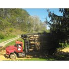
Turtletown: Timber cutting is a trade in Turtletown that support families. I had my timber cut on my property. As a person goes to work a person will need to leave early in order to avoid the log trucks.
- add
your
Submit your own pictures of this place and show them to the world
- OSM Map
- General Map
- Google Map
- MSN Map

| Males: 775 | |
| Females: 780 |
| Median resident age: | 40.8 years |
| Tennessee median age: | 35.9 years |
Zip code: 37333
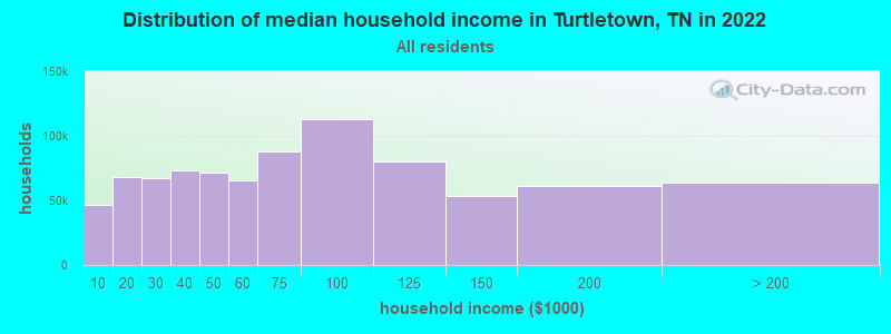
| Turtletown: | $40,261 |
| TN: | $65,254 |
Estimated per capita income in 2022: $28,605 (it was $14,806 in 2000)
Turtletown CCD income, earnings, and wages data
Estimated median house or condo value in 2022: $136,630 (it was $55,500 in 2000)
| Turtletown: | $136,630 |
| TN: | $284,800 |
Detailed information about poverty and poor residents in Turtletown, TN


- 1,55897.8%White alone
- 281.8%Two or more races
- 50.3%American Indian alone
- 20.1%Hispanic
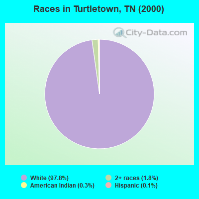
Races in Turtletown detailed stats: ancestries, foreign born residents, place of birth
According to our research of Tennessee and other state lists, there were 4 registered sex offenders living in Turtletown, Tennessee as of May 26, 2024.
The ratio of all residents to sex offenders in Turtletown is 389 to 1.
The ratio of registered sex offenders to all residents in this city is near the state average.
 Recent articles from our blog. Our writers, many of them Ph.D. graduates or candidates, create easy-to-read articles on a wide variety of topics.
Current Local Time: EST time zone
Elevation: 1520 feet
Land area: 54.9 square miles.
Population density: 28 people per square mile (very low).

| Turtletown CCD: | 0.6% ($316) |
| Tennessee: | 0.8% ($715) |
Nearest city with pop. 50,000+: Chattanooga, TN  (52.9 miles , pop. 155,554).
Nearest city with pop. 200,000+: Atlanta, GA (94.9 miles , pop. 416,474).
Nearest city with pop. 1,000,000+: Chicago, IL (498.0 miles , pop. 2,896,016).
Nearest cities:
), ), ), ), Latitude: 35.13 N, Longitude: 84.34 W

| Here: | 3.5% |
| Tennessee: | 3.0% |
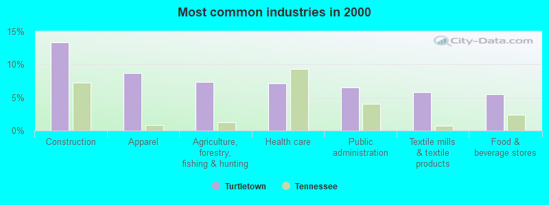
- Construction (13.3%)
- Apparel (8.7%)
- Agriculture, forestry, fishing & hunting (7.3%)
- Health care (7.2%)
- Public administration (6.5%)
- Textile mills & textile products (5.8%)
- Food & beverage stores (5.5%)
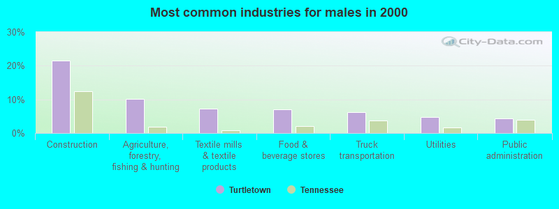
- Construction (21.6%)
- Agriculture, forestry, fishing & hunting (10.2%)
- Textile mills & textile products (7.3%)
- Food & beverage stores (7.0%)
- Truck transportation (6.2%)
- Utilities (4.9%)
- Public administration (4.3%)
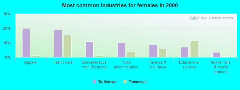
- Apparel (20.1%)
- Health care (18.8%)
- Miscellaneous manufacturing (10.9%)
- Public administration (10.0%)
- Finance & insurance (8.7%)
- Educational services (7.0%)
- Textile mills & textile products (3.5%)

- Textile, apparel, and furnishings workers (14.5%)
- Other sales and related occupations, including supervisors (7.3%)
- Driver/sales workers and truck drivers (7.3%)
- Other office and administrative support workers, including supervisors (6.0%)
- Laborers and material movers, hand (5.3%)
- Supervisors, construction and extraction workers (3.2%)
- Construction traders workers except carpenters, electricians, painters, plumbers, and construction laborers (3.2%)
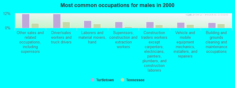
- Other sales and related occupations, including supervisors (11.9%)
- Driver/sales workers and truck drivers (11.9%)
- Laborers and material movers, hand (6.2%)
- Supervisors, construction and extraction workers (5.1%)
- Construction traders workers except carpenters, electricians, painters, plumbers, and construction laborers (5.1%)
- Vehicle and mobile equipment mechanics, installers, and repairers (4.6%)
- Building and grounds cleaning and maintenance occupations (4.3%)
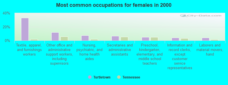
- Textile, apparel, and furnishings workers (33.2%)
- Other office and administrative support workers, including supervisors (11.8%)
- Nursing, psychiatric, and home health aides (7.4%)
- Secretaries and administrative assistants (6.6%)
- Preschool, kindergarten, elementary, and middle school teachers (4.8%)
- Information and record clerks, except customer service representatives (3.9%)
- Laborers and material movers, hand (3.9%)
Average climate in Turtletown, Tennessee
Based on data reported by over 4,000 weather stations


(lower is better)
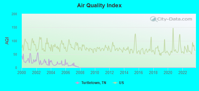
Air Quality Index (AQI) level in 2007 was 6.59. This is significantly better than average.
| City: | 6.59 |
| U.S.: | 72.56 |

Sulfur Dioxide (SO2) [ppb] level in 2007 was 1.61. This is about average. Closest monitor was 7.7 miles away from the city center.
| City: | 1.61 |
| U.S.: | 1.51 |
Tornado activity:
Turtletown-area historical tornado activity is slightly below Tennessee state average. It is 4% greater than the overall U.S. average.
On 4/3/1974, a category F4 (max. wind speeds 207-260 mph) tornado 12.7 miles away from the Turtletown place center killed 4 people and injured 26 people and caused between $5,000,000 and $50,000,000 in damages.
On 4/3/1974, a category F4 tornado 30.7 miles away from the place center killed 9 people and injured 67 people and caused between $500,000 and $5,000,000 in damages.
Earthquake activity:
Turtletown-area historical earthquake activity is significantly above Tennessee state average. It is 83% greater than the overall U.S. average.On 4/29/2003 at 08:59:39, a magnitude 4.9 (4.4 MB, 4.6 MW, 4.9 LG, Class: Light, Intensity: IV - V) earthquake occurred 85.5 miles away from Turtletown center
On 11/30/1973 at 07:48:41, a magnitude 4.7 (4.7 MB, 4.6 ML) earthquake occurred 50.8 miles away from the city center
On 8/2/1974 at 08:52:09, a magnitude 4.9 (4.3 MB, 4.9 LG) earthquake occurred 136.8 miles away from the city center
On 12/12/2018 at 09:14:43, a magnitude 4.4 (4.4 MW, Depth: 4.9 mi) earthquake occurred 40.0 miles away from Turtletown center
On 4/29/2003 at 08:59:39, a magnitude 4.6 (4.6 MW, Depth: 12.3 mi) earthquake occurred 85.6 miles away from the city center
On 7/27/1980 at 18:52:21, a magnitude 5.2 (5.1 MB, 4.7 MS, 5.0 UK, 5.2 UK, Class: Moderate, Intensity: VI - VII) earthquake occurred 213.7 miles away from the city center
Magnitude types: regional Lg-wave magnitude (LG), body-wave magnitude (MB), local magnitude (ML), surface-wave magnitude (MS), moment magnitude (MW)
Natural disasters:
The number of natural disasters in Polk County (17) is near the US average (15).Major Disasters (Presidential) Declared: 12
Emergencies Declared: 2
Causes of natural disasters: Storms: 10, Floods: 9, Tornadoes: 7, Winds: 3, Flash Floods: 2, Winter Storms: 2, Fire: 1, Heavy Rain: 1, Hurricane: 1, Ice Storm: 1, Snowfall: 1, Other: 1 (Note: some incidents may be assigned to more than one category).
Colleges/universities with over 2000 students nearest to Turtletown:
- Lee University (about 31 miles; Cleveland, TN; Full-time enrollment: 4,422)
- Cleveland State Community College (about 31 miles; Cleveland, TN; FT enrollment: 2,500)
- Southern Adventist University (about 41 miles; Collegedale, TN; FT enrollment: 2,898)
- Dalton State College (about 45 miles; Dalton, GA; FT enrollment: 3,846)
- University of North Georgia (about 47 miles; Dahlonega, GA; FT enrollment: 12,445)
- Chattanooga State Community College (about 51 miles; Chattanooga, TN; FT enrollment: 6,827)
- Roane State Community College (about 55 miles; Harriman, TN; FT enrollment: 4,302)
Points of interest:
Notable locations in Turtletown: Mountain Spur (A), The Loop (B), Buck Bald Lookout (C), East Polk County Fire and Rescue Station 2 (D). Display/hide their locations on the map
Churches in Turtletown include: Turtletown Baptist Church (A), Zion Hill Church (B), Croft Chapel (C), Maple Grove Church (D), Mount Carmel Church (E). Display/hide their locations on the map
Cemeteries: Threewit Cemetery (1), Neal Chapel Cemetery (2), Butler Cemetery (3), Brock Cemetery (4), Spurling Cemetery (5). Display/hide their locations on the map
Streams, rivers, and creeks: Negro Creek (A), Turtletown Creek (B), Watertank Branch (C), West Fork Butler Branch (D), West Fork Hiwassee River (E), Wolf Creek (F), Womble Branch (G), Bear Branch (H), Jenkins Grave Branch (I). Display/hide their locations on the map
Drinking water stations with addresses in Turtletown and their reported violations in the past:
COPPER BASIN UTILITY DISTRICT (Population served: 2,710, Surface water):Past monitoring violations:
- Monitoring and Reporting (DBP) - Between APR-2011 and JUN-2011, Contaminant: Chlorine. Follow-up actions: St Public Notif requested (AUG-08-2011), St Violation/Reminder Notice (AUG-08-2011), St Compliance achieved (2 times from SEP-30-2011 to JUN-15-2012)
- Monitoring, Repeat Major (TCR) - In OCT-2009, Contaminant: Coliform (TCR). Follow-up actions: St Compliance achieved (NOV-30-2009), St Public Notif requested (DEC-01-2009), St Violation/Reminder Notice (DEC-01-2009)
- Monitoring, Routine (IDSE) - Between APR-2009 and JUN-2009, Contaminant: Total Haloacetic Acids (HAA5). Follow-up actions: St Compliance achieved (AUG-12-2009), St Public Notif requested (AUG-24-2009), St Violation/Reminder Notice (AUG-24-2009), St Public Notif received (MAY-15-2010)
- Monitoring, Routine (IDSE) - Between APR-2009 and JUN-2009, Contaminant: TTHM. Follow-up actions: St Compliance achieved (AUG-12-2009), St Public Notif requested (AUG-24-2009), St Violation/Reminder Notice (AUG-24-2009), St Public Notif received (MAY-15-2010)
- Monitoring and Reporting (DBP) - Between APR-2008 and JUN-2008, Contaminant: CARBON, TOTAL. Follow-up actions: St Violation/Reminder Notice (JUL-31-2008), St Public Notif requested (JUL-31-2008), St Compliance achieved (SEP-30-2008)
- One routine major monitoring violation
| This place: | 2.4 people |
| Tennessee: | 2.5 people |
| This place: | 63.1% |
| Whole state: | 69.8% |
| This place: | 2.6% |
| Whole state: | 4.2% |
Likely homosexual households (counted as self-reported same-sex unmarried-partner households)
- Lesbian couples: 0.2% of all households
- Gay men: 0.0% of all households
| This place: | 18.6% |
| Whole state: | 13.5% |
| This place: | 9.2% |
| Whole state: | 5.8% |
For population 15 years and over in Turtletown:
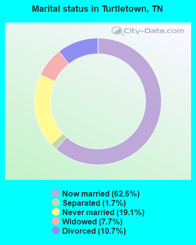
- Never married: 19.1%
- Now married: 62.5%
- Separated: 1.7%
- Widowed: 7.7%
- Divorced: 10.7%
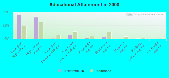
For population 25 years and over in Turtletown:
- High school or higher: 54.2%
- Bachelor's degree or higher: 4.1%
- Graduate or professional degree: 0.5%
- Unemployed: 3.8%
- Mean travel time to work (commute): 31.2 minutes
| Here: | 17.3 |
| Tennessee average: | 13.3 |
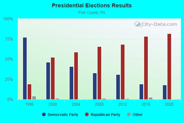
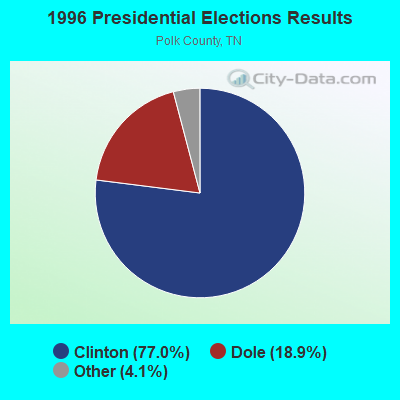
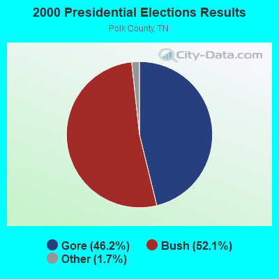


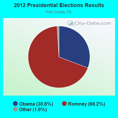


Graphs represent county-level data. Detailed 2008 Election Results
Religion statistics for Turtletown, TN (based on Polk County data)
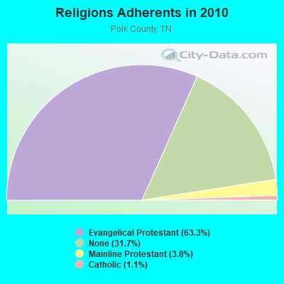
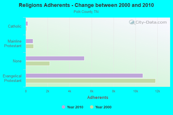
| Religion | Adherents | Congregations |
|---|---|---|
| Evangelical Protestant | 10,658 | 53 |
| Mainline Protestant | 644 | 5 |
| Catholic | 190 | 1 |
| Other | - | 1 |
| None | 5,333 | - |
Food Environment Statistics:
| This county: | 1.28 / 10,000 pop. |
| State: | 1.99 / 10,000 pop. |
| Here: | 7.68 / 10,000 pop. |
| Tennessee: | 5.16 / 10,000 pop. |
| Polk County: | 5.12 / 10,000 pop. |
| State: | 6.56 / 10,000 pop. |
| Here: | 12.7% |
| Tennessee: | 11.4% |
| Polk County: | 31.3% |
| Tennessee: | 30.2% |
| Polk County: | 15.1% |
| Tennessee: | 13.5% |
Strongest AM radio stations in Turtletown:
- WFLI (1070 AM; 50 kW; LOOKOUT MOUNTAIN, TN; Owner: WFLI, INC.)
- WKVL (850 AM; daytime; 50 kW; KNOXVILLE, TN; Owner: HORNE RADIO, LLC)
- WWAM (820 AM; daytime; 50 kW; JASPER, TN; Owner: SHELTON BROADCASTING SYSTEM)
- WKRK (1320 AM; 5 kW; MURPHY, NC; Owner: RADFORD COMMUNICATIONS, INC.)
- WCNN (680 AM; 50 kW; NORTH ATLANTA, GA; Owner: DICKEY BROADCASTING COMPANY)
- WGST (640 AM; 50 kW; ATLANTA, GA; Owner: CITICASTERS LICENSES, L.P.)
- WSB (750 AM; 50 kW; ATLANTA, GA; Owner: CXR HOLDINGS, INC.)
- WFTD (1080 AM; daytime; 50 kW; MARIETTA, GA; Owner: PRIETO ENTERPRISES, INC.)
- WLFJ (660 AM; daytime; 50 kW; GREENVILLE, SC; Owner: CLEAR CHANNEL BROADCASTING LICENSES, INC.)
- WMLB (1160 AM; 50 kW; EAST POINT, GA; Owner: ATLANTA AREA BROADCASTING, INC.)
- WGUN (1010 AM; 50 kW; ATLANTA, GA; Owner: WGUN, INC.)
- WAZX (1550 AM; 50 kW; SMYRNA, GA; Owner: GA-MEX BROADCASTING, INC.)
- WDUN (550 AM; 10 kW; GAINESVILLE, GA; Owner: JWJ PROPERTIRS, INC.)
Strongest FM radio stations in Turtletown:
- WCVP-FM (95.9 FM; ROBBINSVILLE, NC; Owner: CHEROKEE BROADCASTING COMPANY, INC.)
- WFQS (91.3 FM; FRANKLIN, NC; Owner: WESTERN NORTH CAROLINA PUBLIC RADIO)
- W234AG (94.7 FM; CHATSWORTH, GA; Owner: IMMANUEL BROADCASTING NETWORK, INC.)
- WLLJ (103.1 FM; ETOWAH, TN; Owner: FRIENDSHIP BROADCASTING LLC.)
- WCNG (102.7 FM; MURPHY, NC; Owner: CHEROKEE BROADCASTING CO., INC.)
- WIVK-FM (107.7 FM; KNOXVILLE, TN; Owner: CITADEL BROADCASTING COMPANY)
- WWST (102.1 FM; SEVIERVILLE, TN; Owner: JOURNAL BROADCAST CORPORATION)
- WOKI-FM (100.3 FM; OAK RIDGE, TN; Owner: OAK RIDGE FM, INC.)
- WUSY (100.7 FM; CLEVELAND, TN; Owner: CAPSTAR TX LIMITED PARTNERSHIP)
- WPPL (103.9 FM; BLUE RIDGE, GA; Owner: FANNIN COUNTY BROADCASTING CO., INC.)
- WYGO (99.5 FM; MADISONVILLE, TN; Owner: MAJOR BROADCASTING CORPORATION)
- WQMT (98.9 FM; CHATSWORTH, GA; Owner: CLEAR CHANNEL BROADCASTING LICENSES, INC.)
- WJSQ (101.7 FM; ATHENS, TN; Owner: JAMES C. SLIGER)
- WALV (95.3 FM; CLEVELAND, TN; Owner: J. L. BREWER BROADCASTING OF CLEVELAND, LLC)
- WCLE-FM (104.1 FM; CALHOUN, TN; Owner: WILLIAMS COMMUNICATIONS, INC.)
- WNSY (100.1 FM; TALKING ROCK, GA; Owner: CHARLES A. MCCLURE)
- WLOD-FM (98.3 FM; SWEETWATER, TN; Owner: HORNE RADIO, LLC)
- WOCE (93.1 FM; BENTON, TN; Owner: LB RADIO OF CHATTANOOGA, LLC)
- W250AJ (97.9 FM; COPPERHILL, TN; Owner: JOHN REYNOLDS)
TV broadcast stations around Turtletown:
- W50AB (Channel 50; HIAWASSEE, GA; Owner: GEORGIA PUBLIC TELECOMMUNICATIONS COMMISSION)
- WFLI-TV (Channel 53; CLEVELAND, TN; Owner: CHATTANOOGA MEDIA HOLDINGS, L.L.C.)
- WDTT-LP (Channel 38; LENOIR CITY, TN; Owner: WORD OF GOD FELLOWSHIP, INC.)
- WPDP-LP (Channel 25; CLEVELAND, TN; Owner: WDSI LICENSE CORP.)
FCC Registered Antenna Towers:
2- Carolyn Key, 133 Lake Lamar Rd (Us-Tn-5288) (Lat: 35.080333 Lon: -84.382806), Type: 94.4, Structure height: 47139 m, Overall height: 91.4 m, Registrant: Vb Bts Ii, LLC, Fcc-Faa@verticalbridge.Com, , Boca -Raton, Phone: (561) 406-4015
- Julie Heffernan, 133 Lake Lamar Rd (Us-Tn-5288) (Lat: 35.080333 Lon: -84.382806), Type: 94.4, Structure height: 47139 m, Overall height: 91.4 m, Registrant: Vb Bts Ii, LLC, Fcc-Faa@verticalbridge.Com, , Boca -Raton, Phone: (561) 406-4015
FCC Registered Broadcast Land Mobile Towers:
2- 701 Ducks Nest Road (Lat: 35.067056 Lon: -84.392278), Type: Pole, Structure height: 7 m, Overall height: 13 m, Call Sign: WRYU953,
Assigned Frequencies: 154.860 MHz, Grant Date: 09/20/2023, Expiration Date: 03/18/2024, Certifier: Was Davis, Registrant: Apco International Inc, 351 N Williamson Blvd, Daytona Beach, FL 32114, Phone: (386) 944-2469, Email:
- 701 Ducks Nest Road (Lat: 35.067056 Lon: -84.392278), Type: Pole, Structure height: 7 m, Overall height: 13 m, Call Sign: WRZC694,
Assigned Frequencies: 154.860 MHz, Grant Date: 10/17/2023, Expiration Date: 10/17/2033, Cancellation Date: 10/17/2023, Certifier: Wes Davis, Registrant: Apco International Inc, 351 N Williamson Blvd, Daytona Beach, FL 32114, Phone: (386) 944-2469, Email:
FCC Registered Amateur Radio Licenses:
6- Call Sign: KA6USA, Previous Call Sign: KK6NE, Licensee ID: L01296567, Grant Date: 06/26/2007, Expiration Date: 09/17/2017, Cancellation Date: 05/14/2010, Registrant: Charles R Pharis, 459 Padgett Lane, Turtletown, TN 37391
- Call Sign: KD4OPO, Grant Date: 12/01/1992, Expiration Date: 12/01/2002, Cancellation Date: 12/02/2004, Registrant: Wayne E Hall, Rt 1 Box 1114, Turtletown, TN 37391
- Call Sign: KG4DPA, Licensee ID: L00275482, Grant Date: 06/18/2019, Expiration Date: 06/18/2029, Registrant: Matthew D Deal, 1125 Kimsey Dairy Rd, Turtletown, TN 37317
- Call Sign: KG4ZQS, Licensee ID: L00670580, Grant Date: 08/11/2023, Expiration Date: 08/11/2033, Certifier: Steven D Allen, Registrant: Steven D Allen, 1854 Kimsey Dairy Rd., Turtletown, TN 37391
- Call Sign: KJ4PAC, Licensee ID: L01518492, Grant Date: 08/14/2019, Expiration Date: 09/16/2029, Certifier: Florence E Tichenor, Registrant: Florence E Tichenor, 305 Campbell Cove Rd, Turtletown, TN 37391
- Call Sign: KM4ZFG, Licensee ID: L02065399, Grant Date: 11/22/2016, Expiration Date: 11/22/2026, Certifier: Michael G Turner, Registrant: Michael G Turner, 157 Beaver Cove Rd, Turtletown, TN 37391
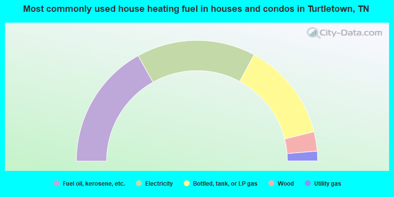
- 33.8%Fuel oil, kerosene, etc.
- 31.9%Electricity
- 26.5%Bottled, tank, or LP gas
- 5.2%Wood
- 2.6%Utility gas
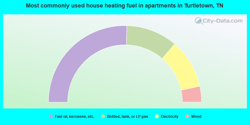
- 50.8%Fuel oil, kerosene, etc.
- 21.7%Bottled, tank, or LP gas
- 20.8%Electricity
- 6.7%Wood
Turtletown compared to Tennessee state average:
- Median household income below state average.
- Median house value below state average.
- Unemployed percentage significantly below state average.
- Black race population percentage significantly below state average.
- Hispanic race population percentage significantly below state average.
- Foreign-born population percentage significantly below state average.
- Renting percentage significantly below state average.
- Length of stay since moving in significantly above state average.
- Number of rooms per house significantly below state average.
- House age significantly below state average.
- Number of college students below state average.
- Percentage of population with a bachelor's degree or higher significantly below state average.

|
Total of 2 patent applications in 2008-2024.