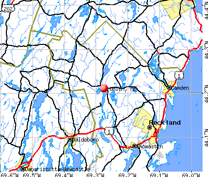
Union, Maine

Union: Herb's Garden

Union: Round Pond

Union: Hawes Road

Union: Historic Street Signs of Union, Maine

Union: sunrise, union me
- add
your
Submit your own pictures of this town and show them to the world
- OSM Map
- General Map
- Google Map
- MSN Map
Population change since 2000: +2.3%
 |
| Males: 1,108 | |
| Females: 1,151 |
| Median resident age: | 46.5 years |
| Maine median age: | 43.0 years |
Zip codes: 04862.
| Union: | $71,936 |
| ME: | $69,543 |
Estimated per capita income in 2022: $33,191 (it was $16,240 in 2000)
Union town income, earnings, and wages data
Estimated median house or condo value in 2022: $271,667 (it was $96,700 in 2000)
| Union: | $271,667 |
| ME: | $290,600 |
Detailed information about poverty and poor residents in Union, ME


- 2,22198.3%White alone
- 120.5%Two or more races
- 90.4%American Indian alone
- 100.4%Hispanic
- 60.3%Black alone
- 10.04%Asian alone
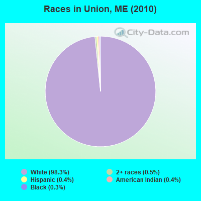
Races in Union detailed stats: ancestries, foreign born residents, place of birth
According to our research of Maine and other state lists, there were 5 registered sex offenders living in Union, Maine as of May 18, 2024.
The ratio of all residents to sex offenders in Union is 452 to 1.
The ratio of registered sex offenders to all residents in this city is near the state average.
 Recent articles from our blog. Our writers, many of them Ph.D. graduates or candidates, create easy-to-read articles on a wide variety of topics.

 | 3bd 2ba house on Union st in Bangor asking $49,900 (1 reply) |
| Current Lobster prices (71 replies) |
| Common Ground fair 2022 (15 replies) |
| I love the Maine Coast, but here is the reality... (43 replies) |
| Days after minimum wage rises, Maine diner near nh cuts staff hours. (292 replies) |
| Moving to Maine (possibly Bangor) need advice (32 replies) |
Latest news from Union, ME collected exclusively by city-data.com from local newspapers, TV, and radio stations
Ancestries: English (23.6%), Irish (13.9%), German (10.8%), United States (8.6%), French (7.4%), Scottish (5.3%).
Current Local Time: EST time zone
Incorporated on 10/20/1786
Elevation: 97 feet
Land area: 32.1 square miles.
Population density: 70 people per square mile (very low).
48 residents are foreign born (1.4% Europe, 0.5% North America, 0.2% Latin America).
| This town: | 2.2% |
| Maine: | 2.9% |
| Union town: | 1.3% ($1,223) |
| Maine: | 1.5% ($1,417) |
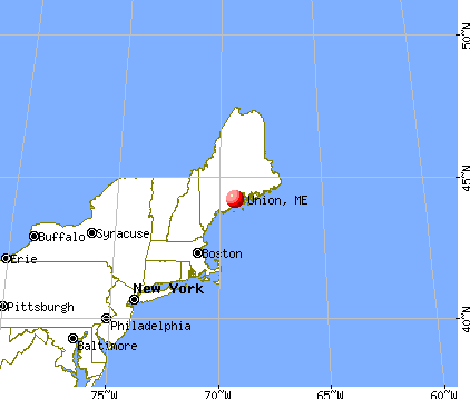
Nearest city with pop. 50,000+: Portland, ME  (62.6 miles , pop. 64,249).
Nearest city with pop. 200,000+: Boston, MA (159.8 miles , pop. 589,141).
Nearest city with pop. 1,000,000+: Bronx, NY (330.5 miles , pop. 1,332,650).
Nearest cities:
), ), Latitude: 44.21 N, Longitude: 69.27 W
Area code: 207


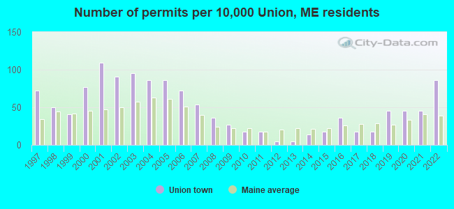
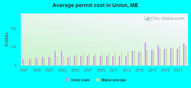
Single-family new house construction building permits:
- 2022: 19 buildings, average cost: $301,400
- 2021: 10 buildings, average cost: $231,400
- 2020: 10 buildings, average cost: $235,500
- 2019: 10 buildings, average cost: $225,500
- 2018: 4 buildings, average cost: $273,800
- 2017: 4 buildings, average cost: $217,500
- 2016: 8 buildings, average cost: $313,500
- 2015: 4 buildings, average cost: $187,500
- 2014: 3 buildings, average cost: $202,500
- 2013: 1 building, cost: $131,500
- 2012: 1 building, cost: $131,500
- 2011: 4 buildings, average cost: $131,500
- 2010: 4 buildings, average cost: $131,500
- 2009: 6 buildings, average cost: $131,500
- 2008: 8 buildings, average cost: $131,400
- 2007: 12 buildings, average cost: $131,500
- 2006: 16 buildings, average cost: $131,000
- 2005: 19 buildings, average cost: $134,200
- 2004: 19 buildings, average cost: $116,700
- 2003: 21 buildings, average cost: $200,000
- 2002: 20 buildings, average cost: $200,000
- 2001: 24 buildings, average cost: $121,400
- 2000: 17 buildings, average cost: $118,000
- 1999: 9 buildings, average cost: $109,200
- 1998: 11 buildings, average cost: $96,000
- 1997: 16 buildings, average cost: $91,700
| Here: | 3.2% |
| Maine: | 3.4% |
- Health care (10.2%)
- Construction (9.2%)
- Finance & insurance (8.5%)
- Educational services (8.1%)
- Agriculture, forestry, fishing & hunting (5.9%)
- Accommodation & food services (5.6%)
- Food & beverage stores (5.0%)
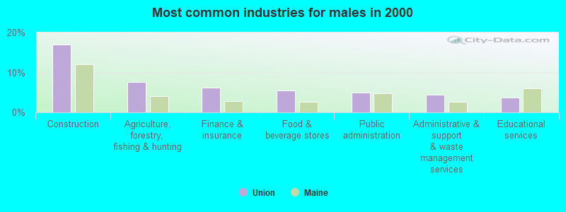
- Construction (16.9%)
- Agriculture, forestry, fishing & hunting (7.7%)
- Finance & insurance (6.2%)
- Food & beverage stores (5.5%)
- Public administration (5.0%)
- Administrative & support & waste management services (4.4%)
- Educational services (3.8%)
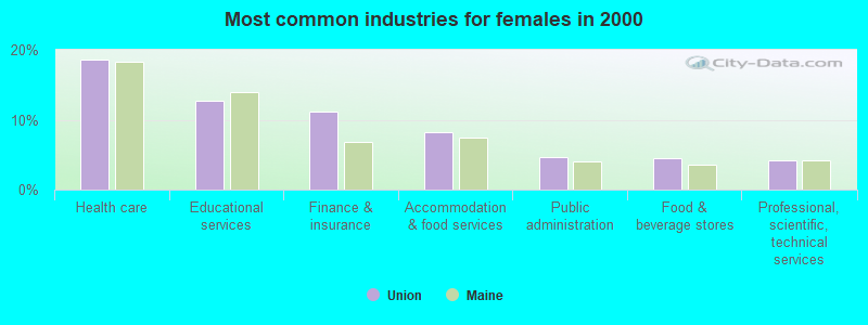
- Health care (18.6%)
- Educational services (12.8%)
- Finance & insurance (11.1%)
- Accommodation & food services (8.3%)
- Public administration (4.7%)
- Food & beverage stores (4.5%)
- Professional, scientific, technical services (4.1%)
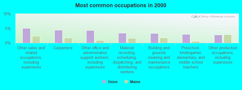
- Other sales and related occupations, including supervisors (5.1%)
- Carpenters (4.4%)
- Other office and administrative support workers, including supervisors (4.3%)
- Material recording, scheduling, dispatching, and distributing workers (3.4%)
- Building and grounds cleaning and maintenance occupations (3.3%)
- Preschool, kindergarten, elementary, and middle school teachers (3.0%)
- Other production occupations, including supervisors (2.8%)
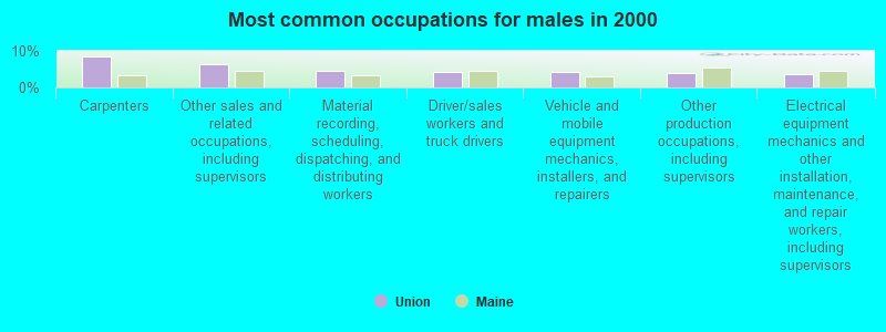
- Carpenters (8.4%)
- Other sales and related occupations, including supervisors (6.5%)
- Material recording, scheduling, dispatching, and distributing workers (4.4%)
- Driver/sales workers and truck drivers (4.3%)
- Vehicle and mobile equipment mechanics, installers, and repairers (4.3%)
- Other production occupations, including supervisors (3.9%)
- Electrical equipment mechanics and other installation, maintenance, and repair workers, including supervisors (3.6%)
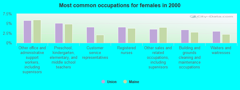
- Other office and administrative support workers, including supervisors (5.8%)
- Preschool, kindergarten, elementary, and middle school teachers (5.1%)
- Customer service representatives (4.1%)
- Registered nurses (4.1%)
- Other sales and related occupations, including supervisors (3.6%)
- Building and grounds cleaning and maintenance occupations (3.4%)
- Waiters and waitresses (3.0%)
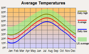
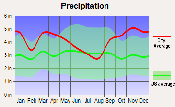
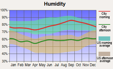
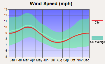
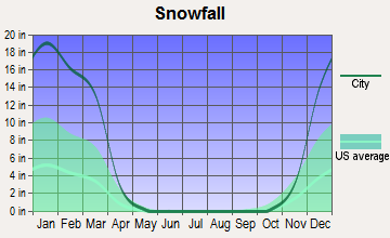
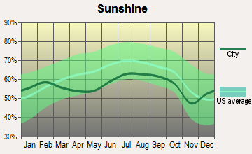
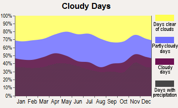
Average climate in Union, Maine
Based on data reported by over 4,000 weather stations
Earthquake activity:
Union-area historical earthquake activity is significantly above Maine state average. It is 78% smaller than the overall U.S. average.On 10/16/2012 at 23:12:25, a magnitude 4.7 (4.7 ML, Depth: 10.0 mi, Class: Light, Intensity: IV - V) earthquake occurred 81.2 miles away from the city center
On 4/20/2002 at 10:50:47, a magnitude 5.3 (5.3 ML, Depth: 3.0 mi, Class: Moderate, Intensity: VI - VII) earthquake occurred 220.0 miles away from Union center
On 4/20/2002 at 10:50:47, a magnitude 5.2 (5.2 MB, 4.2 MS, 5.2 MW, 5.0 MW) earthquake occurred 220.9 miles away from Union center
On 1/19/1982 at 00:14:42, a magnitude 4.7 (4.5 MB, 4.7 MD, 4.5 LG) earthquake occurred 126.3 miles away from Union center
On 10/7/1983 at 10:18:46, a magnitude 5.3 (5.1 MB, 5.3 LG, 5.1 ML) earthquake occurred 252.7 miles away from Union center
On 2/26/1999 at 03:38:43, a magnitude 3.8 (3.8 LG, Depth: 2.0 mi, Class: Light, Intensity: II - III) earthquake occurred 22.3 miles away from Union center
Magnitude types: regional Lg-wave magnitude (LG), body-wave magnitude (MB), duration magnitude (MD), local magnitude (ML), surface-wave magnitude (MS), moment magnitude (MW)
Natural disasters:
The number of natural disasters in Knox County (23) is greater than the US average (15).Major Disasters (Presidential) Declared: 18
Emergencies Declared: 4
Causes of natural disasters: Floods: 16, Storms: 12, Winter Storms: 4, Snows: 3, Hurricanes: 2, Blizzard: 1, Heavy Rain: 1, Ice Storm: 1, Landslide: 1, Mudslide: 1, Snowfall: 1, Wind: 1, Other: 1 (Note: some incidents may be assigned to more than one category).
Hospitals and medical centers near Union:
- FIELDCREST MANOR (Nursing Home, about 10 miles away; WALDOBORO, ME)
- WINDWARD GARDENS (Nursing Home, about 10 miles away; CAMDEN, ME)
- CAMDEN COMM HOSP HC CENTR (Nursing Home, about 10 miles away; CAMDEN, ME)
- SHORE VILLAGE REHAB AND NURSING (Nursing Home, about 11 miles away; ROCKLAND, ME)
- KNO-WAL-LIN HOMECARE AND HOSPICE (Home Health Center, about 11 miles away; ROCKLAND, ME)
- KNOX CENTER FOR LONG TERM CARE (Nursing Home, about 11 miles away; ROCKLAND, ME)
- KNOX CENTER FOR LTC (Nursing Home, about 11 miles away; ROCKLAND, ME)
Colleges/universities with over 2000 students nearest to Union:
- University of Maine at Augusta (about 28 miles; Augusta, ME; Full-time enrollment: 3,204)
- Husson University (about 49 miles; Bangor, ME; FT enrollment: 2,421)
- University of Maine at Farmington (about 54 miles; Farmington, ME; FT enrollment: 2,036)
- University of Maine (about 56 miles; Orono, ME; FT enrollment: 8,931)
- Southern Maine Community College (about 62 miles; South Portland, ME; FT enrollment: 4,666)
- University of Southern Maine (about 64 miles; Portland, ME; FT enrollment: 6,647)
- Saint Joseph's College of Maine (about 67 miles; Standish, ME; FT enrollment: 2,010)
Points of interest:
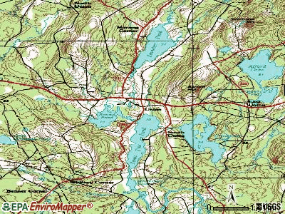
Notable locations in Union: Camp Adahi (A), Union Fairgrounds (B), Union Fire Department (C), Sterling Ambulance (D), Union Ambulance Service (E), Matthews Museum of Maine Heritage (F), Vose Library (G). Display/hide their locations on the map
Cemeteries: Village Cemetery (1), Lake View Cemetery (2), Skidmore Cemetery (3). Display/hide their locations on the map
Lakes and reservoirs: Crawford Pond (A), Round Pond (B), Sennebec Pond (C), Seven Tree Pond (D), Lerman Pond (E), Mill Stream (F). Display/hide their locations on the map
Tourist attraction: Maine Outdoors (Tours & Charters; 69 Beote Road) (1). Display/hide its approximate location on the map
Drinking water stations with addresses in Union and their reported violations in the past:
MSAD 40 MEDOMAK VALLEY HI SCH (Population served: 791, Groundwater):Past health violations:MSAD 40 UNION ELEM-MIDDLE SCH (Population served: 424, Groundwater):Past monitoring violations:
- MCL, Monthly (TCR) - In AUG-2006, Contaminant: Coliform. Follow-up actions: St Public Notif requested (AUG-25-2006), St Violation/Reminder Notice (AUG-25-2006), St Public Notif received (SEP-06-2006), St Compliance achieved (AUG-21-2008)
- Follow-up Or Routine LCR Tap M/R - In JAN-01-2005, Contaminant: Lead and Copper Rule. Follow-up actions: St Compliance achieved (AUG-07-2008)
- 13 regular monitoring violations
Past health violations:MSAD 40 MEDOMAK MIDDLE SCHOOL (Population served: 319, Groundwater):Past monitoring violations:
- MCL, Acute (TCR) - In AUG-2006, Contaminant: Coliform. Follow-up actions: St Tech Assistance Visit (AUG-25-2006), St Violation/Reminder Notice (AUG-25-2006), St Public Notif requested (AUG-25-2006), St Boil Water Order (AUG-25-2006), St Public Notif received (2 times from SEP-06-2006 to SEP-11-2006), St Compliance achieved (SEP-06-2011), St Intentional no-action (SEP-09-2011)
- Follow-up Or Routine LCR Tap M/R - In JAN-01-2005, Contaminant: Lead and Copper Rule. Follow-up actions: St Public Notif requested (AUG-21-2008), St Formal NOV issued (AUG-21-2008), St Intentional no-action (JUL-26-2011), St Compliance achieved (AUG-22-2011)
- 3 routine major monitoring violations
Past monitoring violations:MIC MAC COVE CAMPGROUND, INC (Population served: 207, Groundwater):
- Monitoring and Reporting (DBP) - Between JAN-2011 and DEC-2013, Contaminant: Total Haloacetic Acids (HAA5). Follow-up actions: St Formal NOV issued (NOV-08-2012), St Public Notif requested (NOV-08-2012), St Public Notif received (NOV-19-2012), St Compliance achieved (JUL-15-2013)
- Monitoring and Reporting (DBP) - Between JAN-2011 and DEC-2013, Contaminant: TTHM. Follow-up actions: St Formal NOV issued (NOV-08-2012), St Public Notif requested (NOV-08-2012), St Public Notif received (NOV-19-2012), St Compliance achieved (JUL-15-2013)
- One regular monitoring violation
Past health violations:MSAD 40 PRESCOTT MEM SCHOOL (Population served: 130, Groundwater):Past monitoring violations:
- MCL, Monthly (TCR) - In MAY-2005, Contaminant: Coliform. Follow-up actions: St Public Notif requested (MAY-11-2005), St Violation/Reminder Notice (MAY-11-2005), St Public Notif received (2 times from JUN-10-2005 to JUN-10-2005), St Compliance achieved (APR-17-2007)
- 4 routine major monitoring violations
Past monitoring violations:CRAWFORD COMMONS (Population served: 37, Groundwater):
- Follow-up Or Routine LCR Tap M/R - In JAN-01-2005, Contaminant: Lead and Copper Rule. Follow-up actions: St Public Notif requested (AUG-21-2008), St Formal NOV issued (AUG-21-2008), St Compliance achieved (SEP-05-2008), St Intentional no-action (JUL-26-2011)
Past health violations:Past monitoring violations:
- MCL, Monthly (TCR) - In MAY-2013, Contaminant: Coliform. Follow-up actions: St Public Notif requested (MAY-29-2013), St Formal NOV issued (MAY-29-2013), St Compliance achieved (JUN-20-2013), St Public Notif received (JUN-24-2013)
- MCL, Monthly (TCR) - In APR-2013, Contaminant: Coliform. Follow-up actions: St Public Notif requested (MAY-03-2013), St Formal NOV issued (MAY-03-2013), St Public Notif received (MAY-29-2013), St Compliance achieved (JUN-20-2013)
- MCL, Monthly (TCR) - In MAR-2013, Contaminant: Coliform. Follow-up actions: St Public Notif requested (MAR-27-2013), St Formal NOV issued (MAR-27-2013), St Public Notif received (APR-17-2013), St Compliance achieved (JUN-20-2013)
- MCL, Monthly (TCR) - In OCT-2012, Contaminant: Coliform. Follow-up actions: St Public Notif requested (OCT-24-2012), St Formal NOV issued (OCT-24-2012), St Compliance achieved (NOV-29-2012), St Public Notif received (DEC-07-2012)
- MCL, Monthly (TCR) - In SEP-2012, Contaminant: Coliform. Follow-up actions: St Public Notif requested (SEP-24-2012), St Formal NOV issued (SEP-24-2012), St Public Notif received (OCT-17-2012), St Compliance achieved (NOV-29-2012)
- MCL, Monthly (TCR) - In MAY-2009, Contaminant: Coliform. Follow-up actions: St Public Notif requested (MAY-22-2009), St Formal NOV issued (MAY-22-2009), St Public Notif received (JUN-09-2009), St Compliance achieved (SEP-08-2011), St Intentional no-action (SEP-09-2011)
- Follow-up Or Routine LCR Tap M/R - In OCT-01-2008, Contaminant: Lead and Copper Rule. Follow-up actions: St Public Notif requested (NOV-18-2008), St Formal NOV issued (NOV-18-2008), St Public Notif received (OCT-28-2009), St Compliance achieved (OCT-29-2009)
Drinking water stations with addresses in Union that have no violations reported:
- THOMPSON COMMUNITY CTR/TOWN OF UNION (Population served: 25, Primary Water Source Type: Groundwater)
| This town: | 2.3 people |
| Maine: | 2.3 people |
| This town: | 65.0% |
| Whole state: | 62.9% |
| This town: | 9.5% |
| Whole state: | 9.4% |
Likely homosexual households (counted as self-reported same-sex unmarried-partner households)
- Lesbian couples: 0.6% of all households
- Gay men: 0.3% of all households
| This town: | 9.6% |
| Whole state: | 10.9% |
| This town: | 5.0% |
| Whole state: | 4.1% |
Banks with branches in Union (2011 data):
- Damariscotta Bank & Trust Co.: Union Branch at 17 Sennebec Road, branch established on 2001/08/01. Info updated 2007/04/24: Bank assets: $161.0 mil, Deposits: $142.6 mil, headquarters in Damariscotta, ME, positive income, Commercial Lending Specialization, 6 total offices, Holding Company: Damariscotta Bankshares, Inc.
- The Camden National Bank: Union Branch at Union Common, branch established on 1960/12/19. Info updated 2008/02/27: Bank assets: $2,266.8 mil, Deposits: $1,604.6 mil, headquarters in Camden, ME, positive income, Commercial Lending Specialization, 39 total offices, Holding Company: Camden National Corporation
For population 15 years and over in Union:
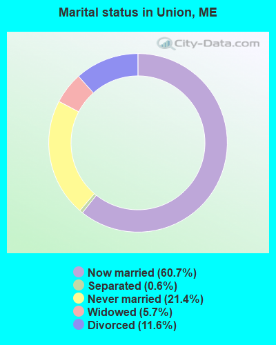
- Never married: 21.4%
- Now married: 60.7%
- Separated: 0.6%
- Widowed: 5.7%
- Divorced: 11.6%
For population 25 years and over in Union:
- High school or higher: 88.8%
- Bachelor's degree or higher: 20.7%
- Graduate or professional degree: 6.0%
- Unemployed: 4.5%
- Mean travel time to work (commute): 26.4 minutes

| Here: | 9.7 |
| Maine average: | 11.2 |
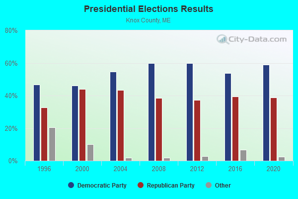
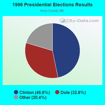
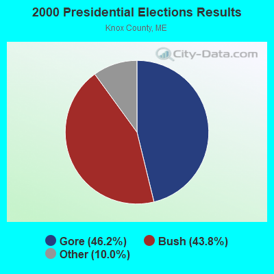
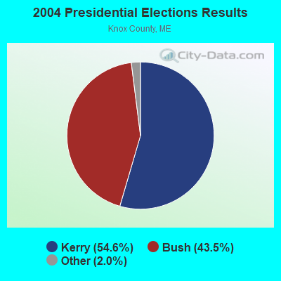

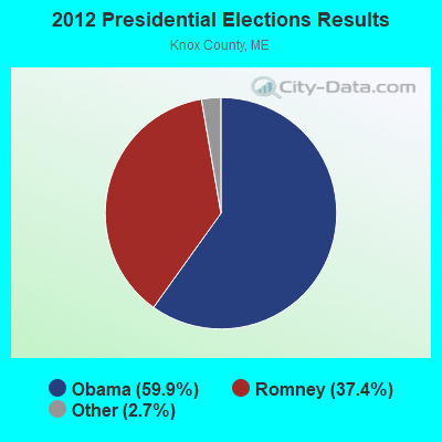
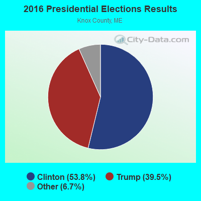
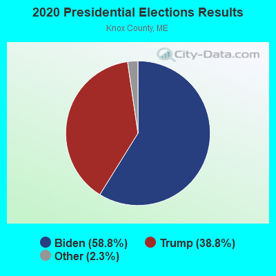
Graphs represent county-level data. Detailed 2008 Election Results
Religion statistics for Union, ME (based on Knox County data)
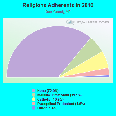
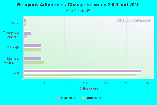
| Religion | Adherents | Congregations |
|---|---|---|
| Mainline Protestant | 4,400 | 29 |
| Catholic | 4,340 | 4 |
| Evangelical Protestant | 1,813 | 23 |
| Other | 569 | 6 |
| None | 28,614 | - |
Food Environment Statistics:
| Knox County: | 4.17 / 10,000 pop. |
| State: | 2.80 / 10,000 pop. |
| Knox County: | 2.21 / 10,000 pop. |
| Maine: | 2.20 / 10,000 pop. |
| Knox County: | 7.37 / 10,000 pop. |
| State: | 5.75 / 10,000 pop. |
| Knox County: | 19.40 / 10,000 pop. |
| State: | 11.02 / 10,000 pop. |
| Knox County: | 7.8% |
| Maine: | 8.2% |
| This county: | 21.6% |
| Maine: | 25.0% |
Businesses in Union, ME
- True Value: 1
Strongest AM radio stations in Union:
- WRKD (1450 AM; 1 kW; ROCKLAND, ME; Owner: CLEAR CHANNEL BROADCASTING LICENSES, INC.)
- WFAU (1280 AM; 5 kW; GARDINER, ME; Owner: CAPSTAR TX LIMITED PARTNERSHIP)
- WSKW (1160 AM; 10 kW; SKOWHEGAN, ME; Owner: MOUNTAIN WIRELESS, INCORPORATED)
- WZON (620 AM; 5 kW; BANGOR, ME; Owner: THE ZONE CORPORATION)
- WRKO (680 AM; 50 kW; BOSTON, MA; Owner: ENTERCOM BOSTON LICENSE, LLC)
- WTME (780 AM; 10 kW; RUMFORD, ME; Owner: MOUNTAIN VALLEY BROADCASTING, INC.)
- WABI (910 AM; 5 kW; BANGOR, ME; Owner: CLEAR CHANNEL BROADCASTING LICENSES, INC.)
- WMTW (870 AM; 10 kW; GORHAM, ME; Owner: RADIO PARTNERS OF MAINE, L.P.)
- WEEI (850 AM; 50 kW; BOSTON, MA; Owner: ENTERCOM BOSTON LICENSE, LLC)
- WGAN (560 AM; 5 kW; PORTLAND, ME; Owner: SAGA COMMUNICATIONS OF NEW ENGLAND, LLC)
- WDEA (1370 AM; 5 kW; ELLSWORTH, ME; Owner: CUMULUS LICENSING CORP.)
- WBZ (1030 AM; 50 kW; BOSTON, MA; Owner: INFINITY BROADCASTING OPERATIONS, INC.)
- WCRN (830 AM; 50 kW; WORCESTER, MA; Owner: CARTER BROADCASTING CORPORATION)
Strongest FM radio stations in Union:
- WMEP (90.5 FM; CAMDEN, ME; Owner: MAINE PUBLIC BROADCASTING CORP.)
- WQSS (102.5 FM; CAMDEN, ME; Owner: CLEAR CHANNEL BROADCASTING LICENSES, INC.)
- WMCM (103.3 FM; ROCKLAND, ME; Owner: CLEAR CHANNEL BROADCASTING LICENSES, INC.)
- WBQX (106.9 FM; THOMASTON, ME; Owner: MARINER BROADCASTING LIMITED PARTNER)
- WFZX (101.7 FM; SEARSPORT, ME; Owner: CLEAR CHANNEL BROADCASTING LICENSES, INC.)
- WBFB (104.7 FM; BELFAST, ME; Owner: CLEAR CHANNEL BROADCASTING LICENSES, INC.)
- WWBX (97.1 FM; BANGOR, ME; Owner: CLEAR CHANNEL BROADCASTING LICENSES, INC.)
- WWWA (95.3 FM; WINSLOW, ME; Owner: LIGHT OF LIFE MINISTRIES, INC.)
- WMME-FM (92.3 FM; AUGUSTA, ME; Owner: CITADEL BROADCASTING COMPANY)
- WCME (96.7 FM; BOOTHBAY HARBOR, ME; Owner: CAPSTAR TX LIMITED PARTNERSHIP)
- WBYA (105.5 FM; ISLESBORO, ME; Owner: MARINER BROADCASTING LIMTED PARTNERSHIP)
- WERU-FM (89.9 FM; BLUE HILL, ME; Owner: SALT POND COMMUNITY B/C COMPANY)
- WWMJ (95.7 FM; ELLSWORTH, ME; Owner: CUMULUS LICENSING CORP.)
- WKIT-FM (100.3 FM; BREWER, ME; Owner: THE ZONE CORPORATION)
TV broadcast stations around Union:
- W64BY (Channel 64; ROCKLAND, ME; Owner: CRAIG MINISTRIES, INC.)
- National Bridge Inventory (NBI) Statistics
- 8Number of bridges
- 56ft / 17.4mTotal length
- 915,244Total average daily traffic
- 45,760Total average daily truck traffic
- 19,463Total future (year 2036) average daily traffic
FCC Registered Cell Phone Towers:
1- 1.55 Mi W Of Sr 131,1.94 Mi Ne Of Sr 17 3mi Nnw Of (Lat: 44.248889 Lon: -69.308889), Call Sign: KNKN808
Assigned Frequencies: 835.020 MHz, 846.510 MHz, 880.020 MHz, 891.510 MHzGrant Date: 09/04/2019, Expiration Date: 10/05/2029, Certifier: John T Scott IiiRegistrant: Verizon Wireless, 5055 North Point Pkwy, Np2ne Network Engineering, Alpharetta, GA 30022, Phone: (770) 797-1070, Fax: (770) 797-1036, Email:
FCC Registered Antenna Towers:
5- Mark L Gartley, Coggins Hill Road (Lat: 44.250861 Lon: -69.307667), Type: 57.9, Overall height: 54.8 m, Registrant: Holland & Knight LLP, Pconnolly@hklaw.Com, , Washi-ngton, Phone: (202) 862-5989
- Mark L Gartley, Coggins Hill Road (Lat: 44.250861 Lon: -69.307667), Type: 57.9, Overall height: 54.8 m, Registrant: Holland & Knight LLP, Pconnolly@hklaw.Com, , Washi-ngton, Phone: (202) 862-5989
- Erik Brooks, Millay Road (Lat: 44.185944 Lon: -69.300333), Type: 59.7, Overall height: 57.9 m, Registrant: Holland & Knight LLP, Pconnolly@hklaw.Com, , Washi-ngton, Phone: (202) 862-5989
- Erik Brooks, Millay Road (Lat: 44.185944 Lon: -69.300333), Type: 59.7, Structure height: 23013 m, Overall height: 57.9 m, Registrant: Holland & Knight LLP, Pconnolly@hklaw.Com, , Washi-ngton, Phone: (202) 862-5989
- Cayla Gamble, Coggins Hill Road (Lat: 44.250861 Lon: -69.307667), Type: 57.9, Structure height: 23013 m, Overall height: 54.8 m, Registrant: Wilkinson Barker Knauer, LLP, Gwerner@wbklaw.Com, , Washi-ngton, Phone: (202) 383-3420
FCC Registered Broadcast Land Mobile Towers:
14 (See the full list of FCC Registered Broadcast Land Mobile Towers in Union, ME)FCC Registered Microwave Towers:
7- Coggans Hill ME, 1 Mi Nw From Jct N Union & Coggans Hill Rd (Lat: 44.249222 Lon: -69.308361), Type: Ltower, Structure height: 29 m, Call Sign: WNET719,
Assigned Frequencies: 6735.00 MHz, 6775.00 MHz, Grant Date: 05/02/2018, Expiration Date: 06/17/2028, Registrant: Utc Spectrum Services, 1129 20th Street, Nw, Suite350, Washington, DC 20036, Phone: (202) 833-6819, Fax: (202) 872-1331, Email:
- Union, 2.5 Km W Of Sr-131, 3.1 Km Ne Of Sr-17, 4.8 Km Nnw Of (Lat: 44.248889 Lon: -69.308889), Type: Tower, Structure height: 16.8 m, Overall height: 17.8 m, Call Sign: WPYU956,
Assigned Frequencies: 6725.00 MHz, 6745.00 MHz, Grant Date: 11/04/2003, Expiration Date: 11/04/2013, Cancellation Date: 08/06/2013, Certifier: Scott Donlea, Registrant: Verizon Wireless, 1120 Sanctuary Pkwy, #150 Gasa5reg, Alpharetta, GA 30009-7630, Phone: (770) 797-1070, Fax: (770) 797-1036, Email:
- COGGINS HILL, Coggins Hill Road (Lat: 44.250861 Lon: -69.307667), Type: Ltower, Structure height: 54.8 m, Overall height: 57.9 m, Call Sign: WQHQ374,
Assigned Frequencies: 11265.0 MHz, 11265.0 MHz, 11265.0 MHz, 11265.0 MHz, 11265.0 MHz, 11265.0 MHz, 11265.0 MHz, 11265.0 MHz, 11265.0 MHz, 11265.0 MHz... (+6 more), Grant Date: 08/01/2017, Expiration Date: 10/03/2027, Certifier: Linwood L Lothrop, Registrant: Radio Communications Management Inc., 158 Rand Road, Portland, ME 04102, Phone: (207) 797-7503, Email:
- RAGGED MTN, Ragged Mtn (Lat: 44.210833 Lon: -69.151056), Type: Building, Structure height: 4 m, Overall height: 7 m, Call Sign: WQHQ379,
Assigned Frequencies: 10775.0 MHz, 10815.0 MHz, 6093.45 MHz, 10775.0 MHz, 10815.0 MHz, 6093.45 MHz, 10775.0 MHz, 10815.0 MHz, 6093.45 MHz, 10775.0 MHz... (+22 more), Grant Date: 08/01/2017, Expiration Date: 10/03/2027, Certifier: Linwood L Lothrop, Registrant: Radio Communications Management Inc., 158 Rand Road, Portland, ME 04102, Phone: (207) 797-7503, Fax: (207) 878-0025, Email:
- COGGANS HILL, Coggans Hill Road (Lat: 44.249917 Lon: -69.307889), Type: Ltower, Structure height: 54.9 m, Call Sign: WQNN418,
Assigned Frequencies: 942.775 MHz, 5974.85 MHz, 6123.10 MHz, 5974.85 MHz, 6123.10 MHz, 6835.00 MHz, 5974.85 MHz, 6123.10 MHz, 6835.00 MHz, 5974.85 MHz... (+17 more), Grant Date: 01/29/2021, Expiration Date: 03/30/2031, Certifier: David E Mars, Registrant: State Of Maine, O.I.T., Radio Operations, 66 Industrial Drive, Augusta, ME 04333-0147, Phone: (207) 624-9990, Email:
- Union, 217 Sheppard Hill Rd. (Lat: 44.228333 Lon: -69.321694), Type: Mtower, Structure height: 58.5 m, Call Sign: WQUL406,
Assigned Frequencies: 10735.0 MHz, 10735.0 MHz, 10735.0 MHz, 10735.0 MHz, 10735.0 MHz, 10735.0 MHz, 10735.0 MHz, 10735.0 MHz, 10735.0 MHz, 17965.0 MHz... (+8 more), Grant Date: 08/07/2014, Expiration Date: 08/07/2024, Cancellation Date: 07/24/2020, Certifier: Jessica B Lyons, Registrant: At&t Services, Inc., 208 S. Akard Street, Room 2100, Dallas, TX 75202, Phone: (855) 699-7073, Email:
- Union USF, Coggins Hill Road (Lat: 44.250861 Lon: -69.307667), Type: Ltower, Structure height: 54.8 m, Overall height: 57.9 m, Call Sign: WREB695,
Assigned Frequencies: 10835.0 MHz, 10835.0 MHz, 10835.0 MHz, 10835.0 MHz, 10835.0 MHz, 10835.0 MHz, 10835.0 MHz, 10835.0 MHz, 11075.0 MHz, 11075.0 MHz... (+6 more), Grant Date: 09/12/2019, Expiration Date: 09/12/2029, Certifier: Jim Mckenna, Registrant: Intelpath, Hinsdale, IL 60522, Phone: (312) 841-9188, Email:
FCC Registered Amateur Radio Licenses:
23 (See the full list of FCC Registered Amateur Radio Licenses in Union)FAA Registered Aircraft:
1- Aircraft: SIX CHUTER INC SR7 XL (Category: Land, Seats: 2, Weight: Up to 12,499 Pounds), Engine: ROTAX 582SER (65 HP) (2 Cycle)
N-Number: 208WG, N208WG, N-208WG, Serial Number: 99-2157-SR7XL, Year manufactured: 1999, Airworthiness Date: 12/27/2007, Certificate Issue Date: 09/21/2007
Registrant (Individual): William A Grusik, 2556 N Union Rd, Union, ME 04862
2002 - 2018 National Fire Incident Reporting System (NFIRS) incidents
- Fire incident types reported to NFIRS in Union, ME
- 12867.4%Structure Fires
- 4624.2%Outside Fires
- 147.4%Mobile Property/Vehicle Fires
- 21.1%Other
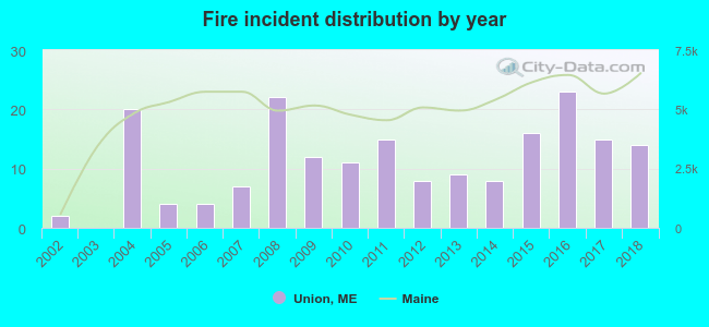 Based on the data from the years 2002 - 2018 the average number of fires per year is 11. The highest number of reported fires - 23 took place in 2016, and the least - 0 in 2003. The data has a growing trend.
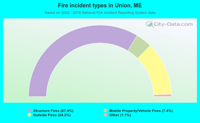 When looking into fire subcategories, the most incidents belonged to: Structure Fires (67.4%), and Outside Fires (24.2%).
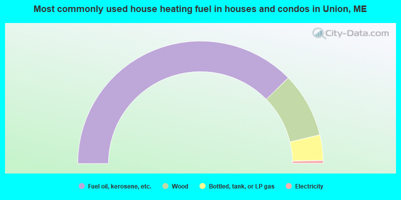
- 75.3%Fuel oil, kerosene, etc.
- 17.1%Wood
- 6.7%Bottled, tank, or LP gas
- 0.8%Electricity

- 75.9%Fuel oil, kerosene, etc.
- 12.0%Electricity
- 6.0%Wood
- 4.5%Bottled, tank, or LP gas
- 1.5%Solar energy
Union compared to Maine state average:
- Unemployed percentage below state average.
- Black race population percentage significantly below state average.
- Hispanic race population percentage significantly below state average.
- Foreign-born population percentage below state average.
- Renting percentage below state average.
- Length of stay since moving in significantly above state average.
- Number of rooms per house significantly below state average.
- House age significantly below state average.

|
Total of 6 patent applications in 2008-2024.