Victoria, Alabama
Submit your own pictures of this place and show them to the world
- OSM Map
- General Map
- Google Map
- MSN Map

| Males: 949 | |
| Females: 1,003 |
| Median resident age: | 39.2 years |
| Alabama median age: | 35.8 years |
Zip code: 36346
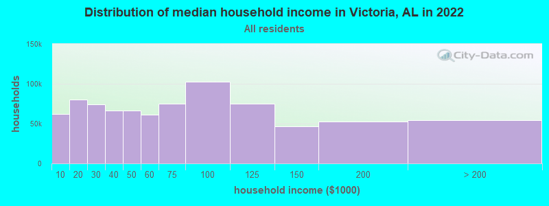
| Victoria: | $51,167 |
| AL: | $59,674 |
Estimated per capita income in 2022: $25,018 (it was $14,490 in 2000)
Victoria CCD income, earnings, and wages data
Estimated median house or condo value in 2022: $118,246 (it was $45,700 in 2000)
| Victoria: | $118,246 |
| AL: | $200,900 |
Detailed information about poverty and poor residents in Victoria, AL


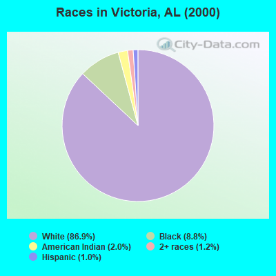
- 1,57886.9%White alone
- 1598.8%Black alone
- 362.0%American Indian alone
- 221.2%Two or more races
- 191.0%Hispanic
- 10.06%Native Hawaiian and Other
Pacific Islander alone - 10.06%Other race alone
 Recent articles from our blog. Our writers, many of them Ph.D. graduates or candidates, create easy-to-read articles on a wide variety of topics.
Current Local Time: CST time zone
Elevation: 497 feet
Land area: 80.4 square miles.
Population density: 24 people per square mile (very low).

| Victoria CCD: | 0.4% ($199) |
| Alabama: | 0.4% ($289) |
Nearest city with pop. 50,000+: Dothan, AL  (36.6 miles , pop. 57,737).
Nearest city with pop. 200,000+: Montgomery, AL (60.5 miles , pop. 201,568).
Nearest city with pop. 1,000,000+: Houston, TX (577.4 miles , pop. 1,953,631).
Nearest cities:
), ), ), Latitude: 31.55 N, Longitude: 85.90 W
Area code commonly used in this area: 334

| Here: | 2.8% |
| Alabama: | 2.6% |
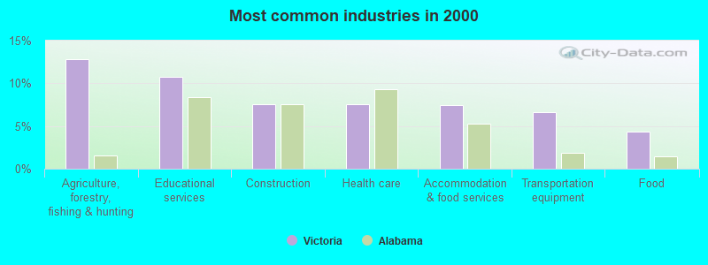
- Agriculture, forestry, fishing & hunting (12.8%)
- Educational services (10.8%)
- Construction (7.6%)
- Health care (7.6%)
- Accommodation & food services (7.5%)
- Transportation equipment (6.6%)
- Food (4.4%)
- Agriculture, forestry, fishing & hunting (17.7%)
- Construction (15.1%)
- Transportation equipment (10.9%)
- Educational services (8.0%)
- Food (5.7%)
- Truck transportation (5.2%)
- Repair & maintenance (4.0%)
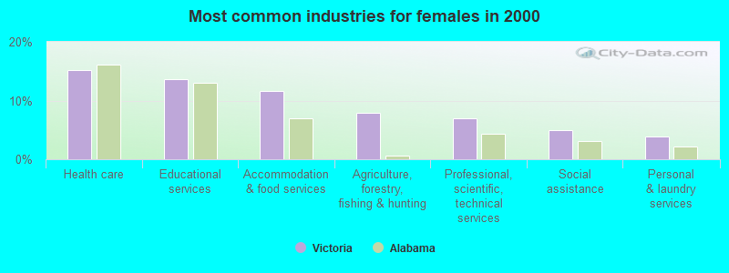
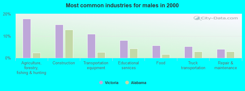
- Health care (15.2%)
- Educational services (13.6%)
- Accommodation & food services (11.7%)
- Agriculture, forestry, fishing & hunting (7.9%)
- Professional, scientific, technical services (6.9%)
- Social assistance (5.0%)
- Personal & laundry services (3.8%)
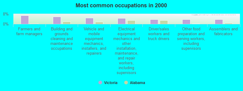
- Farmers and farm managers (6.8%)
- Building and grounds cleaning and maintenance occupations (5.9%)
- Vehicle and mobile equipment mechanics, installers, and repairers (4.7%)
- Electrical equipment mechanics and other installation, maintenance, and repair workers, including supervisors (4.5%)
- Driver/sales workers and truck drivers (3.7%)
- Other food preparation and serving workers, including supervisors (3.7%)
- Assemblers and fabricators (3.6%)
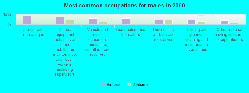
- Farmers and farm managers (10.2%)
- Electrical equipment mechanics and other installation, maintenance, and repair workers, including supervisors (9.0%)
- Vehicle and mobile equipment mechanics, installers, and repairers (7.1%)
- Assemblers and fabricators (7.1%)
- Driver/sales workers and truck drivers (5.9%)
- Building and grounds cleaning and maintenance occupations (5.4%)
- Other material moving workers, except laborers (4.7%)
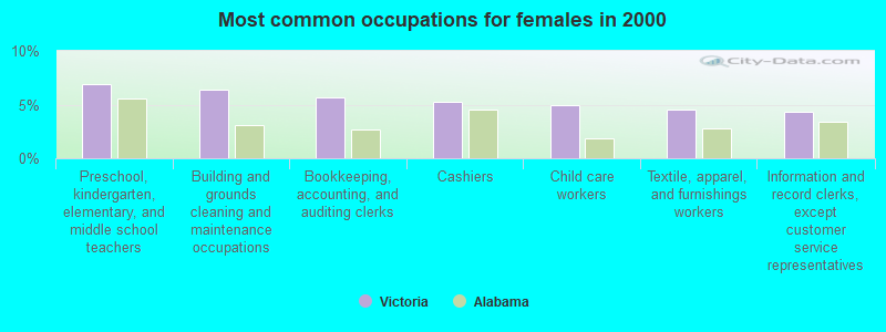
- Preschool, kindergarten, elementary, and middle school teachers (6.9%)
- Building and grounds cleaning and maintenance occupations (6.4%)
- Bookkeeping, accounting, and auditing clerks (5.7%)
- Cashiers (5.2%)
- Child care workers (5.0%)
- Textile, apparel, and furnishings workers (4.5%)
- Information and record clerks, except customer service representatives (4.3%)
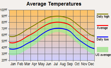
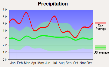
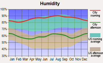
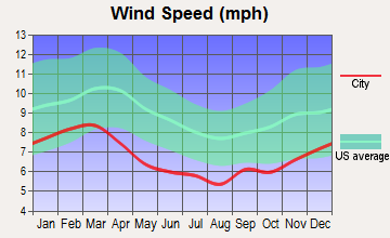
Average climate in Victoria, Alabama
Based on data reported by over 4,000 weather stations
(lower is better)
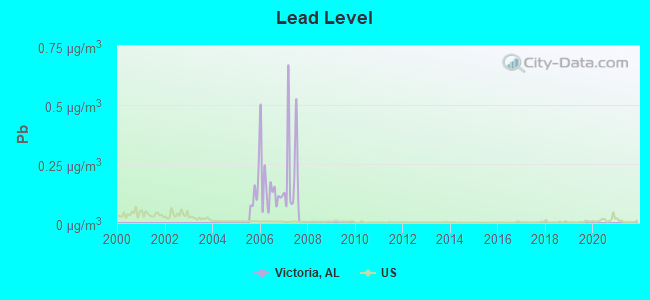
Lead (Pb) [µg/m3] level in 2007 was 0.230. This is significantly worse than average. Closest monitor was 17.6 miles away from the city center.
| City: | 0.230 |
| U.S.: | 0.009 |
Tornado activity:
Victoria-area historical tornado activity is slightly below Alabama state average. It is 48% greater than the overall U.S. average.
On 3/1/2007, a category F4 (max. wind speeds 207-260 mph) tornado 18.6 miles away from the Victoria place center killed 9 people and injured 50 people and caused $250 million in damages.
On 3/2/1971, a category F3 (max. wind speeds 158-206 mph) tornado 10.0 miles away from the place center caused between $5000 and $50,000 in damages.
Earthquake activity:
Victoria-area historical earthquake activity is significantly above Alabama state average. It is 28% greater than the overall U.S. average.On 10/24/1997 at 08:35:17, a magnitude 4.9 (4.8 MB, 4.2 MS, 4.9 LG, Depth: 6.2 mi, Class: Light, Intensity: IV - V) earthquake occurred 86.2 miles away from Victoria center
On 1/18/1999 at 07:00:53, a magnitude 4.8 (4.8 MB, 4.0 LG, Depth: 0.6 mi) earthquake occurred 150.8 miles away from the city center
On 4/29/2003 at 08:59:39, a magnitude 4.9 (4.4 MB, 4.6 MW, 4.9 LG) earthquake occurred 204.4 miles away from the city center
On 8/2/1974 at 08:52:09, a magnitude 4.9 (4.3 MB, 4.9 LG) earthquake occurred 255.5 miles away from the city center
On 11/7/2004 at 11:20:21, a magnitude 4.3 (4.3 MW, Depth: 3.1 mi) earthquake occurred 141.4 miles away from the city center
On 4/29/2003 at 08:59:39, a magnitude 4.6 (4.6 MW, Depth: 12.3 mi) earthquake occurred 204.4 miles away from Victoria center
Magnitude types: regional Lg-wave magnitude (LG), body-wave magnitude (MB), surface-wave magnitude (MS), moment magnitude (MW)
Natural disasters:
The number of natural disasters in Coffee County (23) is greater than the US average (15).Major Disasters (Presidential) Declared: 15
Emergencies Declared: 6
Causes of natural disasters: Storms: 12, Floods: 9, Hurricanes: 8, Tornadoes: 7, Winds: 4, Drought: 1, Snowfall: 1, Tropical Storm: 1, Winter Storm: 1, Other: 1 (Note: some incidents may be assigned to more than one category).
Hospitals and medical centers near Victoria:
- FIRST CHOICE HOSPICE (Hospital, about 14 miles away; ELBA, AL)
- DCI ENTERPRISE (Dialysis Facility, about 14 miles away; ENTERPRISE, AL)
- ELBA NURSING HOME (Nursing Home, about 14 miles away; ELBA, AL)
- COFFEE COUNTY HOME CARE (Home Health Center, about 14 miles away; ENTERPRISE, AL)
- WIREGRASS HOSPICE OZARK (Hospital, about 16 miles away; OZARK, AL)
Colleges/universities with over 2000 students nearest to Victoria:
- Troy University (about 18 miles; Troy, AL; Full-time enrollment: 16,148)
- Enterprise State Community College (about 18 miles; Enterprise, AL; FT enrollment: 2,101)
- George C Wallace State Community College-Dothan (about 31 miles; Dothan, AL; FT enrollment: 3,611)
- Auburn University at Montgomery (about 60 miles; Montgomery, AL; FT enrollment: 4,092)
- Faulkner University (about 61 miles; Montgomery, AL; FT enrollment: 2,887)
- Alabama State University (about 62 miles; Montgomery, AL; FT enrollment: 5,457)
- Tuskegee University (about 63 miles; Tuskegee, AL; FT enrollment: 2,810)
Points of interest:
Notable locations in Victoria: SpectraCare Health Systems Henry County Clinic (A), Five Star Volunteer Fire Department (B). Display/hide their locations on the map
Churches in Victoria include: Mount Zion Baptist Church (A), Saint John Baptist Church (B), Pleasant Ridge Primitive Baptist Church (C), New Salem Church (D), Dorcas Baptist Church (E), Corinth Primitive Baptist Church (F), Victoria Baptist Church (G), Abundant Life Emanuel Church (H), New Hope Baptist Church (I). Display/hide their locations on the map
Cemeteries: Rosin Ridge Cemetery (1), Mount Zion Cemetery (2), Strickland Cemetery (3), Chestnut Grove Cemetery (4), Hawhill Cemetery (5), Mount Zion Cemetery (6), New Hope Cemetery (7). Display/hide their locations on the map
Lakes and reservoirs: Prestwood Millpond (A), Nolin Lake (B). Display/hide their locations on the map
Streams, rivers, and creeks: Red Oak Creek (A), Johnson Creek (B), Indigo Creek (C), Harpers Mill Creek (D), Halls Creek (E), Clearwater Creek (F), Cardwell Creek (G), Turner Branch (H), Tindle Creek (I). Display/hide their locations on the map
Park in Victoria: Victoria Ball Park (1). Display/hide its location on the map
| This place: | 2.4 people |
| Alabama: | 2.5 people |
| This place: | 71.4% |
| Whole state: | 67.8% |
| This place: | 3.9% |
| Whole state: | 4.7% |
Likely homosexual households (counted as self-reported same-sex unmarried-partner households)
- Lesbian couples: 0.4% of all households
- Gay men: 0.3% of all households
| This place: | 15.3% |
| Whole state: | 16.1% |
| This place: | 6.2% |
| Whole state: | 7.3% |
For population 15 years and over in Victoria:
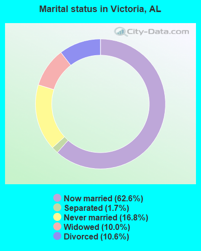
- Never married: 16.8%
- Now married: 62.6%
- Separated: 1.7%
- Widowed: 10.0%
- Divorced: 10.6%
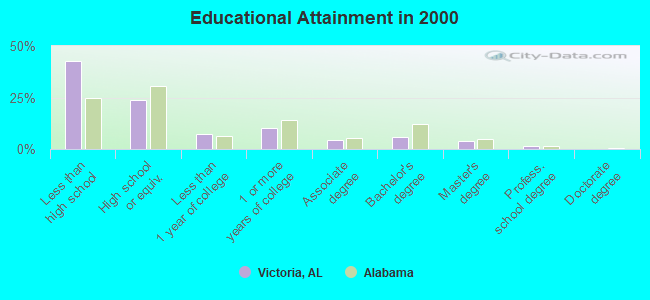
For population 25 years and over in Victoria:
- High school or higher: 57.2%
- Bachelor's degree or higher: 11.1%
- Graduate or professional degree: 5.4%
- Unemployed: 3.2%
- Mean travel time to work (commute): 26.9 minutes
| Here: | 17.6 |
| Alabama average: | 13.2 |
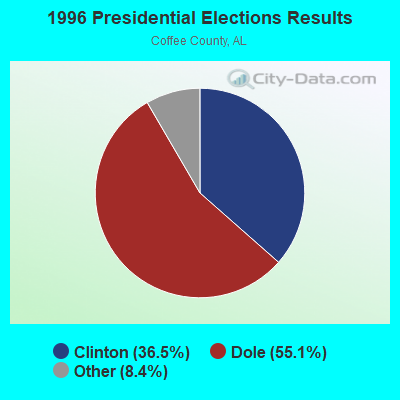
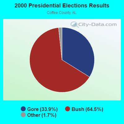
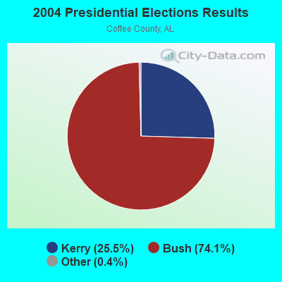
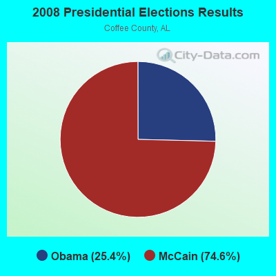
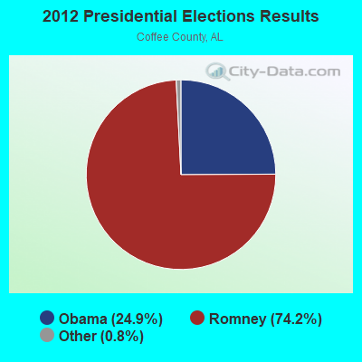
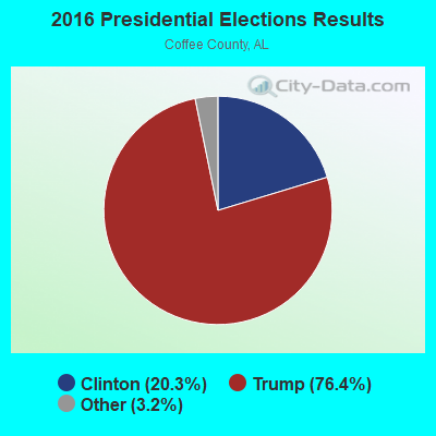
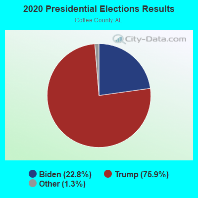
Graphs represent county-level data. Detailed 2008 Election Results
Religion statistics for Victoria, AL (based on Coffee County data)
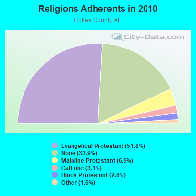
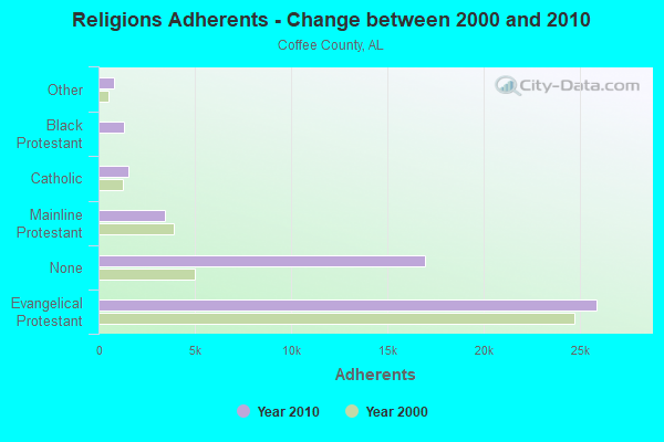
| Religion | Adherents | Congregations |
|---|---|---|
| Evangelical Protestant | 25,889 | 91 |
| Mainline Protestant | 3,457 | 13 |
| Catholic | 1,550 | 1 |
| Black Protestant | 1,320 | 11 |
| Other | 805 | 4 |
| None | 16,927 | - |
Food Environment Statistics:
| Coffee County: | 1.28 / 10,000 pop. |
| Alabama: | 1.89 / 10,000 pop. |
| This county: | 0.21 / 10,000 pop. |
| Alabama: | 0.20 / 10,000 pop. |
| Here: | 0.86 / 10,000 pop. |
| State: | 0.65 / 10,000 pop. |
| Here: | 7.06 / 10,000 pop. |
| Alabama: | 6.32 / 10,000 pop. |
| Here: | 7.91 / 10,000 pop. |
| Alabama: | 5.75 / 10,000 pop. |
| Coffee County: | 10.8% |
| Alabama: | 11.8% |
| Coffee County: | 32.5% |
| Alabama: | 31.7% |
| This county: | 16.6% |
| State: | 13.5% |
10.82% of this county's 2021 resident taxpayers lived in other counties in 2020 ($53,280 average adjusted gross income)
| Here: | 10.82% |
| Alabama average: | 6.87% |
0.18% of residents moved from foreign countries ($1,154 average AGI)
Coffee County: 0.18% Alabama average: 0.02%
Top counties from which taxpayers relocated into this county between 2020 and 2021:
| from Dale County, AL | |
| from Houston County, AL | |
| from Geneva County, AL |
10.45% of this county's 2020 resident taxpayers moved to other counties in 2021 ($53,500 average adjusted gross income)
| Here: | 10.45% |
| Alabama average: | 6.41% |
0.21% of residents moved to foreign countries ($1,557 average AGI)
Coffee County: 0.21% Alabama average: 0.02%
Top counties to which taxpayers relocated from this county between 2020 and 2021:
| to Dale County, AL | |
| to Houston County, AL | |
| to Geneva County, AL |
Strongest AM radio stations in Victoria:
- WQLS (1200 AM; 10 kW; OZARK, AL; Owner: STYLES BROADCASTING OF DOTHAN, INC.)
- WTBF (970 AM; 5 kW; TROY, AL; Owner: TROY BROADCASTING CORP.)
- WTKN (1560 AM; daytime; 5 kW; DALEVILLE, AL; Owner: JOSEPH A. ADAMS, SR.)
- WELB (1350 AM; 1 kW; ELBA, AL; Owner: ELBA RADIO COMPANY)
- WOZK (900 AM; 1 kW; OZARK, AL; Owner: OZARK B/CING. CORP.)
- WOOF (560 AM; 5 kW; DOTHAN, AL; Owner: WOOF, INC.)
- WASG (550 AM; 25 kW; ATMORE, AL; Owner: 550 AM, INC)
- WMSP (740 AM; 10 kW; MONTGOMERY, AL; Owner: CUMULUS LICENSING CORP.)
- WJOX (690 AM; 50 kW; BIRMINGHAM, AL; Owner: CITADEL BROADCASTING COMPANY)
- WOPP (1290 AM; 2 kW; OPP, AL; Owner: E. & R BROADCASTING, INC.)
- WDJC (850 AM; 50 kW; BIRMINGHAM, AL; Owner: KIMTRON, INC.)
- WGST (640 AM; 50 kW; ATLANTA, GA; Owner: CITICASTERS LICENSES, L.P.)
- WNSI (810 AM; 50 kW; JACKSONVILLE, AL; Owner: UNITED BROADCASTING NETWORK, INC.)
Strongest FM radio stations in Victoria:
- WKMX (106.7 FM; ENTERPRISE, AL; Owner: WKMX, INC.)
- WZTZ (101.1 FM; ELBA, AL; Owner: ELBA RADIO COMPANY)
- WQLD (104.3 FM; LUVERNE, AL; Owner: CAPSTAR TX LIMITED PARTNERSHIP)
- WZHT (105.7 FM; TROY, AL; Owner: CAPSTAR TX LIMITED PARTNERSHIP)
- WTBF-FM (94.7 FM; BRUNDIDGE, AL; Owner: TROY BROADCASTING CORPORATION)
- WAXU (91.1 FM; TROY, AL; Owner: AMERICAN FAMILY ASSOCIATION)
- WDJR (96.9 FM; ENTERPRISE, AL; Owner: GULF SOUTH COMMUNICATIONS, INC.)
- WDYF (90.3 FM; DOTHAN, AL; Owner: FAITH BROADCASTING, INC.)
- WLWI-FM (92.3 FM; MONTGOMERY, AL; Owner: CUMULUS LICENSING CORP.)
- WOAB (104.9 FM; OZARK, AL; Owner: OZARK BROADCASTING CORPORATION)
- WRJM-FM (93.7 FM; GENEVA, AL; Owner: STAGE DOOR DEVELOPMENT, INC.)
- WOOF-FM (99.7 FM; DOTHAN, AL; Owner: WOOF, INC.)
- WTVY-FM (95.5 FM; DOTHAN, AL; Owner: STYLES BROADCASTING OF DOTHAN, INC.)
- WXUS (100.5 FM; FORT RUCKER, AL; Owner: SKYWAY BROADCASTING, LTD.)
- WTSU (89.9 FM; MONTGOMERY-TROY, AL; Owner: TROY STATE UNIVERSITY)
- WAQG (91.7 FM; OZARK, AL; Owner: AMERICAN FAMILY ASSOCIATION)
- WAOQ (100.3 FM; BRANTLEY, AL; Owner: ALATRON CORPORATION, INC.)
- WRWA (88.7 FM; DOTHAN, AL; Owner: TROY STATE UNIVERSITY)
TV broadcast stations around Victoria:
- WRJM-TV (Channel 67; TROY, AL; Owner: JOSIE PARK BROADCASTING, INC.)
- WSFA (Channel 12; MONTGOMERY, AL; Owner: LIBCO, INC.)
- WDIQ (Channel 2; DOZIER, AL; Owner: ALABAMA EDUCATIONAL TELEVISION COMMISSION)
- WCOV-TV (Channel 20; MONTGOMERY, AL; Owner: WOODS COMMUNICATIONS CORPORATION)
- WTVY (Channel 4; DOTHAN, AL; Owner: GRAY MIDAMERICA TV LICENSEE CORP.)
- WDFX-TV (Channel 34; OZARK, AL; Owner: WAITT LICENSE CO. OF ALABAMA, L.L.C.)
- WGIQ (Channel 43; LOUISVILLE, AL; Owner: ALABAMA EDUCATIONAL TELEVISION COMMISSION)
FCC Registered Cell Phone Towers:
1 (See the full list of FCC Registered Cell Phone Towers in Victoria)FCC Registered Antenna Towers:
23 (See the full list of FCC Registered Antenna Towers)FCC Registered Broadcast Land Mobile Towers:
2- Cr210 1 Mi From 125 (Lat: 31.534333 Lon: -85.946056), Type: Tower, Structure height: 49 m, Overall height: 55 m, Call Sign: WPEA217,
Assigned Frequencies: 158.460 MHz, Grant Date: 04/07/1999, Expiration Date: 04/07/2004, Cancellation Date: 06/13/2004, Certifier: Richard J Spurlin Jr, Registrant: Federal Licensing Inc, 1588 Fairfield Rd, Gettysburg, PA 17325-7252, Fax: (717) 334-6440
- Hwy 125 2.3 Mi Ne (Lat: 31.554056 Lon: -85.907722), Call Sign: WNXZ495, Licensee ID: L00003541,
Assigned Frequencies: 457.300 MHz, Grant Date: 10/12/2001, Expiration Date: 12/16/2011, Cancellation Date: 07/03/2002, Registrant: Alabama Electric Cooperative Inc, Andalusia, AL 36420, Phone: (205) 222-2571
FCC Registered Microwave Towers:
7- Victoria Fire Tower (Lat: 31.487083 Lon: -85.968556), Overall height: 33.5 m, Call Sign: WMU927,
Assigned Frequencies: 7100.00 MHz, Grant Date: 06/15/1994, Expiration Date: 04/01/1997, Cancellation Date: 08/21/1996, Registrant: Woods Communications Corporation, 1 Wcov Ave, Montgomery, AL 36111
- .5 Mi Sw Of The Community Of Victoria 10 Mi Ne (Lat: 31.524583 Lon: -85.943000), Overall height: 82.3 m, Call Sign: WPNA349,
Assigned Frequencies: 928.081 MHz, 952.081 MHz, Grant Date: 01/29/2002, Expiration Date: 04/01/2012, Cancellation Date: 06/02/2012, Registrant: Powersouth Energy Cooperative, 2027 East Three Notch St., Andalusia, AL 36420, Phone: (334) 427-3000, Fax: (334) 427-3439, Email:
- VICTORIA TW, Victoria Tower (Lat: 31.487083 Lon: -85.968556), Overall height: 48.8 m, Call Sign: WNTN678,
Assigned Frequencies: 6123.10 MHz, 6063.80 MHz, 1860.00 MHz, Grant Date: 10/05/2001, Expiration Date: 12/09/2011, Cancellation Date: 03/08/2004, Phone: (334) 670-3268
- VICTORIA, Hwy 125 .5 Mi Sw (Lat: 31.524639 Lon: -85.943000), Type: Gtower, Structure height: 106 m, Call Sign: WCF268,
Assigned Frequencies: 6063.80 MHz, 6123.10 MHz, 5945.20 MHz, 5945.20 MHz, 5945.20 MHz, 5945.20 MHz, 5945.20 MHz, 5945.20 MHz, 5945.20 MHz, 5945.20 MHz... (+28 more), Grant Date: 06/10/2020, Expiration Date: 07/05/2030, Registrant: Powersouth Energy Cooperative, 2027 East Three Notch St., Andalusia, AL 36420, Phone: (334) 427-3245, Fax: (334) 427-3439, Email:
- Victoria Tower (Lat: 31.487083 Lon: -85.968556), Overall height: 33.5 m, Call Sign: WLD642, Licensee ID: L00002686,
Assigned Frequencies: 951.500 MHz, Grant Date: 12/26/1984, Expiration Date: 04/01/2004, Cancellation Date: 03/05/2004, Registrant: Troy State University, University Ave, Troy, AL 36082
- Victoria Lookout Tower (Lat: 31.487083 Lon: -85.968556), Call Sign: WLJ920, Licensee ID: L00094087,
Assigned Frequencies: 7000.00 MHz, Grant Date: 09/26/1988, Expiration Date: 04/01/2013, Cancellation Date: 08/29/2012, Registrant: Woods Communications Corporation, One Wcov Avenue, Montgomery, AL 36111
- VICTORIA, 1.8 Mi S Of (Lat: 31.503750 Lon: -85.954667), Overall height: 79.2 m, Call Sign: WLM947,
Assigned Frequencies: 5974.85 MHz, 5974.85 MHz, 6034.15 MHz, 6034.15 MHz, 6093.45 MHz, 6093.45 MHz, 6152.75 MHz, 6152.75 MHz, Grant Date: 02/02/2010, Expiration Date: 02/01/2020, Cancellation Date: 12/20/2012, Certifier: Paul Wilson, Registrant: At&t Services, Inc., 1120 20th Street, Nw, Suite 1000, Washington, DC 20036, Phone: (202) 457-3048, Fax: (202) 457-3073, Email:
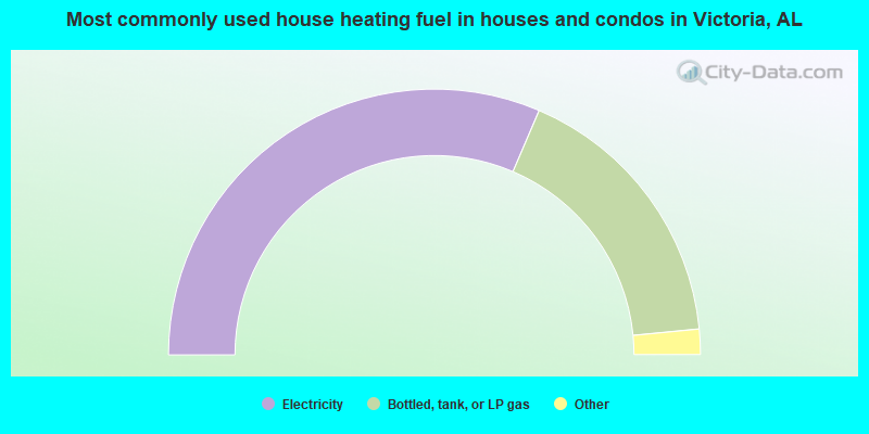
- 62.9%Electricity
- 34.0%Bottled, tank, or LP gas
- 2.2%Utility gas
- 0.9%Wood
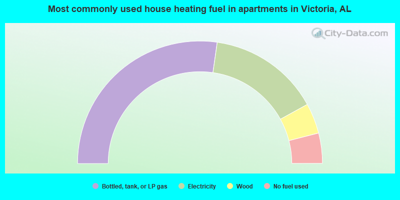
- 54.5%Bottled, tank, or LP gas
- 29.5%Electricity
- 8.0%Wood
- 8.0%No fuel used
Victoria compared to Alabama state average:
- Median house value below state average.
- Unemployed percentage significantly below state average.
- Black race population percentage below state average.
- Hispanic race population percentage significantly below state average.
- Foreign-born population percentage significantly below state average.
- Renting percentage below state average.
- Length of stay since moving in significantly above state average.
- Number of rooms per house significantly below state average.
- House age significantly below state average.
- Number of college students below state average.
- Percentage of population with a bachelor's degree or higher below state average.