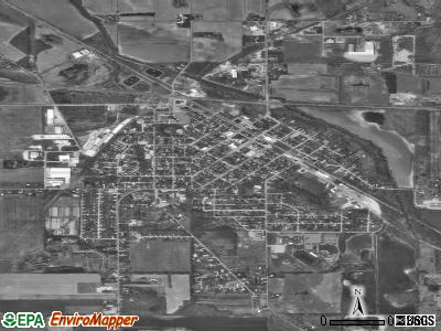
Walkerton, Indiana
Submit your own pictures of this town and show them to the world
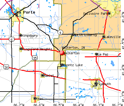
- OSM Map
- General Map
- Google Map
- MSN Map
Population change since 2000: -8.5%
 |
| Males: 909 | |
| Females: 1,172 |
| Median resident age: | 34.3 years |
| Indiana median age: | 38.2 years |
Zip codes: 46574.
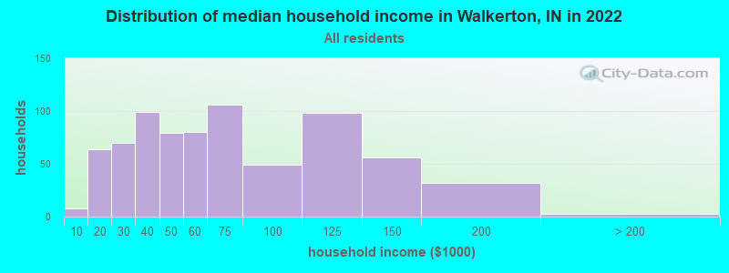
| Walkerton: | $57,370 |
| IN: | $66,785 |
Estimated per capita income in 2022: $24,836 (it was $15,122 in 2000)
Walkerton town income, earnings, and wages data
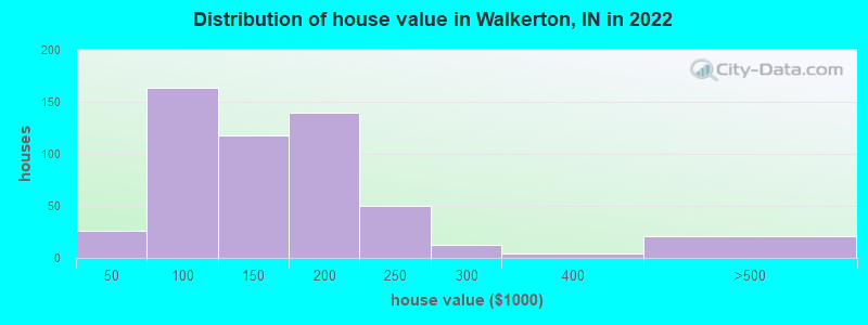
Estimated median house or condo value in 2022: $140,126 (it was $76,900 in 2000)
| Walkerton: | $140,126 |
| IN: | $208,700 |
Mean prices in 2022: all housing units: $148,089; detached houses: $148,508
Median gross rent in 2022: $811.
(4.5% for White Non-Hispanic residents, 60.7% for other race residents, 5.6% for two or more races residents)
Detailed information about poverty and poor residents in Walkerton, IN


Compare current foreclosures near Walkerton, IN:
| Photo | Address | Area | Beds / Baths | Price | Details |
|---|---|---|---|---|---|

|
#1
Clover Dr
Walkerton, IN 46574
|
896 sq. feet
|
1 baths 2 beds |
$32,500
|
show details |

|
#2
Kentucky St
Walkerton, IN 46574
|
868 sq. feet
|
1 baths 1 beds |
show details | |

|
#3
Fern Dr
Walkerton, IN 46574
|
1,171 sq. feet
|
1 baths 3 beds |
show details | |

|
#4
N 1150 E
Walkerton, IN 46574
|
728 sq. feet
|
1 baths 2 beds |
show details | |

|
#5
Ohio St
Walkerton, IN 46574
|
1,670 sq. feet
|
1 baths 3 beds |
show details | |

|
#6
Lilac Ln
Walkerton, IN 46574
|
1,072 sq. feet
|
1 baths 3 beds |
show details | |

|
#7
Sunset Dr
Walkerton, IN 46574
|
1,056 sq. feet
|
1 baths 2 beds |
show details | |

|
#8
E 700 N
Walkerton, IN 46574
|
480 sq. feet
|
1 baths 1 beds |
show details | |

|
#9
Lake St
Walkerton, IN 46574
|
- sq. feet
|
- baths - beds |
show details | |

|
#10
Red Tail Ct
Walkerton, IN 46574
|
- sq. feet
|
- baths - beds |
show details |
| Photo | Address | Area | Beds / Baths | Price | Details |
|---|---|---|---|---|---|

|
#11
E State Road 4
Walkerton, IN 46574
|
- sq. feet
|
- baths - beds |
show details | |

|
#12
E State Road 4
Walkerton, IN 46574
|
- sq. feet
|
- baths - beds |
show details | |

|
#13
N High St
Walkerton, IN 46574
|
- sq. feet
|
- baths - beds |
show details | |

|
#14
Woodcreek Dr
Walkerton, IN 46574
|
- sq. feet
|
- baths - beds |
show details | |

|
#15
Gdn Ln
South Bend, IN 46619
|
767 sq. feet
|
1 baths 2 beds |
$54,150
|
show details |

|
#16
Friendship Ln
Walkerton, IN 46574
|
- sq. feet
|
- baths - beds |
show details | |

|
#17
E 100 N
Knox, IN 46534
|
- sq. feet
|
1 baths 3 beds |
$39,900
|
show details |

|
#18
E 200 S
Knox, IN 46534
|
1,420 sq. feet
|
1 baths 3 beds |
show details | |

|
#19
Chestnut St
Laporte, IN 46350
|
1,040 sq. feet
|
1 baths 2 beds |
show details | |

|
#20
E Long Lane Dr
Knox, IN 46534
|
- sq. feet
|
3 baths 3 beds |
show details |
| Photo | Address | Area | Beds / Baths | Price | Details |
|---|---|---|---|---|---|

|
#21
Louisa St
Plymouth, IN 46563
|
1,440 sq. feet
|
2 baths 3 beds |
show details | |

|
#22
Fairbanks Ave
Plymouth, IN 46563
|
1,512 sq. feet
|
2 baths 3 beds |
show details | |

|
#23
Williams St
Knox, IN 46534
|
- sq. feet
|
1 baths 3 beds |
show details | |

|
#24
Meridian St
New Carlisle, IN 46552
|
1,343 sq. feet
|
1 baths 3 beds |
show details | |

|
#25
E Debby Dr
Knox, IN 46534
|
1,284 sq. feet
|
1 baths 3 beds |
show details | |

|
#26
Gumwood Rd
Bremen, IN 46506
|
1,008 sq. feet
|
1 baths 3 beds |
show details | |

|
#27
Corvette Dr
Laporte, IN 46350
|
1,176 sq. feet
|
1 baths 3 beds |
show details | |

|
#28
N Cummings St
Union Mills, IN 46382
|
1,714 sq. feet
|
1 baths 2 beds |
show details | |

|
#29
Indiana Ave
Laporte, IN 46350
|
2,864 sq. feet
|
2 baths 3 beds |
show details | |

|
#30
Pinewood Dr
South Bend, IN 46619
|
1,756 sq. feet
|
1 baths 3 beds |
show details |
| Photo | Address | Area | Beds / Baths | Price | Details |
|---|---|---|---|---|---|

|
#31
E Lincolnway
Laporte, IN 46350
|
1,332 sq. feet
|
1 baths 3 beds |
show details | |

|
#32
Niles St
Laporte, IN 46350
|
1,034 sq. feet
|
1 baths 2 beds |
show details | |

|
#33
Warwick St
Laporte, IN 46350
|
3,188 sq. feet
|
2 baths 3 beds |
show details | |

|
#34
E Robin Ct
Rolling Prairie, IN 46371
|
2,128 sq. feet
|
1 baths 3 beds |
show details | |

|
#35
S Albert Ave
South Bend, IN 46619
|
672 sq. feet
|
1 baths 2 beds |
show details | |

|
#36
Barbie St
South Bend, IN 46614
|
864 sq. feet
|
1 baths 3 beds |
show details | |

|
#37
E 10th St
Laporte, IN 46350
|
1,009 sq. feet
|
1 baths 3 beds |
show details | |

|
#38
E Hamilton St
Union Mills, IN 46382
|
1,072 sq. feet
|
1 baths 2 beds |
show details | |

|
#39
Sunset Ct
Plymouth, IN 46563
|
1,537 sq. feet
|
2 baths 3 beds |
show details | |

|
#40
W 800 S
Union Mills, IN 46382
|
1,020 sq. feet
|
1 baths 2 beds |
show details |
| Photo | Address | Area | Beds / Baths | Price | Details |
|---|---|---|---|---|---|

|
#41
N Morning Glory Ave
Rolling Prairie, IN 46371
|
2,962 sq. feet
|
2 baths 3 beds |
show details | |

|
#42
S Dorothy St
South Bend, IN 46613
|
616 sq. feet
|
1 baths 3 beds |
show details | |

|
#43
E 200 S
Knox, IN 46534
|
1,080 sq. feet
|
1 baths 3 beds |
show details | |

|
#44
Albin Dr
Laporte, IN 46350
|
1,008 sq. feet
|
1 baths 3 beds |
show details | |

|
#45
Binkley Dr
Knox, IN 46534
|
1,008 sq. feet
|
1 baths 3 beds |
show details | |

|
#46
Traders Post Ln
South Bend, IN 46619
|
1,582 sq. feet
|
2 baths 4 beds |
show details | |

|
#47
Airway Dr
Knox, IN 46534
|
912 sq. feet
|
1 baths 2 beds |
show details | |

|
#48
Irvington Ave
South Bend, IN 46619
|
1,032 sq. feet
|
1 baths 3 beds |
show details | |

|
#49
Coral Ct
Plymouth, IN 46563
|
2,136 sq. feet
|
2 baths 4 beds |
show details | |

|
Check over 1 million property listings on Foreclosure.com!
|
browse all offers | |||


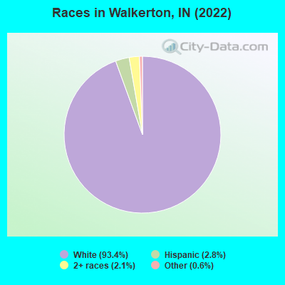
- 1,88693.4%White alone
- 562.8%Hispanic
- 422.1%Two or more races
- 120.6%Other race alone
- 20.10%Asian alone
Races in Walkerton detailed stats: ancestries, foreign born residents, place of birth
According to our research of Indiana and other state lists, there was 1 registered sex offender living in Walkerton, Indiana as of May 14, 2024.
The ratio of all residents to sex offenders in Walkerton is 2,098 to 1.
The ratio of registered sex offenders to all residents in this city is much lower than the state average.
Type |
2009 |
2010 |
2011 |
2012 |
2013 |
2014 |
2015 |
2016 |
2017 |
2018 |
2019 |
2020 |
2021 |
2022 |
|---|---|---|---|---|---|---|---|---|---|---|---|---|---|---|
| Murders (per 100,000) | 0 (0.0) | 0 (0.0) | 0 (0.0) | 0 (0.0) | 0 (0.0) | 0 (0.0) | 0 (0.0) | 0 (0.0) | 0 (0.0) | 0 (0.0) | 0 (0.0) | 0 (0.0) | 0 (0.0) | 0 (0.0) |
| Rapes (per 100,000) | 0 (0.0) | 0 (0.0) | 1 (46.4) | 0 (0.0) | 1 (43.8) | 0 (0.0) | 0 (0.0) | 1 (43.7) | 0 (0.0) | 0 (0.0) | 0 (0.0) | 0 (0.0) | 0 (0.0) | 0 (0.0) |
| Robberies (per 100,000) | 0 (0.0) | 0 (0.0) | 1 (46.4) | 0 (0.0) | 0 (0.0) | 0 (0.0) | 0 (0.0) | 1 (43.7) | 0 (0.0) | 0 (0.0) | 0 (0.0) | 0 (0.0) | 0 (0.0) | 0 (0.0) |
| Assaults (per 100,000) | 4 (184.8) | 2 (93.3) | 1 (46.4) | 0 (0.0) | 0 (0.0) | 1 (43.9) | 2 (87.5) | 0 (0.0) | 0 (0.0) | 1 (43.8) | 5 (219.9) | 3 (132.2) | 5 (221.1) | 5 (240.4) |
| Burglaries (per 100,000) | 24 (1,109) | 9 (419.8) | 10 (464.0) | 6 (279.2) | 12 (525.4) | 6 (263.6) | 4 (175.1) | 4 (174.7) | 1 (43.8) | 2 (87.5) | 6 (263.9) | 5 (220.4) | 3 (132.7) | 27 (1,298) |
| Thefts (per 100,000) | 46 (2,126) | 18 (839.6) | 23 (1,067) | 15 (698.0) | 27 (1,182) | 7 (307.6) | 27 (1,182) | 12 (524.2) | 1 (43.8) | 0 (0.0) | 11 (483.7) | 18 (793.3) | 10 (442.3) | 15 (721.2) |
| Auto thefts (per 100,000) | 5 (231.1) | 3 (139.9) | 5 (232.0) | 1 (46.5) | 5 (218.9) | 3 (131.8) | 0 (0.0) | 0 (0.0) | 0 (0.0) | 0 (0.0) | 2 (88.0) | 4 (176.3) | 3 (132.7) | 3 (144.2) |
| Arson (per 100,000) | 1 (46.2) | 1 (46.6) | 1 (46.4) | 1 (46.5) | 0 (0.0) | 1 (43.9) | 4 (175.1) | 0 (0.0) | 0 (0.0) | 0 (0.0) | 0 (0.0) | 0 (0.0) | 0 (0.0) | 0 (0.0) |
| City-Data.com crime index | 218.1 | 92.8 | 154.1 | 51.2 | 136.6 | 50.1 | 77.0 | 81.3 | 4.8 | 14.9 | 88.8 | 87.7 | 81.8 | 179.3 |
The City-Data.com crime index weighs serious crimes and violent crimes more heavily. Higher means more crime, U.S. average is 246.1. It adjusts for the number of visitors and daily workers commuting into cities.
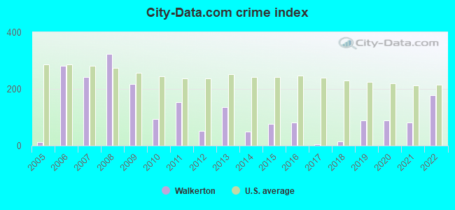
Crime rate in Walkerton detailed stats: murders, rapes, robberies, assaults, burglaries, thefts, arson
Full-time law enforcement employees in 2021, including police officers: 10 (6 officers - 6 male; 0 female).
| Officers per 1,000 residents here: | 2.65 |
| Indiana average: | 2.16 |
 Recent articles from our blog. Our writers, many of them Ph.D. graduates or candidates, create easy-to-read articles on a wide variety of topics.

 | St. Joseph County Indiana stays blue (4 replies) |
| Indianapolis more like Minneapolis or Louisville (362 replies) |
| Guitar Players (1 reply) |
| Apartments between Walkerton & Fishers (5 replies) |
| Rentals-House/Twnhouse/Duplex/Apts Laporte, IN (9 replies) |
| Farmers markets, CSAs, organic coffee, pasture raised chickens-eggs (2 replies) |
Latest news from Walkerton, IN collected exclusively by city-data.com from local newspapers, TV, and radio stations
Ancestries: German (21.0%), English (16.5%), American (14.7%), Irish (9.3%), Croatian (4.9%), Polish (3.6%).
Current Local Time: EST time zone
Elevation: 707 feet
Land area: 1.74 square miles.
Population density: 1,199 people per square mile (low).
54 residents are foreign born (2.1% Europe).
| This town: | 2.7% |
| Indiana: | 5.6% |
Median real estate property taxes paid for housing units with mortgages in 2022: $1,307 (0.9%)
Median real estate property taxes paid for housing units with no mortgage in 2022: $1,486 (1.1%)
Nearest city with pop. 50,000+: South Bend, IN  (18.7 miles , pop. 107,789).
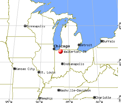
Nearest city with pop. 200,000+: Chicago, IL (67.0 miles , pop. 2,896,016).
Nearest cities:
), ), ), )Latitude: 41.46 N, Longitude: 86.48 W
Area code: 574
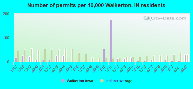
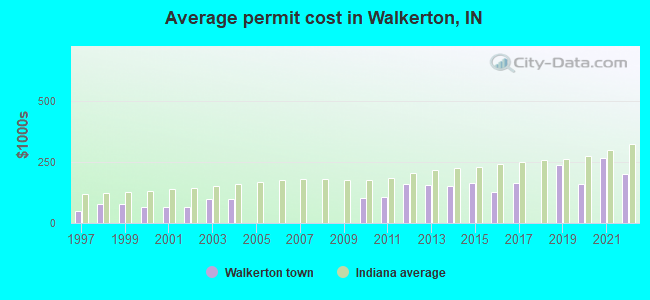
Single-family new house construction building permits:
- 2022: 7 buildings, average cost: $199,500
- 2021: 1 building, cost: $265,000
- 2020: 1 building, cost: $160,000
- 2019: 2 buildings, average cost: $236,900
- 2017: 2 buildings, average cost: $163,500
- 2016: 1 building, cost: $126,000
- 2015: 1 building, cost: $165,000
- 2014: 4 buildings, average cost: $151,300
- 2013: 3 buildings, average cost: $153,700
- 2012: 3 buildings, average cost: $161,200
- 2011: 40 buildings, average cost: $106,500
- 2010: 12 buildings, average cost: $102,300
- 2004: 6 buildings, average cost: $99,000
- 2003: 6 buildings, average cost: $99,000
- 2002: 2 buildings, average cost: $65,000
- 2001: 2 buildings, average cost: $65,000
- 2000: 2 buildings, average cost: $65,000
- 1999: 5 buildings, average cost: $79,800
- 1998: 6 buildings, average cost: $77,200
- 1997: 4 buildings, average cost: $50,700
| Here: | 3.3% |
| Indiana: | 2.8% |
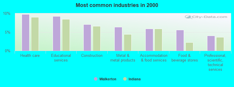
- Health care (9.7%)
- Educational services (9.2%)
- Construction (7.1%)
- Metal & metal products (6.3%)
- Accommodation & food services (5.9%)
- Food & beverage stores (5.6%)
- Professional, scientific, technical services (4.0%)
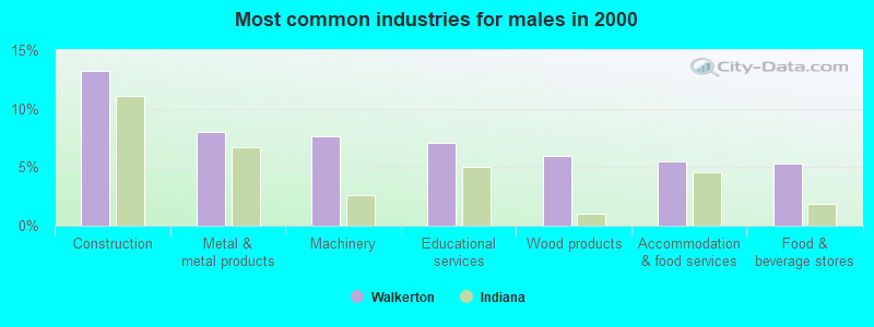
- Construction (13.3%)
- Metal & metal products (8.0%)
- Machinery (7.6%)
- Educational services (7.1%)
- Wood products (6.0%)
- Accommodation & food services (5.5%)
- Food & beverage stores (5.3%)
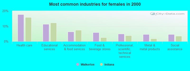
- Health care (17.7%)
- Educational services (11.3%)
- Accommodation & food services (6.3%)
- Food & beverage stores (5.9%)
- Professional, scientific, technical services (5.0%)
- Metal & metal products (4.6%)
- Social assistance (4.6%)
- Metal workers and plastic workers (6.7%)
- Material recording, scheduling, dispatching, and distributing workers (6.3%)
- Other production occupations, including supervisors (4.8%)
- Preschool, kindergarten, elementary, and middle school teachers (4.0%)
- Vehicle and mobile equipment mechanics, installers, and repairers (3.7%)
- Laborers and material movers, hand (3.7%)
- Cooks and food preparation workers (3.5%)
- Metal workers and plastic workers (10.5%)
- Material recording, scheduling, dispatching, and distributing workers (7.6%)
- Vehicle and mobile equipment mechanics, installers, and repairers (7.3%)
- Other production occupations, including supervisors (6.7%)
- Construction traders workers except carpenters, electricians, painters, plumbers, and construction laborers (6.4%)
- Electrical equipment mechanics and other installation, maintenance, and repair workers, including supervisors (6.0%)
- Laborers and material movers, hand (5.5%)

- Cashiers (6.5%)
- Preschool, kindergarten, elementary, and middle school teachers (5.4%)
- Cooks and food preparation workers (5.2%)
- Other office and administrative support workers, including supervisors (5.0%)
- Material recording, scheduling, dispatching, and distributing workers (5.0%)
- Nursing, psychiatric, and home health aides (5.0%)
- Secretaries and administrative assistants (4.6%)
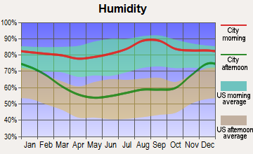
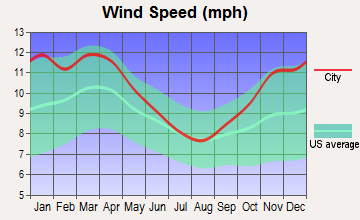
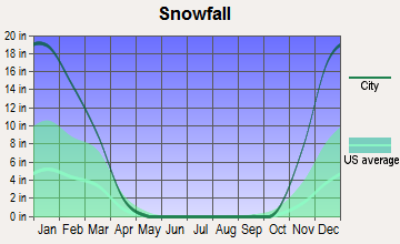
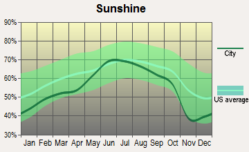
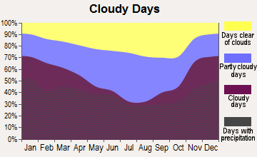
Average climate in Walkerton, Indiana
Based on data reported by over 4,000 weather stations
|
|


(lower is better)
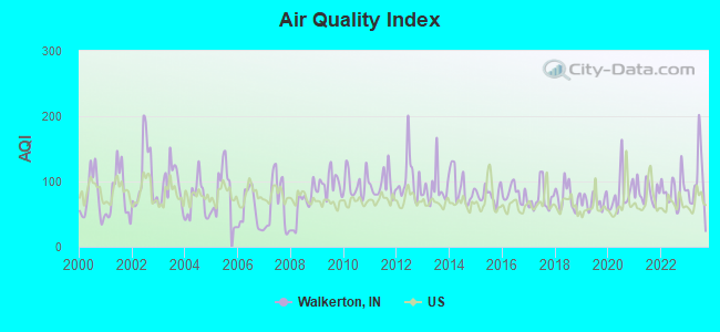
Air Quality Index (AQI) level in 2023 was 96.7. This is worse than average.
| City: | 96.7 |
| U.S.: | 72.6 |
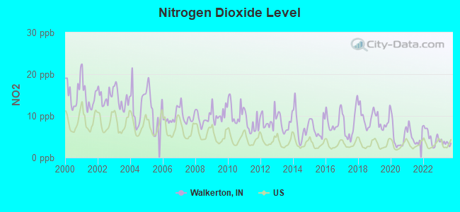
Nitrogen Dioxide (NO2) [ppb] level in 2023 was 3.52. This is significantly better than average. Closest monitor was 15.8 miles away from the city center.
| City: | 3.52 |
| U.S.: | 5.11 |
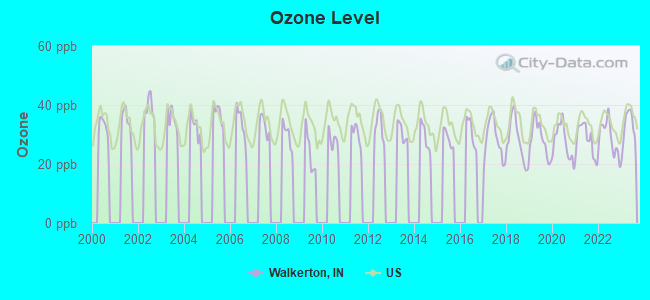
Ozone [ppb] level in 2023 was 32.4. This is about average. Closest monitor was 0.2 miles away from the city center.
| City: | 32.4 |
| U.S.: | 33.3 |
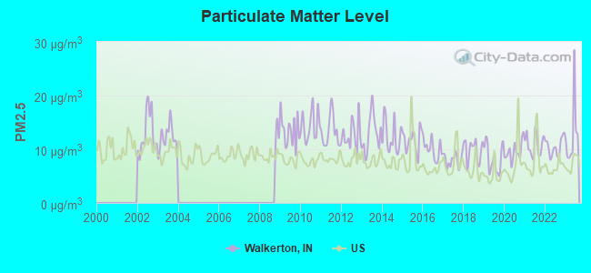
Particulate Matter (PM2.5) [µg/m3] level in 2023 was 12.7. This is significantly worse than average. Closest monitor was 15.9 miles away from the city center.
| City: | 12.7 |
| U.S.: | 8.1 |
Tornado activity:
Walkerton-area historical tornado activity is near Indiana state average. It is 70% greater than the overall U.S. average.
On 4/11/1965, a category F4 (max. wind speeds 207-260 mph) tornado 16.8 miles away from the Walkerton town center killed 36 people and injured 321 people.
On 4/11/1965, a category F4 tornado 21.8 miles away from the town center killed 31 people and injured 252 people.
Earthquake activity:
Walkerton-area historical earthquake activity is significantly above Indiana state average. It is 20% greater than the overall U.S. average.On 4/18/2008 at 09:36:59, a magnitude 5.4 (5.1 MB, 4.8 MS, 5.4 MW, 5.2 MW, Class: Moderate, Intensity: VI - VII) earthquake occurred 221.2 miles away from the city center
On 6/10/1987 at 23:48:54, a magnitude 5.1 (4.9 MB, 4.4 MS, 4.6 MS, 5.1 LG) earthquake occurred 197.2 miles away from the city center
On 4/18/2008 at 09:36:59, a magnitude 5.2 (5.2 MW, Depth: 8.9 mi) earthquake occurred 221.2 miles away from Walkerton center
On 7/27/1980 at 18:52:21, a magnitude 5.2 (5.1 MB, 4.7 MS, 5.0 UK, 5.2 UK) earthquake occurred 262.7 miles away from the city center
On 7/12/1986 at 08:19:37, a magnitude 4.5 (4.5 MB, Class: Light, Intensity: IV - V) earthquake occurred 127.6 miles away from Walkerton center
On 5/2/2015 at 16:23:07, a magnitude 4.2 (4.2 MW, Depth: 2.8 mi) earthquake occurred 76.2 miles away from Walkerton center
Magnitude types: regional Lg-wave magnitude (LG), body-wave magnitude (MB), surface-wave magnitude (MS), moment magnitude (MW)
Natural disasters:
The number of natural disasters in St. Joseph County (2) is a lot smaller than the US average (15).Causes of natural disasters: Flood: 1, Storm: 1, Other: 1 (Note: some incidents may be assigned to more than one category).

Hospitals and medical centers in Walkerton:
Other hospitals and medical centers near Walkerton:
- FMC - NEPHROLOGY - MARSHALL COUNTY (Dialysis Facility, about 6 miles away; PLYMOUTH, IN)
- CATHERINE KASPER HOME (Nursing Home, about 8 miles away; DONALDSON, IN)
- KOALA HOSPITAL AND COUNSELING CTRS PLYMO (Hospital, about 11 miles away; PLYMOUTH, IN)
- MICHIANA BEHAVIORAL HEALTH CENTER (Hospital, about 11 miles away; PLYMOUTH, IN)
- PILGRIM MANOR (Nursing Home, about 12 miles away; PLYMOUTH, IN)
- PILGRIM MANOR REHAB AND CONV (Nursing Home, about 12 miles away; PLYMOUTH, IN)
- SAINT JOSEPH REGIONAL MEDICAL CENTER - PLYMOUTH Acute Care Hospitals (about 12 miles away; PLYMOUTH, IN)
Airports located in Walkerton:
- Dreessen Field Airport (17II) (Runways: 1)
- May's Strip Airport (87IN) (Runways: 1)
Colleges/universities with over 2000 students nearest to Walkerton:
- Indiana University-South Bend (about 20 miles; South Bend, IN; Full-time enrollment: 5,563)
- University of Notre Dame (about 21 miles; Notre Dame, IN; FT enrollment: 12,214)
- Purdue University-North Central Campus (about 23 miles; Westville, IN; FT enrollment: 3,682)
- Valparaiso University (about 30 miles; Valparaiso, IN; FT enrollment: 3,542)
- Andrews University (about 36 miles; Berrien Springs, MI; FT enrollment: 3,103)
- Lake Michigan College (about 45 miles; Benton Harbor, MI; FT enrollment: 2,341)
- Indiana University-Northwest (about 45 miles; Gary, IN; FT enrollment: 4,390)
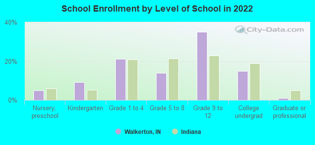
Public high school in Walkerton:
- JOHN GLENN HIGH SCHOOL (Students: 609, Location: 201 JOHN GLENN DR, Grades: 9-12)
Public elementary/middle schools in Walkerton:
- WALKERTON ELEMENTARY SCHOOL (Students: 421, Location: 805 WASHINGTON ST, Grades: PK-6)
- HAROLD C UREY MIDDLE SCHOOL (Students: 291, Location: 407 WASHINGTON ST, Grades: 7-8)
Points of interest:
Notable location: Walkerton Fire Department (A). Display/hide its location on the map
Hotel: Bel-Air Motel (19893 West US Highway 6).
Birthplace of: Harold Urey - Nobel laureate, Chad Blount - Busch series NASCAR driver (born: Sep 4, 1979), Walter LaFeber - Historian.
Drinking water stations with addresses in Walkerton and their reported violations in the past:
HOLSTON RENTALS (Population served: 60, Groundwater):Past monitoring violations:
- 21 regular monitoring violations
| This town: | 2.7 people |
| Indiana: | 2.5 people |
| This town: | 71.6% |
| Whole state: | 66.9% |
| This town: | 6.8% |
| Whole state: | 6.9% |
Likely homosexual households (counted as self-reported same-sex unmarried-partner households)
- Lesbian couples: 0.7% of all households
- Gay men: 0.0% of all households
108 people in nursing homes in 2000
Banks with branches in Walkerton (2011 data):
- 1st Source Bank: Walkerton Branch at 411 Illinois Street, branch established on 1932/07/01. Info updated 2008/06/16: Bank assets: $4,361.6 mil, Deposits: $3,520.6 mil, headquarters in South Bend, IN, positive income, Commercial Lending Specialization, 79 total offices, Holding Company: 1st Source Corporation
For population 15 years and over in Walkerton:
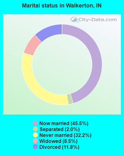
- Never married: 32.2%
- Now married: 45.5%
- Separated: 2.0%
- Widowed: 8.5%
- Divorced: 11.8%
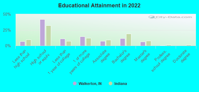
For population 25 years and over in Walkerton:
- High school or higher: 93.0%
- Bachelor's degree or higher: 18.5%
- Graduate or professional degree: 7.4%
- Unemployed: 4.8%
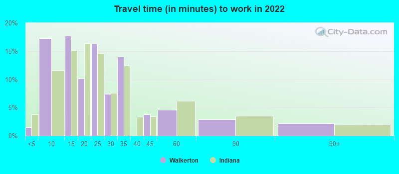
- Mean travel time to work (commute): 28.9 minutes
| Here: | 8.0 |
| Indiana average: | 11.3 |
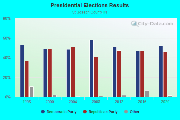
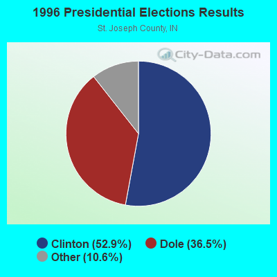
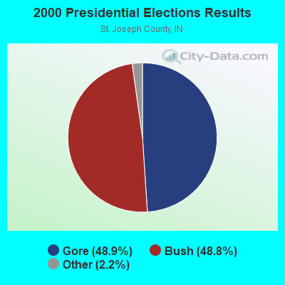


Graphs represent county-level data. Detailed 2008 Election Results
Religion statistics for Walkerton, IN (based on St. Joseph County data)
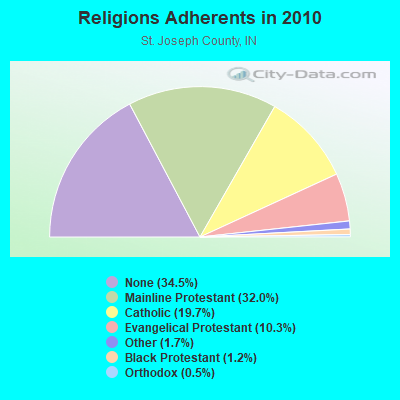
| Religion | Adherents | Congregations |
|---|---|---|
| Mainline Protestant | 85,517 | 64 |
| Catholic | 52,666 | 30 |
| Evangelical Protestant | 27,567 | 140 |
| Other | 4,650 | 21 |
| Black Protestant | 3,300 | 15 |
| Orthodox | 1,226 | 3 |
| None | 92,005 | - |
Food Environment Statistics:
| Here: | 1.39 / 10,000 pop. |
| Indiana: | 1.73 / 10,000 pop. |
| This county: | 0.26 / 10,000 pop. |
| Indiana: | 0.21 / 10,000 pop. |
| St. Joseph County: | 0.79 / 10,000 pop. |
| State: | 0.50 / 10,000 pop. |
| This county: | 2.37 / 10,000 pop. |
| Indiana: | 3.57 / 10,000 pop. |
| St. Joseph County: | 7.79 / 10,000 pop. |
| Indiana: | 6.78 / 10,000 pop. |
| Here: | 9.4% |
| Indiana: | 9.2% |
| St. Joseph County: | 29.5% |
| State: | 29.0% |
| This county: | 13.0% |
| Indiana: | 14.3% |
Health and Nutrition:
| Here: | 62.0% |
| State: | 49.3% |
| Walkerton: | 66.0% |
| State: | 46.2% |
| This city: | 27.0 |
| State: | 28.7 |
| Walkerton: | 15.9% |
| Indiana: | 21.3% |
| Walkerton: | 5.5% |
| State: | 10.6% |
| Here: | 7.1 |
| Indiana: | 6.8 |
| This city: | 30.8% |
| State: | 33.9% |
| Here: | 68.9% |
| State: | 56.1% |
| This city: | 83.5% |
| Indiana: | 78.7% |
More about Health and Nutrition of Walkerton, IN Residents
| Local government employment and payroll (March 2022) | |||||
| Function | Full-time employees | Monthly full-time payroll | Average yearly full-time wage | Part-time employees | Monthly part-time payroll |
|---|---|---|---|---|---|
| Police - Other | 6 | $19,095 | $38,190 | 0 | $0 |
| Health | 5 | $21,089 | $50,614 | 2 | $1,422 |
| Fire - Other | 4 | $8,703 | $26,109 | 2 | $2,953 |
| Financial Administration | 4 | $12,292 | $36,876 | 0 | $0 |
| Water Supply | 4 | $13,927 | $41,781 | 0 | $0 |
| Streets and Highways | 3 | $10,872 | $43,488 | 1 | $801 |
| Parks and Recreation | 2 | $4,956 | $29,736 | 0 | $0 |
| Other Government Administration | 2 | $7,436 | $44,616 | 5 | $9,131 |
| Judicial and Legal | 0 | $0 | 2 | $2,218 | |
| Totals for Government | 30 | $98,370 | $39,348 | 12 | $16,525 |
Walkerton government finances - Expenditure in 2021 (per resident):
- Current Operations - Electric Utilities: $3,979,000 ($1912.06)
Water Utilities: $925,000 ($444.50)
Police Protection: $714,000 ($343.10)
Sewerage: $658,000 ($316.19)
Local Fire Protection: $528,000 ($253.72)
Parks and Recreation: $243,000 ($116.77)
Central Staff Services: $187,000 ($89.86)
Financial Administration: $128,000 ($61.51)
Solid Waste Management: $121,000 ($58.15)
Judicial and Legal Services: $79,000 ($37.96)
- General - Interest on Debt: $193,000 ($92.74)
- Other Capital Outlay - Police Protection: $23,000 ($11.05)
- Water Utilities - Interest on Debt: $111,000 ($53.34)
Walkerton government finances - Revenue in 2021 (per resident):
- Charges - Parks and Recreation: $149,000 ($71.60)
Solid Waste Management: $127,000 ($61.03)
Sewerage: $67,000 ($32.20)
- Miscellaneous - General Revenue - Other: $88,000 ($42.29)
Donations From Private Sources: $75,000 ($36.04)
Interest Earnings: $57,000 ($27.39)
Rents: $9,000 ($4.32)
- Revenue - Electric Utilities: $3,907,000 ($1877.46)
Water Utilities: $730,000 ($350.79)
- State Intergovernmental - Highways: $141,000 ($67.76)
General Local Government Support: $9,000 ($4.32)
- Tax - Property: $1,520,000 ($730.42)
Public Utilities Sales: $51,000 ($24.51)
Other License: $6,000 ($2.88)
Other Selective Sales: $3,000 ($1.44)
Walkerton government finances - Debt in 2021 (per resident):
- Long Term Debt - Beginning Outstanding - Unspecified Public Purpose: $7,586,000 ($3645.36)
Outstanding Unspecified Public Purpose: $7,141,000 ($3431.52)
Retired Unspecified Public Purpose: $445,000 ($213.84)
Walkerton government finances - Cash and Securities in 2021 (per resident):
- Other Funds - Cash and Securities: $3,688,000 ($1772.22)
- Sinking Funds - Cash and Securities: $650,000 ($312.35)
| Businesses in Walkerton, IN | ||||
| Name | Count | Name | Count | |
|---|---|---|---|---|
| Ace Hardware | 1 | McDonald's | 1 | |
| CVS | 1 | Subway | 1 | |
| Dairy Queen | 1 | |||
Strongest AM radio stations in Walkerton:
- WDND (1620 AM; 10 kW; SOUTH BEND, IN; Owner: ARTISTIC MEDIA PARTNERS, INC.)
- WSBT (960 AM; 5 kW; SOUTH BEND, IN; Owner: WSBT, INC.)
- WHLY (1580 AM; 10 kW; SOUTH BEND, IN; Owner: TIMES COMMUNICATIONS INC.)
- WLS (890 AM; 50 kW; CHICAGO, IL; Owner: WLS, INC.)
- WOWO (1190 AM; 50 kW; FORT WAYNE, IN; Owner: PATHFINDER COMMUNICATIONS CORPORATION)
- WSCR (670 AM; 50 kW; CHICAGO, IL; Owner: INFINITY BROADCASTING OPERATIONS, INC.)
- WKVI (1520 AM; daytime; 2 kW; KNOX, IN; Owner: KANKAEE VALLEY BROADCASTING CO., INC)
- WGN (720 AM; 50 kW; CHICAGO, IL; Owner: WGN CONTINENTAL BROADCASTING CO.)
- WBBM (780 AM; 50 kW; CHICAGO, IL; Owner: INFINITY BROADCASTING OPERATIONS, INC.)
- WMVP (1000 AM; 50 kW; CHICAGO, IL; Owner: ABC, INC.)
- WYLL (1160 AM; 50 kW; CHICAGO, IL; Owner: SCA LICENSE CORPORATION)
- WTMJ (620 AM; 50 kW; MILWAUKEE, WI; Owner: JOURNAL BROADCAST CORPORATION)
- WNDZ (750 AM; daytime; 5 kW; PORTAGE, IN; Owner: ENTRAVISION HOLDINGS, LLC)
Strongest FM radio stations in Walkerton:
- WZOC (94.3 FM; PLYMOUTH, IN; Owner: PLYMOUTH BROADCASTING, INC.)
- WNSN (101.5 FM; SOUTH BEND, IN; Owner: WSBT, INC.)
- WNDV-FM (92.9 FM; SOUTH BEND, IN; Owner: ARTISTIC MEDIA PARTNERS, INC.)
- WBYT (100.7 FM; ELKHART, IN; Owner: PATHFINDER COMMUNICATIONS CORPORATION)
- W300AL (107.9 FM; MISHAWAKA, IN; Owner: CSN INTERNATIONAL)
- WVPE (88.1 FM; ELKHART, IN; Owner: ELKHART COMMUNITY SCHOOLS CORP.)
- WKVI-FM (99.3 FM; KNOX, IN; Owner: KANKAKEE VALLEY B/CING. CO., INC.)
- W217AT (91.3 FM; PLYMOUTH, IN; Owner: AMERICAN FAMILY ASSOCIATION)
- WHLP (89.9 FM; HANNA, IN; Owner: CSN INTERNATIONAL)
- WLRX (95.7 FM; NAPPANEE, IN; Owner: TALKING STICK COMMUNICATIONS, LLC)
- WSND-FM (88.9 FM; NOTRE DAME, IN; Owner: VOICE OF THE FIGHTING IRISH, INC.)
- WWLV (102.3 FM; NEW CARLISLE, IN; Owner: ARTISTIC MEDIA PARTNERS, INC.)
- WETL (91.7 FM; SOUTH BEND, IN; Owner: SOUTH BEND COMMUNITY SCHOOL CORP.)
- WHME (103.1 FM; SOUTH BEND, IN; Owner: LESEA BROADCASTING CORPORATION)
- WHPZ (96.9 FM; BREMEN, IN; Owner: LESEA BROADCASTING CORPORATION)
- WBEW (89.5 FM; CHESTERTON, IN; Owner: THE WBEZ ALLIANCE, INC.)
- WLJE (105.5 FM; VALPARAISO, IN; Owner: PORTER COUNTY BROADCASTING CORP.)
- W241AD (96.1 FM; SOUTH BEND, IN; Owner: PROGRESSIVE BROADCASTING SYSTEM, INC)
- WFRN-FM (104.7 FM; ELKHART, IN; Owner: PROGRESSIVE BROADCASTING SYSTEM, INC.)
- WZOW (97.7 FM; GOSHEN, IN; Owner: ARTISTIC MEDIA PARTNERS, INC.)
TV broadcast stations around Walkerton:
- WNDU-TV (Channel 16; SOUTH BEND, IN; Owner: MICHIANA TELECASTING CORP.)
- WMWB-LP (Channel 25; SOUTH BEND, IN; Owner: WMWB-TV LIMITED PARTNERSHIP)
- WSBT-TV (Channel 22; SOUTH BEND, IN; Owner: WSBT, INC.)
- WSJV (Channel 28; ELKHART, IN; Owner: WSJV TELEVISION, INC.)
- WNIT (Channel 34; SOUTH BEND, IN; Owner: MICHIANA PUBLIC BROADCASTING CORPORATION)
- WBND-LP (Channel 57; SOUTH BEND, IN; Owner: WBND-TV LIMITED PARTNERSHIP)
- WHME-TV (Channel 46; SOUTH BEND, IN; Owner: LESEA BROADCASTING CORPORATION)
- WRDY-LP (Channel 69; SOUTH BEND, IN; Owner: WEIGEL BROADCASTING COMPANY)
- WYIN (Channel 56; GARY, IN; Owner: NORTHWEST INDIANA PUBLIC BROADCASTING, INC.)
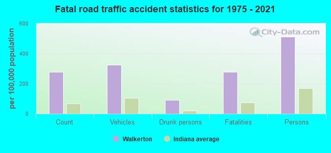
Walkerton fatal accident list:
Oct 4, 2019 11:59 PM, Sr-4, Lat: 41.541500, Lon: -86.487756, Vehicles: 1, Persons: 2, Fatalities: 1, Drunk persons involved: 1
Nov 15, 2012 01:05 AM, Sr-104 S, Us-6 W, Lat: 41.470911, Lon: -86.495831, Vehicles: 1, Persons: 1, Fatalities: 1
Mar 20, 2008 11:13 PM, Walnut, Riley, Lat: 41.505690, Lon: -86.476390, Vehicles: 1, Persons: 2, Fatalities: 1
Apr 17, 1988 02:55 PM, 6, Vehicles: 2, Persons: 4, Fatalities: 1, Drunk persons involved: 1
Jan 14, 1985 12:59 AM, Adams St, Vehicles: 1, Persons: 1, Fatalities: 1
- National Bridge Inventory (NBI) Statistics
- 12Number of bridges
- 79ft / 24.1mTotal length
- $1,990,000Total costs
- 18,203Total average daily traffic
- 1,993Total average daily truck traffic
- 28,557Total future (year 2029) average daily traffic
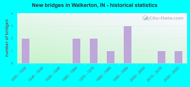
- New bridges - historical statistics
- 21930-1939
- 21960-1969
- 21970-1979
- 11980-1989
- 31990-1999
- 12010-2019
- 12020-2022
FCC Registered Cell Phone Towers:
2 (See the full list of FCC Registered Cell Phone Towers in Walkerton)FCC Registered Antenna Towers:
31 (See the full list of FCC Registered Antenna Towers)FCC Registered Broadcast Land Mobile Towers:
2- 504 Ohio St (Lat: 41.466167 Lon: -86.485833), Call Sign: WXL612,
Assigned Frequencies: 155.205 MHz, Grant Date: 04/04/2023, Expiration Date: 06/15/2033, Registrant: Town Of Walkerton, 504 Washington St, Walkerton, IN 46574, Phone: (574) 586-3511, Email:
- Lat: 41.462000 Lon: -86.493361, Call Sign: WQSW464,
Assigned Frequencies: 456.412 MHz, 457.412 MHz, 462.287 MHz, 452.837 MHz, Grant Date: 11/17/2023, Expiration Date: 11/26/2033, Certifier: Jeffrey Gratrix, Registrant: Atlas License Company & Data Services, 207 North State Street, Box 495, Greenfield, IN 46140, Phone: (317) 813-4865, Fax: (317) 900-7940, Email:
FCC Registered Microwave Towers:
52 (See the full list of FCC Registered Microwave Towers in this town)FCC Registered Amateur Radio Licenses:
49 (See the full list of FCC Registered Amateur Radio Licenses in Walkerton)FAA Registered Aircraft:
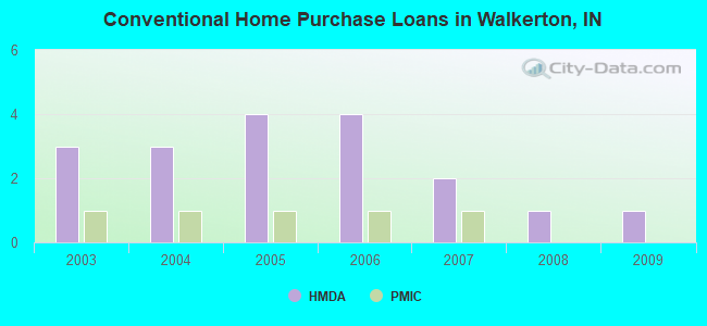
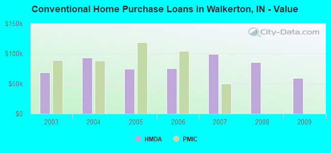
8 (See the full list of FAA Registered Aircraft in Walkerton)| Home Mortgage Disclosure Act Aggregated Statistics For Year 2009 (Based on 1 partial tract) | ||||||||
| A) FHA, FSA/RHS & VA Home Purchase Loans | B) Conventional Home Purchase Loans | C) Refinancings | D) Home Improvement Loans | |||||
|---|---|---|---|---|---|---|---|---|
| Number | Average Value | Number | Average Value | Number | Average Value | Number | Average Value | |
| LOANS ORIGINATED | 1 | $66,180 | 1 | $59,480 | 6 | $89,285 | 1 | $23,940 |
| APPLICATIONS APPROVED, NOT ACCEPTED | 0 | $0 | 0 | $0 | 0 | $0 | 0 | $0 |
| APPLICATIONS DENIED | 0 | $0 | 0 | $0 | 3 | $73,640 | 0 | $0 |
| APPLICATIONS WITHDRAWN | 0 | $0 | 0 | $0 | 1 | $137,260 | 0 | $0 |
| FILES CLOSED FOR INCOMPLETENESS | 0 | $0 | 0 | $0 | 0 | $0 | 0 | $0 |
Detailed HMDA statistics for the following Tracts: 0122.00
| Private Mortgage Insurance Companies Aggregated Statistics For Year 2008 (Based on 1 partial tract) | ||
| B) Refinancings | ||
|---|---|---|
| Number | Average Value | |
| LOANS ORIGINATED | 1 | $65,930 |
| APPLICATIONS APPROVED, NOT ACCEPTED | 0 | $0 |
| APPLICATIONS DENIED | 0 | $0 |
| APPLICATIONS WITHDRAWN | 0 | $0 |
| FILES CLOSED FOR INCOMPLETENESS | 0 | $0 |
Detailed PMIC statistics for the following Tracts: 0122.00
2002 - 2018 National Fire Incident Reporting System (NFIRS) incidents
- Fire incident types reported to NFIRS in Walkerton, IN
- 46947.5%Outside Fires
- 36937.4%Structure Fires
- 11211.3%Mobile Property/Vehicle Fires
- 373.7%Other
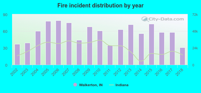 Based on the data from the years 2002 - 2018 the average number of fires per year is 58. The highest number of fire incidents - 79 took place in 2006, and the least - 31 in 2018. The data has a declining trend.
 When looking into fire subcategories, the most reports belonged to: Outside Fires (47.5%), and Structure Fires (37.4%).
- 84.7%Utility gas
- 12.8%Electricity
- 1.1%Other fuel
- 0.9%Bottled, tank, or LP gas
- 0.5%Fuel oil, kerosene, etc.
- 82.2%Utility gas
- 11.4%Electricity
- 4.3%Fuel oil, kerosene, etc.
- 2.2%Bottled, tank, or LP gas
Walkerton compared to Indiana state average:
- Unemployed percentage below state average.
- Black race population percentage significantly below state average.
- Hispanic race population percentage significantly below state average.
- Foreign-born population percentage significantly below state average.
- Length of stay since moving in above state average.
- House age above state average.
- Institutionalized population percentage above state average.

|
|
Total of 24 patent applications in 2008-2024.