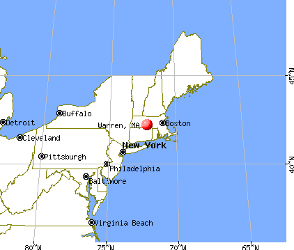
Warren, Massachusetts
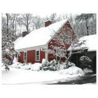
Warren: Colonial Cape on Southbridge Rd
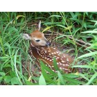
Warren: Spring Fawn
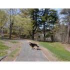
Warren: Amanda in the woods of Warren
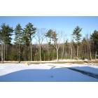
Warren: Warren In Winter Time
- add
your
Submit your own pictures of this place and show them to the world
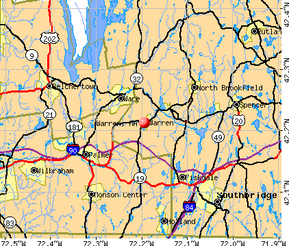
- OSM Map
- General Map
- Google Map
- MSN Map
Population change since 2000: -3.2%
| Males: 701 | |
| Females: 704 |
| Median resident age: | 30.2 years |
| Massachusetts median age: | 40.3 years |
| Warren: | |
| MA: |
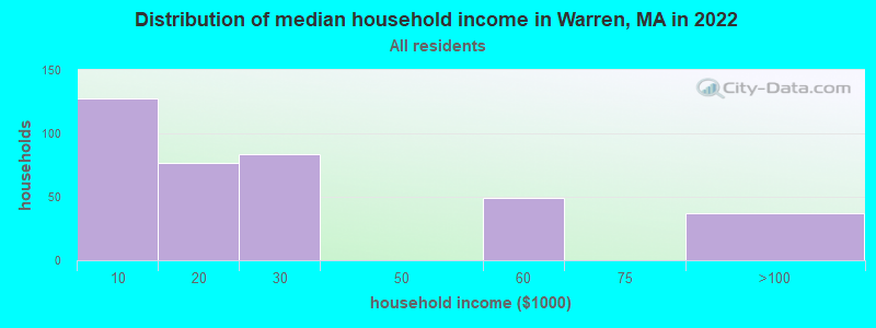
Estimated per capita income in 2022: $16,543 (it was $15,959 in 2000)
Warren CDP income, earnings, and wages data
Estimated median house or condo value in 2022: $-722,834,067 (it was $98,800 in 2000)
| Warren: | |
| MA: |
Mean prices in 2022: all housing units: $271,972; detached houses: $269,519
Median gross rent in 2022: $1,059.
Detailed information about poverty and poor residents in Warren, MA
Compare current foreclosures near Warren, MA:
| Photo | Address | Area | Beds / Baths | Price | Details |
|---|---|---|---|---|---|

|
#1
Old West Brookfield Road
Warren, MA 01083
|
1,760 sq. feet
|
2 baths 4 beds |
show details | |

|
#2
Nelson Street
Warren, MA 01083
|
- sq. feet
|
2 baths 3 beds |
show details | |

|
#3
Washington St
Warren, MA 01083
|
1,864 sq. feet
|
2 baths 3 beds |
show details | |

|
#4
Old West Brookfield Rd
Warren, MA 01083
|
- sq. feet
|
- baths - beds |
show details | |

|
#5
Little Rest Rd
Warren, MA 01083
|
- sq. feet
|
- baths - beds |
show details | |

|
#6
East Rd
Warren, MA 01083
|
- sq. feet
|
- baths - beds |
show details | |

|
#7
N Brookfield Rd
Oakham, MA 01068
|
1,078 sq. feet
|
1 baths 2 beds |
$439,900
|
show details |

|
#8
Nelson St
Warren, MA 01083
|
- sq. feet
|
- baths - beds |
show details | |

|
#9
Hardwick Road
Hardwick, MA 01037
|
- sq. feet
|
1 baths 3 beds |
$229,900
|
show details |

|
#10
Main St # 3144
Palmer, MA 01069
|
875 sq. feet
|
1 baths 2 beds |
show details |
| Photo | Address | Area | Beds / Baths | Price | Details |
|---|---|---|---|---|---|

|
#11
Treadwell Ter
Spencer, MA 01562
|
960 sq. feet
|
1 baths 3 beds |
show details | |

|
#12
Colburn Rd
Stafford Springs, CT 06076
|
1,184 sq. feet
|
2 baths 3 beds |
show details | |

|
#13
Stafford St Apt 6
Rochdale, MA 01542
|
1,134 sq. feet
|
2 baths 2 beds |
show details | |

|
#14
Duke St
Ludlow, MA 01056
|
1,251 sq. feet
|
2 baths 2 beds |
show details | |

|
#15
Main St
Palmer, MA 01069
|
1,114 sq. feet
|
2 baths 2 beds |
show details | |

|
#16
Brickyard Rd
Woodstock, CT 06281
|
936 sq. feet
|
2 baths 2 beds |
show details | |

|
#17
S Main St
Palmer, MA 01069
|
1,117 sq. feet
|
2 baths 2 beds |
show details | |

|
#18
Hovey Rd
Monson, MA 01057
|
2,256 sq. feet
|
1 baths 4 beds |
show details | |

|
#19
Henshaw St
Leicester, MA 01524
|
2,252 sq. feet
|
2 baths 4 beds |
show details | |

|
#20
Glenoak Dr
Springfield, MA 01129
|
2,392 sq. feet
|
3 baths 4 beds |
show details |
| Photo | Address | Area | Beds / Baths | Price | Details |
|---|---|---|---|---|---|

|
#21
Woodland Dr
Hampden, MA 01036
|
972 sq. feet
|
1 baths 3 beds |
show details | |

|
#22
Belchertown St
Three Rivers, MA 01080
|
1,304 sq. feet
|
1 baths 3 beds |
show details | |

|
#23
Miller St
Ludlow, MA 01056
|
1,657 sq. feet
|
2 baths 3 beds |
show details | |

|
#24
Stebbins St
Belchertown, MA 01007
|
1,011 sq. feet
|
1 baths 3 beds |
show details | |

|
#25
Laroche St
Ludlow, MA 01056
|
1,321 sq. feet
|
1 baths 3 beds |
show details | |

|
#26
Prince Rd
Southbridge, MA 01550
|
1,008 sq. feet
|
1 baths 2 beds |
show details | |

|
#27
Grove St
Ware, MA 01082
|
1,386 sq. feet
|
3 baths 3 beds |
show details | |

|
#28
Bliss St
Monson, MA 01057
|
3,756 sq. feet
|
2 baths 3 beds |
show details | |

|
#29
Highland Ave
Monson, MA 01057
|
1,204 sq. feet
|
2 baths 3 beds |
show details | |

|
#30
Benefit St
Southbridge, MA 01550
|
1,505 sq. feet
|
2 baths 4 beds |
show details |
| Photo | Address | Area | Beds / Baths | Price | Details |
|---|---|---|---|---|---|

|
#31
Chaffee Rd
Holland, MA 01521
|
1,552 sq. feet
|
1 baths 3 beds |
show details | |

|
#32
Marc Ave
Southbridge, MA 01550
|
960 sq. feet
|
1 baths 3 beds |
show details | |

|
#33
Southbridge Rd Unit 104
Charlton, MA 01507
|
1,266 sq. feet
|
2 baths 2 beds |
show details | |

|
#34
Stafford Rd
Monson, MA 01057
|
1,464 sq. feet
|
1 baths 3 beds |
show details | |

|
#35
Stafford St
Charlton, MA 01507
|
1,056 sq. feet
|
1 baths 3 beds |
show details | |

|
#36
Roberts Park Rd
Holland, MA 01521
|
660 sq. feet
|
1 baths 3 beds |
show details | |

|
#37
Lane Rd
Barre, MA 01005
|
2,346 sq. feet
|
2 baths 2 beds |
show details | |

|
#38
Marmon St
Springfield, MA 01129
|
980 sq. feet
|
1 baths 2 beds |
show details | |

|
#39
South St
Southbridge, MA 01550
|
2,634 sq. feet
|
3 baths 4 beds |
show details | |

|
#40
Nassau Dr
Springfield, MA 01129
|
796 sq. feet
|
1 baths 1 beds |
show details |
| Photo | Address | Area | Beds / Baths | Price | Details |
|---|---|---|---|---|---|

|
#41
East St
Stafford Springs, CT 06076
|
1,566 sq. feet
|
1 baths 2 beds |
show details | |

|
#42
Brookfield Rd
Brimfield, MA 01010
|
1,482 sq. feet
|
3 baths 3 beds |
show details | |

|
#43
Holland Dr
East Longmeadow, MA 01028
|
1,424 sq. feet
|
1 baths 2 beds |
show details | |

|
#44
Redfield Rd
Cherry Valley, MA 01611
|
1,412 sq. feet
|
1 baths 3 beds |
show details | |

|
#45
Hickory Ln
Hampden, MA 01036
|
2,227 sq. feet
|
3 baths 4 beds |
show details | |

|
#46
Nassau Dr # 37
Springfield, MA 01129
|
796 sq. feet
|
1 baths 1 beds |
show details | |

|
#47
Warebrook Vlg
Ware, MA 01082
|
1,344 sq. feet
|
2 baths 3 beds |
show details | |

|
#48
Monson Rd
Wilbraham, MA 01095
|
1,342 sq. feet
|
1 baths 3 beds |
show details | |

|
#49
S Barre Rd
Barre, MA 01005
|
1,640 sq. feet
|
1 baths 3 beds |
show details | |

|
Check over 1 million property listings on Foreclosure.com!
|
browse all offers | |||

According to our research of Massachusetts and other state lists, there were 5 registered sex offenders living in Warren, Massachusetts as of May 31, 2024.
The ratio of all residents to sex offenders in Warren is 247 to 1.
Type |
2009 |
2010 |
2011 |
2012 |
2013 |
2014 |
2017 |
2018 |
2019 |
2020 |
2021 |
2022 |
|---|---|---|---|---|---|---|---|---|---|---|---|---|
| Murders (per 100,000) | 0 (0.0) | 0 (0.0) | 0 (0.0) | 0 (0.0) | 0 (0.0) | 0 (0.0) | 0 (0.0) | 0 (0.0) | 0 (0.0) | 0 (0.0) | 0 (0.0) | 0 (0.0) |
| Rapes (per 100,000) | 1 (19.4) | 2 (38.9) | 0 (0.0) | 0 (0.0) | 2 (38.8) | 1 (19.3) | 7 (135.0) | 1 (19.1) | 0 (0.0) | 2 (38.4) | 0 (0.0) | 1 (20.1) |
| Robberies (per 100,000) | 1 (19.4) | 0 (0.0) | 0 (0.0) | 0 (0.0) | 1 (19.4) | 0 (0.0) | 0 (0.0) | 2 (38.3) | 0 (0.0) | 0 (0.0) | 2 (38.1) | 1 (20.1) |
| Assaults (per 100,000) | 31 (602.4) | 16 (311.6) | 12 (232.3) | 13 (250.1) | 30 (581.6) | 24 (462.3) | 15 (289.2) | 16 (306.0) | 12 (229.8) | 17 (326.7) | 9 (171.4) | 7 (140.9) |
| Burglaries (per 100,000) | 25 (485.8) | 27 (525.8) | 37 (716.2) | 26 (500.2) | 17 (329.6) | 22 (423.8) | 14 (269.9) | 15 (286.9) | 6 (114.9) | 8 (153.8) | 3 (57.1) | 3 (60.4) |
| Thefts (per 100,000) | 50 (971.6) | 47 (915.3) | 45 (871.1) | 43 (827.2) | 39 (756.1) | 42 (809.1) | 37 (713.3) | 32 (612.1) | 22 (421.4) | 11 (211.4) | 17 (323.7) | 8 (161.0) |
| Auto thefts (per 100,000) | 1 (19.4) | 8 (155.8) | 3 (58.1) | 4 (77.0) | 4 (77.5) | 6 (115.6) | 4 (77.1) | 1 (19.1) | 1 (19.2) | 5 (96.1) | 6 (114.2) | 4 (80.5) |
| Arson (per 100,000) | 0 (0.0) | 0 (0.0) | 0 (0.0) | 0 (0.0) | 0 (0.0) | 0 (0.0) | 2 (38.6) | 3 (57.4) | 1 (19.2) | 0 (0.0) | 2 (38.1) | 0 (0.0) |
| City-Data.com crime index | 216.3 | 179.4 | 136.1 | 124.3 | 212.7 | 179.2 | 219.4 | 134.1 | 72.4 | 123.0 | 71.8 | 67.4 |
The City-Data.com crime index weighs serious crimes and violent crimes more heavily. Higher means more crime, U.S. average is 246.1. It adjusts for the number of visitors and daily workers commuting into cities.
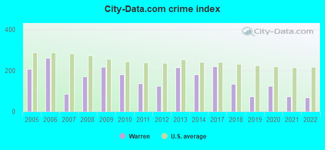
Crime rate in Warren detailed stats: murders, rapes, robberies, assaults, burglaries, thefts, arson
Full-time law enforcement employees in 2021, including police officers: 9 (8 officers - 7 male; 1 female).
| Officers per 1,000 residents here: | 1.52 |
| Massachusetts average: | 2.53 |
 Recent articles from our blog. Our writers, many of them Ph.D. graduates or candidates, create easy-to-read articles on a wide variety of topics.

 | Warren Tavern Charlestown Massachusetts (30 replies) |
| Warren and student loan debt help? (173 replies) |
| Has Elizabeth Warren let you down? (194 replies) |
| Elizabeth Warren is using us as a stepping stone again. (31 replies) |
| Boston crime thread - all posts go here. (2507 replies) |
| Did anyone watch the Warren/ Diehl Debate last night? (147 replies) |
Latest news from Warren, MA collected exclusively by city-data.com from local newspapers, TV, and radio stations
Ancestries: Irish (46.8%), French Canadian (20.9%), American (19.0%), French (13.3%).
Current Local Time: EST time zone
Incorporated in 1742
Elevation: 605 feet
Land area: 1.27 square miles.
Population density: 1,103 people per square mile (low).
61 residents are foreign born (2.9% Europe, 1.3% Latin America).
| This place: | 4.2% |
| Massachusetts: | 12.2% |
| Warren CDP: | 1.6% ($1,532) |
| Massachusetts: | 1.3% ($2,336) |
Nearest city with pop. 50,000+: Springfield, MA  (19.4 miles , pop. 152,082).
Nearest city with pop. 200,000+: Boston, MA (57.1 miles , pop. 589,141).
Nearest city with pop. 1,000,000+: Bronx, NY (128.4 miles , pop. 1,332,650).
Nearest cities:
), ), ), Latitude: 42.21 N, Longitude: 72.19 W
Area code: 413


Single-family new house construction building permits:
- 2022: 16 buildings, average cost: $196,400
- 2021: 12 buildings, average cost: $196,400
- 2020: 6 buildings, average cost: $218,400
- 2019: 6 buildings, average cost: $218,400
- 2018: 3 buildings, average cost: $221,600
- 2017: 10 buildings, average cost: $202,200
- 2016: 3 buildings, average cost: $217,800
- 2015: 3 buildings, average cost: $227,900
- 2014: 5 buildings, average cost: $224,500
- 2013: 3 buildings, average cost: $156,700
- 2012: 4 buildings, average cost: $173,100
- 2011: 1 building, cost: $317,300
- 2010: 4 buildings, average cost: $171,600
- 2009: 4 buildings, average cost: $197,200
- 2008: 5 buildings, average cost: $223,900
- 2007: 14 buildings, average cost: $202,600
- 2006: 20 buildings, average cost: $198,600
- 2005: 43 buildings, average cost: $168,800
- 2004: 44 buildings, average cost: $117,400
- 2003: 42 buildings, average cost: $107,000
- 2002: 31 buildings, average cost: $108,100
- 2001: 25 buildings, average cost: $124,300
- 1998: 6 buildings, average cost: $125,000
- 1997: 14 buildings, average cost: $112,000
| Here: | 3.6% |
| Massachusetts: | 3.5% |
- Health care (13.9%)
- Construction (12.3%)
- Food & beverage stores (6.9%)
- Educational services (5.5%)
- Textile mills & textile products (5.3%)
- Metal & metal products (5.1%)
- Paper (5.0%)
- Construction (20.8%)
- Metal & metal products (9.7%)
- Paper (9.4%)
- Health care (7.1%)
- Administrative & support & waste management services (6.2%)
- Public administration (4.9%)
- Utilities (4.5%)

- Health care (21.5%)
- Food & beverage stores (12.4%)
- Educational services (11.6%)
- Textile mills & textile products (8.4%)
- Finance & insurance (6.5%)
- Plastics & rubber products (5.5%)
- Accommodation & food services (4.7%)
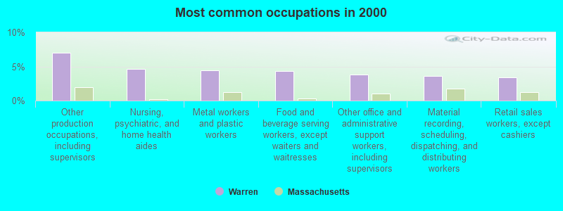
- Other production occupations, including supervisors (7.0%)
- Nursing, psychiatric, and home health aides (4.6%)
- Metal workers and plastic workers (4.5%)
- Food and beverage serving workers, except waiters and waitresses (4.3%)
- Other office and administrative support workers, including supervisors (3.8%)
- Material recording, scheduling, dispatching, and distributing workers (3.6%)
- Retail sales workers, except cashiers (3.4%)
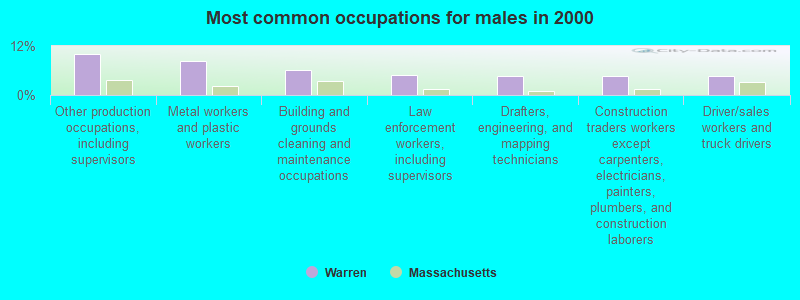
- Other production occupations, including supervisors (10.1%)
- Metal workers and plastic workers (8.4%)
- Building and grounds cleaning and maintenance occupations (6.2%)
- Law enforcement workers, including supervisors (4.9%)
- Drafters, engineering, and mapping technicians (4.5%)
- Construction traders workers except carpenters, electricians, painters, plumbers, and construction laborers (4.5%)
- Driver/sales workers and truck drivers (4.5%)
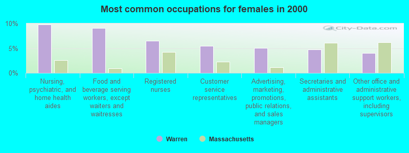
- Nursing, psychiatric, and home health aides (9.8%)
- Food and beverage serving workers, except waiters and waitresses (9.1%)
- Registered nurses (6.5%)
- Customer service representatives (5.5%)
- Advertising, marketing, promotions, public relations, and sales managers (5.1%)
- Secretaries and administrative assistants (4.7%)
- Other office and administrative support workers, including supervisors (4.0%)
Average climate in Warren, Massachusetts
Based on data reported by over 4,000 weather stations


(lower is better)
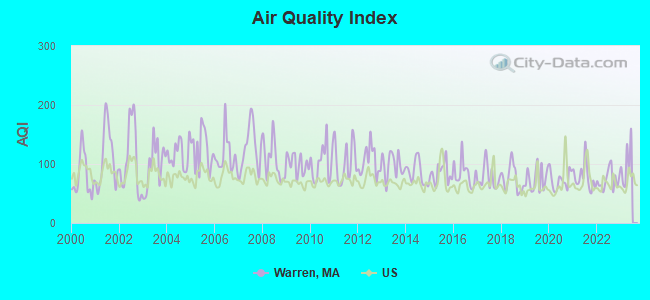
Air Quality Index (AQI) level in 2022 was 72.8. This is about average.
| City: | 72.8 |
| U.S.: | 72.6 |
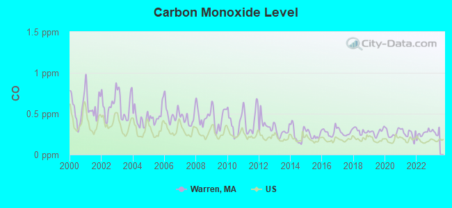
Carbon Monoxide (CO) [ppm] level in 2022 was 0.259. This is about average. Closest monitor was 16.2 miles away from the city center.
| City: | 0.259 |
| U.S.: | 0.251 |
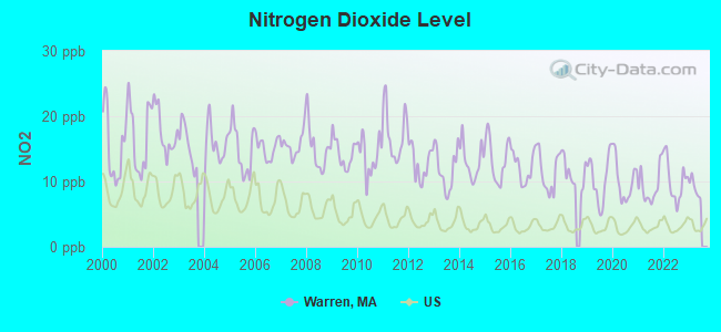
Nitrogen Dioxide (NO2) [ppb] level in 2022 was 10.1. This is significantly worse than average. Closest monitor was 16.2 miles away from the city center.
| City: | 10.1 |
| U.S.: | 5.1 |
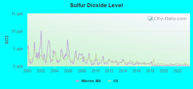
Sulfur Dioxide (SO2) [ppb] level in 2022 was 0.228. This is significantly better than average. Closest monitor was 9.3 miles away from the city center.
| City: | 0.228 |
| U.S.: | 1.515 |
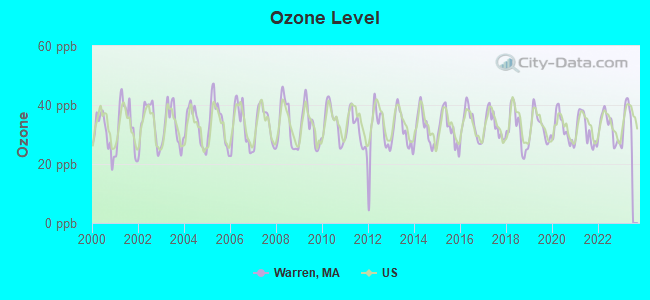
Ozone [ppb] level in 2022 was 32.4. This is about average. Closest monitor was 9.3 miles away from the city center.
| City: | 32.4 |
| U.S.: | 33.3 |

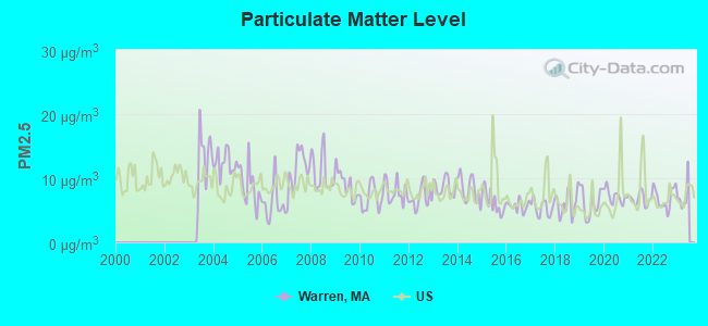
Particulate Matter (PM2.5) [µg/m3] level in 2022 was 6.94. This is about average. Closest monitor was 9.3 miles away from the city center.
| City: | 6.94 |
| U.S.: | 8.11 |
Tornado activity:
Warren-area historical tornado activity is above Massachusetts state average. It is 12% smaller than the overall U.S. average.
On 6/9/1953, a category F4 (max. wind speeds 207-260 mph) tornado 17.8 miles away from the Warren place center killed 90 people and injured 1228 people and caused between $50,000,000 and $500,000,000 in damages.
On 10/3/1979, a category F4 tornado 28.3 miles away from the place center killed 3 people and injured 500 people and caused between $50,000,000 and $500,000,000 in damages.
Earthquake activity:
Warren-area historical earthquake activity is significantly above Massachusetts state average. It is 71% smaller than the overall U.S. average.On 10/7/1983 at 10:18:46, a magnitude 5.3 (5.1 MB, 5.3 LG, 5.1 ML, Class: Moderate, Intensity: VI - VII) earthquake occurred 162.0 miles away from Warren center
On 4/20/2002 at 10:50:47, a magnitude 5.3 (5.3 ML, Depth: 3.0 mi) earthquake occurred 176.1 miles away from the city center
On 4/20/2002 at 10:50:47, a magnitude 5.2 (5.2 MB, 4.2 MS, 5.2 MW, 5.0 MW) earthquake occurred 175.0 miles away from Warren center
On 1/19/1982 at 00:14:42, a magnitude 4.7 (4.5 MB, 4.7 MD, 4.5 LG, Class: Light, Intensity: IV - V) earthquake occurred 94.0 miles away from Warren center
On 10/16/2012 at 23:12:25, a magnitude 4.7 (4.7 ML, Depth: 10.0 mi) earthquake occurred 123.4 miles away from Warren center
On 10/2/1994 at 11:27:22, a magnitude 3.7 (3.5 LG, 3.7 LG, Depth: 6.2 mi, Class: Light, Intensity: II - III) earthquake occurred 10.2 miles away from the city center
Magnitude types: regional Lg-wave magnitude (LG), body-wave magnitude (MB), duration magnitude (MD), local magnitude (ML), surface-wave magnitude (MS), moment magnitude (MW)
Natural disasters:
The number of natural disasters in Worcester County (27) is a lot greater than the US average (15).Major Disasters (Presidential) Declared: 15
Emergencies Declared: 12
Causes of natural disasters: Floods: 9, Storms: 8, Hurricanes: 6, Snowstorms: 5, Winter Storms: 4, Blizzards: 2, Snows: 2, Fire: 1, Heavy Rain: 1, Snowfall: 1, Tornado: 1, Wind: 1 (Note: some incidents may be assigned to more than one category).

Hospitals and medical centers near Warren:
- GUARDIAN HOSPICE OF MASSACHUSETTS, INC (Hospital, about 4 miles away; WEST BROOKFIELD, MA)
- QUABOAG REHABILITATION AND SKILLED CARE CENTER (Nursing Home, about 4 miles away; WEST BROOKFIELD, MA)
- BAYSTATE MARY LANE HOSPITAL Acute Care Hospitals (about 4 miles away; WARE, MA)
- PALMER HEALTHCARE CENTER (Nursing Home, about 8 miles away; PALMER, MA)
- MONSON DEVELOPMENTAL CENTER (Hospital, about 9 miles away; PALMER, MA)
- FMC DIALYSIS SERVICES OF PALMER (Dialysis Facility, about 9 miles away; PALMER, MA)
- WING MEMORIAL HOSPITAL AND MEDICAL CENTER Acute Care Hospitals (about 9 miles away; PALMER, MA)
Colleges/universities with over 2000 students nearest to Warren:
- Western New England University (about 18 miles; Springfield, MA; Full-time enrollment: 3,477)
- Worcester State University (about 19 miles; Worcester, MA; FT enrollment: 5,426)
- Clark University (about 20 miles; Worcester, MA; FT enrollment: 3,687)
- Assumption College (about 20 miles; Worcester, MA; FT enrollment: 2,580)
- Mount Holyoke College (about 20 miles; South Hadley, MA; FT enrollment: 2,573)
- College of the Holy Cross (about 20 miles; Worcester, MA; FT enrollment: 3,125)
- American International College (about 20 miles; Springfield, MA; FT enrollment: 2,733)
Private high school in Warren:
Public elementary/middle school in Warren:
- WARREN ELEMENTARY (Students: 529, Location: 51 SCHOOLHOUSE DRIVE, Grades: PK-6)
Points of interest:
Notable locations in Warren: Warren Fire Department Ambulance (A), Warren Fire Department Station 1 Headquarters (B). Display/hide their locations on the map
Cemetery: Pine Grove Cemetery (1). Display/hide its location on the map
Birthplace of: Fred Dawson - Football, Dennis C. Haley - University President.
Drinking water stations with addresses in Warren and their reported violations in the past:
WARREN WATER DISTRICT (Population served: 2,278, Groundwater):Past health violations:Past monitoring violations:
- MCL, Monthly (TCR) - In SEP-2011, Contaminant: Coliform. Follow-up actions: St AO (w/o penalty) issued (NOV-07-2011)
- MCL, Monthly (TCR) - In AUG-2011, Contaminant: Coliform. Follow-up actions: St AO (w/o penalty) issued (SEP-23-2011)
- MCL, Monthly (TCR) - In SEP-2009, Contaminant: Coliform. Follow-up actions: St AO (w/o penalty) issued (DEC-14-2009)
- MCL, Monthly (TCR) - In MAY-2009, Contaminant: Coliform. Follow-up actions: St AO (w/o penalty) issued (DEC-14-2009)
- Monitoring, Source Water (GWR) - In AUG-01-2011, Contaminant: E. COLI. Follow-up actions: St AO (w/o penalty) issued (SEP-23-2011)
| This place: | 2.4 people |
| Massachusetts: | 2.5 people |
| This place: | 61.6% |
| Whole state: | 63.0% |
| This place: | 11.6% |
| Whole state: | 7.0% |
Likely homosexual households (counted as self-reported same-sex unmarried-partner households)
- Lesbian couples: 0.5% of all households
- Gay men: 0.5% of all households
Banks with branches in Warren (2011 data):
- Spencer Savings Bank: Warren Branch at 968 Main St., branch established on 1882/01/01. Info updated 2008/03/03: Bank assets: $375.2 mil, Deposits: $295.7 mil, headquarters in Spencer, MA, positive income, Mortgage Lending Specialization, 5 total offices, Holding Company: Spencer Mhc
For population 15 years and over in Warren:
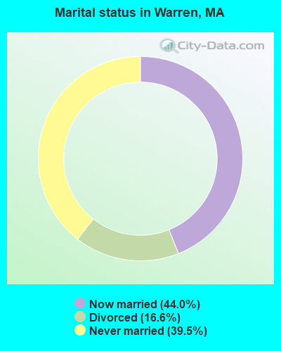
- Never married: 39.5%
- Now married: 44.0%
- Separated: 0.0%
- Widowed: 0.0%
- Divorced: 16.6%
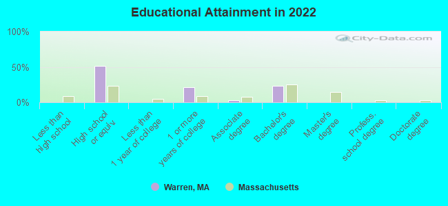
For population 25 years and over in Warren:
- High school or higher: 100.0%
- Bachelor's degree or higher: 24.9%
- Graduate or professional degree: 0.0%
- Unemployed: 8.8%
- Mean travel time to work (commute): 40.7 minutes

| Here: | 6.5 |
| Massachusetts average: | 13.0 |


Graphs represent county-level data. Detailed 2008 Election Results
Religion statistics for Warren, MA (based on Worcester County data)


| Religion | Adherents | Congregations |
|---|---|---|
| Catholic | 306,925 | 118 |
| Mainline Protestant | 43,326 | 171 |
| Evangelical Protestant | 37,511 | 203 |
| Other | 18,931 | 69 |
| Orthodox | 7,935 | 15 |
| Black Protestant | 497 | 6 |
| None | 383,427 | - |
Food Environment Statistics:
| This county: | 1.73 / 10,000 pop. |
| State: | 1.98 / 10,000 pop. |
| Here: | 0.05 / 10,000 pop. |
| Massachusetts: | 0.05 / 10,000 pop. |
| Worcester County: | 1.79 / 10,000 pop. |
| Massachusetts: | 2.22 / 10,000 pop. |
| Worcester County: | 2.22 / 10,000 pop. |
| Massachusetts: | 1.77 / 10,000 pop. |
| Worcester County: | 7.27 / 10,000 pop. |
| Massachusetts: | 8.76 / 10,000 pop. |
| Worcester County: | 8.0% |
| Massachusetts: | 8.1% |
| Worcester County: | 24.0% |
| Massachusetts: | 22.5% |
| Worcester County: | 16.6% |
| Massachusetts: | 16.5% |
Health and Nutrition:
| Warren: | 46.4% |
| Massachusetts: | 50.5% |
| Warren: | 50.3% |
| State: | 48.0% |
| This city: | 30.2 |
| State: | 28.4 |
| This city: | 22.8% |
| State: | 20.7% |
| Warren: | 20.3% |
| Massachusetts: | 10.4% |
| This city: | 6.7 |
| Massachusetts: | 6.8 |
| Here: | 48.7% |
| Massachusetts: | 33.4% |
| Warren: | 50.9% |
| Massachusetts: | 57.1% |
| Warren: | 80.6% |
| Massachusetts: | 79.2% |
More about Health and Nutrition of Warren, MA Residents
4.71% of this county's 2021 resident taxpayers lived in other counties in 2020 ($76,229 average adjusted gross income)
| Here: | 4.71% |
| Massachusetts average: | 6.35% |
0.02% of residents moved from foreign countries ($100 average AGI)
Worcester County: 0.02% Massachusetts average: 0.01%
Top counties from which taxpayers relocated into this county between 2020 and 2021:
| from Middlesex County, MA | |
| from Norfolk County, MA | |
| from Suffolk County, MA |
4.84% of this county's 2020 resident taxpayers moved to other counties in 2021 ($87,252 average adjusted gross income)
| Here: | 4.84% |
| Massachusetts average: | 7.18% |
0.03% of residents moved to foreign countries ($199 average AGI)
Worcester County: 0.03% Massachusetts average: 0.02%
Top counties to which taxpayers relocated from this county between 2020 and 2021:
| to Middlesex County, MA | |
| to Norfolk County, MA | |
| to Suffolk County, MA |
Strongest AM radio stations in Warren:
- WVNE (760 AM; daytime; 25 kW; LEICESTER, MA; Owner: BLOUNT MASSCOM, INC.)
- WARE (1250 AM; 5 kW; WARE, MA; Owner: SUCCESS SIGNAL BROADCASTING, INC.)
- WCRN (830 AM; 50 kW; WORCESTER, MA; Owner: CARTER BROADCASTING CORPORATION)
- WNNZ (640 AM; 50 kW; WESTFIELD, MA; Owner: CLEAR CHANNEL BROADCASTING LICENSES, INC.)
- WALE (990 AM; 50 kW; GREENVILLE, RI; Owner: NORTH AMERICAN BROADCASTING CO., INC.)
- WKOX (1200 AM; 50 kW; FRAMINGHAM, MA; Owner: CAPSTAR TX LIMITED PARTNERSHIP)
- WEEI (850 AM; 50 kW; BOSTON, MA; Owner: ENTERCOM BOSTON LICENSE, LLC)
- WRKO (680 AM; 50 kW; BOSTON, MA; Owner: ENTERCOM BOSTON LICENSE, LLC)
- WTIC (1080 AM; 50 kW; HARTFORD, CT; Owner: INFINITY RADIO OPERATIONS INC.)
- WBIX (1060 AM; 40 kW; NATICK, MA; Owner: LANGER BROADCASTING CORPORATION)
- WTAG (580 AM; 5 kW; WORCESTER, MA; Owner: CAPSTAR TX LIMITED PARTNERSHIP)
- WAMG (890 AM; 25 kW; DEDHAM, MA; Owner: MEGA COMMUNICATIONS OF DEDHAM LICENSEE, LLC)
- WACE (730 AM; 5 kW; CHICOPEE, MA; Owner: CARTER BROADCASTING CORP.)
Strongest FM radio stations in Warren:
- WAAF (107.3 FM; WORCESTER, MA; Owner: ENTERCOM BOSTON LICENSE, LLC)
- WFCR (88.5 FM; AMHERST, MA; Owner: UNIVERSITY OF MASSACHUSETTS)
- WSRS (96.1 FM; WORCESTER, MA; Owner: CAPSTAR TX LIMITED PARTNERSHIP)
- WAMH (89.3 FM; AMHERST, MA; Owner: TRUSTEES OF AMHERST COLLEGE)
- WHYN-FM (93.1 FM; SPRINGFIELD, MA; Owner: CLEAR CHANNEL BROADCASTING LICENSES, INC.)
- W246AM (97.1 FM; AMHERST, MA; Owner: GREAT NORTHERN RADIO, LLC)
- WRNX (100.9 FM; AMHERST, MA; Owner: WESTERN MASSACHUSETTS RADIO COMPANY)
- WYCM (90.1 FM; CHARLTON, MA; Owner: BAY PATH VOCATIONAL HIGH SCHOOL)
- WWFX (100.1 FM; SOUTHBRIDGE, MA; Owner: CITADEL BROADCASTING COMPANY)
- WBPR (91.9 FM; WORCESTER, MA; Owner: UNIVERSITY OF MASSACHUSETTS)
- WORC-FM (98.9 FM; WEBSTER, MA; Owner: CITADEL BROADCASTING COMPANY)
- WAQY (102.1 FM; SPRINGFIELD, MA; Owner: SAGA COMMUNICATIONS OF NEW ENGLAND, LLC)
- WAMC-FM (90.3 FM; ALBANY, NY; Owner: WAMC)
- WXLO (104.5 FM; FITCHBURG, MA; Owner: CITADEL BROADCASTING COMPANY)
- WFEX (92.1 FM; PETERBOROUGH, NH; Owner: FNX BROADCASTING OF NEW HAMPSHIRE LLC)
- WRCH (100.5 FM; NEW BRITAIN, CT; Owner: INFINITY RADIO OPERATIONS INC.)
- WAHL (99.9 FM; ATHOL, MA; Owner: CITADEL BROADCASTING COMPANY)
- WPKX (97.9 FM; ENFIELD, CT; Owner: CAPSTAR TX LIMITED PARTNERSHIP)
- WICN (90.5 FM; WORCESTER, MA; Owner: WICN PUBLIC RADIO, INC)
- WHUS (91.7 FM; STORRS, CT; Owner: THE BD. OF TRUSTEES, THE UNIV. OF CT)
TV broadcast stations around Warren:
- WYDN (Channel 48; WORCESTER, MA; Owner: EDUCATIONAL PUBLIC TV CORPORATION)
- WUNI (Channel 27; WORCESTER, MA; Owner: ENTRAVISION HOLDINGS, LLC)
- WUTF (Channel 66; MARLBOROUGH, MA; Owner: TELEFUTURA BOSTON LLC)
- WTIC-TV (Channel 61; HARTFORD, CT; Owner: TRIBUNE TELEVISION COMPANY)
- W11BJ (Channel 11; HARTFORD, CT; Owner: COMMUNICATIONS SITE MANAGEMENT LLC)
- WCVB-TV (Channel 5; BOSTON, MA; Owner: WCVB HEARST-ARGYLE TV, INC.)
- WPXQ (Channel 69; BLOCK ISLAND, RI; Owner: OCEAN STATE TELEVISION, L.L.C.)
- WCRN-LP (Channel 34; LEICESTER, MA; Owner: CARTER BROADCASTING CORPORATION)
- WTXX (Channel 20; WATERBURY, CT; Owner: WTXX INC.)
- WUVN (Channel 18; HARTFORD, CT; Owner: ENTRAVISION HOLDINGS, LLC)
- WMFP (Channel 62; LAWRENCE, MA; Owner: WSAH LICENSE, INC.)
- WBZ-TV (Channel 4; BOSTON, MA; Owner: VIACOM INC.)
- WGBX-TV (Channel 44; BOSTON, MA; Owner: WGBH EDUCATIONAL FOUNDATION)
- WSBK-TV (Channel 38; BOSTON, MA; Owner: VIACOM INC.)
- WLVI-TV (Channel 56; CAMBRIDGE, MA; Owner: WLVI, INC.)
- WWLP (Channel 22; SPRINGFIELD, MA; Owner: WWLP BROADCASTING, LLC)
- W67DF (Channel 67; SPRINGFIELD, MA; Owner: TRINITY BROADCASTING NETWORK)
- Warren, Massachusetts
- Fatal accident count32
- Vehicles involved in fatal accidents40
- Fatal accidents involving drunk persons:11
- Fatalities35
- Persons involved in fatal accidents70
- Pedestrians involved in fatal accidents0
- Massachusetts average
- Fatal accident count11911
- Vehicles involved in fatal accidents16484
- Fatal accidents involving drunk persons3860
- Fatalities12813
- Persons involved in fatal accidents27405
- Pedestrians involved in fatal accidents971
- National Bridge Inventory (NBI) Statistics
- 13Number of bridges
- 102ft / 30.7mTotal length
- $22,172,000Total costs
- 135,658Total average daily traffic
- 7,849Total average daily truck traffic
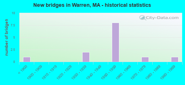
- New bridges - historical statistics
- 1Before 1900
- 21930-1939
- 81950-1959
- 11970-1979
- 11990-1999
FCC Registered Cell Phone Towers:
4 (See the full list of FCC Registered Cell Phone Towers in Warren)FCC Registered Antenna Towers:
43 (See the full list of FCC Registered Antenna Towers)FCC Registered Commercial Land Mobile Towers:
1 (See the full list of FCC Registered Commercial Land Mobile Towers in Warren, MA)FCC Registered Private Land Mobile Towers:
3 (See the full list of FCC Registered Private Land Mobile Towers)FCC Registered Broadcast Land Mobile Towers:
6 (See the full list of FCC Registered Broadcast Land Mobile Towers)FCC Registered Microwave Towers:
10 (See the full list of FCC Registered Microwave Towers in this town)FCC Registered Paging Towers:
6 (See the full list of FCC Registered Paging Towers)FCC Registered Maritime Coast & Aviation Ground Towers:
1 (See the full list of FCC Registered Maritime Coast & Aviation Ground Towers)FCC Registered Amateur Radio Licenses:
30 (See the full list of FCC Registered Amateur Radio Licenses in Warren)FAA Registered Aircraft:
1- Aircraft: AERONCA 7DC (Category: Land, Seats: 2, Weight: Up to 12,499 Pounds, Speed: 90 mph), Engine: CONT MOTOR C85 SERIES (85 HP) (Reciprocating)
N-Number: 1113, N1113, N-1113, Serial Number: 7BCM-89, Airworthiness Date: 05/21/1958, Certificate Issue Date: 08/22/2012
Registrant (Co-Owned): Michael E Spencer, Po Box 880, Warren, MA 01083, Other Owners: Jeffrey A Spencer
| Home Mortgage Disclosure Act Aggregated Statistics For Year 2009 (Based on 1 partial tract) | ||||||||
| A) FHA, FSA/RHS & VA Home Purchase Loans | B) Conventional Home Purchase Loans | C) Refinancings | D) Home Improvement Loans | |||||
|---|---|---|---|---|---|---|---|---|
| Number | Average Value | Number | Average Value | Number | Average Value | Number | Average Value | |
| LOANS ORIGINATED | 1 | $127,660 | 1 | $108,670 | 4 | $160,748 | 1 | $55,630 |
| APPLICATIONS APPROVED, NOT ACCEPTED | 0 | $0 | 0 | $0 | 0 | $0 | 0 | $0 |
| APPLICATIONS DENIED | 0 | $0 | 0 | $0 | 2 | $133,455 | 0 | $0 |
| APPLICATIONS WITHDRAWN | 0 | $0 | 0 | $0 | 1 | $186,770 | 0 | $0 |
| FILES CLOSED FOR INCOMPLETENESS | 0 | $0 | 0 | $0 | 0 | $0 | 0 | $0 |
Detailed HMDA statistics for the following Tracts: 7611.00
| Private Mortgage Insurance Companies Aggregated Statistics For Year 2007 (Based on 1 partial tract) | ||
| A) Conventional Home Purchase Loans | ||
|---|---|---|
| Number | Average Value | |
| LOANS ORIGINATED | 1 | $105,500 |
| APPLICATIONS APPROVED, NOT ACCEPTED | 0 | $0 |
| APPLICATIONS DENIED | 0 | $0 |
| APPLICATIONS WITHDRAWN | 0 | $0 |
| FILES CLOSED FOR INCOMPLETENESS | 0 | $0 |
Detailed PMIC statistics for the following Tracts: 7611.00

2002 - 2018 National Fire Incident Reporting System (NFIRS) incidents
- Fire incident types reported to NFIRS in Warren, MA
- 17043.7%Structure Fires
- 14036.0%Outside Fires
- 7419.0%Mobile Property/Vehicle Fires
- 51.3%Other
 According to the data from the years 2002 - 2018 the average number of fire incidents per year is 23. The highest number of reported fires - 38 took place in 2016, and the least - 9 in 2018. The data has a declining trend.
 When looking into fire subcategories, the most incidents belonged to: Structure Fires (43.7%), and Outside Fires (36.0%).
- 65.1%Utility gas
- 34.9%Wood
- 64.5%Electricity
- 22.3%Utility gas
- 13.1%Fuel oil, kerosene, etc.
Warren compared to Massachusetts state average:
- Median household income significantly below state average.
- Median house value significantly below state average.
- Black race population percentage significantly below state average.
- Hispanic race population percentage significantly below state average.
- Foreign-born population percentage significantly below state average.
- Length of stay since moving in significantly below state average.
- Number of rooms per house significantly below state average.
- House age below state average.
- Number of college students significantly below state average.
Warren on our top lists:
- #34 on the list of "Top 101 cities with the most residents born in Poland (population 500+)"
- #37 on the list of "Top 100 cities with oldest houses"
- #51 on the list of "Top 100 cities with old houses but young residents"
- #4 on the list of "Top 101 counties with the highest carbon monoxide air pollution readings in 2012 (ppm)"
- #5 on the list of "Top 101 counties with the most Catholic congregations"
- #12 on the list of "Top 101 counties with the highest surface withdrawal of fresh water for public supply"
- #16 on the list of "Top 101 counties with the highest total withdrawal of fresh water for public supply"
- #23 on the list of "Top 101 counties with the highest Sulfur Oxides Annual air pollution readings in 2012 (µg/m3)"

|
|
Total of 61 patent applications in 2008-2024.