Waterford, Vermont
Submit your own pictures of this town and show them to the world
- OSM Map
- Google Map
- MSN Map
Population change since 2000: +15.9%
 |
| Males: 637 | |
| Females: 643 |
| Median resident age: | 45.8 years |
| Vermont median age: | 45.8 years |
Zip codes: 05819.
| Waterford: | $90,794 |
| VT: | $73,991 |
Estimated per capita income in 2022: $47,567 (it was $21,762 in 2000)
Waterford town income, earnings, and wages data
Estimated median house or condo value in 2022: $286,018 (it was $111,100 in 2000)
| Waterford: | $286,018 |
| VT: | $304,700 |
Mean prices in 2022: all housing units: $260,980; detached houses: $279,604; townhouses or other attached units: $224,498; in 2-unit structures: $313,991; in 3-to-4-unit structures: $254,854; in 5-or-more-unit structures: $182,529; mobile homes: $88,292; occupied boats, rvs, vans, etc.: $12,813
Detailed information about poverty and poor residents in Waterford, VT
Compare current foreclosures near Waterford, VT:
| Photo | Address | Area | Beds / Baths | Price | Details |
|---|---|---|---|---|---|

|
#1
Scott Hwy
Groton, VT 05046
|
- sq. feet
|
2 baths 3 beds |
$142,500
|
show details |

|
#2
E Main St
Lunenburg, VT 05906
|
- sq. feet
|
- baths - beds |
$19,900
|
show details |

|
#3
Saint Johnsbury Rd
Littleton, NH 03561
|
1,672 sq. feet
|
1 baths 3 beds |
show details | |

|
#4
Jefferson Rd
Whitefield, NH 03598
|
1,769 sq. feet
|
2 baths 3 beds |
show details | |

|
#5
Railroad St Ste 2
Saint Johnsbury, VT 05819
|
- sq. feet
|
- baths - beds |
show details | |

|
#6
Mountain View Dr
Monroe, NH 03771
|
- sq. feet
|
- baths - beds |
show details | |

|
#7
Sugar Hill Rd
Franconia, NH 03580
|
- sq. feet
|
- baths - beds |
show details | |

|
#8
Bishop Rd
Lisbon, NH 03585
|
- sq. feet
|
- baths - beds |
show details | |

|
#9
Maciver Rd
Littleton, NH 03561
|
- sq. feet
|
- baths - beds |
show details | |

|
#10
Washington St
Littleton, NH 03561
|
- sq. feet
|
- baths - beds |
show details |
| Photo | Address | Area | Beds / Baths | Price | Details |
|---|---|---|---|---|---|

|
#11
Adams Dr
Woodsville, NH 03785
|
- sq. feet
|
- baths - beds |
show details | |

|
Check over 1 million property listings on Foreclosure.com!
|
browse all offers | |||

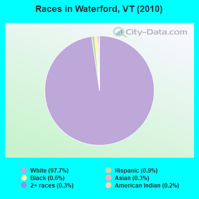
- 1,25097.7%White alone
- 120.9%Hispanic
- 80.6%Black alone
- 40.3%Asian alone
- 40.3%Two or more races
- 20.2%American Indian alone
Races in Waterford detailed stats: ancestries, foreign born residents, place of birth
According to our research of Vermont and other state lists, there were 5 registered sex offenders living in Waterford, Vermont as of May 23, 2024.
The ratio of all residents to sex offenders in Waterford is 256 to 1.
 Recent articles from our blog. Our writers, many of them Ph.D. graduates or candidates, create easy-to-read articles on a wide variety of topics.
Ancestries: English (28.0%), Irish (15.9%), French (14.1%), German (11.6%), French Canadian (10.3%), United States (8.9%).
Current Local Time: EST time zone
Land area: 38.1 square miles.
Population density: 34 people per square mile (very low).
21 residents are foreign born
| This town: | 1.9% |
| Vermont: | 3.8% |
| Waterford town: | 1.6% ($1,758) |
| Vermont: | 2.0% ($2,196) |
Nearest city with pop. 50,000+: Portland, ME  (96.7 miles , pop. 64,249).
Nearest city with pop. 200,000+: Boston, MA (148.0 miles , pop. 589,141).
Nearest city with pop. 1,000,000+: Bronx, NY (262.5 miles , pop. 1,332,650).
Nearest cities:
), ), ), )Latitude: 44.37 N, Longitude: 71.95 W
Area code commonly used in this area: 802

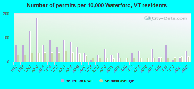
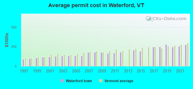
Single-family new house construction building permits:
- 2022: 5 buildings, average cost: $279,200
- 2021: 2 buildings, average cost: $259,200
- 2020: 1 building, cost: $248,200
- 2019: 8 buildings, average cost: $282,200
- 2018: 2 buildings, average cost: $249,800
- 2017: 6 buildings, average cost: $248,100
- 2015: 5 buildings, average cost: $196,000
- 2014: 4 buildings, average cost: $211,200
- 2012: 4 buildings, average cost: $184,000
- 2011: 3 buildings, average cost: $172,800
- 2010: 6 buildings, average cost: $165,900
- 2009: 3 buildings, average cost: $178,900
- 2008: 1 building, cost: $182,400
- 2007: 4 buildings, average cost: $181,200
- 2006: 7 buildings, average cost: $138,800
- 2005: 9 buildings, average cost: $138,800
- 2004: 10 buildings, average cost: $138,800
- 2003: 7 buildings, average cost: $133,900
- 2002: 10 buildings, average cost: $129,800
- 2001: 8 buildings, average cost: $121,400
- 2000: 20 buildings, average cost: $116,700
- 1999: 14 buildings, average cost: $107,600
- 1998: 8 buildings, average cost: $100,500
- 1997: 8 buildings, average cost: $90,100
| Here: | 1.8% |
| Vermont: | 2.0% |

- Health care (13.3%)
- Educational services (10.3%)
- Public administration (6.8%)
- Agriculture, forestry, fishing & hunting (5.5%)
- Construction (5.4%)
- Accommodation & food services (4.0%)
- Administrative & support & waste management services (3.2%)
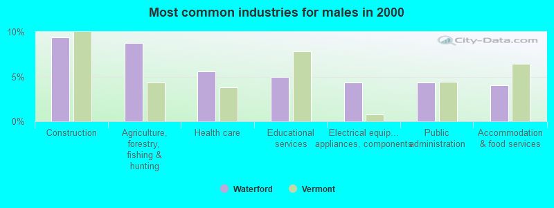
- Construction (9.3%)
- Agriculture, forestry, fishing & hunting (8.7%)
- Health care (5.6%)
- Educational services (5.0%)
- Electrical equipment, appliances, components (4.4%)
- Public administration (4.4%)
- Accommodation & food services (4.0%)
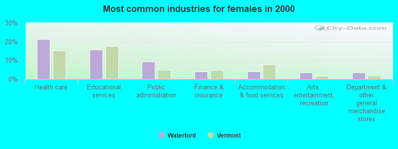
- Health care (21.2%)
- Educational services (15.8%)
- Public administration (9.3%)
- Finance & insurance (3.9%)
- Accommodation & food services (3.9%)
- Arts, entertainment, recreation (3.5%)
- Department & other general merchandise stores (3.5%)
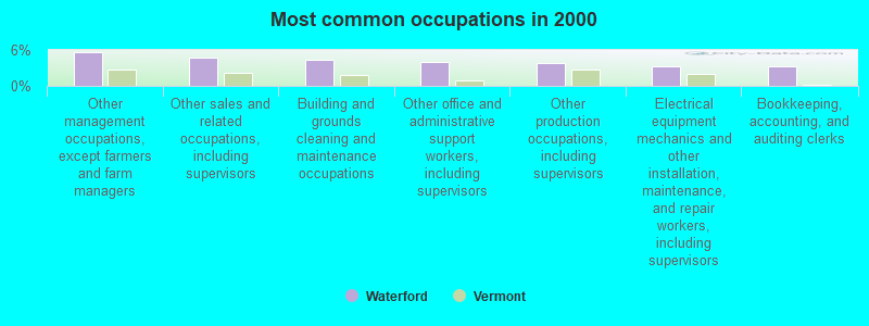
- Other management occupations, except farmers and farm managers (5.7%)
- Other sales and related occupations, including supervisors (4.7%)
- Building and grounds cleaning and maintenance occupations (4.4%)
- Other office and administrative support workers, including supervisors (4.0%)
- Other production occupations, including supervisors (3.8%)
- Electrical equipment mechanics and other installation, maintenance, and repair workers, including supervisors (3.3%)
- Bookkeeping, accounting, and auditing clerks (3.3%)
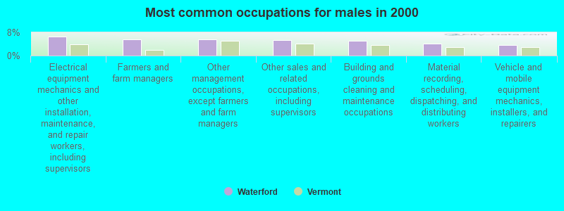
- Electrical equipment mechanics and other installation, maintenance, and repair workers, including supervisors (6.5%)
- Farmers and farm managers (5.6%)
- Other management occupations, except farmers and farm managers (5.6%)
- Other sales and related occupations, including supervisors (5.3%)
- Building and grounds cleaning and maintenance occupations (5.0%)
- Material recording, scheduling, dispatching, and distributing workers (4.0%)
- Vehicle and mobile equipment mechanics, installers, and repairers (3.7%)
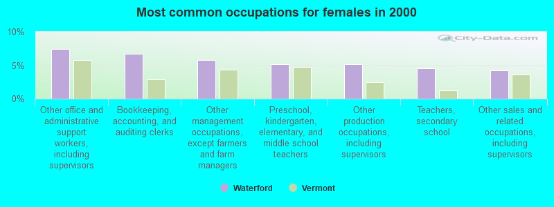
- Other office and administrative support workers, including supervisors (7.4%)
- Bookkeeping, accounting, and auditing clerks (6.8%)
- Other management occupations, except farmers and farm managers (5.8%)
- Preschool, kindergarten, elementary, and middle school teachers (5.1%)
- Other production occupations, including supervisors (5.1%)
- Teachers, secondary school (4.5%)
- Other sales and related occupations, including supervisors (4.2%)
Average climate in Waterford, Vermont
Based on data reported by over 4,000 weather stations


Earthquake activity:
Waterford-area historical earthquake activity is significantly above Vermont state average. It is 72% smaller than the overall U.S. average.On 4/20/2002 at 10:50:47, a magnitude 5.3 (5.3 ML, Depth: 3.0 mi, Class: Moderate, Intensity: VI - VII) earthquake occurred 86.9 miles away from the city center
On 4/20/2002 at 10:50:47, a magnitude 5.2 (5.2 MB, 4.2 MS, 5.2 MW, 5.0 MW) earthquake occurred 87.7 miles away from Waterford center
On 10/7/1983 at 10:18:46, a magnitude 5.3 (5.1 MB, 5.3 LG, 5.1 ML) earthquake occurred 122.1 miles away from Waterford center
On 1/19/1982 at 00:14:42, a magnitude 4.7 (4.5 MB, 4.7 MD, 4.5 LG, Class: Light, Intensity: IV - V) earthquake occurred 62.5 miles away from the city center
On 10/16/2012 at 23:12:25, a magnitude 4.7 (4.7 ML, Depth: 10.0 mi) earthquake occurred 83.6 miles away from the city center
On 6/16/1995 at 12:13:11, a magnitude 3.8 (3.8 LG, Depth: 3.1 mi, Class: Light, Intensity: II - III) earthquake occurred 5.9 miles away from Waterford center
Magnitude types: regional Lg-wave magnitude (LG), body-wave magnitude (MB), duration magnitude (MD), local magnitude (ML), surface-wave magnitude (MS), moment magnitude (MW)
Natural disasters:
The number of natural disasters in Caledonia County (24) is greater than the US average (15).Major Disasters (Presidential) Declared: 21
Emergencies Declared: 1
Causes of natural disasters: Floods: 19, Storms: 16, Heavy Rains: 2, Tropical Storms: 2, Winds: 2, Hurricane: 1, Landslide: 1, Tornado: 1, Winter Storm: 1, Other: 1 (Note: some incidents may be assigned to more than one category).
Hospitals and medical centers near Waterford:
- NORTHEASTERN VERMONT REGIONAL HOSPITAL Critical Access Hospitals (about 7 miles away; SAINT JOHNSBURY, VT)
- ST JOHNSBURY HEALTH AND REHAB (Nursing Home, about 7 miles away; SAINT JOHNSBURY, VT)
- FMC OF ST. JOHNSBURY DIALYSIS (Dialysis Facility, about 7 miles away; SAINT JOHNSBURY, VT)
- CALEDONIA HOME HEALTH CARE (Home Health Center, about 7 miles away; SAINT JOHNSBURY, VT)
- PINES REHAB AND HEALTH CTR (Nursing Home, about 11 miles away; LYNDONVILLE, VT)
- NORTH COUNTRY HOME HEALTH AND HOSPICE AGENCY (Home Health Center, about 11 miles away; LITTLETON, NH)
- LAFAYETTE CENTER, GENESIS HEALTHCARE (Nursing Home, about 14 miles away; FRANCONIA, NH)
Colleges/universities with over 2000 students nearest to Waterford:
- Norwich University (about 39 miles; Northfield, VT; Full-time enrollment: 4,221)
- Plymouth State University (about 45 miles; Plymouth, NH; FT enrollment: 4,838)
- Dartmouth College (about 49 miles; Hanover, NH; FT enrollment: 6,030)
- Saint Michael's College (about 61 miles; Colchester, VT; FT enrollment: 2,336)
- Community College of Vermont (about 62 miles; Winooski, VT; FT enrollment: 3,394)
- University of Vermont (about 63 miles; Burlington, VT; FT enrollment: 11,566)
- Champlain College (about 63 miles; Burlington, VT; FT enrollment: 2,623)
Public elementary/middle school in Waterford:
- WATERFORD ELEMENTARY SCHOOL (Students: 183, Location: 276 DUCK POND ROAD, Grades: PK-8)
Points of interest:
Notable locations in Waterford: Saint Johnsbury Community Correctional Center (A), Waterford Volunteer Fire Department (B). Display/hide their locations on the map
Cemeteries: Cushman Cemetery (1), Hill Cemetery (2), Passumpsic Cemetery (3), Lower Waterford Cemetery (4), Wheeler Cemetery (5), Riverside Cemetery (6), Adams-Babcock Cemetery (7). Display/hide their locations on the map
Lakes and reservoirs: Duck Pond (A), Stiles Pond (B). Display/hide their locations on the map
Streams, rivers, and creeks: Mad Brook (A), Duck Pond Brook (B), Halls Brook (C), Chandler Brook (D). Display/hide their locations on the map
Birthplace of: Lorin Farr - Politician, Jacob Benton - Union Army General.
Drinking water stations with addresses in Waterford and their reported violations in the past:
WATERFORD ELEMENTARY SCHOOL (Address: 276 DUCK POND RD , Population served: 394, Groundwater):Past health violations:PASSUMPSIC FIRE DISTRICT 1 (Address: 34 US ROUTE 5 , Population served: 140, Purch surface water):Past monitoring violations:
- MCL, Monthly (TCR) - In SEP-2012, Contaminant: Coliform. Follow-up actions: St Tech Assistance Visit (SEP-05-2012), St Formal NOV issued (SEP-05-2012), St Public Notif requested (SEP-05-2012), St Boil Water Order (SEP-05-2012), St Compliance achieved (SEP-17-2012)
- Follow-up Or Routine LCR Tap M/R - In JUL-01-2002, Contaminant: Lead and Copper Rule. Follow-up actions: St Public Notif requested (NOV-22-2002), St Formal NOV issued (NOV-22-2002), St Public Notif received (DEC-20-2002), St Compliance achieved (APR-26-2011)
- Follow-up Or Routine LCR Tap M/R - In JUL-01-2002, Contaminant: Lead and Copper Rule
- One minor monitoring violation
- 21 regular monitoring violations
Past health violations:Past monitoring violations:
- MCL, Monthly (TCR) - In SEP-2013, Contaminant: Coliform. Follow-up actions: St Public Notif requested (SEP-10-2013), St Formal NOV issued (SEP-10-2013), St Public Notif received (SEP-23-2013), St Compliance achieved (JAN-17-2014)
- MCL, Monthly (TCR) - In AUG-2013, Contaminant: Coliform. Follow-up actions: St Public Notif requested (AUG-28-2013), St Formal NOV issued (AUG-28-2013), St Public Notif received (SEP-23-2013), St Compliance achieved (JAN-17-2014)
- MCL, Average - Between APR-2010 and JUN-2010, Contaminant: TTHM. Follow-up actions: St Public Notif requested (JUL-14-2010), St Formal NOV issued (JUL-14-2010), St Tech Assistance Visit (JUL-14-2010), St Public Notif received (JAN-26-2011), St Compliance achieved (MAY-17-2013)
- MCL, Average - Between JAN-2010 and MAR-2010, Contaminant: TTHM. Follow-up actions: St Public Notif requested (APR-19-2010), St Tech Assistance Visit (APR-19-2010), St Formal NOV issued (APR-19-2010), St Public Notif received (MAY-10-2010), St Compliance achieved (MAY-17-2013)
- MCL, Average - Between OCT-2009 and DEC-2009, Contaminant: TTHM. Follow-up actions: St Public Notif requested (FEB-02-2010), St Tech Assistance Visit (FEB-02-2010), St Formal NOV issued (FEB-02-2010), St Public Notif received (JAN-26-2011), St Compliance achieved (MAY-17-2013)
- MCL, Average - Between JUL-2009 and SEP-2009, Contaminant: TTHM. Follow-up actions: St Public Notif requested (OCT-14-2009), St Tech Assistance Visit (OCT-14-2009), St Formal NOV issued (OCT-14-2009), St Public Notif received (NOV-10-2009), St Compliance achieved (MAY-17-2013)
- MCL, Average - Between APR-2009 and JUN-2009, Contaminant: TTHM. Follow-up actions: St Public Notif requested (JUL-13-2009), St Tech Assistance Visit (JUL-13-2009), St Formal NOV issued (JUL-13-2009), St Public Notif received (JUL-23-2009), St Compliance achieved (MAY-17-2013)
- Monitoring and Reporting (DBP) - Between APR-2014 and JUN-2014, Contaminant: Chlorine. Follow-up actions: St Formal NOV issued (MAY-30-2014), St Public Notif requested (MAY-30-2014)
- Monitoring and Reporting (DBP) - Between OCT-2013 and DEC-2013, Contaminant: Chlorine. Follow-up actions: St Public Notif requested (DEC-03-2013), St Formal NOV issued (DEC-03-2013), St Compliance achieved (JAN-17-2014)
- Monitoring and Reporting (DBP) - Between OCT-2011 and DEC-2011, Contaminant: Chlorine. Follow-up actions: St Formal NOV issued (FEB-02-2012), St Compliance achieved (FEB-11-2013)
- Monitoring and Reporting (DBP) - Between JUL-2011 and SEP-2011, Contaminant: Chlorine. Follow-up actions: St Public Notif requested (JAN-27-2012), St Formal NOV issued (JAN-27-2012), St Public Notif received (JUN-29-2012), St Compliance achieved (FEB-11-2013)
- Monitoring and Reporting (DBP) - Between JUL-2010 and SEP-2010, Contaminant: Chlorine. Follow-up actions: St Public Notif requested (OCT-07-2010), St Formal NOV issued (OCT-07-2010), St Public Notif received (JAN-26-2011), St Compliance achieved (AUG-10-2011)
- 9 routine major monitoring violations
- One minor monitoring violation
- 14 other older monitoring violations
| This town: | 2.5 people |
| Vermont: | 2.3 people |
| This town: | 76.6% |
| Whole state: | 62.5% |
| This town: | 6.9% |
| Whole state: | 9.2% |
Likely homosexual households (counted as self-reported same-sex unmarried-partner households)
- Lesbian couples: 0.6% of all households
- Gay men: 0.0% of all households
| This town: | 4.2% |
| Whole state: | 9.4% |
| This town: | 1.2% |
| Whole state: | 3.6% |
4 people in group homes intended for adults in 2010
3 people in homes for the mentally retarded in 2000
For population 15 years and over in Waterford:
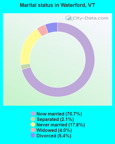
- Never married: 17.8%
- Now married: 70.7%
- Separated: 2.1%
- Widowed: 4.0%
- Divorced: 5.4%
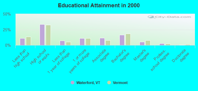
For population 25 years and over in Waterford:
- High school or higher: 88.9%
- Bachelor's degree or higher: 25.9%
- Graduate or professional degree: 9.2%
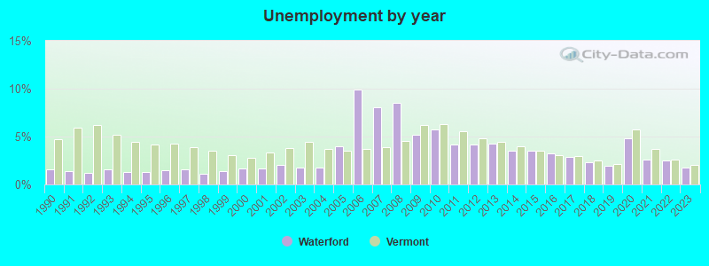
- Unemployed: 2.2%
- Mean travel time to work (commute): 22.9 minutes
| Here: | 10.8 |
| Vermont average: | 11.7 |
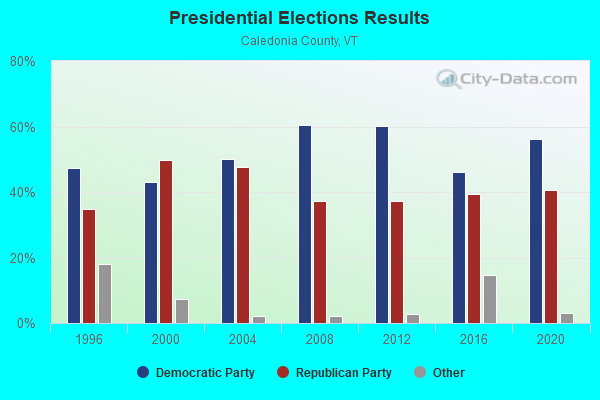
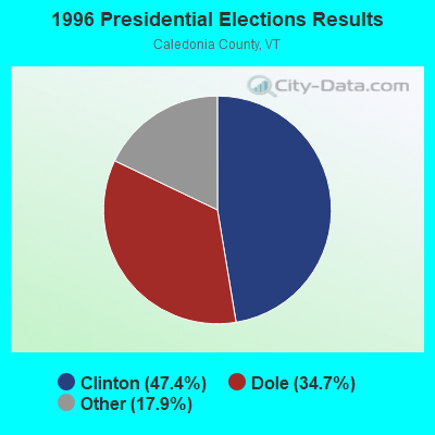
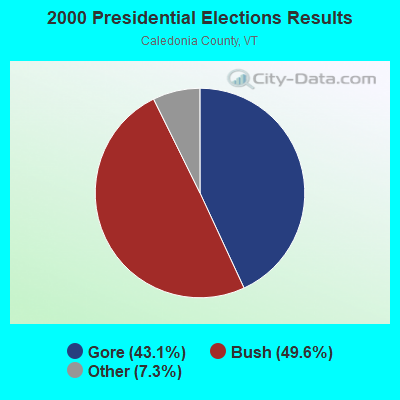
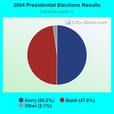
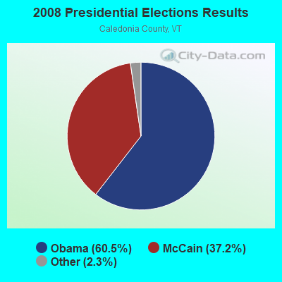
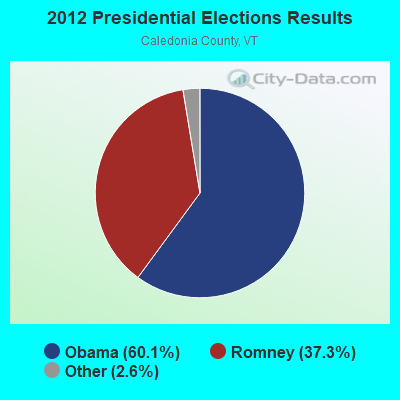
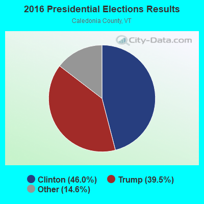
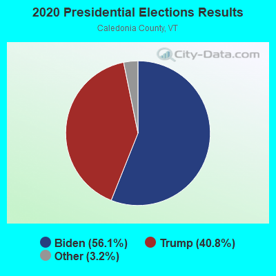
Graphs represent county-level data. Detailed 2008 Election Results
Religion statistics for Waterford, VT (based on Caledonia County data)
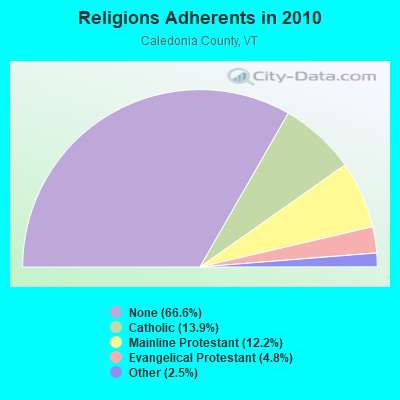
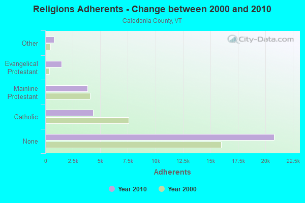
| Religion | Adherents | Congregations |
|---|---|---|
| Catholic | 4,355 | 6 |
| Mainline Protestant | 3,810 | 32 |
| Evangelical Protestant | 1,488 | 15 |
| Other | 780 | 9 |
| None | 20,794 | - |
Food Environment Statistics:
| Caledonia County: | 4.91 / 10,000 pop. |
| Vermont: | 3.84 / 10,000 pop. |
| Caledonia County: | 2.29 / 10,000 pop. |
| Vermont: | 1.95 / 10,000 pop. |
| Here: | 7.53 / 10,000 pop. |
| Vermont: | 6.40 / 10,000 pop. |
| Here: | 10.14 / 10,000 pop. |
| State: | 11.52 / 10,000 pop. |
| This county: | 7.9% |
| Vermont: | 6.8% |
| This county: | 24.6% |
| Vermont: | 22.3% |
| Caledonia County: | 11.5% |
| State: | 13.3% |
Strongest AM radio stations in Waterford:
- WSTJ (1340 AM; 1 kW; ST. JOHNSBURY, VT; Owner: VERMONT BROADCAST ASSOCIATES, INC.)
- WTWN (1100 AM; daytime; 5 kW; WELLS RIVER, VT; Owner: PUFFER BROADCASTING, INC.)
- WLTN (1400 AM; 1 kW; LITTLETON, NH; Owner: PROFILE BROADCASTING COMPANY, INC.)
- WCHP (760 AM; 35 kW; CHAMPLAIN, NY; Owner: CHAMPLAIN RADIO, INC.)
- WDEV (550 AM; 5 kW; WATERBURY, VT; Owner: RADIO VERMONT, INC.)
- WRKO (680 AM; 50 kW; BOSTON, MA; Owner: ENTERCOM BOSTON LICENSE, LLC)
- WNNZ (640 AM; 50 kW; WESTFIELD, MA; Owner: CLEAR CHANNEL BROADCASTING LICENSES, INC.)
- WCRN (830 AM; 50 kW; WORCESTER, MA; Owner: CARTER BROADCASTING CORPORATION)
- WGY (810 AM; 50 kW; SCHENECTADY, NY; Owner: CLEAR CHANNEL BROADCASTING LICENSES, INC.)
- WEEI (850 AM; 50 kW; BOSTON, MA; Owner: ENTERCOM BOSTON LICENSE, LLC)
- WICY (1490 AM; 50 kW; MALONE, NY; Owner: CARTIER COMMUNICATIONS INC.)
- WTME (780 AM; 10 kW; RUMFORD, ME; Owner: MOUNTAIN VALLEY BROADCASTING, INC.)
- WPNH (1300 AM; 5 kW; PLYMOUTH, NH; Owner: NORTHEAST COMMUNICATIONS CORPORATION)
Strongest FM radio stations in Waterford:
- WCKJ (90.5 FM; ST. JOHNSBURY, VT; Owner: CHRISTIAN MINISTRIES, INC.)
- WKXH (105.5 FM; ST. JOHNSBURY, VT; Owner: VERMONT BROADCAST ASSOCIATES, INC.)
- WGMT (97.7 FM; LYNDON, VT; Owner: VERMONT BROADCAST ASSOCIATES, INC.)
- WMTK (106.3 FM; LITTLETON, NH; Owner: VERMONT BROADCAST ASSOCIATES, INC.)
- WPKQ (103.7 FM; NORTH CONWAY, NH; Owner: CITADEL BROADCASTING COMPANY)
- WDOT (95.7 FM; DANVILLE, VT; Owner: MONTPELIER BROADCASTING INC)
- WHOM (94.9 FM; MT. WASHINGTON, NH; Owner: CITADEL BROADCASTING COMPANY)
- WXXS (102.3 FM; LANCASTER, NH; Owner: BARRY P. LUNDERVILLE)
- WLTN-FM (96.7 FM; LISBON, NH; Owner: PROFILE BROADCASTING CO., INC.)
- WVFM (105.7 FM; CAMPTON, NH; Owner: DEVON BROADCASTING COMPANY, INC.)
- WLKC (103.3 FM; WATERBURY, VT; Owner: RADIO BROADCASTING SERVICES, INC.)
- WVPS (107.9 FM; BURLINGTON, VT; Owner: VERMONT PUBLIC RADIO)
- WCVT (101.7 FM; STOWE, VT; Owner: RADIO VERMONT CLASSICS, L.L.C.)
- WEZF (92.9 FM; BURLINGTON, VT; Owner: CAPSTAR TX LIMITED PARTNERSHIP)
- WNCS (104.7 FM; MONTPELIER, VT; Owner: MONTPELIER BROADCASTING, INC.)
- WDEV-FM (96.1 FM; WARREN, VT; Owner: RADIO VERMONT, INC.)
- WSCY (106.9 FM; MOULTONBOROUGH, NH; Owner: NORTHEAST COMMUNICATIONS CORPORATION)
- WEBK (105.3 FM; KILLINGTON, VT; Owner: 6 JOHNSON ROAD LICENSES, INC.)
- WJJR (98.1 FM; RUTLAND, VT; Owner: 6 JOHNSON ROAD LICENSES, INC.)
- WZRT (97.1 FM; RUTLAND, VT; Owner: CAPSTAR TX LIMITED PARTNERSHIP)
TV broadcast stations around Waterford:
- WLED-TV (Channel 49; LITTLETON, NH; Owner: UNIVERSITY OF NEW HAMPSHIRE)
- National Bridge Inventory (NBI) Statistics
- 30Number of bridges
- 410ft / 125mTotal length
- $14,266,000Total costs
- 131,896Total average daily traffic
- 15,876Total average daily truck traffic
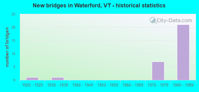
- New bridges - historical statistics
- 11920-1929
- 11930-1939
- 71970-1979
- 211980-1989
FCC Registered Microwave Towers:
1- Waterford-01, 303 Walsh Road (Lat: 44.426444 Lon: -71.929833), Type: Mtower, Structure height: 41.1 m, Call Sign: WQWH863,
Assigned Frequencies: 11385.0 MHz, 11385.0 MHz, 11545.0 MHz, 11585.0 MHz, 11305.0 MHz, 11345.0 MHz, 11385.0 MHz, 11385.0 MHz, 11545.0 MHz, 11585.0 MHz... (+78 more), Grant Date: 08/27/2015, Expiration Date: 08/27/2025, Certifier: Fran Stocker, Registrant: Radyn, Inc, Silver Spring, MD 20914, Phone: (301) 493-5171, Fax: (301) 576-4553, Email:
FCC Registered Amateur Radio Licenses:
5- Call Sign: N1ZOV, Licensee ID: L01297150, Grant Date: 06/08/2017, Expiration Date: 07/07/2027, Certifier: Kevin W Reichert, Registrant: Kevin W Reichert, 2781 Daniels Farm Road, Waterford, VT 05819-9549
- Call Sign: KB1GBH, Licensee ID: L00306604, Grant Date: 12/16/2000, Expiration Date: 12/16/2010, Cancellation Date: 12/18/2012, Certifier: Luke B Stodola, Registrant: Luke B Stodola, 1355 Simpson Brook Road, Waterford, VT 05819
- Call Sign: KB1NGU, Licensee ID: L01131363, Grant Date: 03/21/2006, Expiration Date: 03/21/2016, Cancellation Date: 03/22/2018, Certifier: Robert S Johnston, Registrant: Robert S Johnston, 4 Cortland Hill Rd, Waterford, VT 05819
- Call Sign: KB1RXI, Licensee ID: L01473250, Grant Date: 01/30/2019, Expiration Date: 03/10/2029, Certifier: Michael W Keach, Registrant: Michael W Keach, 595 Old County Rd, Waterford, VT 05819-9514
- Call Sign: KB1ZHS, Licensee ID: L01764475, Grant Date: 12/06/2022, Expiration Date: 02/06/2033, Certifier: Jeffrey M Morris, Registrant: Jeffrey M Morris, 6130 Rt18, Waterford, VT 05819
2002 - 2018 National Fire Incident Reporting System (NFIRS) incidents
- Fire incident types reported to NFIRS in Waterford, VT
- 7945.7%Structure Fires
- 6235.8%Outside Fires
- 3017.3%Mobile Property/Vehicle Fires
- 21.2%Other
 Based on the data from the years 2002 - 2018 the average number of fire incidents per year is 10. The highest number of fire incidents - 23 took place in 2009, and the least - 3 in 2015. The data has a decreasing trend.
 When looking into fire subcategories, the most reports belonged to: Structure Fires (45.7%), and Outside Fires (35.8%).
- 64.1%Fuel oil, kerosene, etc.
- 20.5%Wood
- 11.9%Bottled, tank, or LP gas
- 1.3%Electricity
- 1.0%Utility gas
- 0.8%Coal or coke
- 0.5%Solar energy
- 89.7%Fuel oil, kerosene, etc.
- 10.3%Bottled, tank, or LP gas
Waterford compared to Vermont state average:
- Unemployed percentage significantly below state average.
- Hispanic race population percentage below state average.
- Foreign-born population percentage significantly below state average.
- Renting percentage significantly below state average.
- Length of stay since moving in significantly above state average.
- Number of rooms per house significantly below state average.
- House age significantly below state average.
- Number of college students below state average.

|
Total of 4 patent applications in 2008-2024.