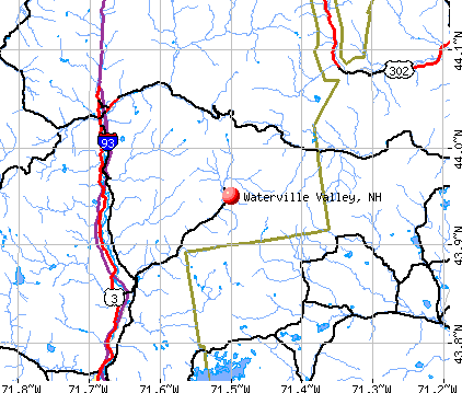
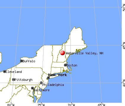
Waterville Valley, New Hampshire
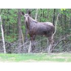
Waterville Valley: MOOSE ON THE LOOSE
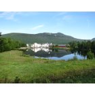
Waterville Valley: EARLY MORNING TOWN SQUARE
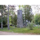
Waterville Valley: STONE TOWER
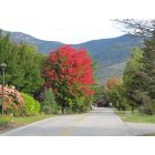
Waterville Valley: APPROACHING FALL
- add
your
Submit your own pictures of this town and show them to the world
- OSM Map
- General Map
- Google Map
- MSN Map
Population change since 2000: -3.9%
 |
| Males: 124 | |
| Females: 123 |
| Median resident age: | 55.3 years |
| New Hampshire median age: | 43.9 years |
Zip codes: 03215.
| Waterville Valley: | $79,024 |
| NH: | $89,992 |
Estimated per capita income in 2022: $60,033 (it was $26,400 in 2000)
Waterville Valley town income, earnings, and wages data
Estimated median house or condo value in 2022: $459,617 (it was $143,800 in 2000)
| Waterville Valley: | $459,617 |
| NH: | $384,700 |
Mean prices in 2022: all housing units: $486,096; detached houses: $533,852; townhouses or other attached units: $375,744; in 2-unit structures: $230,260; in 3-to-4-unit structures: $242,363; in 5-or-more-unit structures: $588,257; mobile homes: $127,035
Waterville Valley, NH residents, houses, and apartments details
Detailed information about poverty and poor residents in Waterville Valley, NH
Compare current foreclosures near Waterville Valley, NH:
| Photo | Address | Area | Beds / Baths | Price | Details |
|---|---|---|---|---|---|

|
#1
Summit View Dr
Moultonborough, NH 03254
|
840 sq. feet
|
2 baths 3 beds |
show details | |

|
#2
Beaver Path
Thornton, NH 03285
|
- sq. feet
|
- baths - beds |
show details | |

|
#3
Summit Dr
Campton, NH 03223
|
- sq. feet
|
- baths - beds |
show details | |

|
#4
Old Colony Rd
Conway, NH 03818
|
- sq. feet
|
- baths - beds |
show details | |

|
#5
Greyhound St
Moultonborough, NH 03254
|
- sq. feet
|
- baths - beds |
show details | |

|
#6
Eastside Rd
North Woodstock, NH 03262
|
- sq. feet
|
- baths - beds |
show details | |

|
#7
Fairgrounds Rd
Plymouth, NH 03264
|
- sq. feet
|
- baths - beds |
show details | |

|
Check over 1 million property listings on Foreclosure.com!
|
browse all offers | |||

- 24298.0%White alone
- 31.2%Two or more races
- 10.4%Black alone
- 10.4%Hispanic

Races in Waterville Valley detailed stats: ancestries, foreign born residents, place of birth
Type |
2009 |
2010 |
2011 |
2012 |
2013 |
2014 |
2015 |
2016 |
2017 |
2018 |
2019 |
2020 |
2021 |
2022 |
|---|---|---|---|---|---|---|---|---|---|---|---|---|---|---|
| Murders (per 100,000) | 0 (0.0) | 0 (0.0) | 0 (0.0) | 0 (0.0) | 0 (0.0) | 0 (0.0) | 0 (0.0) | 0 (0.0) | 0 (0.0) | 0 (0.0) | 0 (0.0) | 0 (0.0) | 0 (0.0) | 0 (0.0) |
| Rapes (per 100,000) | 0 (0.0) | 1 (404.9) | 0 (0.0) | 0 (0.0) | 0 (0.0) | 0 (0.0) | 1 (403.2) | 0 (0.0) | 2 (816.3) | 0 (0.0) | 1 (411.5) | 0 (0.0) | 0 (0.0) | 1 (196.1) |
| Robberies (per 100,000) | 0 (0.0) | 2 (809.7) | 0 (0.0) | 0 (0.0) | 0 (0.0) | 0 (0.0) | 0 (0.0) | 0 (0.0) | 0 (0.0) | 0 (0.0) | 0 (0.0) | 0 (0.0) | 0 (0.0) | 0 (0.0) |
| Assaults (per 100,000) | 0 (0.0) | 0 (0.0) | 0 (0.0) | 1 (406.5) | 0 (0.0) | 0 (0.0) | 0 (0.0) | 1 (406.5) | 0 (0.0) | 0 (0.0) | 0 (0.0) | 0 (0.0) | 0 (0.0) | 0 (0.0) |
| Burglaries (per 100,000) | 2 (738.0) | 0 (0.0) | 2 (809.7) | 5 (2,033) | 7 (2,846) | 12 (4,839) | 2 (806.5) | 1 (406.5) | 1 (408.2) | 2 (826.4) | 0 (0.0) | 0 (0.0) | 0 (0.0) | 0 (0.0) |
| Thefts (per 100,000) | 62 (22,878) | 60 (24,291) | 21 (8,502) | 21 (8,537) | 34 (13,821) | 19 (7,661) | 22 (8,871) | 12 (4,878) | 8 (3,265) | 16 (6,612) | 12 (4,938) | 8 (3,333) | 7 (2,893) | 17 (3,333) |
| Auto thefts (per 100,000) | 1 (369.0) | 0 (0.0) | 0 (0.0) | 1 (406.5) | 2 (813.0) | 0 (0.0) | 2 (806.5) | 0 (0.0) | 0 (0.0) | 1 (413.2) | 0 (0.0) | 0 (0.0) | 0 (0.0) | 0 (0.0) |
| Arson (per 100,000) | 0 (0.0) | 0 (0.0) | 0 (0.0) | 1 (406.5) | 0 (0.0) | 1 (403.2) | 0 (0.0) | 0 (0.0) | 0 (0.0) | 0 (0.0) | 0 (0.0) | 0 (0.0) | 0 (0.0) | 0 (0.0) |
| City-Data.com crime index | 996.3 | 1538.5 | 396.8 | 597.6 | 817.1 | 645.2 | 798.4 | 304.9 | 812.2 | 355.4 | 526.7 | 133.3 | 115.7 | 290.2 |
The City-Data.com crime index weighs serious crimes and violent crimes more heavily. Higher means more crime, U.S. average is 246.1. It adjusts for the number of visitors and daily workers commuting into cities.

Crime rate in Waterville Valley detailed stats: murders, rapes, robberies, assaults, burglaries, thefts, arson
Full-time law enforcement employees in 2021, including police officers: 7 (7 officers - 7 male; 0 female).
| Officers per 1,000 residents here: | 28.93 |
| New Hampshire average: | 2.14 |
 Recent articles from our blog. Our writers, many of them Ph.D. graduates or candidates, create easy-to-read articles on a wide variety of topics.

 | Why Isn't NH Population Booming? (110 replies) |
| New Yorkers Using Ski Condos Year Round Residences? (39 replies) |
| It's snowing right now (18 replies) |
| Ski Resort close to Manchester (8 replies) |
| itinerary for NH vacation (11 replies) |
| Where else to look in NH? (30 replies) |
Latest news from Waterville Valley, NH collected exclusively by city-data.com from local newspapers, TV, and radio stations
Ancestries: Irish (25.3%), English (14.4%), German (5.8%), United States (5.4%), French (4.7%), Italian (4.7%).
Current Local Time: EST time zone
Incorporated in 1829
Elevation: 1519 feet
Land area: 64.9 square miles.
Population density: 3.8 people per square mile (very low).
10 residents are foreign born (3.5% Europe).
| This town: | 3.9% |
| New Hampshire: | 4.4% |
| Waterville Valley town: | 3.6% ($5,192) |
| New Hampshire: | 2.3% ($2,946) |
Nearest city with pop. 50,000+: Portland, ME  (64.7 miles , pop. 64,249).
Nearest city with pop. 200,000+: Boston, MA (114.6 miles , pop. 589,141).
Nearest city with pop. 1,000,000+: Bronx, NY (246.5 miles , pop. 1,332,650).
Nearest cities:
), ), Latitude: 43.95 N, Longitude: 71.50 W
Area code commonly used in this area: 603


Single-family new house construction building permits:
- 2022: 16 buildings, average cost: $733,100
- 2021: 15 buildings, average cost: $733,100
- 2016: 2 buildings, average cost: $475,000
- 2015: 2 buildings, average cost: $475,000
- 2014: 2 buildings, average cost: $475,000
- 2013: 1 building, cost: $550,000
- 2012: 3 buildings, average cost: $416,700
- 2011: 3 buildings, average cost: $416,700
- 2010: 4 buildings, average cost: $417,500
- 2009: 4 buildings, average cost: $372,500
- 2008: 2 buildings, average cost: $650,000
- 2007: 3 buildings, average cost: $495,000
- 2006: 6 buildings, average cost: $500,000
- 2005: 5 buildings, average cost: $339,700
- 2004: 5 buildings, average cost: $449,100
- 2003: 7 buildings, average cost: $231,500
- 2002: 7 buildings, average cost: $304,800
- 2001: 3 buildings, average cost: $482,700
- 2000: 8 buildings, average cost: $347,000
- 1999: 7 buildings, average cost: $310,600
- 1998: 3 buildings, average cost: $325,500
- 1997: 2 buildings, average cost: $246,000


| Here: | 6.1% |
| New Hampshire: | 2.5% |


- Accommodation & food services (22.0%)
- Arts, entertainment, recreation (11.9%)
- Professional, scientific, technical services (6.4%)
- Health care (6.4%)
- Agriculture, forestry, fishing & hunting (5.5%)
- Construction (5.5%)
- Gasoline stations (4.6%)

- Arts, entertainment, recreation (13.4%)
- Accommodation & food services (11.9%)
- Agriculture, forestry, fishing & hunting (9.0%)
- Construction (9.0%)
- Air transportation (7.5%)
- Real estate & rental & leasing (7.5%)
- Radio, TV, computer stores (6.0%)

- Accommodation & food services (38.1%)
- Health care (16.7%)
- Professional, scientific, technical services (9.5%)
- Arts, entertainment, recreation (9.5%)
- Educational services (7.1%)
- Machinery (4.8%)
- Food & beverage stores (4.8%)

- Other sales and related occupations, including supervisors (16.5%)
- Other management occupations, except farmers and farm managers (10.1%)
- Advertising, marketing, promotions, public relations, and sales managers (5.5%)
- Entertainers and performers, sports, and related workers (4.6%)
- Building and grounds cleaning and maintenance occupations (4.6%)
- Supervisors and other personal care and service workers, except child care workers (4.6%)
- Bookkeeping, accounting, and auditing clerks (4.6%)

- Other sales and related occupations, including supervisors (20.9%)
- Other management occupations, except farmers and farm managers (11.9%)
- Aircraft and traffic control occupations (7.5%)
- Other food preparation and serving workers, including supervisors (6.0%)
- Material recording, scheduling, dispatching, and distributing workers (6.0%)
- Agricultural workers, including supervisors (6.0%)
- Advertising, marketing, promotions, public relations, and sales managers (4.5%)

- Building and grounds cleaning and maintenance occupations (11.9%)
- Entertainers and performers, sports, and related workers (11.9%)
- Bookkeeping, accounting, and auditing clerks (11.9%)
- Legal support workers (9.5%)
- Therapists (9.5%)
- Other sales and related occupations, including supervisors (9.5%)
- Advertising, marketing, promotions, public relations, and sales managers (7.1%)
Average climate in Waterville Valley, New Hampshire
Based on data reported by over 4,000 weather stations


(lower is better)

Air Quality Index (AQI) level in 2022 was 44.6. This is significantly better than average.
| City: | 44.6 |
| U.S.: | 72.6 |

Ozone [ppb] level in 2022 was 34.9. This is about average. Closest monitor was 9.8 miles away from the city center.
| City: | 34.9 |
| U.S.: | 33.3 |

Tornado activity:
Waterville Valley-area historical tornado activity is below New Hampshire state average. It is 74% smaller than the overall U.S. average.
On 8/11/1966, a category F2 (max. wind speeds 113-157 mph) tornado 22.8 miles away from the Waterville Valley town center caused between $50,000 and $500,000 in damages.
On 7/18/1963, a category F2 tornado 28.6 miles away from the town center caused between $5000 and $50,000 in damages.
Earthquake activity:
Waterville Valley-area historical earthquake activity is significantly above New Hampshire state average. It is 72% smaller than the overall U.S. average.On 4/20/2002 at 10:50:47, a magnitude 5.3 (5.3 ML, Depth: 3.0 mi, Class: Moderate, Intensity: VI - VII) earthquake occurred 115.4 miles away from the city center
On 4/20/2002 at 10:50:47, a magnitude 5.2 (5.2 MB, 4.2 MS, 5.2 MW, 5.0 MW) earthquake occurred 115.9 miles away from the city center
On 10/7/1983 at 10:18:46, a magnitude 5.3 (5.1 MB, 5.3 LG, 5.1 ML) earthquake occurred 141.3 miles away from the city center
On 1/19/1982 at 00:14:42, a magnitude 4.7 (4.5 MB, 4.7 MD, 4.5 LG, Class: Light, Intensity: IV - V) earthquake occurred 31.6 miles away from the city center
On 10/16/2012 at 23:12:25, a magnitude 4.7 (4.7 ML, Depth: 10.0 mi) earthquake occurred 48.9 miles away from Waterville Valley center
On 8/21/1996 at 07:54:14, a magnitude 3.8 (3.8 LG, 3.6 LG, Depth: 6.2 mi, Class: Light, Intensity: II - III) earthquake occurred 17.8 miles away from the city center
Magnitude types: regional Lg-wave magnitude (LG), body-wave magnitude (MB), duration magnitude (MD), local magnitude (ML), surface-wave magnitude (MS), moment magnitude (MW)
Natural disasters:
The number of natural disasters in Grafton County (32) is a lot greater than the US average (15).Major Disasters (Presidential) Declared: 20
Emergencies Declared: 9
Causes of natural disasters: Floods: 16, Storms: 16, Hurricanes: 3, Snows: 3, Winter Storms: 3, Tropical Storms: 2, Blizzard: 1, Heavy Rain: 1, Ice Storm: 1, Landslide: 1, Snowfall: 1, Snowstorm: 1, Wind: 1, Other: 1 (Note: some incidents may be assigned to more than one category).

Colleges/universities with over 2000 students nearest to Waterville Valley:
- Plymouth State University (about 17 miles; Plymouth, NH; Full-time enrollment: 4,838)
- Dartmouth College (about 43 miles; Hanover, NH; FT enrollment: 6,030)
- NHTI-Concord's Community College (about 51 miles; Concord, NH; FT enrollment: 2,865)
- Saint Joseph's College of Maine (about 52 miles; Standish, ME; FT enrollment: 2,010)
- Norwich University (about 59 miles; Northfield, VT; FT enrollment: 4,221)
- Southern New Hampshire University (about 64 miles; Manchester, NH; FT enrollment: 16,552)
- University of New Hampshire-Main Campus (about 64 miles; Durham, NH; FT enrollment: 15,243)
Public elementary/middle school in Waterville Valley:
- WATERVILLE VALLEY ELEMENTARY SCHOOL (Students: 36, Location: 1 NOON PEAK RD., Grades: KG-8)
Points of interest:
Notable locations in Waterville Valley: Sabbaday Falls Picnic Area (A), Flat Pond Shelter (B), Sabbaday Falls Picnic Area (C), Waterville Campground (D), Mount Tecumseh Ski Area (E), Camp Heermance (F), Waterville Valley Winter Sprorts Area (G), Passaconaway Lodge (H), Waterville Valley Ski Area (I), Waterville Valley Golf and Tennis Course (J), Waterville Campground (K), Waterville Forest Camp (L), Waterville Valley Fire Department (M). Display/hide their locations on the map
Lake: Flat Mountain Ponds (A). Display/hide its location on the map
Streams, rivers, and creeks: Hardy Brook (A), Dry Brook (B), High Brook (C), Flume Brook (D), Drakes Brook (E), Cold Brook (F), Sabbaday Brook (G), Cascade Brook (H), Avalanche Brook (I). Display/hide their locations on the map
Park in Waterville Valley: The Bowl Natural Area (1). Display/hide its location on the map
Tourist attraction: Valley Inn (Tours & Charters; 1 Techumsa Road) (1). Display/hide its approximate location on the map
Hotels: Northstar Inn (10 Snows Brook Road) (1), WV Condo Rentals (14 Snow's Brook Road) (2), Snowy Owl Inn (Village Road) (3), Valley Inn (Tecumseh Rd) (4), Best Western Silver Fox Inn (14 Snows Brook Road) (5). Display/hide their approximate locations on the map
Drinking water stations with addresses in Waterville Valley that have no violations reported:
- W VALLEY SKI AREA BASE LODGE (Population served: 1,500, Primary Water Source Type: Groundwater)
- W VALLEY SKI AREA SUNNYSIDE (Population served: 1,000, Primary Water Source Type: Groundwater)
- W VALLEY SKI AREA SCHWENDI (Population served: 400, Primary Water Source Type: Groundwater)
- WATERVILLE VALLEY COMP BLDG (Population served: 25, Primary Water Source Type: Groundwater)
| This town: | 2.1 people |
| New Hampshire: | 2.5 people |
| This town: | 65.8% |
| Whole state: | 66.3% |
| This town: | 2.6% |
| Whole state: | 8.3% |
No gay or lesbian households reported
| This town: | 6.2% |
| Whole state: | 6.5% |
| This town: | 5.0% |
| Whole state: | 2.8% |
For population 15 years and over in Waterville Valley:

- Never married: 23.3%
- Now married: 57.6%
- Separated: 2.9%
- Widowed: 3.8%
- Divorced: 12.4%
For population 25 years and over in Waterville Valley:
- High school or higher: 95.1%
- Bachelor's degree or higher: 51.1%
- Graduate or professional degree: 18.1%
- Unemployed: 8.4%
- Mean travel time to work (commute): 20.9 minutes


| Here: | 9.6 |
| New Hampshire average: | 10.9 |


Graphs represent county-level data. Detailed 2008 Election Results
Political contributions by individuals in Waterville Valley, NH
Religion statistics for Waterville Valley, NH (based on Grafton County data)


| Religion | Adherents | Congregations |
|---|---|---|
| Catholic | 9,503 | 12 |
| Mainline Protestant | 7,832 | 57 |
| Evangelical Protestant | 1,494 | 29 |
| Other | 1,320 | 11 |
| None | 68,969 | - |
Food Environment Statistics:
| Grafton County: | 3.87 / 10,000 pop. |
| New Hampshire: | 2.14 / 10,000 pop. |
| Here: | 0.23 / 10,000 pop. |
| State: | 0.15 / 10,000 pop. |
| This county: | 1.29 / 10,000 pop. |
| State: | 1.78 / 10,000 pop. |
| Grafton County: | 6.45 / 10,000 pop. |
| New Hampshire: | 4.02 / 10,000 pop. |
| Grafton County: | 14.41 / 10,000 pop. |
| New Hampshire: | 9.70 / 10,000 pop. |
| This county: | 7.2% |
| New Hampshire: | 7.6% |
| Here: | 22.9% |
| New Hampshire: | 24.4% |
| This county: | 15.9% |
| New Hampshire: | 15.9% |
Businesses in Waterville Valley, NH
- Best Western: 1
Strongest AM radio stations in Waterville Valley:
- WPNH (1300 AM; 5 kW; PLYMOUTH, NH; Owner: NORTHEAST COMMUNICATIONS CORPORATION)
- WRKO (680 AM; 50 kW; BOSTON, MA; Owner: ENTERCOM BOSTON LICENSE, LLC)
- WTWN (1100 AM; daytime; 5 kW; WELLS RIVER, VT; Owner: PUFFER BROADCASTING, INC.)
- WASR (1420 AM; 5 kW; WOLFEBORO, NH; Owner: RADIO WOLFEBORO, INC.)
- WEEI (850 AM; 50 kW; BOSTON, MA; Owner: ENTERCOM BOSTON LICENSE, LLC)
- WCRN (830 AM; 50 kW; WORCESTER, MA; Owner: CARTER BROADCASTING CORPORATION)
- WEZS (1350 AM; 5 kW; LACONIA, NH; Owner: GARY W. HAMMOND)
- WNNZ (640 AM; 50 kW; WESTFIELD, MA; Owner: CLEAR CHANNEL BROADCASTING LICENSES, INC.)
- WMTW (870 AM; 10 kW; GORHAM, ME; Owner: RADIO PARTNERS OF MAINE, L.P.)
- WGIN (930 AM; 10 kW; ROCHESTER, NH; Owner: CAPSTAR TX LIMITED PARTNERSHIP)
- WNTK (1020 AM; 10 kW; NEWPORT, NH; Owner: KOOR COMMUNICATIONS, INC.)
- WBZ (1030 AM; 50 kW; BOSTON, MA; Owner: INFINITY BROADCASTING OPERATIONS, INC.)
- WCHP (760 AM; 35 kW; CHAMPLAIN, NY; Owner: CHAMPLAIN RADIO, INC.)
Strongest FM radio stations in Waterville Valley:
- WVFM (105.7 FM; CAMPTON, NH; Owner: DEVON BROADCASTING COMPANY, INC.)
- WPKQ (103.7 FM; NORTH CONWAY, NH; Owner: CITADEL BROADCASTING COMPANY)
- WHOM (94.9 FM; MT. WASHINGTON, NH; Owner: CITADEL BROADCASTING COMPANY)
- WSCY (106.9 FM; MOULTONBOROUGH, NH; Owner: NORTHEAST COMMUNICATIONS CORPORATION)
- WPNH-FM (100.1 FM; PLYMOUTH, NH; Owner: NORTHEAST COMMUNICATIONS CORPORATION)
- WMEA (90.1 FM; PORTLAND, ME; Owner: MAINE PUBLIC BROADCASTING CORPORATION)
- WMTK (106.3 FM; LITTLETON, NH; Owner: VERMONT BROADCAST ASSOCIATES, INC.)
- WGMT (97.7 FM; LYNDON, VT; Owner: VERMONT BROADCAST ASSOCIATES, INC.)
- WLKZ (104.9 FM; WOLFEBORO, NH; Owner: TELE-MEDIA COMPANY OF NEW HAMPSHIRE, L.L.C.)
- WHDQ (106.1 FM; CLAREMONT, NH; Owner: GREAT NORTHERN RADIO, L.L.C.)
- WEVH (91.3 FM; HANOVER, NH; Owner: NEW HAMPSHIRE PUBLIC RADIO INC)
- WXXS (102.3 FM; LANCASTER, NH; Owner: BARRY P. LUNDERVILLE)
- WVPR (89.5 FM; WINDSOR, VT; Owner: VERMONT PUBLIC RADIO)
- WJJR (98.1 FM; RUTLAND, VT; Owner: 6 JOHNSON ROAD LICENSES, INC.)
- WZRT (97.1 FM; RUTLAND, VT; Owner: CAPSTAR TX LIMITED PARTNERSHIP)
- WEBK (105.3 FM; KILLINGTON, VT; Owner: 6 JOHNSON ROAD LICENSES, INC.)
- WMWV (93.5 FM; CONWAY, NH; Owner: MT. WASHINGTON RADIO & GRAMOPHONE, L.L.C.)
- WLTN-FM (96.7 FM; LISBON, NH; Owner: PROFILE BROADCASTING CO., INC.)
- WNHI (93.3 FM; BELMONT, NH; Owner: CONCORD BROADCASTING, L.L.C.)
- WBLM (102.9 FM; PORTLAND, ME; Owner: CITADEL BROADCASTING COMPANY)
TV broadcast stations around Waterville Valley:
- WMTW-TV (Channel 8; POLAND SPRING, ME; Owner: WMTW BROADCAST GROUP, LLC)
- WCSH (Channel 6; PORTLAND, ME; Owner: PACIFIC AND SOUTHERN COMPANY, INC.)
- WMEA-TV (Channel 26; BIDDEFORD, ME; Owner: MAINE PUBLIC BROADCASTING CORP.)
- WGME-TV (Channel 13; PORTLAND, ME; Owner: WGME LICENSEE, LLC)
Waterville Valley fatal accident list:
- National Bridge Inventory (NBI) Statistics
- 6Number of bridges
- 39ft / 12.0mTotal length
- $18,852,000Total costs
- 5,889Total average daily traffic
- 239Total average daily truck traffic
- 8,714Total future (year 2042) average daily traffic
FCC Registered Cell Phone Towers:
3- Approx 2.3 Mi (3.7 Km) West Of (Lat: 43.958389 Lon: -71.555083), Structure height: 24.7 m, Call Sign: KNKN658
Assigned Frequencies: 869.040 MHz, 890.010 MHz, 824.040 MHz, 845.010 MHzGrant Date: 09/01/2020, Expiration Date: 10/01/2030, Certifier: John T Scott IiiRegistrant: Verizon Wireless, 5055 North Point Pkwy, Np2ne Network Engineering, Alpharetta, GA 30022, Phone: (770) 797-1070, Fax: (770) 797-1036, Email:
- Waterville Valley 15.6 Miles Bearing 205 Deg. To Plymouth (Lat: 43.958944 Lon: -71.555917), Structure height: 32 m, Call Sign: KNKN700
Assigned Frequencies: 880.020 MHz, 891.510 MHz, 835.020 MHz, 846.510 MHzGrant Date: 09/15/2020, Expiration Date: 10/01/2030Registrant: Wilkinson Barker Knauer, LLP, 1800 M Street Nw, Suite 800n, Washington, DC 20036, Phone: (202) 383-3420, Fax: (202) 783-5851, Email:
- 15.6 Miles Sw Plymouth (Lat: 43.958944 Lon: -71.555917), Type: Tower, Structure height: 36.6 m, Call Sign: KNKN812
Assigned Frequencies: 880.020 MHz, 835.020 MHz, 891.510 MHz, 846.510 MHzGrant Date: 08/31/2021, Expiration Date: 10/01/2031, Certifier: Gregory M RomanoRegistrant: Verizon Wireless, 5055 North Point Pkwy, Np2ne Network Engineering, Alpharetta, GA 30022, Phone: (770) 797-1070, Email:
FCC Registered Broadcast Land Mobile Towers:
7- Mt Tecumseh (Lat: 43.960333 Lon: -71.549250), Call Sign: WDT318,
Assigned Frequencies: 456.475 MHz, Grant Date: 04/02/2013, Expiration Date: 05/23/2023, Cancellation Date: 07/29/2023, Registrant: Lakes Region Mutual Fire Aid Association, 62 Communications Drive, Laconia, NH 03246, Phone: (603) 528-9111, Fax: (603) 528-5989, Email:
- Mt Tecumseh, Waterville Valley (Lat: 43.958889 Lon: -71.556389), Type: Ltower, Structure height: 30.4 m, Overall height: 32 m, Call Sign: WPMQ500,
Assigned Frequencies: 159.900 MHz, Grant Date: 08/17/2023, Expiration Date: 11/05/2033, Certifier: Douglas M Aiken, Registrant: Lakes Region Mutual Fire Aid Association, 62 Communications Drive, Laconia, NH 03246, Phone: (603) 528-9111, Fax: (603) 528-5989, Email:
- Waterville Valley Wastewater Treatment Facility (Lat: 43.946083 Lon: -71.511306), Type: Tank, Structure height: 6.1 m, Overall height: 7.6 m, Call Sign: WQDI860,
Assigned Frequencies: 451.087 MHz, Grant Date: 08/01/2015, Expiration Date: 09/07/2025, Certifier: Mark F Delogeau, Registrant: Town Of Waterville Valley, Nh, 14 Tac Lane, Waterville Valley, NH 03215, Phone: (603) 236-4730, Fax: (603) 236-2056, Email:
- Well # 3 (Lat: 43.956139 Lon: -71.514194), Type: Tank, Structure height: 4.6 m, Overall height: 6.1 m, Call Sign: WQDI870,
Assigned Frequencies: 451.087 MHz, Grant Date: 08/01/2015, Expiration Date: 09/07/2025, Certifier: Mark F Delogeau, Registrant: Town Of Waterville Valley, 14 Tac Lane, Waterville Valley, NH 03215, Phone: (603) 236-4730, Fax: (603) 236-2056, Email:
- Tripoli Road (Lat: 43.944917 Lon: -71.509611), Type: Nntann, Structure height: 18 m, Call Sign: WQJD557,
Assigned Frequencies: 154.770 MHz, Grant Date: 07/31/2008, Expiration Date: 09/30/2008, Cancellation Date: 12/06/2008, Certifier: Thomas Andross, Registrant: Grafton County Sheriff, 3785 Dartmouth College Highway, North Haverhill, NH 03774, Phone: (603) 787-2111, Fax: (603) 787-2605, Email:
- Tripoli Road (Lat: 43.944917 Lon: -71.509611), Type: Nntann, Structure height: 18 m, Call Sign: WQJN640,
Assigned Frequencies: 154.770 MHz, Grant Date: 11/10/2008, Expiration Date: 12/10/2008, Cancellation Date: 02/14/2009, Certifier: Thomas Andross, Registrant: Grafton County Sheriff\'s Department, 3785 Dartmouth College Hwy, North Haverhill, NH 03774-4936, Phone: (603) 787-2111, Fax: (603) 787-2005, Email:
- Lat: 43.961944 Lon: -71.528056, Call Sign: WQQX543,
Assigned Frequencies: 452.987 MHz, 452.187 MHz, 451.562 MHz, 452.037 MHz, 451.537 MHz, Grant Date: 03/20/2013, Expiration Date: 03/20/2023, Cancellation Date: 05/20/2023, Certifier: Marc Bellerose, Registrant: Washington Radio Reports, 1588 Fairfield Road Ste 7, Gettysburg, PA 17325, Phone: (717) 334-0668, Fax: (717) 334-6440, Email:
FCC Registered Microwave Towers:
2- WATERVILLE VALLEY, 15.6 Mi Bearing 205 Deg To Plymouth (Lat: 43.958944 Lon: -71.555917), Type: Gtower, Structure height: 30.5 m, Overall height: 36.6 m, Call Sign: WMT288,
Assigned Frequencies: 10855.0 MHz, Grant Date: 01/12/2021, Expiration Date: 02/01/2031, Registrant: Wilkinson Barker Knauer, LLP, 1800 M Street Nw, Suite 800n, Washington, DC 20036, Phone: (202) 383-3420, Fax: (202) 783-5851, Email:
- MT TECUMSEH, 1 Ski Area Road (Lat: 43.958778 Lon: -71.555750), Type: Gtower, Structure height: 30.5 m, Call Sign: WQMI772,
Assigned Frequencies: 10755.0 MHz, 6286.19 MHz, 10755.0 MHz, 6286.19 MHz, 10755.0 MHz, 6286.19 MHz, 10755.0 MHz, 6286.19 MHz, 10755.0 MHz, 6286.19 MHz... (+6 more), Grant Date: 07/22/2020, Expiration Date: 08/18/2030, Certifier: Dena Delucca, Registrant: New Hampshire Electric Cooperative, 579 Tenney Mountain Highway, Plymouth, NH 03264, Phone: (603) 536-1800, Email:
FCC Registered Paging Towers:
2- Mt. Tecumseh, Waterville Valley Ski Area (Lat: 43.958944 Lon: -71.555889), Type: Tower, Structure height: 28.9 m, Overall height: 35.1 m, Call Sign: KDS296, Licensee ID: L01422065,
Assigned Frequencies: 454.450 MHz, Grant Date: 05/05/2009, Expiration Date: 04/01/2019, Cancellation Date: 07/13/2010, Certifier: Shawn E Endsley, Registrant: Usa Mobility Wireless, Inc., 3000 Technology Dr. #400, Plano, TX 75074, Phone: (972) 801-0000, Fax: (972) 801-1699, Email:
- On Mt. Tecumseh (Lat: 43.958944 Lon: -71.555917), Structure height: 26.2 m, Overall height: 30.5 m, Call Sign: KDS417,
Assigned Frequencies: 152.030 MHz, Grant Date: 04/02/2019, Expiration Date: 04/01/2029, Certifier: Gerald W Blanchard, Registrant: Keller And Heckman LLP, 1001 G Street Nw, Suite 500 West, Washington, DC 20001, Phone: (202) 434-4100, Fax: (202) 434-4646, Email:
FCC Registered Amateur Radio Licenses:
2- Call Sign: KD2VX, Licensee ID: L00166390, Grant Date: 05/20/2006, Expiration Date: 08/14/2016, Cancellation Date: 05/17/2011, Registrant: Kathryn A Finch, 21 Tripyramid Way #25, Waterville Valley, NH 03215-0300
- Call Sign: KF1WV, Previous Call Sign: KD2VX, Licensee ID: L00166390, Grant Date: 02/25/2021, Expiration Date: 05/17/2031, Certifier: Kathryn A Finch, Registrant: Kathryn A Finch, 21 Tripyramid Way #25, Waterville Valley, NH 03215-0300
2002 - 2018 National Fire Incident Reporting System (NFIRS) incidents
- Fire incident types reported to NFIRS in Waterville Valley, NH
- 10477.6%Structure Fires
- 2014.9%Other
- 96.7%Outside Fires
- 10.7%Mobile Property/Vehicle Fires
 According to the data from the years 2002 - 2018 the average number of fires per year is 8. The highest number of reported fires - 22 took place in 2017, and the least - 1 in 2008. The data has a decreasing trend.
 When looking into fire subcategories, the most reports belonged to: Structure Fires (77.6%), and Other (14.9%).
- 44.9%Bottled, tank, or LP gas
- 38.2%Electricity
- 10.1%Fuel oil, kerosene, etc.
- 4.5%Wood
- 2.2%Utility gas

- 43.3%Electricity
- 40.0%Fuel oil, kerosene, etc.
- 16.7%Bottled, tank, or LP gas
Waterville Valley compared to New Hampshire state average:
- Black race population percentage significantly below state average.
- Hispanic race population percentage significantly below state average.
- Median age significantly above state average.
- Foreign-born population percentage below state average.
- Renting percentage below state average.
- Length of stay since moving in significantly above state average.
- Number of rooms per house significantly below state average.
- House age significantly below state average.
- Number of college students significantly below state average.
- Percentage of population with a bachelor's degree or higher above state average.

|
Total of 4 patent applications in 2008-2024.