Watts Community, Oklahoma
Submit your own pictures of this place and show them to the world
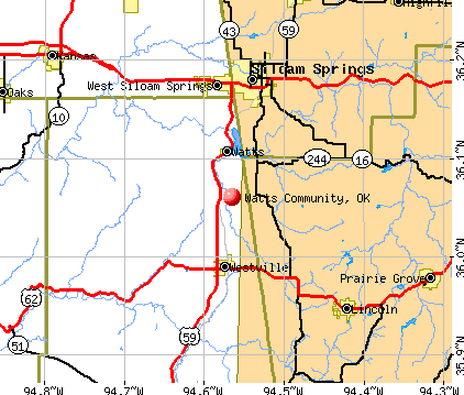
- OSM Map
- General Map
- Google Map
- MSN Map
| Males: 274 | |
| Females: 247 |
| Median resident age: | 37.6 years |
| Oklahoma median age: | 35.5 years |
Zip codes: 74964.
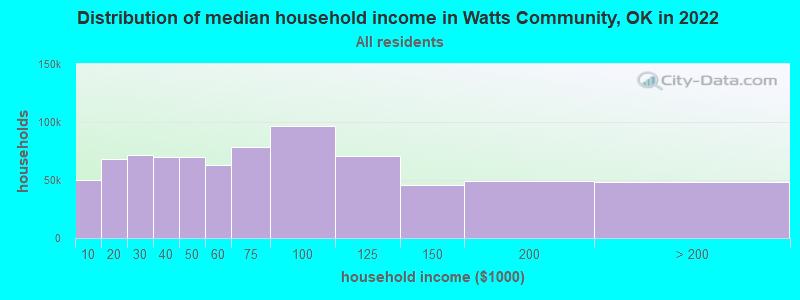
| Watts Community: | $58,201 |
| OK: | $59,673 |
Estimated per capita income in 2022: $22,248 (it was $12,271 in 2000)
Watts Community CDP income, earnings, and wages data
Estimated median house or condo value in 2022: $193,504 (it was $74,600 in 2000)
| Watts Community: | $193,504 |
| OK: | $191,700 |
Watts Community, OK residents, houses, and apartments details
Detailed information about poverty and poor residents in Watts Community, OK


- 33967.8%White alone
- 8416.8%American Indian alone
- 7014.0%Two or more races
- 61.2%Hispanic
- 10.2%Other race alone
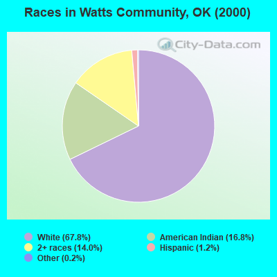
Races in Watts Community detailed stats: ancestries, foreign born residents, place of birth
 Recent articles from our blog. Our writers, many of them Ph.D. graduates or candidates, create easy-to-read articles on a wide variety of topics.

Ancestries: Irish (15.2%), United States (13.8%), English (9.6%), West Indian (5.0%), German (4.2%), Dutch (2.4%).
Current Local Time: CST time zone
Land area: 17.8 square miles.
Population density: 29 people per square mile (very low).
| Watts Community CDP: | 0.5% ($361) |
| Oklahoma: | 0.8% ($523) |
Nearest city with pop. 50,000+: Fayetteville, AR  (22.6 miles , pop. 58,047).
Nearest city with pop. 200,000+: Tulsa, OK (76.8 miles , pop. 393,049).
Nearest city with pop. 1,000,000+: Dallas, TX (258.7 miles , pop. 1,188,580).
Nearest cities:
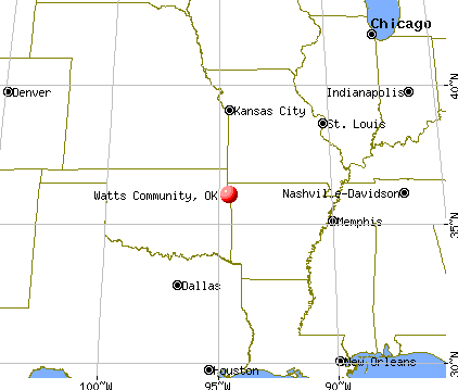
), ), Latitude: 36.06 N, Longitude: 94.57 W
Area code commonly used in this area: 918
| Here: | 3.7% |
| Oklahoma: | 3.2% |
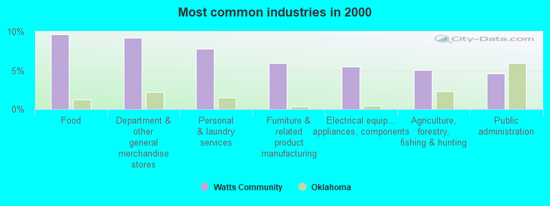
- Food (9.6%)
- Department & other general merchandise stores (9.2%)
- Personal & laundry services (7.8%)
- Furniture & related product manufacturing (6.0%)
- Electrical equipment, appliances, components (5.5%)
- Agriculture, forestry, fishing & hunting (5.0%)
- Public administration (4.6%)
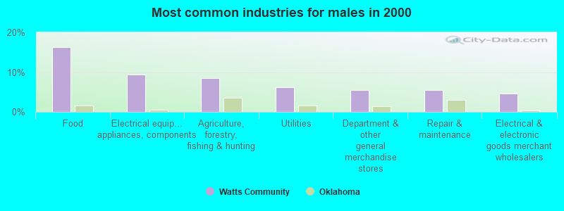
- Food (16.3%)
- Electrical equipment, appliances, components (9.3%)
- Agriculture, forestry, fishing & hunting (8.5%)
- Utilities (6.2%)
- Department & other general merchandise stores (5.4%)
- Repair & maintenance (5.4%)
- Electrical & electronic goods merchant wholesalers (4.7%)
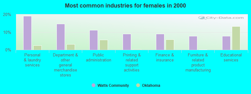
- Personal & laundry services (19.1%)
- Department & other general merchandise stores (14.6%)
- Public administration (11.2%)
- Printing & related support activities (9.0%)
- Finance & insurance (9.0%)
- Furniture & related product manufacturing (7.9%)
- Educational services (7.9%)
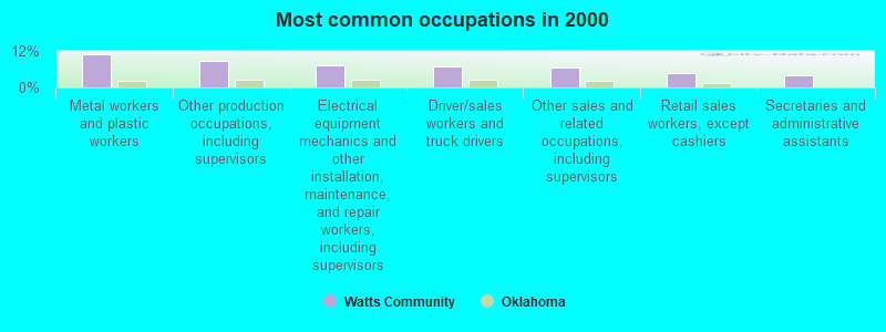
- Metal workers and plastic workers (11.0%)
- Other production occupations, including supervisors (8.7%)
- Electrical equipment mechanics and other installation, maintenance, and repair workers, including supervisors (7.3%)
- Driver/sales workers and truck drivers (6.9%)
- Other sales and related occupations, including supervisors (6.4%)
- Retail sales workers, except cashiers (4.6%)
- Secretaries and administrative assistants (4.1%)
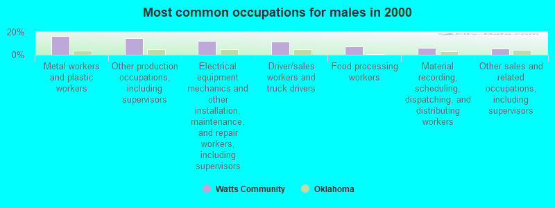
- Metal workers and plastic workers (16.3%)
- Other production occupations, including supervisors (14.7%)
- Electrical equipment mechanics and other installation, maintenance, and repair workers, including supervisors (12.4%)
- Driver/sales workers and truck drivers (11.6%)
- Food processing workers (7.0%)
- Material recording, scheduling, dispatching, and distributing workers (6.2%)
- Other sales and related occupations, including supervisors (5.4%)

- Secretaries and administrative assistants (10.1%)
- Textile, apparel, and furnishings workers (10.1%)
- Personal appearance workers (9.0%)
- Financial clerks, except bookkeeping, accounting and auditing clerks (9.0%)
- Other office and administrative support workers, including supervisors (9.0%)
- Retail sales workers, except cashiers (7.9%)
- Other sales and related occupations, including supervisors (7.9%)
Average climate in Watts Community, Oklahoma
Based on data reported by over 4,000 weather stations


(lower is better)
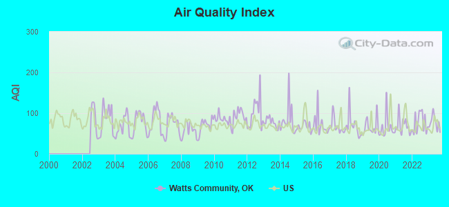
Air Quality Index (AQI) level in 2023 was 76.7. This is about average.
| City: | 76.7 |
| U.S.: | 72.6 |
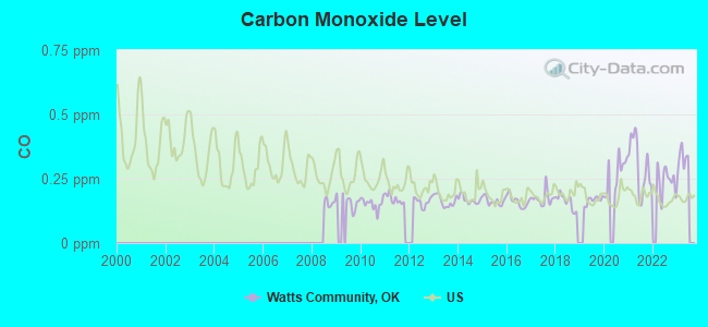
Carbon Monoxide (CO) [ppm] level in 2022 was 0.243. This is about average. Closest monitor was 22.2 miles away from the city center.
| City: | 0.243 |
| U.S.: | 0.251 |
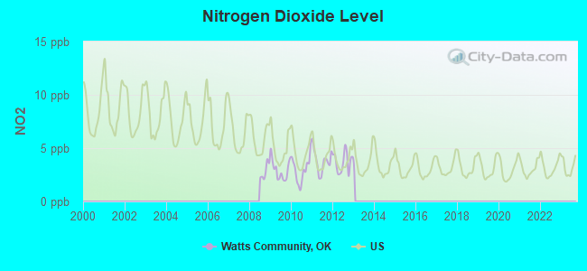
Nitrogen Dioxide (NO2) [ppb] level in 2012 was 3.69. This is better than average. Closest monitor was 22.2 miles away from the city center.
| City: | 3.69 |
| U.S.: | 5.11 |
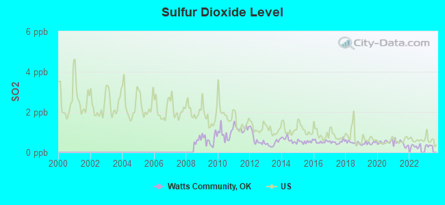
Sulfur Dioxide (SO2) [ppb] level in 2022 was 0.305. This is significantly better than average. Closest monitor was 18.2 miles away from the city center.
| City: | 0.305 |
| U.S.: | 1.515 |
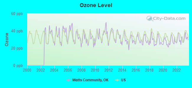
Ozone [ppb] level in 2023 was 31.9. This is about average. Closest monitor was 22.2 miles away from the city center.
| City: | 31.9 |
| U.S.: | 33.3 |
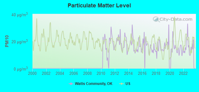
Particulate Matter (PM10) [µg/m3] level in 2022 was 16.4. This is about average. Closest monitor was 22.2 miles away from the city center.
| City: | 16.4 |
| U.S.: | 19.2 |
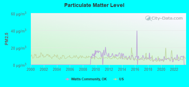
Particulate Matter (PM2.5) [µg/m3] level in 2022 was 6.76. This is about average. Closest monitor was 22.2 miles away from the city center.
| City: | 6.76 |
| U.S.: | 8.11 |
Tornado activity:
Watts Community-area historical tornado activity is slightly below Oklahoma state average. It is 115% greater than the overall U.S. average.
On 11/22/1983, a category F3 (max. wind speeds 158-206 mph) tornado 2.6 miles away from the Watts Community place center caused between $50,000 and $500,000 in damages.
On 11/22/1983, a category F3 tornado 3.1 miles away from the place center injured 6 people and caused between $500,000 and $5,000,000 in damages.
Earthquake activity:
Watts Community-area historical earthquake activity is significantly above Oklahoma state average. It is 671% greater than the overall U.S. average.On 9/3/2016 at 12:02:44, a magnitude 5.8 (5.8 MW, Depth: 3.5 mi, Class: Moderate, Intensity: VI - VII) earthquake occurred 134.3 miles away from Watts Community center
On 11/6/2011 at 03:53:10, a magnitude 5.7 (5.7 MW, Depth: 3.2 mi) earthquake occurred 128.7 miles away from the city center
On 11/7/2016 at 01:44:24, a magnitude 5.0 (5.0 MW, Depth: 2.8 mi) earthquake occurred 125.3 miles away from Watts Community center
On 11/5/2011 at 07:12:45, a magnitude 4.8 (4.8 MW, Depth: 1.9 mi, Class: Light, Intensity: IV - V) earthquake occurred 128.3 miles away from Watts Community center
On 11/8/2011 at 02:46:57, a magnitude 4.8 (4.8 MW, Depth: 3.1 mi) earthquake occurred 130.0 miles away from Watts Community center
On 2/28/2011 at 05:00:50, a magnitude 4.7 (4.7 MW, Depth: 2.0 mi) earthquake occurred 135.8 miles away from Watts Community center
Magnitude types: moment magnitude (MW)
Natural disasters:
The number of natural disasters in Adair County (22) is greater than the US average (15).Major Disasters (Presidential) Declared: 14
Emergencies Declared: 6
Causes of natural disasters: Floods: 13, Storms: 11, Winter Storms: 8, Tornadoes: 7, Heavy Rain: 1, Hurricane: 1, Snow: 1, Wind: 1, Other: 1 (Note: some incidents may be assigned to more than one category).
Hospitals and medical centers near Watts Community:
- WESTVILLE NURSING HOME ICF (Nursing Home, about 5 miles away; WESTVILLE, OK)
- DIALYSIS CENTER OF SILOAM SPRINGS (Dialysis Facility, about 9 miles away; SILOAM SPRINGS, AR)
- SILOAM SPRINGS NURSING AND REHABILITATION CENTER (Nursing Home, about 10 miles away; SILOAM SPRINGS, AR)
- PRAIRIE GROVE HEALTH AND REHABILITATION, LLC (Nursing Home, about 16 miles away; PRAIRIE GROVE, AR)
Colleges/universities with over 2000 students nearest to Watts Community:
- John Brown University (about 10 miles; Siloam Springs, AR; Full-time enrollment: 2,097)
- University of Arkansas (about 22 miles; Fayetteville, AR; FT enrollment: 22,163)
- Northeastern State University (about 25 miles; Tahlequah, OK; FT enrollment: 6,895)
- NorthWest Arkansas Community College (about 31 miles; Bentonville, AR; FT enrollment: 5,634)
- University of Arkansas-Fort Smith (about 48 miles; Fort Smith, AR; FT enrollment: 6,103)
- Crowder College (about 54 miles; Neosho, MO; FT enrollment: 3,675)
- Northeastern Oklahoma A&M College (about 59 miles; Miami, OK; FT enrollment: 2,075)
Points of interest:
Cemeteries: Westville Cemetery (1), Reverend Jesse Bushyhead Grave (2), Baptist Mission Cemeter (3), Phillips Cemetery (4). Display/hide their locations on the map
Reservoir: Lake Frances (A). Display/hide its location on the map
| This place: | 2.6 people |
| Oklahoma: | 2.5 people |
| This place: | 75.0% |
| Whole state: | 69.1% |
| This place: | 5.7% |
| Whole state: | 4.0% |
No gay or lesbian households reported
| This place: | 15.4% |
| Whole state: | 14.7% |
| This place: | 3.9% |
| Whole state: | 6.1% |
For population 15 years and over in Watts Community:
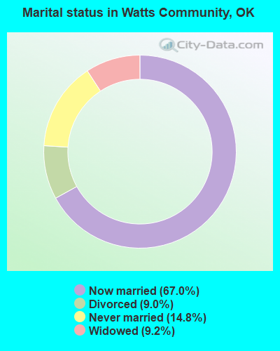
- Never married: 14.8%
- Now married: 67.0%
- Separated: 0.0%
- Widowed: 9.2%
- Divorced: 9.0%
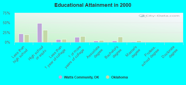
For population 25 years and over in Watts Community:
- High school or higher: 77.9%
- Bachelor's degree or higher: 5.3%
- Graduate or professional degree: 1.6%
- Unemployed: 1.4%
- Mean travel time to work (commute): 25.1 minutes
| Here: | 8.0 |
| Oklahoma average: | 11.7 |
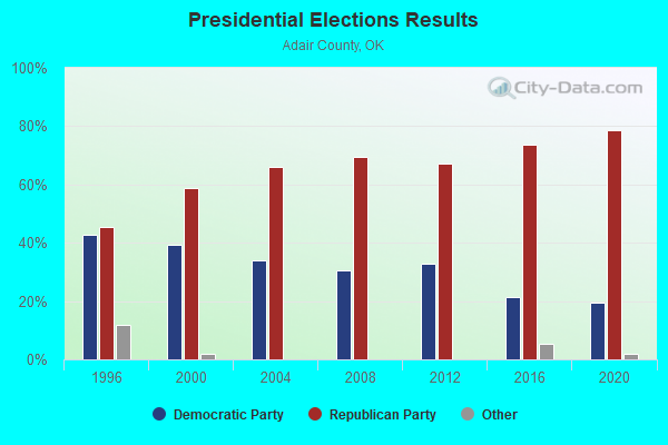
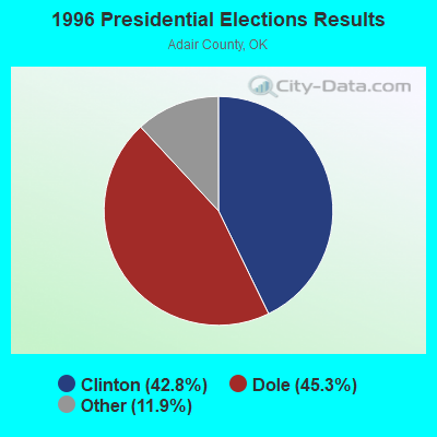
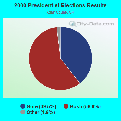
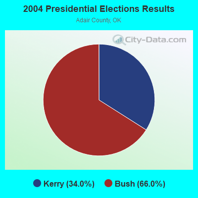
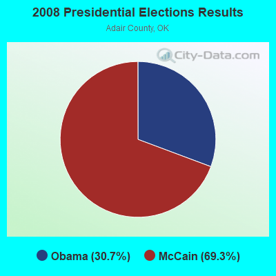
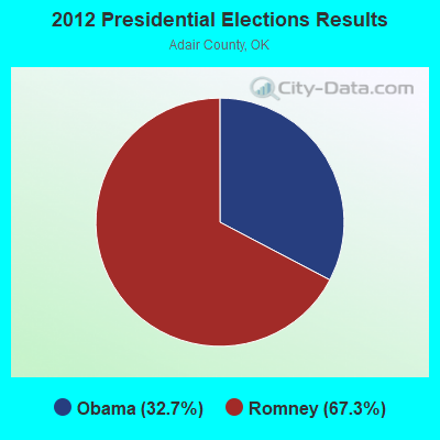
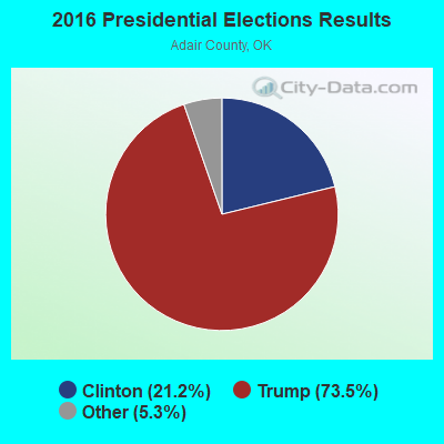
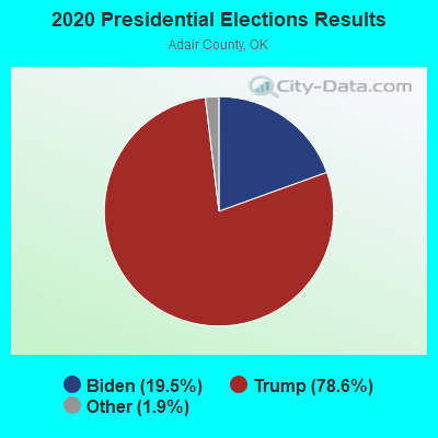
Graphs represent county-level data. Detailed 2008 Election Results
Religion statistics for Watts Community, OK (based on Adair County data)
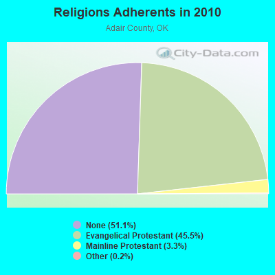
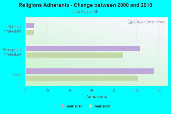
| Religion | Adherents | Congregations |
|---|---|---|
| Evangelical Protestant | 10,325 | 53 |
| Mainline Protestant | 741 | 3 |
| Other | 36 | - |
| None | 11,581 | - |
Food Environment Statistics:
| Adair County: | 2.29 / 10,000 pop. |
| Oklahoma: | 1.97 / 10,000 pop. |
| This county: | 0.46 / 10,000 pop. |
| Oklahoma: | 0.76 / 10,000 pop. |
| This county: | 5.95 / 10,000 pop. |
| Oklahoma: | 4.35 / 10,000 pop. |
| This county: | 2.29 / 10,000 pop. |
| Oklahoma: | 6.89 / 10,000 pop. |
| Adair County: | 12.5% |
| State: | 10.3% |
| Adair County: | 32.7% |
| Oklahoma: | 29.2% |
Strongest AM radio stations in Watts Community:
- KUOA (1290 AM; 5 kW; SILOAM SPRINGS, AR; Owner: KUOA, INC.)
- KFAY (1030 AM; 10 kW; FARMINGTON, AR; Owner: CUMULUS LICENSING CORP)
- KFAQ (1170 AM; 50 kW; TULSA, OK; Owner: JOURNAL BROADCAST CORPORATION)
- KRMG (740 AM; 50 kW; TULSA, OK; Owner: CXR HOLDINGS, INC.)
- KURM (790 AM; 5 kW; ROGERS, AR; Owner: KERM, INC)
- KYHN (1320 AM; 10 kW; FORT SMITH, AR; Owner: CAPSTAR TX LIMITED PARTNERSHIP)
- KTBZ (1430 AM; 25 kW; TULSA, OK; Owner: CLEAR CHANNEL BROADCASTING LICENSES, INC.)
- KWHN (1650 AM; 10 kW; FT. SMITH, AR; Owner: CAPSTAR TX LIMITED PARTNERSHIP)
- KOFC (1250 AM; 1 kW; FAYETTEVILLE, AR; Owner: WILLIAM B. DISNEY & MARTHA J. DISNEY)
- KMUS (1380 AM; 20 kW; MUSKOGEE, OK; Owner: ABC, INC.)
- KBTN (1420 AM; 10 kW; NEOSHO, MO; Owner: PETRACOM OF JOPLIN, L.L.C.)
- KREB (1190 AM; daytime; 2 kW; BENTONVILLE/BELLA VI, AR; Owner: BUTLER BROADCASTING COMPANY, LLC)
- KZRA (1590 AM; 2 kW; SPRINGDALE, AR; Owner: CUMULUS LICENSING CORP.)
Strongest FM radio stations in Watts Community:
- KLRC (101.1 FM; SILOAM SPRINGS, AR; Owner: JOHN BROWN UNIVERSITY)
- KDAB (94.9 FM; PRAIRIE GROVE, AR; Owner: CUMULUS LICENSING CORP.)
- KBVA (106.5 FM; BELLA VISTA, AR; Owner: GAYLA JOY HENDREN)
- KAYH (89.3 FM; FAYETTEVILLE, AR; Owner: FAMILY VISION MINISTRIES, INC.)
- KEZA (107.9 FM; FAYETTEVILLE, AR; Owner: CAPSTAR TX LIMITED PARTNERSHIP)
- KMCK-FM (105.7 FM; SILOAM SPRINGS, AR; Owner: CUMULUS LICENSING CORP.)
- KUAF (91.3 FM; FAYETTEVILLE, AR; Owner: BOARD OF TRUSTEES OF THE UNIVERSITY OF ARKANSAS)
- KISR (93.7 FM; FORT SMITH, AR; Owner: STEREO 93, INC.)
- KKIX (103.9 FM; FAYETTEVILLE, AR; Owner: CAPSTAR TX LIMITED PARTNERSHIP)
- KREU (92.3 FM; ROLAND, OK; Owner: STAR 92 CO.)
- K204CA (88.7 FM; TAHLEQUAH, OK; Owner: THE MOODY BIBLE INSTITUTE OF CHICAGO)
- KURM-FM (100.3 FM; SOUTHWEST CITY, MO; Owner: KERM, INC.)
- K244DS (96.7 FM; FAYETTEVILLE, AR; Owner: BUTLER BROADCASTING COMPANY, LLC)
- KFAY-FM (98.3 FM; BENTONVILLE, AR; Owner: CUMULUS LICENSING CORP)
- KXNA (104.9 FM; SPRINGDALE, AR; Owner: BUTLER BROADCASTING COMPANY, LLC)
- K203CE (88.5 FM; SPRINGDALE, AR; Owner: BIBLE BROADCASTING NETWORK, INC.)
- KKEG (92.1 FM; FAYETTEVILLE, AR; Owner: CUMULUS LICENSING CORP)
- KXUA (88.3 FM; FAYETTEVILLE, AR; Owner: BRD. OF TRUST. OF UNIV. OF ARKANSAS)
TV broadcast stations around Watts Community:
- K33FG (Channel 33; SILOAM SPRINGS, AR; Owner: FORT SMITH 46, INC.)
- KFSM-TV (Channel 5; FORT SMITH, AR; Owner: NEW YORK TIMES MANAGEMENT SERVICES)
- KAFT (Channel 13; FAYETTEVILLE, AR; Owner: ARKANSAS EDUCATIONAL TELEVISION COMMISSION)
- KTUL (Channel 8; TULSA, OK; Owner: KTUL, LLC)
- KSBN-TV (Channel 57; SPRINGDALE, AR; Owner: TOTAL LIFE COMMUNITY EDUCATIONAL FOUNDATION)
- KHOG-TV (Channel 29; FAYETTEVILLE, AR; Owner: KHBS HEARST-ARGYLE TELEVISION, INC.)
- K62DQ (Channel 62; FAYETTEVILLE, ETC., AR; Owner: NEW YORK TIMES MANAGEMENT SERVICES)
- K64FO (Channel 64; FAYETTEVILLE, AR; Owner: FORT SMITH 46, INC.)
- KFAA (Channel 51; ROGERS, AR; Owner: J.D.G. TELEVISION, INC.)
- K15DR (Channel 15; SPRINGDALE, AR; Owner: FORT SMITH 46, INC.)
- K59ES (Channel 59; HINDSVILLE, AR; Owner: FORT SMITH 46, INC.)
- K68ET (Channel 68; FORT SMITH, AR; Owner: FORT SMITH 46, INC.)
- K52GX (Channel 52; TAHLEQUAH, OK; Owner: TRINITY BROADCASTING NETWORK)
Watts Community fatal accident list:
Nov 7, 2014 01:06 PM, Us-59, Lat: 36.006547, Lon: -94.583742, Vehicles: 2, Persons: 2, Fatalities: 1
Sep 16, 2011 03:53 PM, Us-59, Lat: 36.017906, Lon: -94.583783, Vehicles: 2, Persons: 5, Fatalities: 1
Jun 11, 2009 02:21 PM, Us-59, Lat: 36.033831, Lon: -94.583358, Vehicles: 1, Persons: 1, Fatalities: 1
- National Bridge Inventory (NBI) Statistics
- 4Number of bridges
- 36ft / 10.8mTotal length
- $2,197,000Total costs
- 583Total average daily traffic
- 83Total average daily truck traffic
- 933Total future (year 2040) average daily traffic
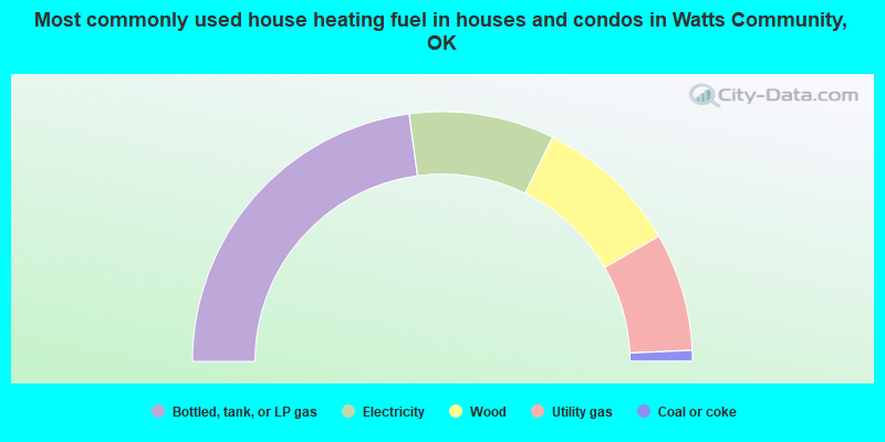
- 45.8%Bottled, tank, or LP gas
- 18.8%Electricity
- 18.8%Wood
- 15.3%Utility gas
- 1.4%Coal or coke
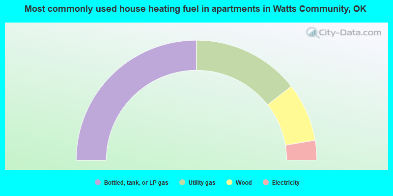
- 50.0%Bottled, tank, or LP gas
- 28.9%Utility gas
- 15.8%Wood
- 5.3%Electricity
Watts Community compared to Oklahoma state average:
- Unemployed percentage significantly below state average.
- Black race population percentage significantly below state average.
- Hispanic race population percentage significantly below state average.
- Foreign-born population percentage significantly below state average.
- Renting percentage significantly below state average.
- Length of stay since moving in significantly above state average.
- Number of rooms per house significantly below state average.
- House age significantly below state average.
- Number of college students below state average.
- Percentage of population with a bachelor's degree or higher significantly below state average.