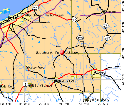
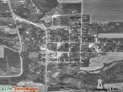
Wattsburg, Pennsylvania
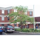
Wattsburg: Wattsburg, PA
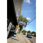
Wattsburg: Wattsburg, PA
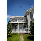
Wattsburg: Wattsburg, PA
Wattsburg: Wattsburg, PA
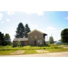
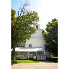
Wattsburg: Wattsburg School
Wattsburg: Wattsburg, PA
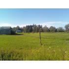
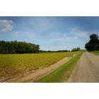
Wattsburg: Horse grazing in Wattsburg
- add
your
Submit your own pictures of this borough and show them to the world
- OSM Map
- General Map
- Google Map
- MSN Map
Population change since 2000: -8.5%
 |
| Males: 161 | |
| Females: 185 |
| Median resident age: | 34.2 years |
| Pennsylvania median age: | 40.9 years |
Zip codes: 16442.
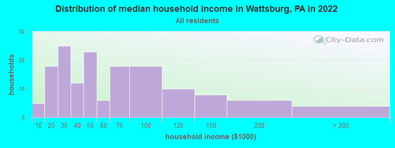
| Wattsburg: | $46,926 |
| PA: | $71,798 |
Estimated per capita income in 2022: $21,433 (it was $14,830 in 2000)
Wattsburg borough income, earnings, and wages data
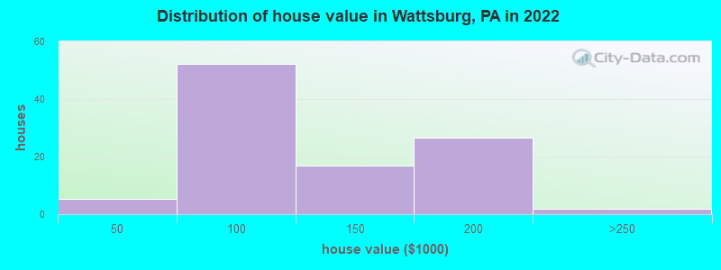
Estimated median house or condo value in 2022: $99,753 (it was $67,200 in 2000)
| Wattsburg: | $99,753 |
| PA: | $245,500 |
Mean prices in 2022: all housing units: $124,882; detached houses: $129,972; mobile homes: $92,077
Median gross rent in 2022: $1,060.
Detailed information about poverty and poor residents in Wattsburg, PA
Compare current foreclosures near Wattsburg, PA:
| Photo | Address | Area | Beds / Baths | Price | Details |
|---|---|---|---|---|---|

|
#1
Macedonia Rd
Wattsburg, PA 16442
|
1,264 sq. feet
|
1 baths 3 beds |
show details | |

|
#2
Creek Rd
Wattsburg, PA 16442
|
2,072 sq. feet
|
1 baths 3 beds |
show details | |

|
#3
Page Rd
Wattsburg, PA 16442
|
924 sq. feet
|
- baths - beds |
show details | |

|
#4
Sunshine Ln Lot 27
Wattsburg, PA 16442
|
938 sq. feet
|
- baths - beds |
show details | |

|
#5
Knoyle Rd
Wattsburg, PA 16442
|
- sq. feet
|
- baths - beds |
show details | |

|
#6
Hill Rd
Wattsburg, PA 16442
|
- sq. feet
|
- baths - beds |
show details | |

|
#7
Mead Ave
Corry, PA 16407
|
1,272 sq. feet
|
2 baths 3 beds |
$19,900
|
show details |

|
#8
E 33rd St
Erie, PA 16504
|
912 sq. feet
|
1 baths 2 beds |
$34,900
|
show details |

|
#9
W 37th St
Erie, PA 16508
|
2,304 sq. feet
|
2 baths 3 beds |
show details | |

|
#10
E 19th St
Erie, PA 16503
|
- sq. feet
|
1 baths 2 beds |
show details |
| Photo | Address | Area | Beds / Baths | Price | Details |
|---|---|---|---|---|---|

|
#11
Old French Rd
Erie, PA 16509
|
1,788 sq. feet
|
3 baths 5 beds |
show details | |

|
#12
E 40th St
Erie, PA 16510
|
1,176 sq. feet
|
1 baths 3 beds |
show details | |

|
#13
Polk St
Erie, PA 16503
|
504 sq. feet
|
1 baths 2 beds |
show details | |

|
#14
Conway St
Erie, PA 16509
|
1,768 sq. feet
|
2 baths 3 beds |
show details | |

|
#15
W 32nd St
Erie, PA 16508
|
1,280 sq. feet
|
2 baths 3 beds |
show details | |

|
#16
Warden St
Union City, PA 16438
|
1,228 sq. feet
|
1 baths 3 beds |
show details | |

|
#17
Lake Cliff Dr
Erie, PA 16511
|
1,836 sq. feet
|
2 baths 3 beds |
show details | |

|
#18
Post Ave
Erie, PA 16508
|
1,232 sq. feet
|
1 baths 2 beds |
show details | |

|
#19
Oak Tree Ct
Erie, PA 16511
|
2,066 sq. feet
|
2 baths 3 beds |
show details | |

|
#20
E 28th St
Erie, PA 16504
|
1,128 sq. feet
|
1 baths 2 beds |
show details |
| Photo | Address | Area | Beds / Baths | Price | Details |
|---|---|---|---|---|---|

|
#21
W Gore Rd
Erie, PA 16509
|
2,366 sq. feet
|
2 baths 3 beds |
show details | |

|
#22
E 25th St
Erie, PA 16503
|
1,680 sq. feet
|
2 baths 3 beds |
show details | |

|
#23
German St
Erie, PA 16504
|
2,024 sq. feet
|
2 baths 4 beds |
show details | |

|
#24
Pagan Rd
Erie, PA 16509
|
1,440 sq. feet
|
1 baths 3 beds |
show details | |

|
#25
E Lake Rd
Erie, PA 16511
|
1,574 sq. feet
|
1 baths 2 beds |
show details | |

|
#26
Dorchester Dr
Erie, PA 16509
|
1,848 sq. feet
|
1 baths 3 beds |
show details | |

|
#27
Bolivar St
Erie, PA 16508
|
1,488 sq. feet
|
1 baths 3 beds |
show details | |

|
#28
Aaron Rd
Erie, PA 16511
|
2,504 sq. feet
|
2 baths 4 beds |
show details | |

|
#29
E 32nd St
Erie, PA 16504
|
1,181 sq. feet
|
1 baths 2 beds |
show details | |

|
#30
E 25th St
Erie, PA 16503
|
2,412 sq. feet
|
2 baths 5 beds |
show details |
| Photo | Address | Area | Beds / Baths | Price | Details |
|---|---|---|---|---|---|

|
#31
Longacre Ave
Erie, PA 16509
|
2,152 sq. feet
|
2 baths 3 beds |
show details | |

|
#32
E 23rd St
Erie, PA 16503
|
1,344 sq. feet
|
1 baths 3 beds |
show details | |

|
#33
E 30th St
Erie, PA 16504
|
1,560 sq. feet
|
2 baths 4 beds |
show details | |

|
#34
Glenwood Park Ave
Erie, PA 16508
|
1,162 sq. feet
|
1 baths 3 beds |
show details | |

|
#35
Shunpike Rd
Erie, PA 16508
|
1,278 sq. feet
|
1 baths 2 beds |
show details | |

|
#36
Harding Dr
Erie, PA 16509
|
1,103 sq. feet
|
1 baths 3 beds |
show details | |

|
#37
Miller Ave
Erie, PA 16509
|
1,440 sq. feet
|
1 baths 3 beds |
show details | |

|
#38
Cochran St
Erie, PA 16508
|
1,328 sq. feet
|
1 baths 3 beds |
show details | |

|
#39
E 24th St
Erie, PA 16503
|
1,635 sq. feet
|
1 baths 3 beds |
show details | |

|
#40
Eliot Rd
Erie, PA 16508
|
1,508 sq. feet
|
1 baths 3 beds |
show details |
| Photo | Address | Area | Beds / Baths | Price | Details |
|---|---|---|---|---|---|

|
#41
Hazel St
Erie, PA 16508
|
1,101 sq. feet
|
1 baths 3 beds |
show details | |

|
#42
E Main St
North East, PA 16428
|
1,184 sq. feet
|
1 baths 3 beds |
show details | |

|
#43
Robinson St
North East, PA 16428
|
2,778 sq. feet
|
2 baths 4 beds |
show details | |

|
#44
E 28th St
Erie, PA 16504
|
1,056 sq. feet
|
1 baths 4 beds |
show details | |

|
#45
Washington Ave
Erie, PA 16509
|
2,124 sq. feet
|
2 baths 4 beds |
show details | |

|
#46
Iroquois Ave
Erie, PA 16511
|
1,140 sq. feet
|
1 baths 4 beds |
show details | |

|
#47
Buffalo Rd
Erie, PA 16510
|
1,232 sq. feet
|
1 baths 3 beds |
show details | |

|
#48
Edinboro Rd
Mc Kean, PA 16426
|
1,165 sq. feet
|
1 baths 3 beds |
show details | |

|
#49
E 27th St
Erie, PA 16504
|
1,152 sq. feet
|
1 baths 3 beds |
show details | |

|
Check over 1 million property listings on Foreclosure.com!
|
browse all offers | |||


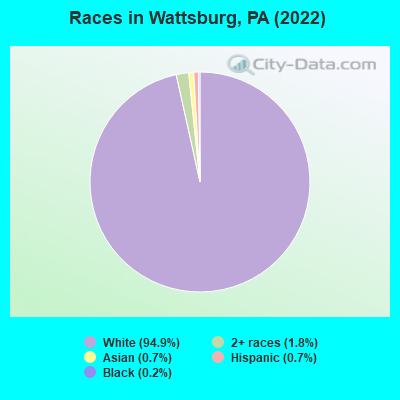
- 43094.9%White alone
- 81.8%Two or more races
- 30.7%Asian alone
- 30.7%Hispanic
- 10.2%Black alone
Races in Wattsburg detailed stats: ancestries, foreign born residents, place of birth
According to our research of Pennsylvania and other state lists, there were 8 registered sex offenders living in Wattsburg, Pennsylvania as of May 10, 2024.
The ratio of all residents to sex offenders in Wattsburg is 64 to 1.
 Recent articles from our blog. Our writers, many of them Ph.D. graduates or candidates, create easy-to-read articles on a wide variety of topics.

 | going through some areas (17 replies) |
| Property tax question..... (19 replies) |
| Moving to Meadville - Erie (3 replies) |
| Wanting to move from Staten Island NY to PA (14 replies) |
| What are good places to live in Erie PA? (20 replies) |
| Can I afford to live anywhere in Pennsylvania? (32 replies) |
Latest news from Wattsburg, PA collected exclusively by city-data.com from local newspapers, TV, and radio stations
Ancestries: German (60.1%), Italian (6.9%), American (6.4%), English (4.6%), Polish (4.6%), Irish (1.2%).
Current Local Time: EST time zone
Incorporated in 1833
Elevation: 1290 feet
Land area: 0.33 square miles.
Population density: 1,063 people per square mile (low).
7 residents are foreign born
| This borough: | 1.5% |
| Pennsylvania: | 7.3% |
Median real estate property taxes paid for housing units with mortgages in 2022: $1,904 (1.5%)
Median real estate property taxes paid for housing units with no mortgage in 2022: $1,664 (1.8%)
Nearest city with pop. 50,000+: Erie, PA  (15.7 miles , pop. 103,717).
Nearest city with pop. 200,000+: Buffalo, NY (79.3 miles , pop. 292,648).
Nearest city with pop. 1,000,000+: Philadelphia, PA (280.2 miles , pop. 1,517,550).
Nearest cities:
), )Latitude: 42.00 N, Longitude: 79.81 W
Area code: 814
| Here: | 3.3% |
| Pennsylvania: | 2.9% |
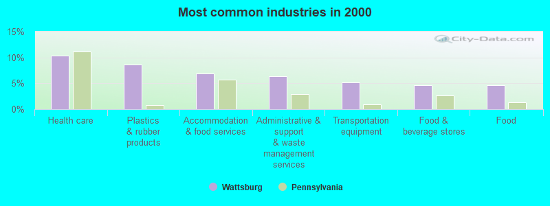
- Health care (10.3%)
- Plastics & rubber products (8.6%)
- Accommodation & food services (6.9%)
- Administrative & support & waste management services (6.3%)
- Transportation equipment (5.2%)
- Food & beverage stores (4.6%)
- Food (4.6%)
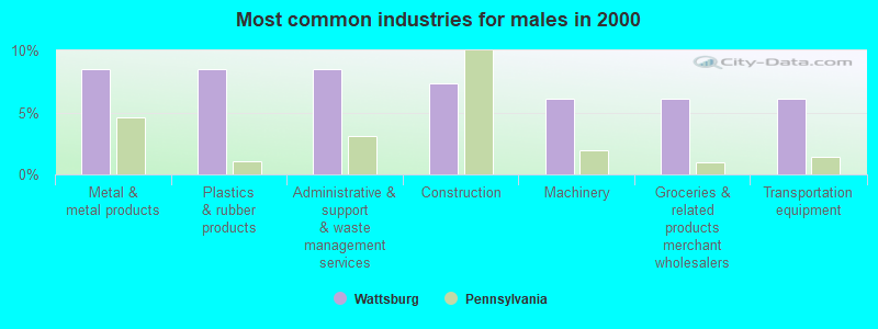
- Metal & metal products (8.5%)
- Plastics & rubber products (8.5%)
- Administrative & support & waste management services (8.5%)
- Construction (7.3%)
- Machinery (6.1%)
- Groceries & related products merchant wholesalers (6.1%)
- Transportation equipment (6.1%)
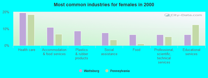
- Health care (19.6%)
- Accommodation & food services (10.9%)
- Plastics & rubber products (8.7%)
- Social assistance (7.6%)
- Food (6.5%)
- Professional, scientific, technical services (6.5%)
- Educational services (6.5%)
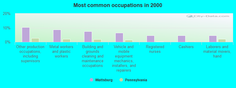
- Other production occupations, including supervisors (10.3%)
- Metal workers and plastic workers (8.6%)
- Building and grounds cleaning and maintenance occupations (7.5%)
- Vehicle and mobile equipment mechanics, installers, and repairers (6.3%)
- Registered nurses (4.6%)
- Cashiers (4.6%)
- Laborers and material movers, hand (4.6%)
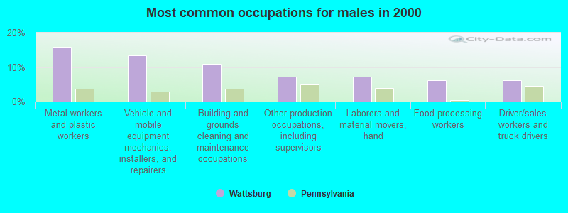
- Metal workers and plastic workers (15.9%)
- Vehicle and mobile equipment mechanics, installers, and repairers (13.4%)
- Building and grounds cleaning and maintenance occupations (11.0%)
- Other production occupations, including supervisors (7.3%)
- Laborers and material movers, hand (7.3%)
- Food processing workers (6.1%)
- Driver/sales workers and truck drivers (6.1%)
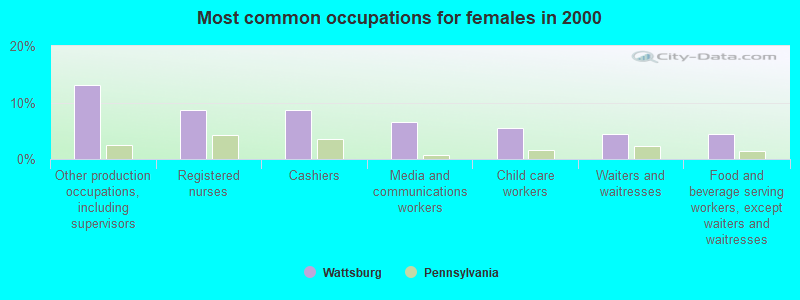
- Other production occupations, including supervisors (13.0%)
- Registered nurses (8.7%)
- Cashiers (8.7%)
- Media and communications workers (6.5%)
- Child care workers (5.4%)
- Waiters and waitresses (4.3%)
- Food and beverage serving workers, except waiters and waitresses (4.3%)
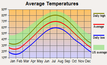
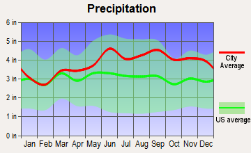
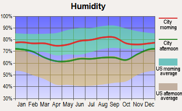
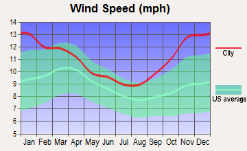
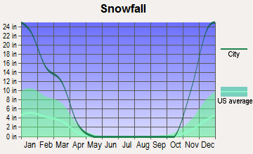
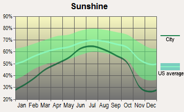
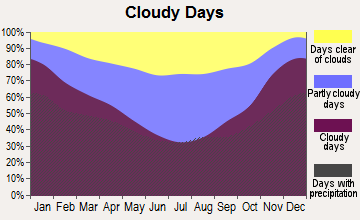
Average climate in Wattsburg, Pennsylvania
Based on data reported by over 4,000 weather stations
(lower is better)
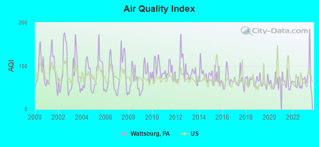
Air Quality Index (AQI) level in 2023 was 81.2. This is about average.
| City: | 81.2 |
| U.S.: | 72.6 |
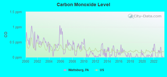
Carbon Monoxide (CO) [ppm] level in 2023 was 0.120. This is significantly better than average. Closest monitor was 15.2 miles away from the city center.
| City: | 0.120 |
| U.S.: | 0.251 |
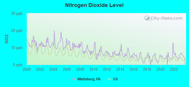
Nitrogen Dioxide (NO2) [ppb] level in 2023 was 5.31. This is about average. Closest monitor was 12.4 miles away from the city center.
| City: | 5.31 |
| U.S.: | 5.11 |
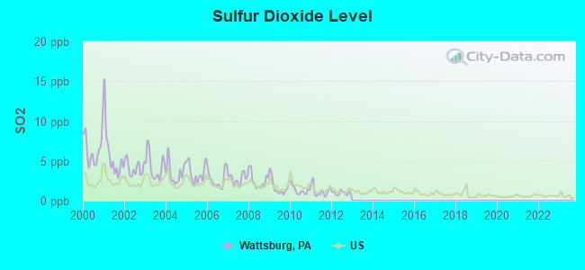
Sulfur Dioxide (SO2) [ppb] level in 2012 was 0.972. This is significantly better than average. Closest monitor was 17.3 miles away from the city center.
| City: | 0.972 |
| U.S.: | 1.515 |
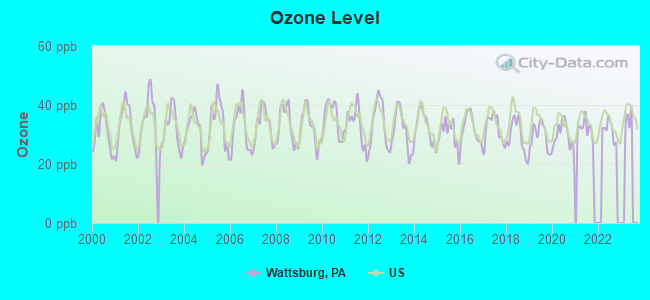
Ozone [ppb] level in 2022 was 31.5. This is about average. Closest monitor was 12.4 miles away from the city center.
| City: | 31.5 |
| U.S.: | 33.3 |
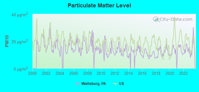
Particulate Matter (PM10) [µg/m3] level in 2023 was 15.9. This is better than average. Closest monitor was 15.2 miles away from the city center.
| City: | 15.9 |
| U.S.: | 19.2 |
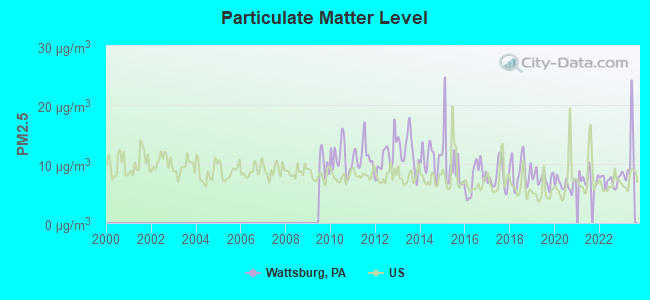
Particulate Matter (PM2.5) [µg/m3] level in 2023 was 11.1. This is worse than average. Closest monitor was 15.2 miles away from the city center.
| City: | 11.1 |
| U.S.: | 8.1 |
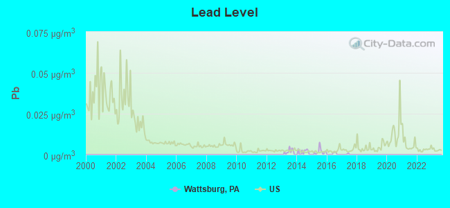
Lead (Pb) [µg/m3] level in 2016 was 0.00043. This is significantly better than average. Closest monitor was 15.3 miles away from the city center.
| City: | 0.00043 |
| U.S.: | 0.00931 |
Tornado activity:
Wattsburg-area historical tornado activity is slightly below Pennsylvania state average. It is 32% smaller than the overall U.S. average.
On 5/31/1985, a category F4 (max. wind speeds 207-260 mph) tornado 8.8 miles away from the Wattsburg borough center .
On 5/31/1985, a category F4 tornado 24.9 miles away from the borough center killed 12 people and injured 82 people and caused between $5,000,000 and $50,000,000 in damages.
Earthquake activity:
Wattsburg-area historical earthquake activity is significantly above Pennsylvania state average. It is 63% smaller than the overall U.S. average.On 9/25/1998 at 19:52:52, a magnitude 5.2 (4.8 MB, 4.3 MS, 5.2 LG, 4.5 MW, Depth: 3.1 mi, Class: Moderate, Intensity: VI - VII) earthquake occurred 46.6 miles away from the city center
On 1/31/1986 at 16:46:43, a magnitude 5.0 (5.0 MB) earthquake occurred 75.0 miles away from the city center
On 8/23/2011 at 17:51:04, a magnitude 5.8 (5.8 MW, Depth: 3.7 mi) earthquake occurred 300.0 miles away from the city center
On 10/7/1983 at 10:18:46, a magnitude 5.3 (5.1 MB, 5.3 LG, 5.1 ML) earthquake occurred 307.7 miles away from Wattsburg center
On 1/26/2001 at 03:03:20, a magnitude 3.9 (3.9 MB, Depth: 3.1 mi, Class: Light, Intensity: II - III) earthquake occurred 51.2 miles away from the city center
On 12/31/2011 at 20:05:01, a magnitude 4.0 (4.0 ML, Depth: 3.1 mi, Class: Light, Intensity: IV - V) earthquake occurred 75.9 miles away from the city center
Magnitude types: regional Lg-wave magnitude (LG), body-wave magnitude (MB), local magnitude (ML), surface-wave magnitude (MS), moment magnitude (MW)
Natural disasters:
The number of natural disasters in Erie County (9) is smaller than the US average (15).Major Disasters (Presidential) Declared: 5
Emergencies Declared: 4
Causes of natural disasters: Floods: 2, Hurricanes: 2, Storms: 2, Snowfall: 1, Snowstorm: 1, Tornado: 1, Tropical Depression: 1, Tropical Storm: 1, Wind: 1, Winter Storm: 1, Other: 1 (Note: some incidents may be assigned to more than one category).
Hospitals and medical centers near Wattsburg:
- UNION CITY MEM HOSP (Hospital, about 7 miles away; UNION CITY, PA)
- CORRY MANOR (Nursing Home, about 10 miles away; CORRY, PA)
- CORRY REGIONAL HOSPICE (Hospital, about 10 miles away; CORRY, PA)
- DAVITA - CORRY DIALYSIS (Dialysis Facility, about 10 miles away; CORRY, PA)
- ABINGTON CREST NURSING AND REHAB CTR (Nursing Home, about 15 miles away; ERIE, PA)
- TWINBROOK MEDICAL CENTER (Nursing Home, about 15 miles away; ERIE, PA)
- COMMUNITY NURSING NORTH EAST (Home Health Center, about 15 miles away; NORTH EAST, PA)
Colleges/universities with over 2000 students nearest to Wattsburg:
- Pennsylvania State University-Penn State Erie-Behrend College (about 13 miles; Erie, PA; Full-time enrollment: 4,025)
- Mercyhurst University (about 15 miles; Erie, PA; FT enrollment: 2,888)
- Gannon University (about 17 miles; Erie, PA; FT enrollment: 3,760)
- Edinboro University of Pennsylvania (about 19 miles; Edinboro, PA; FT enrollment: 6,746)
- Allegheny College (about 31 miles; Meadville, PA; FT enrollment: 2,249)
- Jamestown Community College (about 32 miles; Jamestown, NY; FT enrollment: 3,384)
- SUNY at Fredonia (about 40 miles; Fredonia, NY; FT enrollment: 5,523)
Public high school in Wattsburg:
- SOUTHERN FULTON JSHS (Students: 427, Location: 13083 BUCK VALLEY RD, Grades: 7-12)
Public elementary/middle school in Wattsburg:
- SOUTHERN FULTON EL SCH (Students: 487, Location: 3072 GREAT COVE RD, Grades: KG-6)
Points of interest:
Notable location: Wattsburg Hose Company Station 17 (A). Display/hide its location on the map
Drinking water stations with addresses in Wattsburg and their reported violations in the past:
WILDERNESS LODGE (Population served: 200, Groundwater):Past monitoring violations:LOWVILLE CAFE (Population served: 75, Groundwater):
- 5 routine major monitoring violations
- 8 regular monitoring violations
Past health violations:FAULKNERS COUNTRY MARKET (Population served: 25, Groundwater):Past monitoring violations:
- MCL, Monthly (TCR) - Between APR-2006 and JUN-2006, Contaminant: Coliform. Follow-up actions: St Public Notif received (JUL-06-2006), St Compliance achieved (JUL-06-2006), St Public Notif requested (JUL-06-2006)
- Monitoring, Source Water (GWR) - Between AUG-01-2012 and SEP-01-2012, Contaminant: E. COLI. Follow-up actions: St Public Notif requested (AUG-31-2012), St Compliance achieved (AUG-31-2012), St Public Notif received (AUG-31-2012), St Violation/Reminder Notice (AUG-31-2012)
- Monitoring, Repeat Major (TCR) - Between JUL-2012 and SEP-2012, Contaminant: Coliform (TCR). Follow-up actions: St Public Notif requested (AUG-31-2012), St Compliance achieved (AUG-31-2012), St Boil Water Order (AUG-31-2012), St Violation/Reminder Notice (AUG-31-2012)
- Monitoring, Repeat Major (TCR) - Between JUL-2005 and SEP-2005, Contaminant: Coliform (TCR). Follow-up actions: St Violation/Reminder Notice (NOV-30-2005), St Compliance achieved (NOV-30-2005)
- 2 routine major monitoring violations
- 2 regular monitoring violations
Past health violations:
- MCL, Monthly (TCR) - Between JUL-2006 and SEP-2006, Contaminant: Coliform. Follow-up actions: St Public Notif requested (MAY-14-2007), St Compliance achieved (MAY-14-2007), St Violation/Reminder Notice (MAY-14-2007)
| This borough: | 2.6 people |
| Pennsylvania: | 2.5 people |
| This borough: | 71.4% |
| Whole state: | 65.0% |
| This borough: | 10.4% |
| Whole state: | 6.6% |
No gay or lesbian households reported
Banks with branches in Wattsburg (2011 data):
- Northwest Savings Bank: Wattsburg Branch at 14457 South Main Street, branch established on 1955/07/01. Info updated 2009/11/23: Bank assets: $7,975.9 mil, Deposits: $5,985.6 mil, headquarters in Warren, PA, positive income, Mortgage Lending Specialization, 172 total offices
For population 15 years and over in Wattsburg:
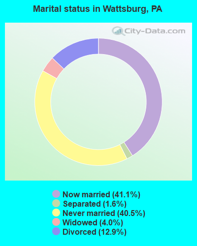
- Never married: 40.5%
- Now married: 41.1%
- Separated: 1.6%
- Widowed: 4.0%
- Divorced: 12.9%
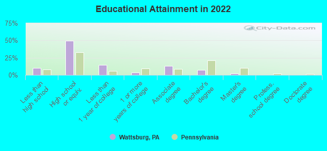
For population 25 years and over in Wattsburg:
- High school or higher: 88.6%
- Bachelor's degree or higher: 9.7%
- Graduate or professional degree: 2.0%
- Unemployed: 7.0%
- Mean travel time to work (commute): 25.7 minutes
| Here: | 6.1 |
| Pennsylvania average: | 11.4 |
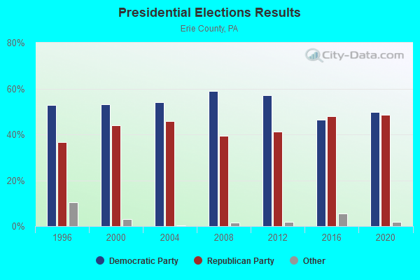
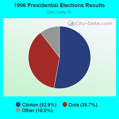
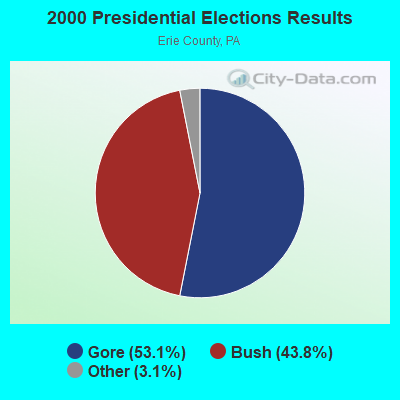
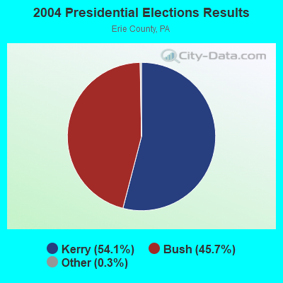
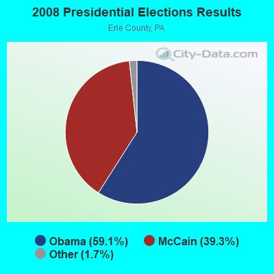
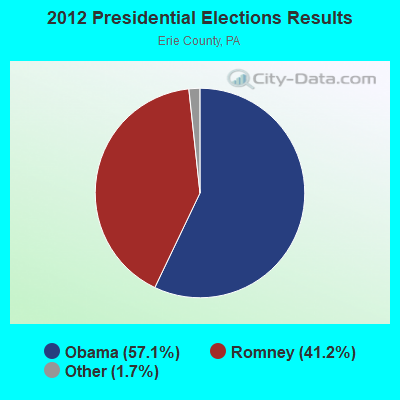
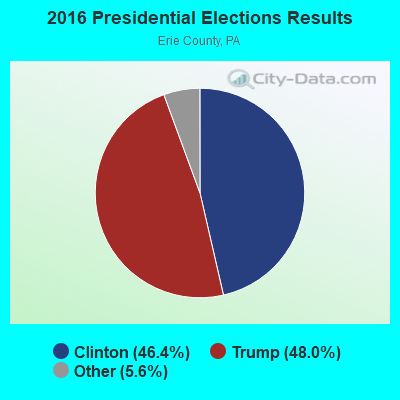
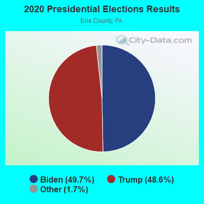
Graphs represent county-level data. Detailed 2008 Election Results
Religion statistics for Wattsburg, PA (based on Erie County data)
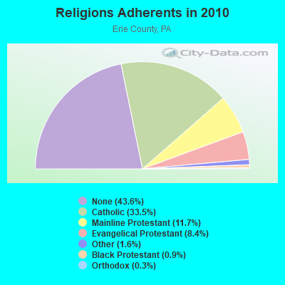
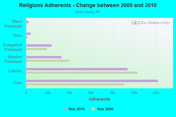
| Religion | Adherents | Congregations |
|---|---|---|
| Catholic | 93,998 | 40 |
| Mainline Protestant | 32,928 | 111 |
| Evangelical Protestant | 23,687 | 110 |
| Other | 4,429 | 28 |
| Black Protestant | 2,423 | 16 |
| Orthodox | 815 | 7 |
| None | 122,286 | - |
Food Environment Statistics:
| Erie County: | 1.65 / 10,000 pop. |
| State: | 2.04 / 10,000 pop. |
| This county: | 0.11 / 10,000 pop. |
| Pennsylvania: | 0.09 / 10,000 pop. |
| Erie County: | 0.93 / 10,000 pop. |
| Pennsylvania: | 0.88 / 10,000 pop. |
| Here: | 2.90 / 10,000 pop. |
| Pennsylvania: | 2.52 / 10,000 pop. |
| Erie County: | 6.98 / 10,000 pop. |
| Pennsylvania: | 7.12 / 10,000 pop. |
| Erie County: | 9.2% |
| Pennsylvania: | 9.1% |
| Here: | 29.8% |
| Pennsylvania: | 27.2% |
| Here: | 12.7% |
| Pennsylvania: | 11.5% |
Health and Nutrition:
| This city: | 43.9% |
| Pennsylvania: | 50.2% |
| Wattsburg: | 34.4% |
| Pennsylvania: | 47.1% |
| This city: | 27.7 |
| Pennsylvania: | 28.7 |
| This city: | 17.6% |
| State: | 20.8% |
| Wattsburg: | 5.8% |
| Pennsylvania: | 10.9% |
| Wattsburg: | 6.7 |
| Pennsylvania: | 6.8 |
| This city: | 26.1% |
| State: | 34.3% |
| This city: | 51.4% |
| State: | 56.2% |
| This city: | 74.0% |
| Pennsylvania: | 78.3% |
More about Health and Nutrition of Wattsburg, PA Residents
| Local government employment and payroll (March 2022) | |||||
| Function | Full-time employees | Monthly full-time payroll | Average yearly full-time wage | Part-time employees | Monthly part-time payroll |
|---|---|---|---|---|---|
| Other Government Administration | 0 | $0 | 7 | $395 | |
| Financial Administration | 0 | $0 | 1 | $894 | |
| Totals for Government | 0 | $0 | 8 | $1,288 | |
Wattsburg government finances - Expenditure in 2017 (per resident):
- Current Operations - Water Utilities: $51,000 ($147.40)
General - Other: $40,000 ($115.61)
Regular Highways: $28,000 ($80.92)
Judicial and Legal Services: $23,000 ($66.47)
Central Staff Services: $23,000 ($66.47)
Parks and Recreation: $12,000 ($34.68)
Financial Administration: $7,000 ($20.23)
General Public Buildings: $7,000 ($20.23)
Local Fire Protection: $4,000 ($11.56)
- General - Interest on Debt: $20,000 ($57.80)
- Other Capital Outlay - Water Utilities: $4,000 ($11.56)
- Total Salaries and Wages: $15,000 ($43.35)
Wattsburg government finances - Revenue in 2017 (per resident):
- Local Intergovernmental - Other: $24,000 ($69.36)
- Miscellaneous - General Revenue - Other: $2,000 ($5.78)
Donations From Private Sources: $1,000 ($2.89)
Fines and Forfeits: $1,000 ($2.89)
- Revenue - Water Utilities: $86,000 ($248.55)
- State Intergovernmental - Highways: $24,000 ($69.36)
Other: $6,000 ($17.34)
General Local Government Support: $1,000 ($2.89)
- Tax - Property: $40,000 ($115.61)
Individual Income: $39,000 ($112.72)
Occupation and Business License - Other: $1,000 ($2.89)
Wattsburg government finances - Debt in 2017 (per resident):
- Long Term Debt - Beginning Outstanding - Unspecified Public Purpose: $833,000 ($2407.51)
Outstanding Unspecified Public Purpose: $817,000 ($2361.27)
Retired Unspecified Public Purpose: $16,000 ($46.24)
Wattsburg government finances - Cash and Securities in 2017 (per resident):
- Other Funds - Cash and Securities: $225,000 ($650.29)
3.04% of this county's 2021 resident taxpayers lived in other counties in 2020 ($50,429 average adjusted gross income)
| Here: | 3.04% |
| Pennsylvania average: | 5.27% |
0.02% of residents moved from foreign countries ($354 average AGI)
Erie County: 0.02% Pennsylvania average: 0.01%
Top counties from which taxpayers relocated into this county between 2020 and 2021:
| from Crawford County, PA | |
| from Allegheny County, PA | |
| from Chautauqua County, NY |
Strongest AM radio stations in Wattsburg:
- WFNN (1330 AM; 5 kW; ERIE, PA; Owner: NM LICENSING, LLC)
- WRIE (1260 AM; 5 kW; ERIE, PA; Owner: REGENT LICENSEE OF ERIE, INC.)
- WWCB (1370 AM; 1 kW; CORRY, PA; Owner: CORRY COMMUNICATIONS CORPORATION)
- WWKB (1520 AM; 50 kW; BUFFALO, NY; Owner: ENTERCOM BUFFALO LICENSE, LLC)
- KDKA (1020 AM; 50 kW; PITTSBURGH, PA; Owner: INFINITY BROADCASTING OPERATIONS, INC.)
- WKNR (850 AM; 50 kW; CLEVELAND, OH; Owner: CARON BROADCASTING, INC.)
- WTAM (1100 AM; 50 kW; CLEVELAND, OH; Owner: JACOR BROADCASTING CORPORATION)
- WHK (1220 AM; 50 kW; CLEVELAND, OH; Owner: CARON BROADCASTING, INC.)
- WEYZ (1530 AM; daytime; 1 kW; NORTH EAST, PA)
- WPSE (1450 AM; 1 kW; ERIE, PA; Owner: THE BOARD OF TRUSTEES OF PA STATE UN)
- WNAE (1310 AM; 5 kW; WARREN, PA; Owner: KINZUA BROADCASTING COMPANY)
- WJET (1400 AM; 1 kW; ERIE, PA; Owner: NM LICENSING, LLC)
- WWOW (1360 AM; 5 kW; CONNEAUT, OH; Owner: WWOW BROADCASTING, INC.)
Strongest FM radio stations in Wattsburg:
- WRTS (103.7 FM; ERIE, PA; Owner: NM LICENSING, LLC)
- WMCE (88.5 FM; ERIE, PA; Owner: MERCYHURST COLLEGE)
- WXKC (99.9 FM; ERIE, PA; Owner: REGENT LICENSEE OF ERIE, INC.)
- WRKT (100.9 FM; NORTH EAST, PA; Owner: NM LICENSING, LLC)
- WCTL (106.3 FM; UNION CITY, PA; Owner: INSPIRATION TIME, INC.)
- WFGO (94.7 FM; ERIE, PA; Owner: NM LICENSING, LLC)
- WQHZ (102.3 FM; ERIE, PA; Owner: REGENT LICENSEE OF ERIE, INC.)
- WQLN-FM (91.3 FM; ERIE, PA; Owner: PUBLIC B/C OF NW PENN. INC.)
- WXTA (97.9 FM; EDINBORO, PA; Owner: REGENT LICENSEE OF ERIE, INC.)
- WEFR (88.1 FM; ERIE, PA; Owner: FAMILY STATIONS, INC.)
- WXXO (104.5 FM; CAMBRIDGE SPRINGS, PA; Owner: FOREVER BROADCASTING, LLC)
- WKZA (106.9 FM; LAKEWOOD, NY; Owner: CROSS COUNTRY COMMUNICATIONS, LLC)
- WERG (89.9 FM; ERIE, PA; Owner: GANNON UNIVERSITY)
- WWSE (93.3 FM; JAMESTOWN, NY; Owner: MEDIA ONE GROUP, LLC)
- WUBJ (88.1 FM; JAMESTOWN, NY; Owner: STATE UNIVERSITY OF NEW YORK)
- WBKX (96.5 FM; FREDONIA, NY; Owner: CHADWICK BAY BROADCASTING CORPORATION)
- WNJA (89.7 FM; JAMESTOWN, NY; Owner: WESTERN NEW YORK PUBLIC B/CING ASSOC)
- WGYY (100.3 FM; MEADVILLE, PA; Owner: FOREVER BROADCASTING, LLC)
- WUSE (93.9 FM; FAIRVIEW, PA; Owner: NM LICENSING, LLC)
- W205BA (88.9 FM; JAMESTOWN, NY; Owner: BIBLE BROADCASTING NETWORK, INC.)
TV broadcast stations around Wattsburg:
- WICU-TV (Channel 12; ERIE, PA; Owner: SJL OF PENNSYLVANIA, INC.)
- WJET-TV (Channel 24; ERIE, PA; Owner: NEXSTAR BROADCASTING OF ERIE, L.L.C.)
- WSEE-TV (Channel 35; ERIE, PA; Owner: INITIAL BROADCASTING OF PENNSYLVANIA LICENSE SUBSIDIARY, LLC)
- WQLN (Channel 54; ERIE, PA; Owner: PUBLIC B/C OF NW PENN. INC.)
- WFXP (Channel 66; ERIE, PA; Owner: MISSION BROADCASTING, INC.)
- W48CH (Channel 48; ERIE, PA; Owner: TRINITY BROADCASTING NETWORK)
- WNYB (Channel 26; JAMESTOWN, NY; Owner: FAITH BROADCASTING NETWORK, INC.)
- W46BA (Channel 46; JAMESTOWN, NY; Owner: WESTERN NEW YORK PUBLIC B/CING.ASSN.)
- W60AC (Channel 60; FINDLEY LAKE, NY; Owner: WESTERN NEW YORK PUBLIC B/CING.ASSN.)
Wattsburg fatal accident list:
- National Bridge Inventory (NBI) Statistics
- 13Number of bridges
- 112ft / 33.6mTotal length
- $752,000Total costs
- 23,877Total average daily traffic
- 1,692Total average daily truck traffic
- 33,094Total future (year 2032) average daily traffic
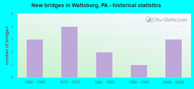
- New bridges - historical statistics
- 31960-1969
- 41970-1979
- 21980-1989
- 11990-1999
- 32000-2009
FCC Registered Cell Phone Towers:
1 (See the full list of FCC Registered Cell Phone Towers in Wattsburg)FCC Registered Antenna Towers:
24 (See the full list of FCC Registered Antenna Towers)FCC Registered Commercial Land Mobile Towers:
1- Hobson Hill Rd. (Lat: 42.001167 Lon: -79.875611), Structure height: 83 m, Call Sign: KPJ262,
Assigned Frequencies: 450.550 MHz, 455.550 MHz, Grant Date: 05/05/1992, Expiration Date: 08/01/1998, Cancellation Date: 09/24/2000, Registrant: Inspiration Time Inc., Rd#3, Union City, PA 16438
FCC Registered Broadcast Land Mobile Towers:
1- 11590 Hill Rd (Lat: 42.005611 Lon: -79.854778), Call Sign: KCJ679, Licensee ID: L00391827,
Assigned Frequencies: 33.8800 MHz, 33.9400 MHz, 33.9600 MHz, 33.9800 MHz, Grant Date: 09/22/2012, Expiration Date: 09/25/2022, Cancellation Date: 11/26/2022, Registrant: Wattsburg Hose Co, 14415 Main St, Wattsburg, PA 16442, Phone: (814) 739-9411, Fax: (814) 739-2929, Email:
FCC Registered Microwave Towers:
2- WATTSBURG, 8795 Fuller Road (Lat: 42.012611 Lon: -79.846833), Type: Gtower, Structure height: 91.4 m, Overall height: 95.7 m, Call Sign: WQRA611,
Assigned Frequencies: 10755.0 MHz, Grant Date: 02/28/2023, Expiration Date: 04/04/2033, Certifier: John Monday, Registrant: At&t Services, Inc., 208 S Akard St, 20f, Dallas, TX 75202, Phone: (855) 699-7073, Email:
- WATTSBURG E, 11341 Carter Hill Rd (Lat: 41.989472 Lon: -79.737694), Type: Mast, Structure height: 59.4 m, Overall height: 60.6 m, Call Sign: WRCH731,
Assigned Frequencies: 10795.0 MHz, 6063.80 MHz, Grant Date: 10/04/2018, Expiration Date: 10/04/2028, Certifier: John Grappy, Registrant: Mcm Consulting Group, Inc., 320 Innovations Blvd. Suite 210, State College, PA 16803, Phone: (412) 995-8196, Email:
FCC Registered Amateur Radio Licenses:
16 (See the full list of FCC Registered Amateur Radio Licenses in Wattsburg)FAA Registered Aircraft:
1- Aircraft: CESSNA 182K (Category: Land, Seats: 4, Weight: Up to 12,499 Pounds, Speed: 119 mph), Engine: CONT MOTOR O-470 SERIES (230 HP) (Reciprocating)
N-Number: 8051Q, N8051Q, N-8051Q, Serial Number: 18258064, Year manufactured: 1967, Airworthiness Date: 03/17/1967, Certificate Issue Date: 12/03/2020
Registrant (Individual): Maggie Michael, 10212 Kimball Rd, Wattsburg, PA 16442
Deregistered: Yes
| Home Mortgage Disclosure Act Aggregated Statistics For Year 2004 (Based on 1 partial tract) | ||
| C) Refinancings | ||
|---|---|---|
| Number | Average Value | |
| LOANS ORIGINATED | 1 | $49,380 |
| APPLICATIONS APPROVED, NOT ACCEPTED | 0 | $0 |
| APPLICATIONS DENIED | 0 | $0 |
| APPLICATIONS WITHDRAWN | 0 | $0 |
| FILES CLOSED FOR INCOMPLETENESS | 0 | $0 |
Detailed HMDA statistics for the following Tracts: 0118.01
| Most common first names in Wattsburg, PA among deceased individuals | ||
| Name | Count | Lived (average) |
|---|---|---|
| Charles | 15 | 73.8 years |
| John | 15 | 67.6 years |
| Robert | 14 | 63.8 years |
| George | 11 | 74.6 years |
| James | 10 | 54.6 years |
| Anna | 9 | 82.1 years |
| Frank | 9 | 78.3 years |
| Mary | 8 | 83.2 years |
| Dorothy | 8 | 72.3 years |
| Richard | 8 | 71.1 years |
| Most common last names in Wattsburg, PA among deceased individuals | ||
| Last name | Count | Lived (average) |
|---|---|---|
| Johnson | 10 | 77.3 years |
| Allen | 8 | 63.4 years |
| Orton | 8 | 75.0 years |
| Yost | 8 | 80.4 years |
| Phillips | 7 | 76.6 years |
| Skinner | 7 | 63.3 years |
| Brumagin | 6 | 83.4 years |
| Smith | 6 | 64.8 years |
| May | 6 | 81.8 years |
| Hall | 5 | 79.6 years |
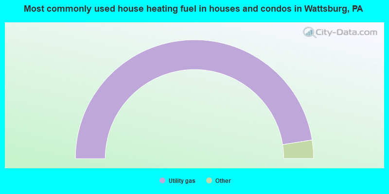
- 95.0%Utility gas
- 3.0%Fuel oil, kerosene, etc.
- 2.0%No fuel used
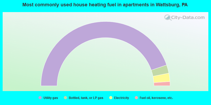
- 89.6%Utility gas
- 4.2%Bottled, tank, or LP gas
- 4.2%Electricity
- 2.1%Fuel oil, kerosene, etc.
Wattsburg compared to Pennsylvania state average:
- Median household income below state average.
- Median house value significantly below state average.
- Unemployed percentage below state average.
- Black race population percentage significantly below state average.
- Hispanic race population percentage significantly below state average.
- Median age below state average.
- Foreign-born population percentage significantly below state average.
- Length of stay since moving in significantly above state average.
- Number of college students below state average.
- Percentage of population with a bachelor's degree or higher significantly below state average.

|
|
Total of 21 patent applications in 2008-2024.