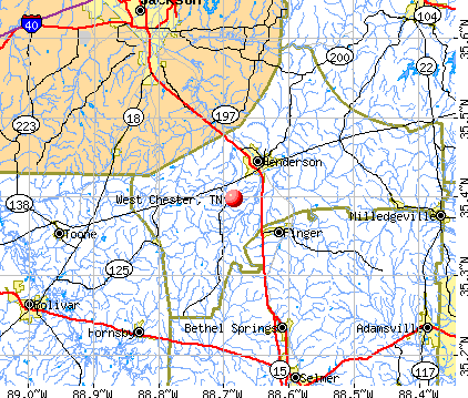
West Chester, Tennessee
Submit your own pictures of this place and show them to the world
- OSM Map
- General Map
- Google Map
- MSN Map
| Males: 5,188 | |
| Females: 5,652 |
| Median resident age: | 32.6 years |
| Tennessee median age: | 35.9 years |
Zip code: 38340
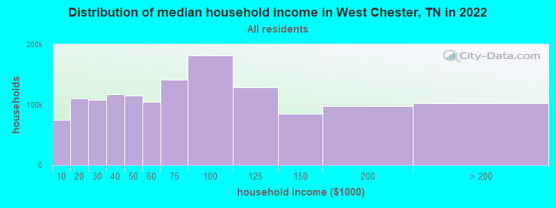
| West Chester: | $59,568 |
| TN: | $65,254 |
Estimated per capita income in 2022: $25,789 (it was $16,096 in 2000)
West Chester CCD income, earnings, and wages data
Estimated median house or condo value in 2022: $164,230 (it was $70,200 in 2000)
| West Chester: | $164,230 |
| TN: | $284,800 |
Mean prices in 2022: all housing units: $178,819; detached houses: $197,312; mobile homes: $78,691
Detailed information about poverty and poor residents in West Chester, TN
Compare current foreclosures near West Chester, TN:
| Photo | Address | Area | Beds / Baths | Price | Details |
|---|---|---|---|---|---|

|
#1
Diggs Rd
Pinson, TN 38366
|
1,368 sq. feet
|
2 baths 3 beds |
$162,900
|
show details |

|
#2
Beech Bluff Rd
Jackson, TN 38301
|
2,297 sq. feet
|
3 baths 4 beds |
show details | |

|
#3
Highway 200
Huron, TN 38345
|
2,597 sq. feet
|
2 baths 4 beds |
show details | |

|
#4
Preston St
Jackson, TN 38301
|
1,306 sq. feet
|
1 baths - beds |
show details | |

|
#5
Village Way
Henderson, TN 38340
|
- sq. feet
|
2 baths - beds |
show details | |

|
#6
Harmony Ln
Henderson, TN 38340
|
1,730 sq. feet
|
2 baths - beds |
show details | |

|
#7
Good Hope Church Rd
Adamsville, TN 38310
|
1,072 sq. feet
|
1 baths - beds |
show details | |

|
#8
Riverside Dr
Jackson, TN 38301
|
1,386 sq. feet
|
2 baths - beds |
show details | |

|
#9
Gobelet Rd
Medon, TN 38356
|
1,356 sq. feet
|
2 baths - beds |
show details | |

|
#10
Harts Bridge Rd
Jackson, TN 38301
|
2,537 sq. feet
|
2 baths - beds |
show details |
| Photo | Address | Area | Beds / Baths | Price | Details |
|---|---|---|---|---|---|

|
#11
Camellia Dr
Jackson, TN 38301
|
1,916 sq. feet
|
2 baths - beds |
show details | |

|
#12
Dustin Dr
Jackson, TN 38301
|
1,403 sq. feet
|
2 baths - beds |
show details | |

|
#13
Dustin Dr
Jackson, TN 38301
|
1,201 sq. feet
|
2 baths - beds |
show details | |

|
#14
Rochelle Rd
Jackson, TN 38301
|
945 sq. feet
|
1 baths - beds |
show details | |

|
#15
Horton Rd
Enville, TN 38332
|
1,288 sq. feet
|
2 baths - beds |
show details | |

|
#16
Main St
Enville, TN 38332
|
1,600 sq. feet
|
2 baths - beds |
show details | |

|
#17
Church St
Hornsby, TN 38044
|
1,296 sq. feet
|
1 baths - beds |
show details | |

|
#18
Farwell St
Jackson, TN 38301
|
1,654 sq. feet
|
1 baths - beds |
show details | |

|
#19
4th St
Jackson, TN 38301
|
1,456 sq. feet
|
2 baths - beds |
show details | |

|
#20
S Massachusetts St
Jackson, TN 38301
|
1,508 sq. feet
|
1 baths - beds |
show details |
| Photo | Address | Area | Beds / Baths | Price | Details |
|---|---|---|---|---|---|

|
#21
Riverside Dr
Jackson, TN 38301
|
3,058 sq. feet
|
3 baths - beds |
show details | |

|
#22
Malesus Heights Dr
Jackson, TN 38301
|
1,933 sq. feet
|
2 baths - beds |
show details | |

|
#23
Harts Bridge Rd
Jackson, TN 38301
|
844 sq. feet
|
1 baths - beds |
show details | |

|
#24
Seavers Rd
Jackson, TN 38301
|
1,056 sq. feet
|
1 baths - beds |
show details | |

|
#25
Barham Ln
Henderson, TN 38340
|
1,344 sq. feet
|
1 baths - beds |
show details | |

|
#26
Old Pinson Rd
Jackson, TN 38301
|
1,560 sq. feet
|
2 baths - beds |
show details | |

|
#27
Parkburg Rd
Jackson, TN 38301
|
770 sq. feet
|
1 baths - beds |
show details | |

|
#28
Diamond Grove Rd
Beech Bluff, TN 38313
|
2,040 sq. feet
|
2 baths - beds |
show details | |

|
#29
Parkburg Rd
Medon, TN 38356
|
1,394 sq. feet
|
1 baths - beds |
show details | |

|
#30
Seavers Rd
Jackson, TN 38301
|
1,976 sq. feet
|
1 baths - beds |
show details |
| Photo | Address | Area | Beds / Baths | Price | Details |
|---|---|---|---|---|---|

|
#31
Buena Vista Rd
Bethel Springs, TN 38315
|
864 sq. feet
|
1 baths - beds |
show details | |

|
#32
Perry Switch Rd
Jackson, TN 38301
|
676 sq. feet
|
1 baths - beds |
show details | |

|
#33
Powell Chapel Rd
Hornsby, TN 38044
|
1,356 sq. feet
|
1 baths - beds |
show details | |

|
#34
Buena Vista Rd
Bethel Springs, TN 38315
|
1,413 sq. feet
|
2 baths - beds |
show details | |

|
#35
Watlington Rd
Jackson, TN 38301
|
1,801 sq. feet
|
2 baths - beds |
show details | |

|
#36
Timberhill Dr
Jackson, TN 38301
|
2,162 sq. feet
|
2 baths - beds |
show details | |

|
#37
Oakwood Dr
Jackson, TN 38301
|
1,194 sq. feet
|
1 baths - beds |
show details | |

|
#38
Benson Ln
Jackson, TN 38301
|
1,152 sq. feet
|
2 baths - beds |
show details | |

|
#39
Bellmeade Dr
Jackson, TN 38301
|
1,300 sq. feet
|
2 baths - beds |
show details | |

|
#40
Deep Gap Rd
Jackson, TN 38301
|
932 sq. feet
|
1 baths - beds |
show details |
| Photo | Address | Area | Beds / Baths | Price | Details |
|---|---|---|---|---|---|

|
#41
Old Pinson Rd
Jackson, TN 38301
|
1,387 sq. feet
|
2 baths - beds |
show details | |

|
#42
Leapwood Enville Rd
Adamsville, TN 38310
|
1,792 sq. feet
|
2 baths - beds |
show details | |

|
#43
Mifflin Rd
Jackson, TN 38301
|
875 sq. feet
|
1 baths - beds |
show details | |

|
#44
Cane Creek Rd
Jackson, TN 38301
|
1,308 sq. feet
|
2 baths - beds |
show details | |

|
#45
N 5th St
Selmer, TN 38375
|
1,231 sq. feet
|
1 baths - beds |
show details | |

|
#46
Lenoir Ave
Jackson, TN 38301
|
1,008 sq. feet
|
1 baths - beds |
show details | |

|
#47
Arrowhead St
Jackson, TN 38301
|
960 sq. feet
|
1 baths - beds |
show details | |

|
#48
Eastview Ave
Jackson, TN 38301
|
1,062 sq. feet
|
1 baths - beds |
show details | |

|
#49
Hines Gin Rd
Selmer, TN 38375
|
2,153 sq. feet
|
2 baths - beds |
show details | |

|
Check over 1 million property listings on Foreclosure.com!
|
browse all offers | |||

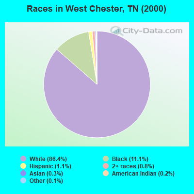
- 9,07186.4%White alone
- 1,16211.1%Black alone
- 1171.1%Hispanic
- 870.8%Two or more races
- 290.3%Asian alone
- 200.2%American Indian alone
- 110.1%Other race alone
Races in West Chester detailed stats: ancestries, foreign born residents, place of birth
 Recent articles from our blog. Our writers, many of them Ph.D. graduates or candidates, create easy-to-read articles on a wide variety of topics.
Current Local Time: CST time zone
Land area: 139.9 square miles.
Population density: 77 people per square mile (very low).

| West Chester CCD: | 0.6% ($443) |
| Tennessee: | 0.8% ($715) |
Nearest city with pop. 50,000+: Jackson, TN  (18.0 miles , pop. 59,643).
Nearest city with pop. 200,000+: Memphis, TN (75.2 miles , pop. 650,100).
Nearest city with pop. 1,000,000+: Chicago, IL (449.0 miles , pop. 2,896,016).
Nearest cities:
), ), ), ), Latitude: 35.40 N, Longitude: 88.68 W
Area code commonly used in this area: 731

| Here: | 2.9% |
| Tennessee: | 3.0% |
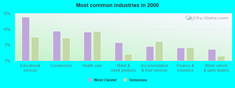
- Educational services (13.9%)
- Construction (9.4%)
- Health care (9.1%)
- Metal & metal products (5.8%)
- Accommodation & food services (4.5%)
- Finance & insurance (4.1%)
- Motor vehicle & parts dealers (3.6%)
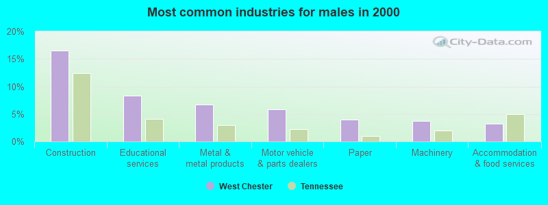
- Construction (16.6%)
- Educational services (8.3%)
- Metal & metal products (6.8%)
- Motor vehicle & parts dealers (5.8%)
- Paper (4.0%)
- Machinery (3.7%)
- Accommodation & food services (3.2%)
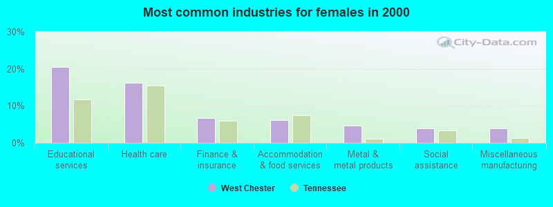
- Educational services (20.6%)
- Health care (16.2%)
- Finance & insurance (6.7%)
- Accommodation & food services (6.1%)
- Metal & metal products (4.7%)
- Social assistance (3.8%)
- Miscellaneous manufacturing (3.8%)
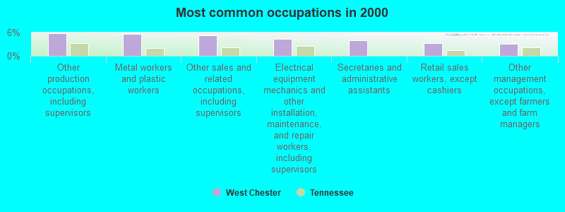
- Other production occupations, including supervisors (5.9%)
- Metal workers and plastic workers (5.6%)
- Other sales and related occupations, including supervisors (5.2%)
- Electrical equipment mechanics and other installation, maintenance, and repair workers, including supervisors (4.3%)
- Secretaries and administrative assistants (4.0%)
- Retail sales workers, except cashiers (3.3%)
- Other management occupations, except farmers and farm managers (3.2%)
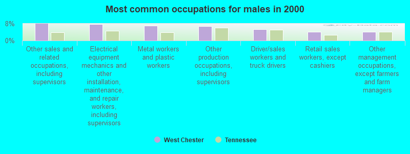
- Other sales and related occupations, including supervisors (7.9%)
- Electrical equipment mechanics and other installation, maintenance, and repair workers, including supervisors (7.7%)
- Metal workers and plastic workers (7.1%)
- Other production occupations, including supervisors (6.8%)
- Driver/sales workers and truck drivers (5.3%)
- Retail sales workers, except cashiers (4.2%)
- Other management occupations, except farmers and farm managers (4.1%)
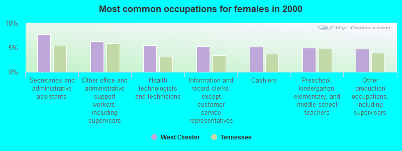
- Secretaries and administrative assistants (7.7%)
- Other office and administrative support workers, including supervisors (6.3%)
- Health technologists and technicians (5.5%)
- Information and record clerks, except customer service representatives (5.2%)
- Cashiers (5.1%)
- Preschool, kindergarten, elementary, and middle school teachers (4.9%)
- Other production occupations, including supervisors (4.8%)
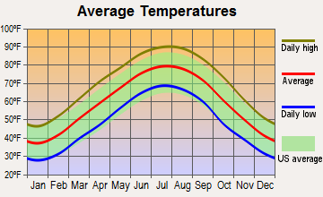
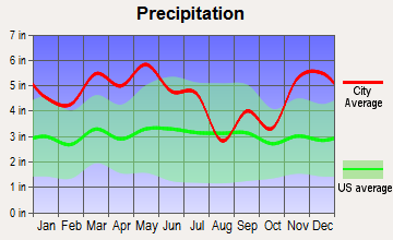
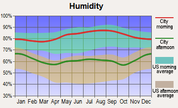
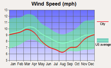
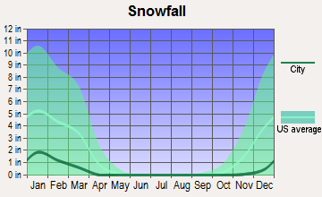
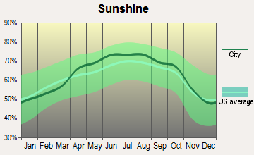
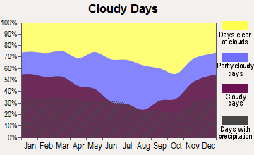
Average climate in West Chester, Tennessee
Based on data reported by over 4,000 weather stations
(lower is better)
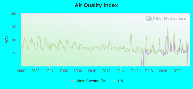
Air Quality Index (AQI) level in 2022 was 64.2. This is about average.
| City: | 64.2 |
| U.S.: | 72.6 |
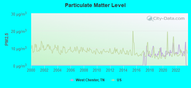
Particulate Matter (PM2.5) [µg/m3] level in 2022 was 8.18. This is about average. Closest monitor was 16.5 miles away from the city center.
| City: | 8.18 |
| U.S.: | 8.11 |
Tornado activity:
West Chester-area historical tornado activity is slightly above Tennessee state average. It is 92% greater than the overall U.S. average.
On 1/17/1999, a category F4 (max. wind speeds 207-260 mph) tornado 16.1 miles away from the West Chester place center killed 6 people and injured 106 people and caused $10 million in damages.
On 4/3/1956, a category F4 tornado 17.5 miles away from the place center killed 3 people and injured 60 people and caused between $500,000 and $5,000,000 in damages.
Earthquake activity:
West Chester-area historical earthquake activity is significantly above Tennessee state average. It is 308% greater than the overall U.S. average.On 3/25/1976 at 00:41:20, a magnitude 5.0 (4.9 MB, 5.0 LG, Class: Moderate, Intensity: VI - VII) earthquake occurred 94.0 miles away from West Chester center
On 5/4/1991 at 01:18:54, a magnitude 5.0 (4.4 MB, 4.6 LG, 5.0 LG, Depth: 3.1 mi) earthquake occurred 102.8 miles away from the city center
On 9/26/1990 at 13:18:51, a magnitude 5.0 (4.7 MB, 4.8 LG, 5.0 LG, Depth: 7.7 mi) earthquake occurred 131.3 miles away from West Chester center
On 4/18/2008 at 09:36:59, a magnitude 5.4 (5.1 MB, 4.8 MS, 5.4 MW, 5.2 MW) earthquake occurred 215.9 miles away from the city center
On 4/27/1989 at 16:47:49, a magnitude 4.7 (4.6 MB, 4.7 LG, 4.3 LG, Class: Light, Intensity: IV - V) earthquake occurred 74.0 miles away from West Chester center
On 4/18/2008 at 09:36:59, a magnitude 5.2 (5.2 MW, Depth: 8.9 mi) earthquake occurred 215.8 miles away from West Chester center
Magnitude types: regional Lg-wave magnitude (LG), body-wave magnitude (MB), surface-wave magnitude (MS), moment magnitude (MW)
Natural disasters:
The number of natural disasters in Chester County (12) is smaller than the US average (15).Major Disasters (Presidential) Declared: 10
Emergencies Declared: 1
Causes of natural disasters: Floods: 9, Storms: 9, Tornadoes: 5, Winds: 3, Flash Flood: 1, Hurricane: 1, Ice Storm: 1, Winter Storm: 1, Other: 1 (Note: some incidents may be assigned to more than one category).
Colleges/universities with over 2000 students nearest to West Chester:
- Jackson State Community College (about 19 miles; Jackson, TN; Full-time enrollment: 2,958)
- Union University (about 22 miles; Jackson, TN; FT enrollment: 4,051)
- Northeast Mississippi Community College (about 51 miles; Booneville, MS; FT enrollment: 3,024)
- Bethel University (about 53 miles; McKenzie, TN; FT enrollment: 5,878)
- Dyersburg State Community College (about 60 miles; Dyersburg, TN; FT enrollment: 2,211)
- The University of Tennessee-Martin (about 67 miles; Martin, TN; FT enrollment: 7,013)
- University of North Alabama (about 70 miles; Florence, AL; FT enrollment: 5,886)
Points of interest:
Notable locations in West Chester: Magic Valley Industrial Park (A), Lake Placid Camp (B), Henderson Industrial Park (C), Chester County Fire Department / Deanburg Volunteer Fire Department Station 540 (D), Chester County Fire Department Headquarters (E), Chester County Fire Department / Hearn Chapel Volunteer Fire Department Station 530 (F), Chester County Fire Department / Masseyville Volunteer Fire Department Station 550 (G), Henderson Fire Department Station 2 (H), Henderson City Hall (I), Chester County Nursing Home (J), Chester County Courthouse (K), Henderson Fire Department (L). Display/hide their locations on the map
Churches in West Chester include: Estes Church (A), Cool Springs Baptist Church (B), First Pentecostal Church (C), First United Methodist Church (D), Henderson Church of Christ (E), Little Hatchie Church (F), Bethel Baptist Church (G), Tillman Chapel (H), Antioch Baptist Church (I). Display/hide their locations on the map
Cemeteries: Hunter Cemetery (1), Hurst Cemetery (2), Wamble Cemetery (3), Chester County Memorial Garden (4), Weaver Cemetery (5), Alexander Cemetery (6), Pleasant Springs Cemetery (7). Display/hide their locations on the map
Reservoirs: Thomas Lake (A), Smith Pond (B), Deanburg Hills Lake (C), Lake Placid (D), King Lake (E), Scott Lake (F). Display/hide their locations on the map
Streams, rivers, and creeks: Dry Branch (A), Right Fork Kise Creek (B), Bear Creek (C), Webb Branch (D), Tar Creek (E), Sugar Creek (F), Melton Branch (G). Display/hide their locations on the map
Parks in West Chester include: Memorial Park (1), Dixie Youth Park (2). Display/hide their locations on the map
| This place: | 2.5 people |
| Tennessee: | 2.5 people |
| This place: | 57.5% |
| Whole state: | 69.8% |
| This place: | 3.8% |
| Whole state: | 4.2% |
Likely homosexual households (counted as self-reported same-sex unmarried-partner households)
- Lesbian couples: 0.2% of all households
- Gay men: 0.2% of all households
| This place: | 14.1% |
| Whole state: | 13.5% |
| This place: | 3.7% |
| Whole state: | 5.8% |
People in group quarters in West Chester in 2000:
- 935 people in college dormitories (includes college quarters off campus)
- 136 people in nursing homes
- 25 people in local jails and other confinement facilities (including police lockups)
For population 15 years and over in West Chester:
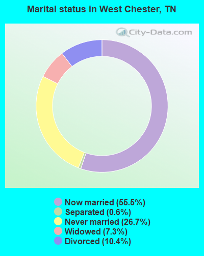
- Never married: 26.7%
- Now married: 55.5%
- Separated: 0.6%
- Widowed: 7.3%
- Divorced: 10.4%
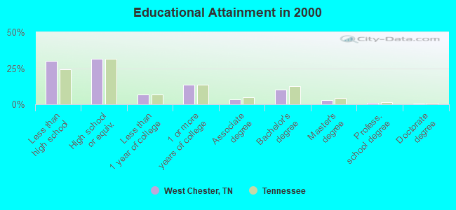
For population 25 years and over in West Chester:
- High school or higher: 69.8%
- Bachelor's degree or higher: 14.5%
- Graduate or professional degree: 4.2%
- Unemployed: 7.9%
- Mean travel time to work (commute): 24.5 minutes
| Here: | 13.2 |
| Tennessee average: | 13.3 |
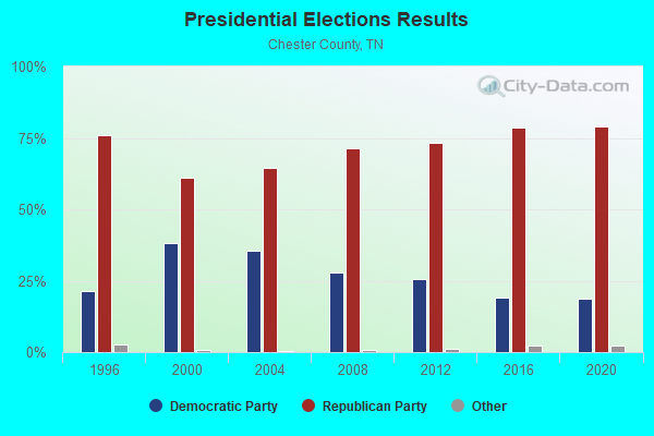
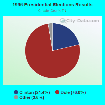
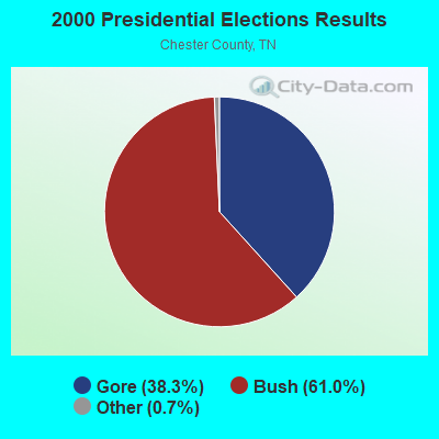
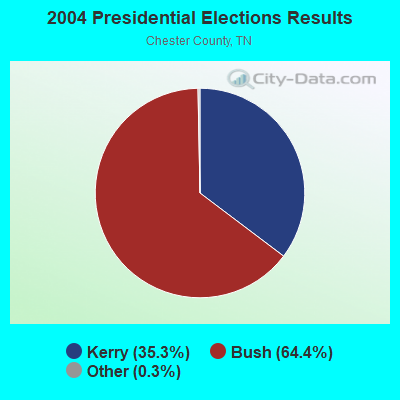
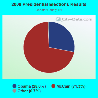
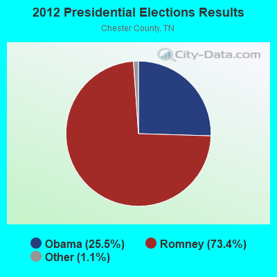
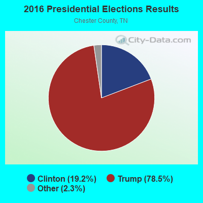
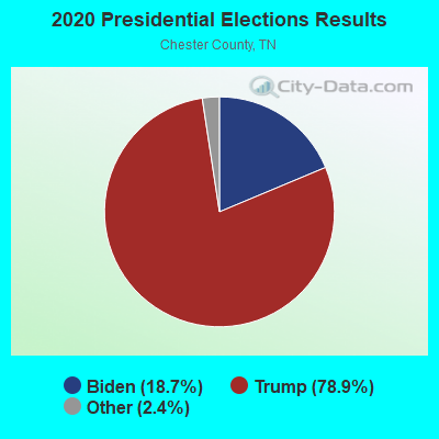
Graphs represent county-level data. Detailed 2008 Election Results
Religion statistics for West Chester, TN (based on Chester County data)
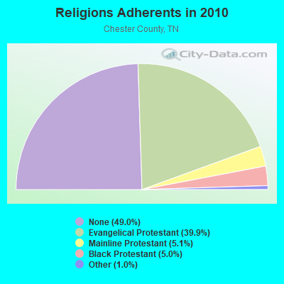
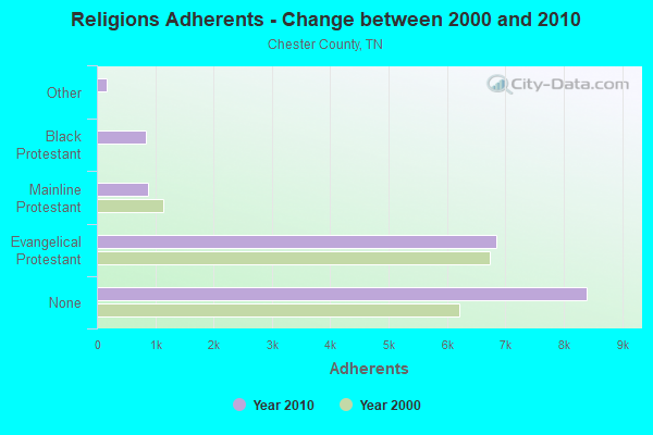
| Religion | Adherents | Congregations |
|---|---|---|
| Evangelical Protestant | 6,837 | 30 |
| Mainline Protestant | 869 | 9 |
| Black Protestant | 848 | 7 |
| Other | 176 | 3 |
| None | 8,401 | - |
Food Environment Statistics:
| This county: | 3.11 / 10,000 pop. |
| Tennessee: | 1.99 / 10,000 pop. |
| Here: | 4.97 / 10,000 pop. |
| Tennessee: | 5.16 / 10,000 pop. |
| Chester County: | 2.49 / 10,000 pop. |
| Tennessee: | 6.56 / 10,000 pop. |
| Chester County: | 13.1% |
| Tennessee: | 11.4% |
| Here: | 30.9% |
| Tennessee: | 30.2% |
| This county: | 11.3% |
| Tennessee: | 13.5% |
Strongest AM radio stations in West Chester:
- WCRV (640 AM; 50 kW; COLLIERVILLE, TN; Owner: BOTT BROADCASTING COMPANY/TENNESSEE)
- WTJS (1390 AM; 5 kW; JACKSON, TN; Owner: CAPSTAR TX LIMITED PARTNERSHIP)
- WDXI (1310 AM; 5 kW; JACKSON, TN; Owner: LIBERTY RADIO II, INC.)
- WGSF (1030 AM; 50 kW; MEMPHIS, TN; Owner: FLINN BROADCASTING CORPORATION)
- WDIA (1070 AM; 50 kW; MEMPHIS, TN; Owner: CLEAR CHANNEL BROADCASTING LICENSES, INC.)
- WMQM (1600 AM; 50 kW; LAKELAND, TN; Owner: WMQM, INC.)
- WSM (650 AM; 50 kW; NASHVILLE, TN; Owner: GAYLORD ENTERTAINMENT COMPANY)
- WCPC (940 AM; 50 kW; HOUSTON, MS; Owner: WCPC BROADCASTING CO., INC.)
- WDTM (1150 AM; daytime; 1 kW; SELMER, TN; Owner: RADIO STATION WDTM, INC)
- WKDA (1200 AM; 50 kW; NASHVILLE, TN; Owner: RADIO NASHVILLE, INC.)
- WNQM (1300 AM; 50 kW; NASHVILLE, TN; Owner: WNQM. INC.)
- WAMB (1160 AM; 50 kW; DONELSON, TN; Owner: GREAT SOUTHERN BROADCASTING COMPANY, INC.)
- WJOX (690 AM; 50 kW; BIRMINGHAM, AL; Owner: CITADEL BROADCASTING COMPANY)
Strongest FM radio stations in West Chester:
- WHHM-FM (107.7 FM; HENDERSON, TN; Owner: THOMAS RADIO, LLC)
- WFHC (91.5 FM; HENDERSON, TN; Owner: FREED-HARDEMAN UNIVERSITY)
- WFKX (95.7 FM; HENDERSON, TN; Owner: THOMAS RADIO, LLC)
- WMXX-FM (103.1 FM; JACKSON, TN; Owner: GERALD W. HUNT)
- WTNV (104.1 FM; JACKSON, TN; Owner: CAPSTAR TX LIMITED PARTNERSHIP)
- WXOQ (105.5 FM; SELMER, TN; Owner: GERALD W. HUNT)
- WKNP (90.1 FM; JACKSON, TN; Owner: MID-SOUTH PUBLIC COMMUNICTNS FOUNDTN)
- WIGH (88.7 FM; LEXINGTON, TN; Owner: AMERICAN FAMILY ASSOCIATION)
- WSIB (93.9 FM; SELMER, TN; Owner: WDTM INC)
- WYNU (92.3 FM; MILAN, TN; Owner: CAPSTAR TX LIMITED PARTNERSHIP)
- WOJG (94.7 FM; BOLIVAR, TN; Owner: JOHNNY W. SHAW & OPAL J. SHAW)
- WNWS-FM (101.5 FM; JACKSON, TN; Owner: RADIOCORP OF JACKSON, INC.)
- WMOD (96.7 FM; BOLIVAR, TN; Owner: WMOD, INC.)
- WWYN (106.9 FM; MCKENZIE, TN; Owner: RAINBOW MEDIA, INC.)
- WYDL (100.7 FM; MIDDLETON, TN; Owner: FLINN BROADCASTING CORPORATION)
- WOWL (91.9 FM; BURNSVILLE, MS; Owner: SOUTHERN COMMUNITY SERVICES, INC)
TV broadcast stations around West Chester:
- WBBJ-TV (Channel 7; JACKSON, TN; Owner: TENNESSEE BROADCASTING PARTNERS)
- W25BY (Channel 25; JACKSON, TN; Owner: MS COMMUNICATIONS, LLC)
- W38BY (Channel 38; JACKSON, TN; Owner: MS COMMUNICATIONS, LLC)
- W54BU (Channel 54; JACKSON, TN; Owner: MS COMMUNICATIONS, LLC)
- W22BR (Channel 22; JACKSON, TN; Owner: MS COMMUNICATIONS, LLC)
- W52CZ (Channel 52; JACKSON, TN; Owner: MS COMMUNICATIONS, LLC)
- W64BZ (Channel 64; JACKSON, TN; Owner: MS COMMUNICATIONS, LLC)
- WJTE-LP (Channel 19; JACKSON, TN; Owner: TIGER EYE BROADCASTING CORPORATION)
- W26CJ (Channel 26; JACKSON, TN; Owner: MS COMMUNICATIONS, LLC)
- W35AH (Channel 35; JACKSON, TN; Owner: TRINITY BROADCASTING NETWORK)
- WLJT (Channel 11; LEXINGTON, TN; Owner: WEST TENNESSEE PUBLIC TV COUNCIL, INC)
- W34BU (Channel 34; ACTON, TN; Owner: MS COMMUNICATIONS, LLC)
- WJKT (Channel 16; JACKSON, TN; Owner: CLEAR CHANNEL BROADCASTING LICENSES, INC.)
- W06AW (Channel 6; SELMER, TN; Owner: WDTM, INC.)
- W46CG (Channel 46; JACKSON, TN; Owner: MS COMMUNICATIONS, LLC)
- W62CK (Channel 62; ACTON, TN; Owner: MS COMMUNICATIONS, LLC)
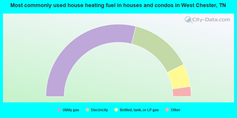
- 57.7%Utility gas
- 27.7%Electricity
- 10.2%Bottled, tank, or LP gas
- 3.0%Wood
- 1.1%Fuel oil, kerosene, etc.
- 0.4%Coal or coke
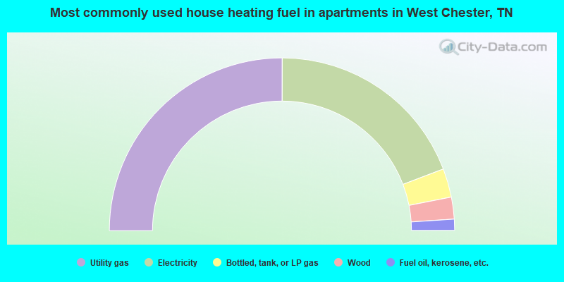
- 50.1%Utility gas
- 38.4%Electricity
- 5.4%Bottled, tank, or LP gas
- 4.1%Wood
- 2.1%Fuel oil, kerosene, etc.
West Chester compared to Tennessee state average:
- Median house value below state average.
- Unemployed percentage below state average.
- Hispanic race population percentage significantly below state average.
- Median age below state average.
- Foreign-born population percentage significantly below state average.
- Renting percentage significantly below state average.
- Length of stay since moving in significantly above state average.
- Number of rooms per house significantly below state average.
- House age significantly below state average.
- Institutionalized population percentage significantly above state average.
- Number of college students above state average.
West Chester on our top lists:
- #8 on the list of "Top 101 cities with largest percentage of females in industries: metal and metal products (population 5,000+)"
- #8 on the list of "Top 101 cities with largest percentage of males in industries: motor vehicle and parts dealers (population 5,000+)"
- #14 on the list of "Top 101 cities with largest percentage of females in occupations: metal workers and plastic workers (population 5,000+)"
- #20 on the list of "Top 101 cities with largest percentage of females in industries: truck transportation (population 5,000+)"
- #24 on the list of "Top 101 cities with largest percentage of males in occupations: other sales and related workers including supervisors (population 5,000+)"
- #29 on the list of "Top 101 cities with largest percentage of females in industries: electrical equipment, appliances, and components (population 5,000+)"
- #30 on the list of "Top 101 cities with largest percentage of females in occupations: material moving workers except supervisors and laborers and material movers, hand (population 5,000+)"
- #30 on the list of "Top 101 cities with largest percentage of males in occupations: secretaries and administrative assistants (population 5,000+)"
- #32 on the list of "Top 101 cities with largest percentage of females in occupations: communications equipment operators (population 5,000+)"
- #45 on the list of "Top 101 cities with largest percentage of females in industries: miscellaneous manufacturing (population 5,000+)"
- #51 on the list of "Top 101 cities with largest percentage of females in industries: lumber and other construction materials merchant wholesalers (population 5,000+)"
- #53 on the list of "Top 101 cities with largest percentage of females in industries: apparel (population 5,000+)"
- #53 on the list of "Top 101 cities with largest percentage of males in industries: paper (population 5,000+)"
- #61 on the list of "Top 101 cities with largest percentage of males in industries: plastics and rubber products (population 5,000+)"
- #70 on the list of "Top 101 cities with largest percentage of females in industries: recyclable material merchant wholesalers (population 5,000+)"
- #73 on the list of "Top 101 cities with largest percentage of males in industries: food (population 5,000+)"
- #74 on the list of "Top 101 cities with largest percentage of males in occupations: waiters and waitresses (population 5,000+)"
- #80 on the list of "Top 101 cities with largest percentage of males in industries: metal and metal products (population 5,000+)"
- #84 on the list of "Top 101 cities with largest percentage of males in industries: department and other general merchandise stores (population 5,000+)"
- #90 on the list of "Top 101 cities with largest percentage of males in industries: metals and minerals, except petroleum, merchant wholesalers (population 5,000+)"