West End, Washington
Submit your own pictures of this place and show them to the world
- OSM Map
- General Map
- Google Map
- MSN Map

| Males: 349 | |
| Females: 314 |
| Median resident age: | 32.9 years |
| Washington median age: | 35.3 years |
Zip code: 98331
| West End: | $34,473 |
| WA: | $91,306 |
Estimated per capita income in 2022: $22,788 (it was $10,960 in 2000)
West End CCD income, earnings, and wages data
Estimated median house or condo value in 2022: $281,243 (it was $81,900 in 2000)
| West End: | $281,243 |
| WA: | $569,500 |
Mean prices in 2022: all housing units: $569,027; detached houses: $615,312; townhouses or other attached units: $575,060; in 2-unit structures: $731,132; in 3-to-4-unit structures: $215,019; in 5-or-more-unit structures: $376,073; mobile homes: $236,484; occupied boats, rvs, vans, etc.: $134,887
Detailed information about poverty and poor residents in West End, WA


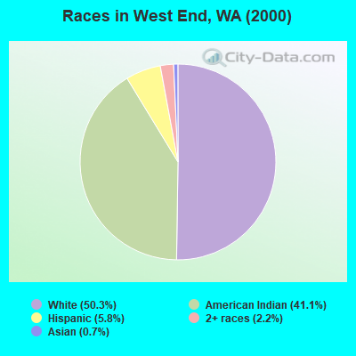
- 30150.3%White alone
- 24641.1%American Indian alone
- 355.8%Hispanic
- 132.2%Two or more races
- 40.7%Asian alone
Races in West End detailed stats: ancestries, foreign born residents, place of birth
 Recent articles from our blog. Our writers, many of them Ph.D. graduates or candidates, create easy-to-read articles on a wide variety of topics.
Current Local Time: PST time zone
Land area: 1110.9 square miles.
Population density: 0.6 people per square mile (very low).

| West End CCD: | 0.8% ($638) |
| Washington: | 1.2% ($1,915) |
Nearest city with pop. 50,000+: Shoreline, WA  (86.3 miles , pop. 53,025).
Nearest city with pop. 200,000+: Seattle, WA (86.9 miles , pop. 563,374).
Nearest city with pop. 1,000,000+: Los Angeles, CA (990.1 miles , pop. 3,694,820).
Nearest cities:
), ), ), Latitude: 47.72 N, Longitude: 124.19 W
Area code commonly used in this area: 360

| Here: | 5.8% |
| Washington: | 4.6% |
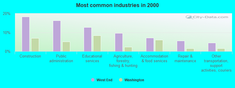
- Construction (18.3%)
- Public administration (16.2%)
- Educational services (12.7%)
- Agriculture, forestry, fishing & hunting (9.6%)
- Accommodation & food services (7.1%)
- Repair & maintenance (5.6%)
- Other transportation, support activities, couriers (4.6%)
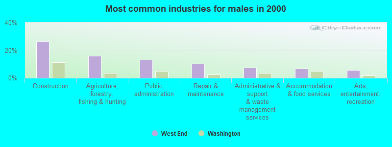
- Construction (26.4%)
- Agriculture, forestry, fishing & hunting (16.0%)
- Public administration (13.2%)
- Repair & maintenance (10.4%)
- Administrative & support & waste management services (7.5%)
- Accommodation & food services (6.6%)
- Arts, entertainment, recreation (5.7%)
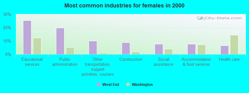
- Educational services (25.3%)
- Public administration (19.8%)
- Other transportation, support activities, couriers (9.9%)
- Construction (8.8%)
- Social assistance (7.7%)
- Accommodation & food services (7.7%)
- Health care (6.6%)
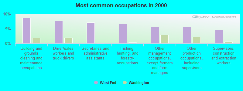
- Building and grounds cleaning and maintenance occupations (8.6%)
- Driver/sales workers and truck drivers (7.6%)
- Secretaries and administrative assistants (7.1%)
- Fishing, hunting, and forestry occupations (6.6%)
- Other management occupations, except farmers and farm managers (5.6%)
- Other production occupations, including supervisors (5.6%)
- Supervisors, construction and extraction workers (4.6%)
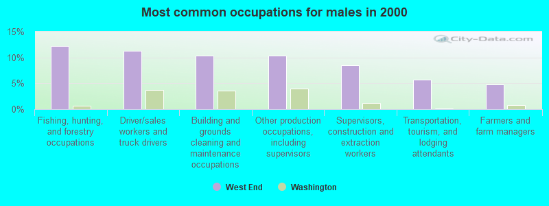
- Fishing, hunting, and forestry occupations (12.3%)
- Driver/sales workers and truck drivers (11.3%)
- Building and grounds cleaning and maintenance occupations (10.4%)
- Other production occupations, including supervisors (10.4%)
- Supervisors, construction and extraction workers (8.5%)
- Transportation, tourism, and lodging attendants (5.7%)
- Farmers and farm managers (4.7%)
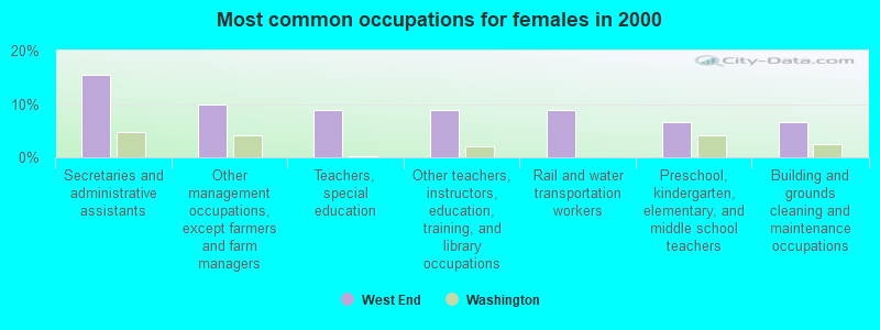
- Secretaries and administrative assistants (15.4%)
- Other management occupations, except farmers and farm managers (9.9%)
- Teachers, special education (8.8%)
- Other teachers, instructors, education, training, and library occupations (8.8%)
- Rail and water transportation workers (8.8%)
- Preschool, kindergarten, elementary, and middle school teachers (6.6%)
- Building and grounds cleaning and maintenance occupations (6.6%)
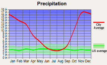
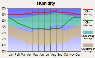
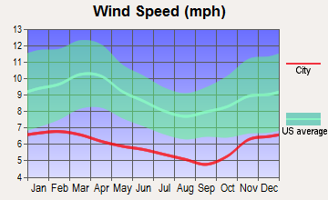
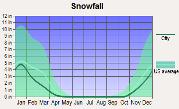
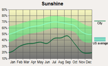
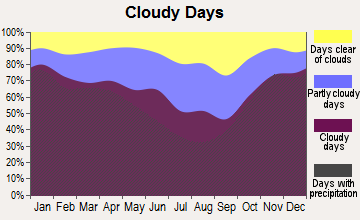
Average climate in West End, Washington
Based on data reported by over 4,000 weather stations

Earthquake activity:
West End-area historical earthquake activity is significantly above Washington state average. It is 1061% greater than the overall U.S. average.On 4/13/1949 at 19:55:42, a magnitude 7.0 (7.0 UK, Class: Major, Intensity: VIII - XII) earthquake occurred 85.6 miles away from West End center, causing $80,000,000 total damage
On 2/28/2001 at 18:54:32, a magnitude 6.8 (6.8 MD, Depth: 32.2 mi, Class: Strong, Intensity: VII - IX) earthquake occurred 79.2 miles away from the city center
On 2/28/2001 at 18:54:32, a magnitude 6.8 (6.5 MB, 6.6 MS, 6.8 MW) earthquake occurred 87.2 miles away from West End center, causing $2,000,000,000 total damage and $305,000,000 insured losses
On 4/29/1965 at 15:28:43, a magnitude 6.6 (6.6 UK) earthquake occurred 91.3 miles away from West End center, causing $28,000,000 total damage
On 7/3/1999 at 01:43:54, a magnitude 5.8 (5.4 MB, 5.5 MS, 5.8 MW, 5.3 ME, Depth: 25.2 mi, Class: Moderate, Intensity: VI - VII) earthquake occurred 64.0 miles away from West End center
On 1/31/1922 at 13:17:28, a magnitude 7.6 (7.6 UK) earthquake occurred 490.1 miles away from West End center
Magnitude types: body-wave magnitude (MB), duration magnitude (MD), energy magnitude (ME), surface-wave magnitude (MS), moment magnitude (MW)
Natural disasters:
The number of natural disasters in Jefferson County (21) is greater than the US average (15).Major Disasters (Presidential) Declared: 19
Emergencies Declared: 1
Causes of natural disasters: Floods: 14, Storms: 12, Mudslides: 9, Landslides: 8, Winds: 5, Winter Storms: 5, Tornadoes: 2, Earthquake: 1, Hurricane: 1, Snow: 1, Volcanic Eruption: 1, Other: 1 (Note: some incidents may be assigned to more than one category).
Colleges/universities with over 2000 students nearest to West End:
- Peninsula College (about 45 miles; Port Angeles, WA; Full-time enrollment: 2,012)
- The Evergreen State College (about 73 miles; Olympia, WA; FT enrollment: 4,613)
- Olympic College (about 74 miles; Bremerton, WA; FT enrollment: 6,158)
- South Puget Sound Community College (about 77 miles; Olympia, WA; FT enrollment: 3,981)
- Tacoma Community College (about 85 miles; Tacoma, WA; FT enrollment: 6,622)
- Pierce College at Fort Steilacoom (about 85 miles; Lakewood, WA; FT enrollment: 5,228)
- Seattle Pacific University (about 86 miles; Seattle, WA; FT enrollment: 3,897)
Points of interest:
Notable locations in West End: Lower Hoh Fire Camp (A), Twelve Mile Shelter (B), Trapper Shelter (C), North Fork Campground (D), Halfway House Campsite (E), Francis Creek Campsite (F), Low Divide Ranger Station (G), Graves Creek Ranger Station (H), Graves Creek Campground (I), North Fork Ranger Station (J), Chicago Camp (K), Camp Wilder (L), Kalaloch Campground (M), Bob Creek Shelter (N), Underground Passage (O), Big Flat Shelter (P), Glacier Meadow Ranger Station (Q), Copper Mine Botton Campground (R), Clearwater Honor Camp (S), Upper Clearwater Campground (T). Display/hide their locations on the map
Cemetery: Fletcher Cemetery (1). Display/hide its location on the map
Lakes: Lake Margaret (A), Reflection Lake (B), Kurtz Lake (C), Martins Lakes (D), Lake Sundown (E), Yahoo Lake (F), Lake Mary (G), Lake Dilly (H). Display/hide their locations on the map
Rivers and creeks: Big Creek (A), Bob Creek (B), Boulevard Creek (C), Braden Creek (D), Buckinghorse Creek (E), Bull Creek (F), Cannings Creek (G), Canyon Creek (H), Cedar Creek (I). Display/hide their locations on the map
Park in West End: Clearwater State Park (1). Display/hide its location on the map
Beaches: Boulder Beach (A), Ruby Beach (B). Display/hide their locations on the map
| This place: | 2.8 people |
| Washington: | 2.5 people |
| This place: | 67.6% |
| Whole state: | 64.4% |
| This place: | 13.3% |
| Whole state: | 7.7% |
Likely homosexual households (counted as self-reported same-sex unmarried-partner households)
- Lesbian couples: 0.0% of all households
- Gay men: 0.6% of all households
| This place: | 40.3% |
| Whole state: | 10.6% |
| This place: | 9.3% |
| Whole state: | 4.6% |
12 people in workers' group living quarters and job corps centers in 2010
For population 15 years and over in West End:
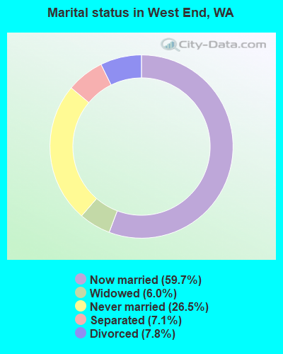
- Never married: 26.5%
- Now married: 59.7%
- Separated: 7.1%
- Widowed: 6.0%
- Divorced: 7.8%
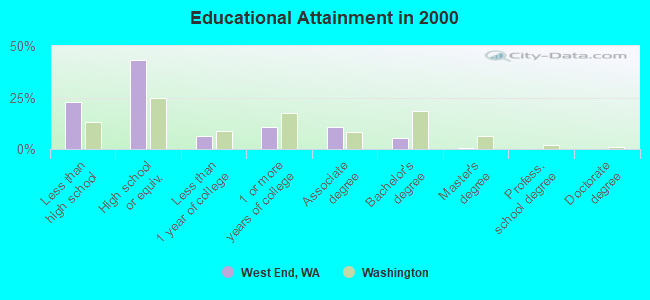
For population 25 years and over in West End:
- High school or higher: 77.2%
- Bachelor's degree or higher: 6.1%
- Graduate or professional degree: 0.5%
- Unemployed: 17.9%
- Mean travel time to work (commute): 19.1 minutes
| Here: | 9.0 |
| Washington average: | 11.3 |
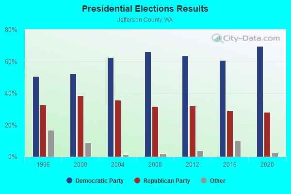
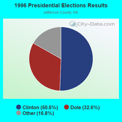
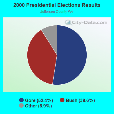
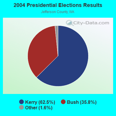
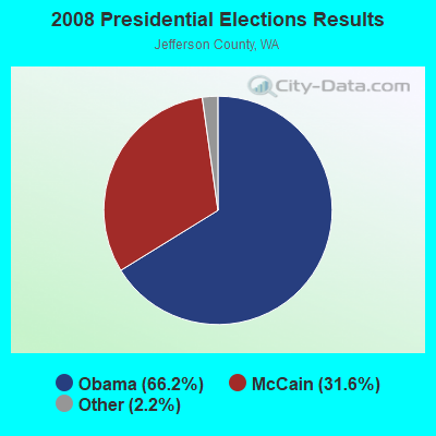
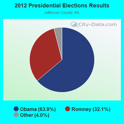
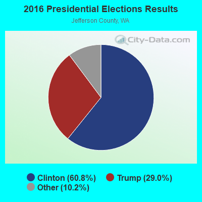
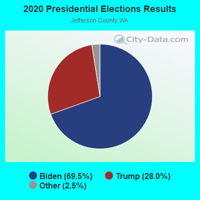
Graphs represent county-level data. Detailed 2008 Election Results
Religion statistics for West End, WA (based on Jefferson County data)
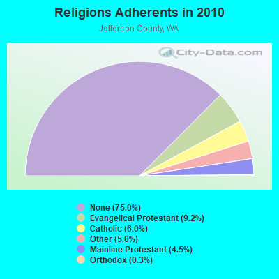
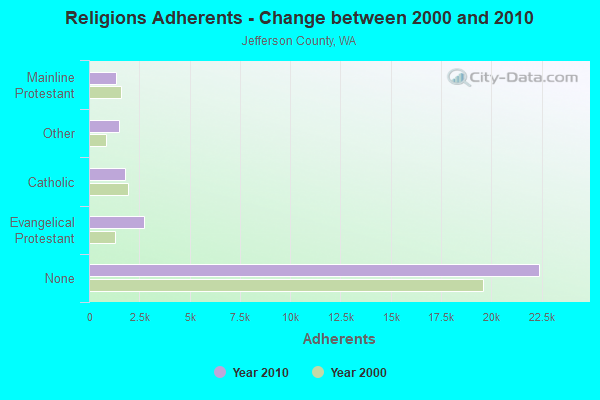
| Religion | Adherents | Congregations |
|---|---|---|
| Evangelical Protestant | 2,747 | 19 |
| Catholic | 1,786 | 1 |
| Other | 1,490 | 12 |
| Mainline Protestant | 1,351 | 9 |
| Orthodox | 100 | 1 |
| None | 22,398 | - |
Food Environment Statistics:
| Jefferson County: | 2.74 / 10,000 pop. |
| Washington: | 2.06 / 10,000 pop. |
| Jefferson County: | 1.37 / 10,000 pop. |
| Washington: | 1.18 / 10,000 pop. |
| Here: | 3.09 / 10,000 pop. |
| Washington: | 2.67 / 10,000 pop. |
| Jefferson County: | 15.43 / 10,000 pop. |
| Washington: | 8.26 / 10,000 pop. |
| Jefferson County: | 6.9% |
| Washington: | 7.7% |
| Jefferson County: | 20.8% |
| Washington: | 25.7% |
| Here: | 15.2% |
| Washington: | 13.9% |
Strongest AM radio stations in West End:
- KIRO (710 AM; 50 kW; SEATTLE, WA; Owner: ENTERCOM SEATTLE LICENSE, LLC)
- KGNW (820 AM; 50 kW; BURIEN-SEATTLE, WA; Owner: INSPIRATION MEDIA, INC.)
- KTTH (770 AM; 50 kW; SEATTLE, WA; Owner: ENTERCOM SEATTLE LICENSE, LLC)
- KOMO (1000 AM; 50 kW; SEATTLE, WA; Owner: FISHER BROADCASTING - SEATTLE RADIO, L.L.C.)
- KKOL (1300 AM; 50 kW; SEATTLE, WA; Owner: INSPIRATION MEDIA, INC.)
- KJR (950 AM; 50 kW; SEATTLE, WA)
- KIXI (880 AM; 50 kW; MERCER ISLAND/SEATTL, WA; Owner: BELLEVUE RADIO, INC.)
- KYCW (1090 AM; 50 kW; SEATTLE, WA; Owner: INFINITY RADIO SUBSIDIARY OPERATIONS INC.)
- KRKO (1380 AM; 50 kW; EVERETT, WA; Owner: S-R BROADCASTING, CO.)
- KARI (550 AM; 25 kW; BLAINE, WA; Owner: WAY BROADCASTING, INC.)
- KRPI (1550 AM; 50 kW; FERNDALE, WA; Owner: BBC BROADCASTING, INC.)
- KNWX (1210 AM; 28 kW; AUBURN-FEDERAL WAY, WA; Owner: ENTERCOM SEATTLE LICENSE, LLC)
- KMAS (1030 AM; 10 kW; SHELTON, WA; Owner: SOUND BROADCASTING, INC.)
Strongest FM radio stations in West End:
- KAYO-FM (99.3 FM; ELMA, WA; Owner: SOUTH SOUND BROADCASTING, LLC)
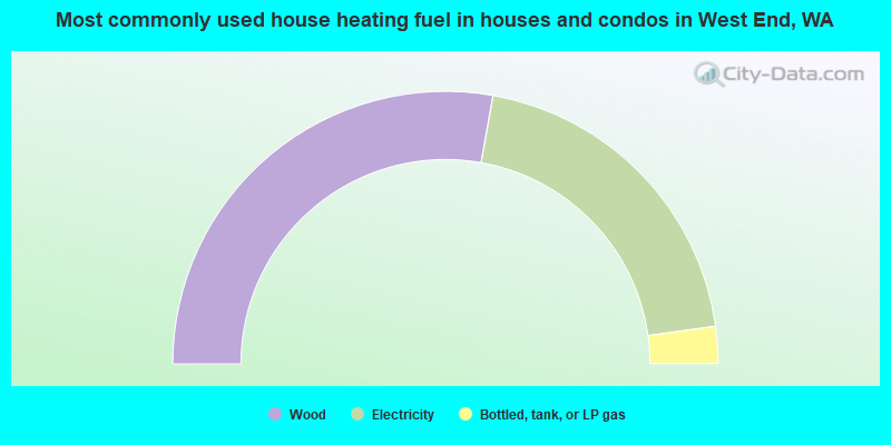
- 55.6%Wood
- 40.0%Electricity
- 4.4%Bottled, tank, or LP gas
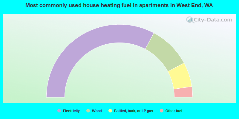
- 65.6%Electricity
- 18.8%Wood
- 10.9%Bottled, tank, or LP gas
- 4.7%Other fuel
West End compared to Washington state average:
- Median household income significantly below state average.
- Median house value below state average.
- Black race population percentage significantly below state average.
- Hispanic race population percentage below state average.
- Foreign-born population percentage significantly below state average.
- Length of stay since moving in significantly above state average.
- Number of rooms per house significantly below state average.
- House age significantly below state average.
- Institutionalized population percentage significantly above state average.
- Number of college students below state average.
- Percentage of population with a bachelor's degree or higher significantly below state average.
West End on our top lists:
- #88 on the list of "Top 100 cities with the largest percentage of males"
- #38 (98331) on the list of "Top 101 zip codes with the largest percentage of Swedish first ancestries (pop 5,000+)"