West Green, Georgia
Submit your own pictures of this place and show them to the world
- OSM Map
- General Map
- Google Map
- MSN Map

| Males: 1,438 | |
| Females: 1,390 |
| Median resident age: | 33.2 years |
| Georgia median age: | 33.4 years |
Zip code: 31533
| West Green: | $54,821 |
| GA: | $72,837 |
Estimated per capita income in 2022: $25,960 (it was $16,673 in 2000)
West Green CCD income, earnings, and wages data
Estimated median house or condo value in 2022: $143,396 (it was $48,200 in 2000)
| West Green: | $143,396 |
| GA: | $297,400 |
Mean prices in 2022: all housing units: $175,230; detached houses: $228,177; townhouses or other attached units: $234,523; mobile homes: $59,548
Detailed information about poverty and poor residents in West Green, GA


- 2,32088.1%White alone
- 1606.1%Black alone
- 1234.7%Hispanic
- 140.5%Asian alone
- 110.4%Two or more races
- 50.2%American Indian alone

Races in West Green detailed stats: ancestries, foreign born residents, place of birth
According to our research of Georgia and other state lists, there were 3 registered sex offenders living in West Green, Georgia as of May 26, 2024.
The ratio of all residents to sex offenders in West Green is 943 to 1.
The ratio of registered sex offenders to all residents in this city is lower than the state average.
 Recent articles from our blog. Our writers, many of them Ph.D. graduates or candidates, create easy-to-read articles on a wide variety of topics.
Current Local Time: EST time zone
Elevation: 254 feet
Land area: 100.0 square miles.
Population density: 28 people per square mile (very low).

| West Green CCD: | 1.1% ($543) |
| Georgia: | 0.9% ($919) |
Nearest city with pop. 50,000+: Albany, GA  (84.1 miles , pop. 76,939).
Nearest city with pop. 200,000+: Jacksonville, FL (109.1 miles , pop. 735,617).
Nearest city with pop. 1,000,000+: Philadelphia, PA (719.8 miles , pop. 1,517,550).
Nearest cities:
), ), ), ), )Latitude: 31.60 N, Longitude: 82.74 W
Area code commonly used in this area: 912


| Here: | 3.2% |
| Georgia: | 2.9% |

- Construction (10.6%)
- Agriculture, forestry, fishing & hunting (9.4%)
- Wood products (7.3%)
- Health care (6.6%)
- Department & other general merchandise stores (5.5%)
- Public administration (4.8%)
- Accommodation & food services (4.5%)

- Construction (16.6%)
- Agriculture, forestry, fishing & hunting (12.1%)
- Wood products (11.9%)
- Building material & garden equipment & supplies dealers (4.2%)
- Public administration (4.2%)
- Food (4.1%)
- Department & other general merchandise stores (3.9%)

- Health care (17.0%)
- Educational services (8.2%)
- Department & other general merchandise stores (7.9%)
- Public administration (5.7%)
- Accommodation & food services (5.7%)
- Agriculture, forestry, fishing & hunting (5.3%)
- Textile mills & textile products (5.3%)

- Other production occupations, including supervisors (6.0%)
- Electrical equipment mechanics and other installation, maintenance, and repair workers, including supervisors (5.8%)
- Other sales and related occupations, including supervisors (5.2%)
- Driver/sales workers and truck drivers (4.8%)
- Material recording, scheduling, dispatching, and distributing workers (4.3%)
- Vehicle and mobile equipment mechanics, installers, and repairers (3.8%)
- Agricultural workers, including supervisors (3.5%)

- Electrical equipment mechanics and other installation, maintenance, and repair workers, including supervisors (9.6%)
- Driver/sales workers and truck drivers (7.9%)
- Other production occupations, including supervisors (7.2%)
- Material recording, scheduling, dispatching, and distributing workers (5.6%)
- Other sales and related occupations, including supervisors (5.5%)
- Vehicle and mobile equipment mechanics, installers, and repairers (5.2%)
- Carpenters (4.6%)

- Registered nurses (6.4%)
- Cashiers (6.2%)
- Other sales and related occupations, including supervisors (4.9%)
- Assemblers and fabricators (4.6%)
- Textile, apparel, and furnishings workers (4.4%)
- Customer service representatives (4.4%)
- Other production occupations, including supervisors (4.2%)
Average climate in West Green, Georgia
Based on data reported by over 4,000 weather stations


(lower is better)

Lead (Pb) [µg/m3] level in 2018 was 0.00200. This is significantly better than average. Closest monitor was 5.9 miles away from the city center.
| City: | 0.00200 |
| U.S.: | 0.00931 |
Tornado activity:
West Green-area historical tornado activity is slightly below Georgia state average. It is 2% greater than the overall U.S. average.
On 4/8/1957, a category F3 (max. wind speeds 158-206 mph) tornado 18.2 miles away from the West Green place center killed one person and injured 3 people and caused between $5000 and $50,000 in damages.
On 5/11/1952, a category F3 tornado 30.5 miles away from the place center injured 10 people and caused between $500,000 and $5,000,000 in damages.
Earthquake activity:
West Green-area historical earthquake activity is significantly above Georgia state average. It is 34% smaller than the overall U.S. average.On 8/2/1974 at 08:52:09, a magnitude 4.9 (4.3 MB, 4.9 LG, Class: Light, Intensity: IV - V) earthquake occurred 157.9 miles away from West Green center
On 11/22/1974 at 05:25:55, a magnitude 4.7 (4.7 MB) earthquake occurred 176.4 miles away from West Green center
On 4/29/2003 at 08:59:39, a magnitude 4.9 (4.4 MB, 4.6 MW, 4.9 LG) earthquake occurred 261.2 miles away from the city center
On 10/24/1997 at 08:35:17, a magnitude 4.9 (4.8 MB, 4.2 MS, 4.9 LG, Depth: 6.2 mi) earthquake occurred 269.8 miles away from West Green center
On 8/21/1992 at 16:31:55, a magnitude 4.4 (4.1 MB, 4.1 LG, 4.4 LG, Depth: 6.2 mi) earthquake occurred 183.2 miles away from West Green center
On 2/15/2014 at 03:23:38, a magnitude 4.1 (4.1 MW, Depth: 3.2 mi) earthquake occurred 158.0 miles away from West Green center
Magnitude types: regional Lg-wave magnitude (LG), body-wave magnitude (MB), surface-wave magnitude (MS), moment magnitude (MW)
Natural disasters:
The number of natural disasters in Coffee County (12) is smaller than the US average (15).Major Disasters (Presidential) Declared: 6
Emergencies Declared: 4
Causes of natural disasters: Floods: 3, Hurricanes: 3, Storms: 3, Tornadoes: 3, Drought: 1, Fire: 1, Snowfall: 1, Tropical Storm: 1, Wind: 1, Winter Storm: 1, Other: 1 (Note: some incidents may be assigned to more than one category).
Hospitals and medical centers near West Green:
- FAIR HAVEN CONVALESCENT HOME (Nursing Home, about 9 miles away; DOUGLAS, GA)
- SHADY ACRES HEALTH AND REHABILITATION (Nursing Home, about 10 miles away; DOUGLAS, GA)
- DOUGLAS DIALYSIS (Dialysis Facility, about 10 miles away; DOUGLAS, GA)
- COFFEE REGIONAL MEDICAL CENTER Acute Care Hospitals (about 10 miles away; DOUGLAS, GA)
- HOSPICE OF COFFEE REGIONAL MC (Hospital, about 11 miles away; DOUGLAS, GA)
Colleges/universities with over 2000 students nearest to West Green:
- South Georgia State College (about 10 miles; Douglas, GA; Full-time enrollment: 2,507)
- Abraham Baldwin Agricultural College (about 48 miles; Tifton, GA; FT enrollment: 2,564)
- Wiregrass Georgia Technical College (about 62 miles; Valdosta, GA; FT enrollment: 3,246)
- Valdosta State University (about 62 miles; Valdosta, GA; FT enrollment: 11,155)
- East Georgia State College (about 74 miles; Swainsboro, GA; FT enrollment: 2,345)
- College of Coastal Georgia (about 81 miles; Brunswick, GA; FT enrollment: 2,447)
- Georgia Southern University (about 81 miles; Statesboro, GA; FT enrollment: 18,824)
Public elementary/middle school in West Green:
- WEST GREEN ELEMENTARY SCHOOL (Students: 375, Location: 106 SCHOOL CIRCLE RD, Grades: PK-5)
Points of interest:
Notable locations in West Green: Beaver Creek Golf Course (A), Coffee County Fire / Rescue Station 11West Green (B). Display/hide their locations on the map
Churches in West Green include: Parkview Church (A), Lone Hill Church (B), Mount Calvary Church (C), Oak Grove Church (D), Pickerton Church (E), Pineview Church (F), Providence Church (G), Shady Grove Church (H), Central Church (I). Display/hide their locations on the map
Cemeteries: Burkett Cemetery (1), Central Cemetery (2), Lone Hill Cemetery (3), Ward Cemetery (4), Wood-Spell Cemetery (5), Oak Grove Cemetery (6), Wilcox Cemetery (7). Display/hide their locations on the map
Reservoir: Higgs Lake (A). Display/hide its location on the map
Creeks: Broxton Creek (A), Ninemile Creek (B). Display/hide their locations on the map
Park in West Green: General Coffee State Park (1). Display/hide its location on the map
| This place: | 2.8 people |
| Georgia: | 2.6 people |
| This place: | 77.2% |
| Whole state: | 68.5% |
| This place: | 5.7% |
| Whole state: | 5.9% |
Likely homosexual households (counted as self-reported same-sex unmarried-partner households)
- Lesbian couples: 0.6% of all households
- Gay men: 0.7% of all households
| This place: | 12.3% |
| Whole state: | 13.0% |
| This place: | 6.5% |
| Whole state: | 6.1% |
For population 15 years and over in West Green:

- Never married: 19.7%
- Now married: 66.3%
- Separated: 1.1%
- Widowed: 7.3%
- Divorced: 6.7%
For population 25 years and over in West Green:
- High school or higher: 63.6%
- Bachelor's degree or higher: 10.8%
- Graduate or professional degree: 3.9%
- Unemployed: 6.7%
- Mean travel time to work (commute): 24.5 minutes


| Here: | 13.5 |
| Georgia average: | 13.3 |
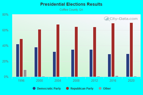
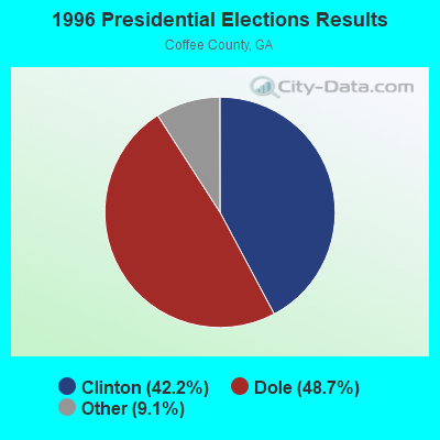
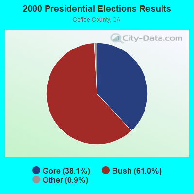


Graphs represent county-level data. Detailed 2008 Election Results
Religion statistics for West Green, GA (based on Coffee County data)
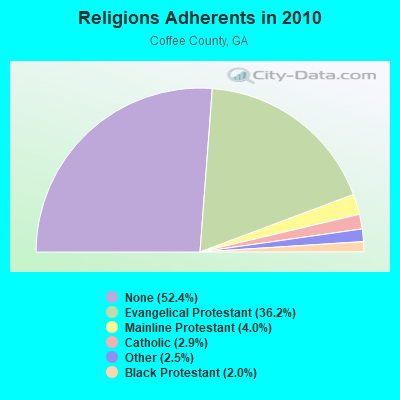
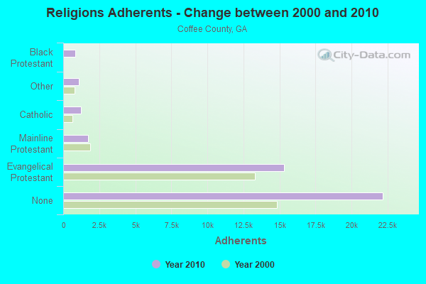
| Religion | Adherents | Congregations |
|---|---|---|
| Evangelical Protestant | 15,328 | 70 |
| Mainline Protestant | 1,702 | 11 |
| Catholic | 1,208 | 1 |
| Other | 1,075 | 3 |
| Black Protestant | 854 | 6 |
| None | 22,189 | - |
Food Environment Statistics:
| This county: | 1.49 / 10,000 pop. |
| State: | 1.91 / 10,000 pop. |
| Coffee County: | 0.25 / 10,000 pop. |
| State: | 0.15 / 10,000 pop. |
| Coffee County: | 1.74 / 10,000 pop. |
| Georgia: | 0.86 / 10,000 pop. |
| This county: | 9.96 / 10,000 pop. |
| Georgia: | 5.12 / 10,000 pop. |
| Coffee County: | 4.48 / 10,000 pop. |
| Georgia: | 7.41 / 10,000 pop. |
| This county: | 12.2% |
| Georgia: | 10.4% |
| Here: | 31.1% |
| Georgia: | 27.8% |
| This county: | 19.6% |
| Georgia: | 14.6% |
Strongest AM radio stations in West Green:
- WDMG (860 AM; 5 kW; DOUGLAS, GA; Owner: RTG RADIO, LLC)
- WOKA (1310 AM; 4 kW; DOUGLAS, GA; Owner: COFFEE COUNTY BROADCASTERS, INC.)
- WUFE (1260 AM; daytime; 5 kW; BAXLEY, GA; Owner: SOUTH GEORGIA BROADCASTERS, INC.)
- WOKV (690 AM; 50 kW; JACKSONVILLE, FL; Owner: COX RADIO, INC.)
- WFVR (910 AM; 50 kW; VALDOSTA, GA; Owner: RAMA COMMUNICATIONS, INC.)
- WMAC (940 AM; 50 kW; MACON, GA; Owner: CUMULUS LICENSING CORP.)
- WOBS (1530 AM; daytime; 50 kW; JACKSONVILLE, FL; Owner: WORD BROADCASTING NETWORK, INC.)
- WSTT (730 AM; 25 kW; THOMASVILLE, GA; Owner: MARION R. WILLIAMS)
- WAJQ (1400 AM; 1 kW; ALMA, GA; Owner: BLUEBERRY BROADCASTING COMPANY, INC.)
- WGSR (1570 AM; 50 kW; FERNANDINA BEACH, FL; Owner: RJM COMMUNICATIONS, INC)
- WVOP (970 AM; 5 kW; VIDALIA, GA; Owner: VIDALIA COMMUNICATIONS CORPORATION)
- WGST (640 AM; 50 kW; ATLANTA, GA; Owner: CITICASTERS LICENSES, L.P.)
- WCNN (680 AM; 50 kW; NORTH ATLANTA, GA; Owner: DICKEY BROADCASTING COMPANY)
Strongest FM radio stations in West Green:
- WOKA-FM (106.7 FM; DOUGLAS, GA; Owner: COFFEE COUNTY BROADCASTERS, INC.)
- WBYZ (94.5 FM; BAXLEY, GA; Owner: SOUTH GEORGIA BROADCASTERS, INC.)
- WULS (103.7 FM; BROXTON, GA; Owner: ROUNDTREE-CARVER ENTERPRISES, INC)
- WXVS (90.1 FM; WAYCROSS, GA; Owner: GEORGIA PUBLIC TELECOMMUNICATIONS COMMISSION)
- WAJQ-FM (104.3 FM; ALMA, GA; Owner: BLUEBERRY BROADCASTING COMPANY, INC.)
- WPNG (101.9 FM; PEARSON, GA; Owner: KM RADIO OF PEARSON, L.L.C.)
- WVOH-FM (93.5 FM; HAZLEHURST, GA; Owner: JEFF DAVIS BROADCASTERS, INC.)
- WLPF (98.5 FM; OCILLA, GA; Owner: BARINOWSKI INVESTMENT COMPANY)
TV broadcast stations around West Green:
- WXGA-TV (Channel 8; WAYCROSS, GA; Owner: GEORGIA PUBLIC TELECOMMUNICATIONS COMMISSION)
- WPXC-TV (Channel 21; BRUNSWICK, GA; Owner: PAXSON JAX LICENSE, INC.)
- W12DA (Channel 12; TIFTON, GA; Owner: TIFT AREA TV, INC.)
- W56DU (Channel 56; HAZLEHURST, GA; Owner: JEFF DAVIS BROADCASTERS, INC.)

West Green fatal accident list:
Nov 11, 2010 05:47 PM, New Forest Hwy, Lat: 31.528572, Lon: -82.806947, Vehicles: 1, Persons: 1, Fatalities: 1, Drunk persons involved: 1
FCC Registered Antenna Towers:
11 (See the full list of FCC Registered Antenna Towers in West Green)FCC Registered Broadcast Land Mobile Towers:
1- Lat: 31.642139 Lon: -82.684000, Call Sign: WQSD507,
Assigned Frequencies: 159.915 MHz, Grant Date: 09/04/2013, Expiration Date: 09/04/2023, Cancellation Date: 11/04/2023, Certifier: Keith Burkett, Registrant: Washington Radio Reports, 1588 Fairfield Road Ste 7, Gettysburg, PA 17325, Phone: (717) 334-0668, Fax: (717) 334-6440, Email:
FCC Registered Amateur Radio Licenses:
4- Call Sign: KE4QOQ, Licensee ID: L00910213, Grant Date: 08/25/2004, Expiration Date: 09/14/2014, Cancellation Date: 09/15/2016, Certifier: Paul D Taft Sr, Registrant: Paul D Taft Sr, 999 Nicholls Road, West Green, GA 31567
- Call Sign: WB4ZUO, Licensee ID: L00868973, Grant Date: 05/26/2004, Expiration Date: 08/23/2014, Cancellation Date: 08/24/2016, Certifier: Jesse W Taft Sr, Registrant: Jesse W Taft Sr, 999 Nichels Rd, West Green, GA 31567
- Call Sign: KG4RJA, Licensee ID: L00461052, Grant Date: 02/04/2002, Expiration Date: 02/04/2012, Cancellation Date: 02/05/2014, Certifier: Henry R Herrin, Registrant: Henry R Herrin, 80 Cedar Ridge Rd, West Green, GA 31567
- Call Sign: KO4ULN, Licensee ID: L02499166, Grant Date: 11/04/2021, Expiration Date: 11/04/2031, Certifier: Charles W Davis Ii, Registrant: Charles W Davis Ii, 1192 Nicholls Rd, West Green, GA 31567-4246
2003 - 2018 National Fire Incident Reporting System (NFIRS) incidents
- Fire incident types reported to NFIRS in West Green, GA
- 7967.5%Outside Fires
- 2420.5%Structure Fires
- 1412.0%Mobile Property/Vehicle Fires
 According to the data from the years 2003 - 2018 the average number of fire incidents per year is 7. The highest number of reported fires - 22 took place in 2011, and the least - 0 in 2004. The data has an increasing trend.
 When looking into fire subcategories, the most reports belonged to: Outside Fires (67.5%), and Structure Fires (20.5%).
- 75.9%Electricity
- 17.2%Bottled, tank, or LP gas
- 3.3%Utility gas
- 2.0%Wood
- 1.0%Other fuel
- 0.7%No fuel used

- 59.4%Electricity
- 40.6%Bottled, tank, or LP gas
West Green compared to Georgia state average:
- Median house value below state average.
- Unemployed percentage below state average.
- Black race population percentage significantly below state average.
- Hispanic race population percentage below state average.
- Median age below state average.
- Foreign-born population percentage significantly below state average.
- Renting percentage below state average.
- Length of stay since moving in significantly above state average.
- Number of rooms per house significantly below state average.
- House age significantly below state average.
- Percentage of population with a bachelor's degree or higher below state average.