West Johnston, Oklahoma
Submit your own pictures of this place and show them to the world
- OSM Map
- General Map
- Google Map
- MSN Map

| Males: 1,315 | |
| Females: 1,372 |
| Median resident age: | 37.3 years |
| Oklahoma median age: | 35.5 years |
Zip code: 74856
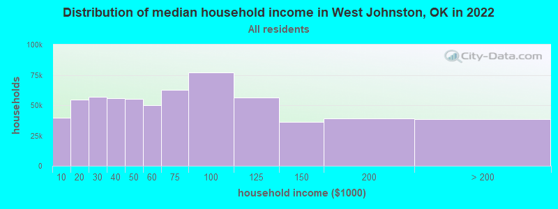
| West Johnston: | $50,642 |
| OK: | $59,673 |
Estimated per capita income in 2022: $22,131 (it was $12,704 in 2000)
West Johnston CCD income, earnings, and wages data
Estimated median house or condo value in 2022: $97,176 (it was $38,200 in 2000)
| West Johnston: | $97,176 |
| OK: | $191,700 |
Detailed information about poverty and poor residents in West Johnston, OK


- 2,10878.0%White alone
- 38014.1%American Indian alone
- 1836.8%Two or more races
- 190.7%Hispanic
- 60.2%Asian alone
- 40.1%Native Hawaiian and Other
Pacific Islander alone - 10.04%Black alone
- 10.04%Other race alone

Races in West Johnston detailed stats: ancestries, foreign born residents, place of birth
 Recent articles from our blog. Our writers, many of them Ph.D. graduates or candidates, create easy-to-read articles on a wide variety of topics.
Current Local Time: CST time zone
Land area: 181.4 square miles.
Population density: 15 people per square mile (very low).

| West Johnston CCD: | 0.5% ($199) |
| Oklahoma: | 0.8% ($523) |
Nearest city with pop. 50,000+: East Grayson, TX (47.7 miles  , pop. 81,381).
Nearest city with pop. 200,000+: Plano, TX (85.8 miles , pop. 222,030).
Nearest city with pop. 1,000,000+: Dallas, TX (103.1 miles , pop. 1,188,580).
Nearest cities:
), ), ), ), Latitude: 34.29 N, Longitude: 96.81 W
Area code commonly used in this area: 580

| Here: | 3.9% |
| Oklahoma: | 3.2% |

- Educational services (9.5%)
- Health care (8.7%)
- Construction (7.5%)
- Plastics & rubber products (6.8%)
- Transportation equipment (5.9%)
- Accommodation & food services (5.3%)
- Public administration (4.6%)

- Construction (11.9%)
- Plastics & rubber products (9.7%)
- Transportation equipment (8.8%)
- Truck transportation (6.6%)
- Agriculture, forestry, fishing & hunting (6.4%)
- Mining, quarrying, oil & gas extraction (6.0%)
- Metal & metal products (4.9%)

- Health care (18.9%)
- Educational services (17.1%)
- Accommodation & food services (9.2%)
- Public administration (8.1%)
- Department & other general merchandise stores (7.0%)
- Finance & insurance (3.6%)
- Food (3.4%)

- Other production occupations, including supervisors (6.7%)
- Driver/sales workers and truck drivers (6.4%)
- Metal workers and plastic workers (5.4%)
- Electrical equipment mechanics and other installation, maintenance, and repair workers, including supervisors (3.7%)
- Preschool, kindergarten, elementary, and middle school teachers (3.6%)
- Material recording, scheduling, dispatching, and distributing workers (3.5%)
- Building and grounds cleaning and maintenance occupations (3.4%)

- Driver/sales workers and truck drivers (10.8%)
- Metal workers and plastic workers (9.1%)
- Other production occupations, including supervisors (8.9%)
- Electrical equipment mechanics and other installation, maintenance, and repair workers, including supervisors (5.8%)
- Other material moving workers, except laborers (4.2%)
- Laborers and material movers, hand (3.9%)
- Agricultural workers, including supervisors (3.6%)

- Preschool, kindergarten, elementary, and middle school teachers (7.9%)
- Secretaries and administrative assistants (7.2%)
- Nursing, psychiatric, and home health aides (5.8%)
- Building and grounds cleaning and maintenance occupations (4.7%)
- Material recording, scheduling, dispatching, and distributing workers (4.7%)
- Information and record clerks, except customer service representatives (4.3%)
- Other teachers, instructors, education, training, and library occupations (4.0%)
Average climate in West Johnston, Oklahoma
Based on data reported by over 4,000 weather stations


Tornado activity:
West Johnston-area historical tornado activity is near Oklahoma state average. It is 160% greater than the overall U.S. average.
On 4/27/1966, a category F4 (max. wind speeds 207-260 mph) tornado 15.9 miles away from the West Johnston place center injured 2 people and caused between $50,000 and $500,000 in damages.
On 4/2/1957, a category F4 tornado 21.0 miles away from the place center killed 2 people and injured 6 people and caused between $500,000 and $5,000,000 in damages.
Earthquake activity:
West Johnston-area historical earthquake activity is significantly above Oklahoma state average. It is 660% greater than the overall U.S. average.On 11/6/2011 at 03:53:10, a magnitude 5.7 (5.7 MW, Depth: 3.2 mi, Class: Moderate, Intensity: VI - VII) earthquake occurred 85.9 miles away from West Johnston center
On 9/3/2016 at 12:02:44, a magnitude 5.8 (5.8 MW, Depth: 3.5 mi) earthquake occurred 147.8 miles away from West Johnston center
On 11/7/2016 at 01:44:24, a magnitude 5.0 (5.0 MW, Depth: 2.8 mi) earthquake occurred 117.6 miles away from West Johnston center
On 11/8/2011 at 02:46:57, a magnitude 4.8 (4.8 MW, Depth: 3.1 mi, Class: Light, Intensity: IV - V) earthquake occurred 85.8 miles away from the city center
On 11/5/2011 at 07:12:45, a magnitude 4.8 (4.8 MW, Depth: 1.9 mi) earthquake occurred 87.2 miles away from the city center
On 9/6/1997 at 23:38:00, a magnitude 4.5 (4.5 LG, 4.2 LG, Depth: 3.1 mi) earthquake occurred 33.2 miles away from West Johnston center
Magnitude types: regional Lg-wave magnitude (LG), moment magnitude (MW)
Natural disasters:
The number of natural disasters in Johnston County (16) is near the US average (15).Major Disasters (Presidential) Declared: 8
Emergencies Declared: 6
Causes of natural disasters: Storms: 8, Floods: 7, Winter Storms: 6, Tornadoes: 5, Winds: 2, Hurricane: 1, Snow: 1, Other: 1 (Note: some incidents may be assigned to more than one category).
Hospitals and medical centers near West Johnston:
- SISTERLY CARE HEALTH SERVICES L L C (Home Health Center, about 8 miles away; TISHOMINGO, OK)
- VICTORY HOME HEALTH AND HOSPICE (Home Health Center, about 9 miles away; TISHOMINGO, OK)
- LAWNVIEW NURSING CTR (Nursing Home, about 9 miles away; TISHOMINGO, OK)
- MERCY HOSPITAL TISHOMINGO INC Critical Access Hospitals (about 9 miles away; TISHOMINGO, OK)
- INDIAN TERRITORY HOME HEALTH AND HOSPICE I, LLC (Home Health Center, about 9 miles away; TISHOMINGO, OK)
- HILLCREST HEALTHCARE (Nursing Home, about 9 miles away; TISHOMINGO, OK)
- HILLCREST NH (Nursing Home, about 10 miles away; TISHOMINGO, OK)
Colleges/universities with over 2000 students nearest to West Johnston:
- Southeastern Oklahoma State University (about 32 miles; Durant, OK; Full-time enrollment: 3,365)
- East Central University (about 35 miles; Ada, OK; FT enrollment: 4,030)
- Grayson College (about 42 miles; Denison, TX; FT enrollment: 2,496)
- North Central Texas College (about 51 miles; Gainesville, TX; FT enrollment: 6,550)
- University of Oklahoma-Norman Campus (about 74 miles; Norman, OK; FT enrollment: 22,496)
- Texas Woman's University (about 76 miles; Denton, TX; FT enrollment: 11,837)
- University of North Texas (about 78 miles; Denton, TX; FT enrollment: 31,694)
Points of interest:
Notable locations in West Johnston: House (A), Randolph (B), Mill Creek Fire Department (C), Ravia Volunteer Fire Department (D), Mannsville Volunteer Fire Department Station 2 (E). Display/hide their locations on the map
Church in West Johnston: Russett Church (A). Display/hide its location on the map
Cemeteries: Troy Cemetery (1), Ravia Cemetery (2), Mannsville Cemetery (3), Alberson & Lewis Cemetery (4), Lone Cedar Cemetery (5), Mill Creek Cemetery (6), Russett Cemetery (7). Display/hide their locations on the map
Lakes and reservoirs: Randolph Lake (A), Pennington Creek Site 2 Reservoir (B), Mill Creek Watershed Site 11 Reservoir (C), Mill Creek Watershed Site 12 Reservoir (D), Mill Creek Watershed Site 15 Reservoir (E), Mill Creek Watershed Site 17 Reservoir (F), Mill Creek Watershed Site 18 Reservoir (G), Oknoname 069002 Reservoir (H). Display/hide their locations on the map
Streams, rivers, and creeks: Courtney Creek (A), Turkey Creek (B), Bee Branch (C), Threemile Creek (D), Sycamore Creek (E), Sand Creek (F), Sixmile Creek (G), Wolf Creek (H), Camp Creek (I). Display/hide their locations on the map
| This place: | 2.6 people |
| Oklahoma: | 2.5 people |
| This place: | 71.8% |
| Whole state: | 66.8% |
| This place: | 7.0% |
| Whole state: | 5.9% |
Likely homosexual households (counted as self-reported same-sex unmarried-partner households)
- Lesbian couples: 0.4% of all households
- Gay men: 0.2% of all households
| This place: | 20.1% |
| Whole state: | 14.7% |
| This place: | 7.9% |
| Whole state: | 6.1% |
For population 15 years and over in West Johnston:

- Never married: 15.3%
- Now married: 63.6%
- Separated: 1.5%
- Widowed: 9.4%
- Divorced: 11.7%
For population 25 years and over in West Johnston:
- High school or higher: 69.9%
- Bachelor's degree or higher: 8.8%
- Graduate or professional degree: 2.4%
- Unemployed: 5.2%
- Mean travel time to work (commute): 24.7 minutes


| Here: | 10.5 |
| Oklahoma average: | 11.7 |
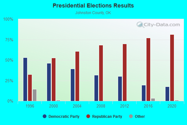
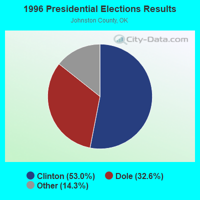
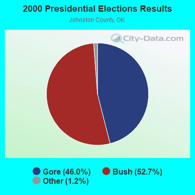
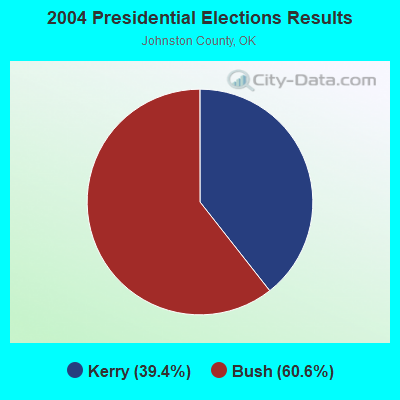
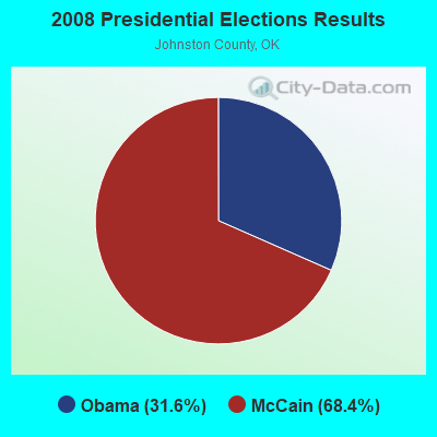
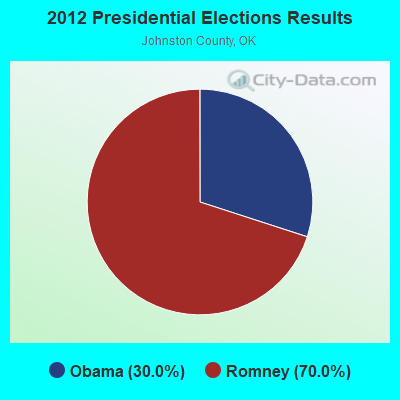
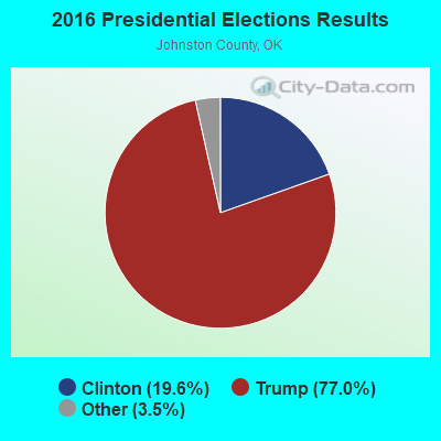
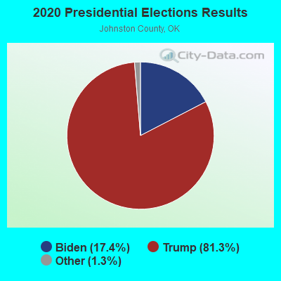
Graphs represent county-level data. Detailed 2008 Election Results
Religion statistics for West Johnston, OK (based on Johnston County data)
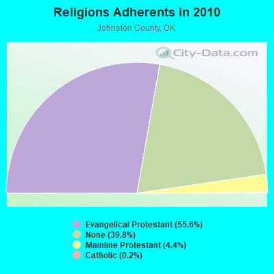
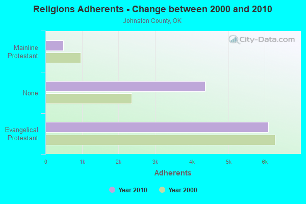
| Religion | Adherents | Congregations |
|---|---|---|
| Evangelical Protestant | 6,093 | 36 |
| Mainline Protestant | 484 | 5 |
| Catholic | 20 | 1 |
| Other | 2 | 1 |
| None | 4,358 | - |
Food Environment Statistics:
| This county: | 1.92 / 10,000 pop. |
| Oklahoma: | 1.97 / 10,000 pop. |
| Johnston County: | 0.96 / 10,000 pop. |
| Oklahoma: | 0.76 / 10,000 pop. |
| This county: | 12.50 / 10,000 pop. |
| State: | 4.35 / 10,000 pop. |
| This county: | 4.81 / 10,000 pop. |
| Oklahoma: | 6.89 / 10,000 pop. |
| Johnston County: | 11.1% |
| State: | 10.3% |
| This county: | 31.0% |
| Oklahoma: | 29.2% |
Strongest AM radio stations in West Johnston:
- KYNG (950 AM; 10 kW; DENISON-SHERMAN, TX; Owner: KRBE LICO, INC.)
- KOMA (1520 AM; 50 kW; OKLAHOMA CITY, OK; Owner: RENDA BROADCASTING CORP. OF NEVADA)
- KRLD (1080 AM; 50 kW; DALLAS, TX; Owner: TEXAS INFINITY BROADCASTING L.P.)
- KFXR (1190 AM; 50 kW; DALLAS, TX; Owner: CLEAR CHANNEL BROADCASTING LICENSES, INC.)
- WBAP (820 AM; 50 kW; FORT WORTH, TX; Owner: WBAP-KSCS OPERATING, LTD.)
- KRMG (740 AM; 50 kW; TULSA, OK; Owner: CXR HOLDINGS, INC.)
- KEOR (1110 AM; daytime; 5 kW; ATOKA, OK; Owner: DALLAS AM RADIO PARTNERS, L.P.)
- KESS (1270 AM; 50 kW; FORT WORTH, TX; Owner: KESS-AM LICENSE CORP.)
- KZMP (1540 AM; 50 kW; UNIVERSITY PARK, TX; Owner: ENTRAVISION HOLDINGS, LLC)
- KTBK (1700 AM; 10 kW; SHERMAN, TX; Owner: KRBE LICO, INC.)
- KAHZ (1360 AM; 50 kW; HURST, TX)
- KSKY (660 AM; 20 kW; BALCH SPRINGS, TX; Owner: BISON MEDIA, INC.)
- KBIS (1150 AM; 25 kW; HIGHLAND PARK, TX; Owner: DALLAS AM RADIO PARTNERS, L.P.)
Strongest FM radio stations in West Johnston:
- KAZC (88.3 FM; TISHOMINGO, OK; Owner: SOUTH CENTRAL OKLAHOMA CHRISTIAN BROADCASTING, INC.)
- KMAD-FM (102.5 FM; WHITESBORO, TX; Owner: NM LICENSING, LLC)
- KTCY (104.9 FM; PILOT POINT, TX; Owner: ENTRAVISION HOLDINGS, LLC)
- KACO (98.5 FM; ARDMORE, OK; Owner: A.M. & P.M. COMMUNICATIONS, L.L.C.)
- KESN (103.3 FM; ALLEN, TX; Owner: WBAP-KSCS OPERATING, LTD.)
- KSOC (94.5 FM; GAINESVILLE, TX; Owner: RADIO ONE LICENSES, LLC)
- KTPW (89.7 FM; SANGER, TX; Owner: RESEARCH EDUCATIONAL FOUNDATION, INC)
- KTRX (92.7 FM; DICKSON, OK; Owner: NM LICENSING, LLC)
- KIXO (106.1 FM; SULPHUR, OK; Owner: DFWU, INC.)
- KESS-FM (107.9 FM; LEWISVILLE, TX; Owner: KECS-FM LICENSE CORPORATION)
- KLBC (106.3 FM; DURANT, OK; Owner: TEXOMA BROADCASTING, INC.)
- KKAJ-FM (95.7 FM; ARDMORE, OK; Owner: NM LICENSING, LLC)
- KFXT (90.7 FM; SULPHUR, OK; Owner: SISTER SHERRY LYNN FOUNDATION, INC.)
- KYNZ (107.1 FM; LONE GROVE, OK; Owner: CHUCKIE BROADCASTING COMPANY)
TV broadcast stations around West Johnston:
- KTEN (Channel 10; ADA, OK; Owner: CHANNEL 49 ACQUISITION CORPORATION)
- KXII (Channel 12; SHERMAN, TX; Owner: KXII LICENSEE CORP.)
- K32EK (Channel 32; ARDMORE, OK; Owner: LOCKE SUPPLY COMPANY)
- KOKT-LP (Channel 20; SULPHUR, OK; Owner: EQUITY BROADCASTING CORPORATION)
- K44BQ (Channel 44; ARDMORE, OK; Owner: TRINITY BROADCASTING NETWORK)

- 36.4%Electricity
- 32.1%Utility gas
- 23.5%Bottled, tank, or LP gas
- 7.7%Wood
- 0.4%Other fuel

- 33.0%Utility gas
- 31.7%Bottled, tank, or LP gas
- 30.7%Electricity
- 3.7%Wood
- 0.9%No fuel used
West Johnston compared to Oklahoma state average:
- Median house value below state average.
- Unemployed percentage below state average.
- Black race population percentage significantly below state average.
- Hispanic race population percentage significantly below state average.
- Foreign-born population percentage significantly below state average.
- Length of stay since moving in significantly above state average.
- Number of rooms per house significantly below state average.
- House age significantly below state average.
- Percentage of population with a bachelor's degree or higher below state average.