West Salmon Falls, Idaho
Submit your own pictures of this place and show them to the world
- OSM Map
- General Map
- Google Map
- MSN Map

| Males: 292 | |
| Females: 188 |
| Median resident age: | 36.2 years |
| Idaho median age: | 33.2 years |
Zip code: 83321
| West Salmon Falls: | $71,377 |
| ID: | $72,785 |
Estimated per capita income in 2022: $29,212 (it was $15,550 in 2000)
West Salmon Falls CCD income, earnings, and wages data
Estimated median house or condo value in 2022: $321,148 (it was $87,500 in 2000)
| West Salmon Falls: | $321,148 |
| ID: | $432,500 |
West Salmon Falls, ID residents, houses, and apartments details
Detailed information about poverty and poor residents in West Salmon Falls, ID


- 29870.3%White alone
- 12128.5%Hispanic
- 30.7%Two or more races
- 20.5%Asian alone

Races in West Salmon Falls detailed stats: ancestries, foreign born residents, place of birth
 Recent articles from our blog. Our writers, many of them Ph.D. graduates or candidates, create easy-to-read articles on a wide variety of topics.
Current Local Time: MST time zone
Land area: 660.4 square miles.
Population density: 0.7 people per square mile (very low).

| West Salmon Falls CCD: | 1.2% ($1,091) |
| Idaho: | 1.0% ($1,007) |
Nearest city with pop. 50,000+: Boise, ID  (102.9 miles , pop. 185,787).
Nearest city with pop. 200,000+: Northwest Clackamas, OR (432.4 miles , pop. 224,220).
Nearest city with pop. 1,000,000+: Los Angeles, CA (608.3 miles , pop. 3,694,820).
Nearest cities:
Latitude: 42.46 N, Longitude: 114.95 W
Area code commonly used in this area: 208


| Here: | 3.2% |
| Idaho: | 3.1% |

- Agriculture, forestry, fishing & hunting (42.9%)
- Food (8.5%)
- Educational services (8.0%)
- Mining, quarrying, oil & gas extraction (6.2%)
- Metal & metal products (4.5%)
- Health care (4.0%)
- Machinery (2.7%)

- Agriculture, forestry, fishing & hunting (50.6%)
- Food (8.7%)
- Mining, quarrying, oil & gas extraction (8.1%)
- Metal & metal products (5.8%)
- Furniture & related product manufacturing (3.5%)
- Machinery (3.5%)
- Health care (3.5%)

- Educational services (34.6%)
- Agriculture, forestry, fishing & hunting (17.3%)
- Motor vehicle & parts dealers (7.7%)
- Food (7.7%)
- Finance & insurance (7.7%)
- Health care (5.8%)
- Arts, entertainment, recreation (5.8%)

- Agricultural workers, including supervisors (25.4%)
- Farmers and farm managers (12.9%)
- Other production occupations, including supervisors (9.4%)
- Extraction workers (6.2%)
- Assemblers and fabricators (6.2%)
- Preschool, kindergarten, elementary, and middle school teachers (4.0%)
- Building and grounds cleaning and maintenance occupations (2.7%)

- Agricultural workers, including supervisors (31.4%)
- Farmers and farm managers (16.9%)
- Other production occupations, including supervisors (12.2%)
- Extraction workers (8.1%)
- Assemblers and fabricators (8.1%)
- Metal workers and plastic workers (3.5%)
- Woodworkers (2.9%)

- Preschool, kindergarten, elementary, and middle school teachers (17.3%)
- Bookkeeping, accounting, and auditing clerks (9.6%)
- Life, physical, and social science technicians (7.7%)
- Other teachers, instructors, education, training, and library occupations (7.7%)
- Cashiers (7.7%)
- Secretaries and administrative assistants (7.7%)
- Cooks and food preparation workers (5.8%)
Average climate in West Salmon Falls, Idaho
Based on data reported by over 4,000 weather stations


(lower is better)

Air Quality Index (AQI) level in 2022 was 60.3. This is better than average.
| City: | 60.3 |
| U.S.: | 72.6 |

Particulate Matter (PM2.5) [µg/m3] level in 2022 was 6.73. This is better than average. Closest monitor was 22.1 miles away from the city center.
| City: | 6.73 |
| U.S.: | 8.11 |
Earthquake activity:
West Salmon Falls-area historical earthquake activity is significantly above Idaho state average. It is 2396% greater than the overall U.S. average.On 10/3/1915 at 06:52:48, a magnitude 7.6 (7.6 UK, Class: Major, Intensity: VIII - XII) earthquake occurred 189.4 miles away from West Salmon Falls center
On 10/28/1983 at 14:06:06, a magnitude 7.3 (6.2 MB, 7.3 MS, 7.0 MW) earthquake occurred 125.8 miles away from West Salmon Falls center, causing 2 deaths (2 shaking deaths) and 3 injuries, causing $15,000,000 total damage
On 8/18/1959 at 06:37:13, a magnitude 7.7 (7.7 UK) earthquake occurred 260.0 miles away from the city center, causing $26,000,000 total damage
On 3/31/2020 at 23:52:30, a magnitude 6.5 (6.5 MW, Depth: 7.5 mi, Class: Strong, Intensity: VII - IX) earthquake occurred 138.8 miles away from the city center
On 12/16/1954 at 11:07:12, a magnitude 7.0 (7.0 UK) earthquake occurred 276.3 miles away from the city center
On 12/21/1932 at 06:10:09, a magnitude 7.2 (7.2 UK) earthquake occurred 319.1 miles away from the city center
Magnitude types: body-wave magnitude (MB), surface-wave magnitude (MS), moment magnitude (MW)
Natural disasters:
The number of natural disasters in Twin Falls County (3) is a lot smaller than the US average (15).Emergencies Declared: 1
Causes of natural disasters: Flood: 1, Hurricane: 1, Winter Storm: 1, Other: 1 (Note: some incidents may be assigned to more than one category).
Colleges/universities with over 2000 students nearest to West Salmon Falls:
- College of Southern Idaho (about 26 miles; Twin Falls, ID; Full-time enrollment: 5,051)
- Boise State University (about 102 miles; Boise, ID; FT enrollment: 16,774)
- Northwest Nazarene University (about 112 miles; Nampa, ID; FT enrollment: 2,290)
- College of Western Idaho (about 113 miles; Nampa, ID; FT enrollment: 6,300)
- Idaho State University (about 132 miles; Pocatello, ID; FT enrollment: 10,350)
- Treasure Valley Community College (about 149 miles; Ontario, OR; FT enrollment: 2,055)
- Utah State University (about 169 miles; Logan, UT; FT enrollment: 21,131)
Points of interest:
Notable locations in West Salmon Falls: Guy Kinyon Cabin (A), Antelope Spring Ranch (B), Owsley Bridge Access Area (C), Rutherford Cabin (D), Steel Place (E), Conover Ranch (F), Clark Ranch (G), China Creek Ranch (H), Mahannah Cabin (I), Lone Pine (J), House Creek Ranch (K), Guerry Corral (L), Devil Creek Ranch (M). Display/hide their locations on the map
Lakes and reservoirs: Dry Pond (A), Johns Pond (B), Merles Pond (C), Twin Lakes (D), Cedar Mesa Reservoir (E), Cedar Creek Reservoir (F), Worley Reservoir (G), Upper Salmon Falls Reservoir (H). Display/hide their locations on the map
Streams, rivers, and creeks: Barbour Creek (A), Browns Creek (B), China Creek (C), Corral Creek (D), Devil Creek (E), House Creek (F), Player Creek (G), Whiskey Slough (H), Yahoo Creek (I). Display/hide their locations on the map
Parks in West Salmon Falls include: Balanced Rock State Park (1), Balanced Rock County Park (2), Hagerman Fossil Beds National Monument (3). Display/hide their locations on the map
| This place: | 2.5 people |
| Idaho: | 2.7 people |
| This place: | 65.3% |
| Whole state: | 69.6% |
| This place: | 5.6% |
| Whole state: | 6.3% |
No gay or lesbian households reported
| This place: | 12.6% |
| Whole state: | 11.8% |
| This place: | 3.2% |
| Whole state: | 4.6% |
For population 15 years and over in West Salmon Falls:

- Never married: 10.7%
- Now married: 83.6%
- Separated: 0.3%
- Widowed: 1.5%
- Divorced: 4.2%
For population 25 years and over in West Salmon Falls:
- High school or higher: 82.7%
- Bachelor's degree or higher: 13.7%
- Graduate or professional degree: 6.2%
- Unemployed: 6.3%
- Mean travel time to work (commute): 19.8 minutes


| Here: | 10.7 |
| Idaho average: | 11.1 |
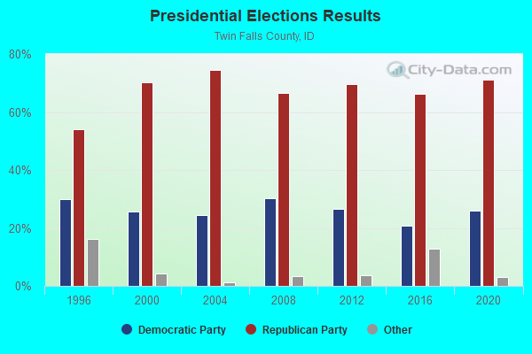
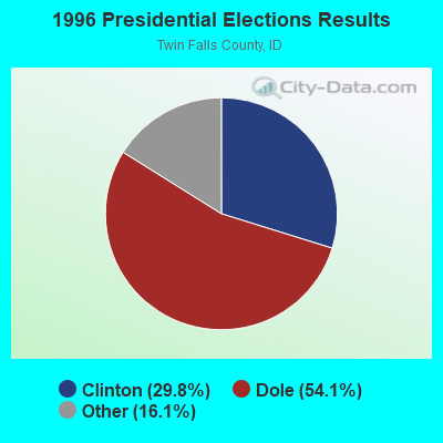
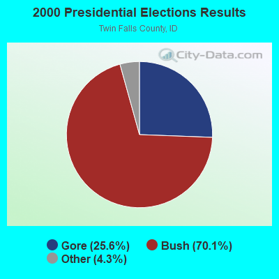
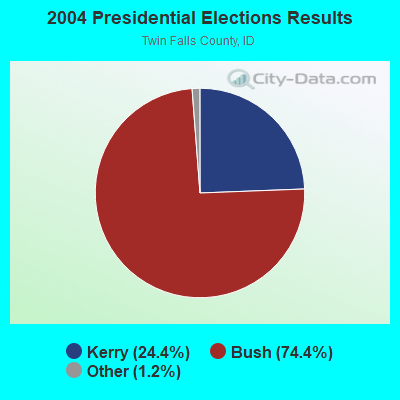
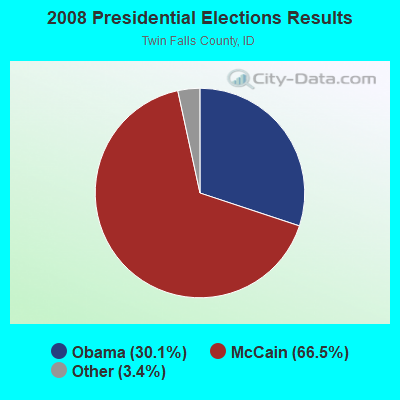
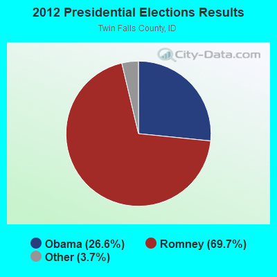
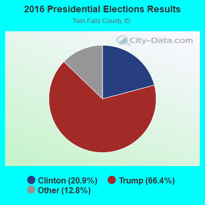
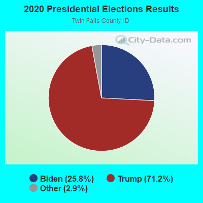
Graphs represent county-level data. Detailed 2008 Election Results
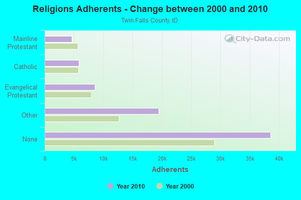
Religion statistics for West Salmon Falls, ID (based on Twin Falls County data)
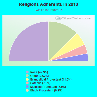
| Religion | Adherents | Congregations |
|---|---|---|
| Other | 19,451 | 51 |
| Evangelical Protestant | 8,520 | 55 |
| Catholic | 5,826 | 2 |
| Mainline Protestant | 4,632 | 18 |
| Black Protestant | 179 | 1 |
| Orthodox | 51 | 1 |
| None | 38,571 | - |
Food Environment Statistics:
| Twin Falls County: | 2.75 / 10,000 pop. |
| Idaho: | 1.88 / 10,000 pop. |
| Here: | 0.27 / 10,000 pop. |
| Idaho: | 0.28 / 10,000 pop. |
| Twin Falls County: | 0.41 / 10,000 pop. |
| Idaho: | 0.53 / 10,000 pop. |
| Twin Falls County: | 4.80 / 10,000 pop. |
| Idaho: | 3.87 / 10,000 pop. |
| Here: | 7.14 / 10,000 pop. |
| Idaho: | 7.75 / 10,000 pop. |
| Twin Falls County: | 8.5% |
| Idaho: | 7.7% |
| This county: | 27.2% |
| State: | 25.7% |
| Twin Falls County: | 11.4% |
| State: | 11.7% |
Strongest AM radio stations in West Salmon Falls:
- KTFI (1270 AM; 5 kW; TWIN FALLS, ID; Owner: AGM-IDAHO BROADCASTING, LLC)
- KBOI (670 AM; 50 kW; BOISE, ID; Owner: CITADEL BROADCASTING COMPANY)
- KLIX (1310 AM; 5 kW; TWIN FALLS, ID; Owner: CITICASTERS LICENSES, L.P.)
- KRXR (1480 AM; 5 kW; GOODING, ID; Owner: MARIA ELENA JUAREZ)
- KBSU (730 AM; 15 kW; BOISE, ID; Owner: IDAHO STATE BOARD OF EDUCATION)
- KALL (700 AM; 50 kW; NORTH SALT LAKE CITY, UT; Owner: CITICASTERS LICENSES, L.P.)
- KWEI (1260 AM; 50 kW; WEISER, ID; Owner: TREASURE VALLEY BROADCASTING CO.)
- KIQN (1010 AM; 50 kW; TOOELE, UT)
- KSL (1160 AM; 50 kW; SALT LAKE CITY, UT; Owner: BONNEVILLE HOLDING COMPANY)
- KEZJ (1450 AM; 1 kW; TWIN FALLS, ID; Owner: COLLEGE OF SOUTHERN IDAHO)
- KART (1400 AM; 1 kW; JEROME, ID; Owner: KART BROADCASTING CO., INC.)
- KGEM (1140 AM; 10 kW; BOISE, ID; Owner: JOURNAL BROADCAST CORPORATION)
- KFXD (630 AM; 5 kW; BOISE, ID; Owner: CITICASTERS LICENSES, L.P.)
Strongest FM radio stations in West Salmon Falls:
- KBSJ (91.3 FM; JACKPOT, NV; Owner: IDAHO STATE BOARD OF EDUCATION)
- KAWZ (89.9 FM; TWIN FALLS, ID; Owner: CALVARY CHAPEL OF TWIN FALLS)
- KEFX (88.9 FM; TWIN FALLS, ID; Owner: CALVARY CHAPEL OF TWIN FALLS, INC.)
- KTPZ (99.1 FM; MOUNTAIN HOME, ID; Owner: AGM-IDAHO BROADCASTING, LLC)
- KCIR (90.7 FM; TWIN FALLS, ID; Owner: FAITH COMMUNICATIONS CORP)
- KKMV (92.5 FM; RUPERT, ID; Owner: TRI-MARKET RADIO BROADCASTERS, INC.)
- KZDX (99.9 FM; BURLEY, ID; Owner: KART & EAGLE ROCK B/C INC,TENANTS)
- KMVX (102.9 FM; JEROME, ID; Owner: KART BROADCASTING CO., INC.)
- KEZJ-FM (95.7 FM; TWIN FALLS, ID; Owner: CITICASTERS LICENSES, L.P.)
TV broadcast stations around West Salmon Falls:
- K05JU (Channel 5; ELKO, NV; Owner: ELKO TELEVISION DISTRICT)
FCC Registered Microwave Towers:
2- AIR FORCE FT, .41 Miles North Of The Intersection Of Crows Nest Rd And 300e (Lat: 42.743222 Lon: -114.985972), Type: Tower, Structure height: 36.6 m, Overall height: 37.8 m, Call Sign: WQOF992,
Assigned Frequencies: 11345.0 MHz, 11345.0 MHz, 11345.0 MHz, 11345.0 MHz, Grant Date: 09/14/2011, Expiration Date: 09/14/2021, Cancellation Date: 11/20/2021, Certifier: Chuck Robertson, Registrant: Syringa Networks, LLC, 12301 W Explorer Drive, Boise, ID 83713, Phone: (208) 229-6152, Fax: (208) 229-6110, Email:
- AIR FORCE FT, .41 Miles North Of The Intersection Of Crows Nest Rd And 300e (Lat: 42.743222 Lon: -114.985972), Type: Mast, Structure height: 36.6 m, Overall height: 37.8 m, Call Sign: WRXJ677, Licensee ID: L01274546,
Assigned Frequencies: 11345.0 MHz, 11345.0 MHz, Grant Date: 05/20/2023, Expiration Date: 05/20/2033, Certifier: Joshua Thompson, Registrant: Syringa Networks, 12301 W Explorer Drive, Boise, ID 83713, Phone: (208) 229-6100, Email:

- 41.7%Electricity
- 30.6%Bottled, tank, or LP gas
- 18.1%Wood
- 5.6%Utility gas
- 4.2%Other fuel

- 74.2%Electricity
- 22.5%Fuel oil, kerosene, etc.
- 3.4%Bottled, tank, or LP gas
West Salmon Falls compared to Idaho state average:
- Unemployed percentage below state average.
- Black race population percentage significantly below state average.
- Hispanic race population percentage above state average.
- Median age below state average.
- Foreign-born population percentage significantly below state average.
- Length of stay since moving in significantly above state average.
- Number of rooms per house significantly below state average.
- House age significantly below state average.
- Number of college students below state average.
- Percentage of population with a bachelor's degree or higher below state average.