West Terrell, Texas
Submit your own pictures of this place and show them to the world
- OSM Map
- General Map
- Google Map
- MSN Map

| Males: 395 | |
| Females: 394 |
| Median resident age: | 43.1 years |
| Texas median age: | 32.3 years |
Zip code: 79848
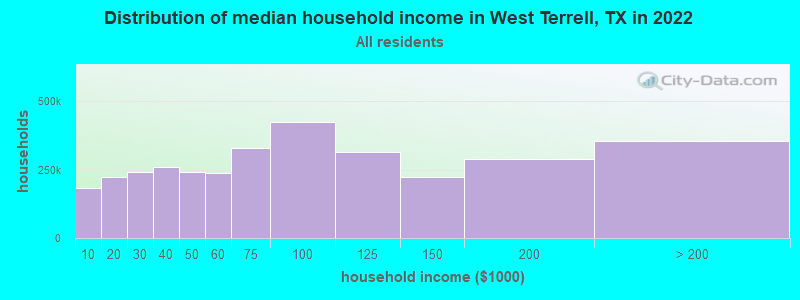
| West Terrell: | $51,482 |
| TX: | $72,284 |
Estimated per capita income in 2022: $37,582 (it was $14,039 in 2000)
West Terrell CCD income, earnings, and wages data
Estimated median house or condo value in 2022: $133,988 (it was $26,000 in 2000)
| West Terrell: | $133,988 |
| TX: | $275,400 |
Mean prices in 2022: all housing units: $156,876; detached houses: $156,313
Detailed information about poverty and poor residents in West Terrell, TX


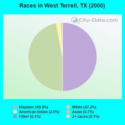
- 45649.9%Hispanic
- 43147.2%White alone
- 182.0%American Indian alone
- 60.7%Asian alone
- 10.1%Other race alone
- 10.1%Two or more races
Races in West Terrell detailed stats: ancestries, foreign born residents, place of birth
 Recent articles from our blog. Our writers, many of them Ph.D. graduates or candidates, create easy-to-read articles on a wide variety of topics.
Current Local Time: CST time zone
Land area: 600.0 square miles.
Population density: 1.3 people per square mile (very low).
| West Terrell CCD: | 0.8% ($199) |
| Texas: | 1.8% ($1,393) |
Nearest city with pop. 50,000+: Odessa, TX  (122.3 miles , pop. 90,943).
Nearest city with pop. 200,000+: San Antonio, TX (235.2 miles , pop. 1,144,646).
Nearest cities:
), )Latitude: 30.10 N, Longitude: 102.36 W
Area code commonly used in this area: 432

| Here: | 2.9% |
| Texas: | 3.5% |
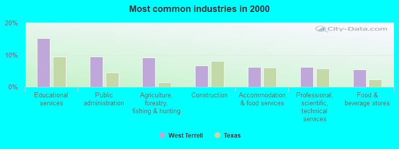
- Educational services (15.2%)
- Public administration (9.5%)
- Agriculture, forestry, fishing & hunting (9.2%)
- Construction (6.7%)
- Accommodation & food services (6.2%)
- Professional, scientific, technical services (6.2%)
- Food & beverage stores (5.5%)
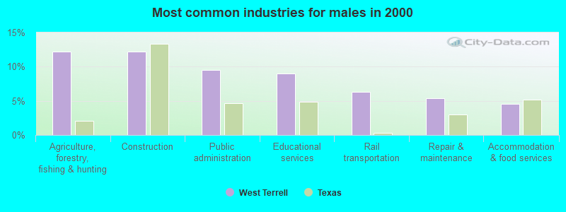
- Agriculture, forestry, fishing & hunting (12.2%)
- Construction (12.2%)
- Public administration (9.5%)
- Educational services (9.0%)
- Rail transportation (6.3%)
- Repair & maintenance (5.4%)
- Accommodation & food services (4.5%)
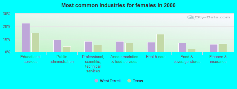
- Educational services (22.7%)
- Public administration (9.4%)
- Professional, scientific, technical services (8.3%)
- Accommodation & food services (8.3%)
- Health care (7.7%)
- Food & beverage stores (7.2%)
- Finance & insurance (6.1%)
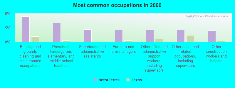
- Building and grounds cleaning and maintenance occupations (9.0%)
- Preschool, kindergarten, elementary, and middle school teachers (6.7%)
- Secretaries and administrative assistants (4.5%)
- Farmers and farm managers (4.2%)
- Other office and administrative support workers, including supervisors (4.2%)
- Other sales and related occupations, including supervisors (4.2%)
- Other construction workers and helpers (4.0%)
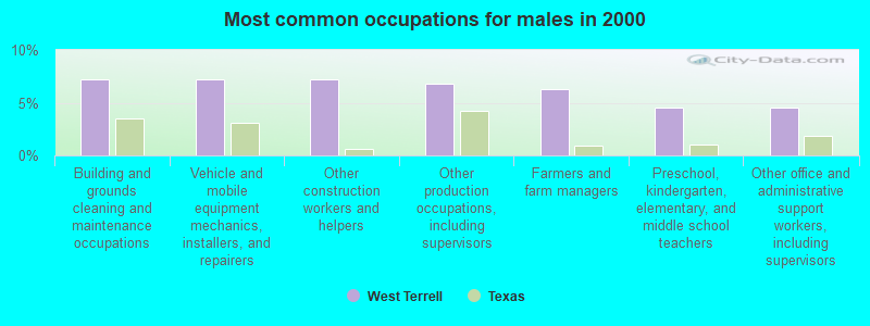
- Building and grounds cleaning and maintenance occupations (7.2%)
- Vehicle and mobile equipment mechanics, installers, and repairers (7.2%)
- Other construction workers and helpers (7.2%)
- Other production occupations, including supervisors (6.8%)
- Farmers and farm managers (6.3%)
- Preschool, kindergarten, elementary, and middle school teachers (4.5%)
- Other office and administrative support workers, including supervisors (4.5%)
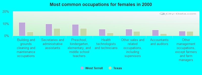
- Building and grounds cleaning and maintenance occupations (11.0%)
- Secretaries and administrative assistants (9.9%)
- Preschool, kindergarten, elementary, and middle school teachers (9.4%)
- Health technologists and technicians (5.5%)
- Other sales and related occupations, including supervisors (5.5%)
- Accountants and auditors (5.0%)
- Other management occupations, except farmers and farm managers (3.9%)
Average climate in West Terrell, Texas
Based on data reported by over 4,000 weather stations


Earthquake activity:
West Terrell-area historical earthquake activity is significantly above Texas state average. It is 19% greater than the overall U.S. average.On 4/14/1995 at 00:32:56, a magnitude 5.7 (5.6 MB, 5.7 MS, 5.7 MW, Depth: 11.1 mi, Class: Moderate, Intensity: VI - VII) earthquake occurred 61.5 miles away from West Terrell center
On 3/26/2020 at 15:16:27, a magnitude 5.0 (5.0 MW, Depth: 5.9 mi) earthquake occurred 150.1 miles away from the city center
On 1/2/1992 at 11:45:35, a magnitude 5.0 (4.6 MB, 5.0 LG, Depth: 3.1 mi) earthquake occurred 161.0 miles away from the city center
On 6/16/1978 at 11:46:54, a magnitude 5.3 (4.4 MB, 4.6 UK, 5.3 ML) earthquake occurred 223.7 miles away from the city center
On 8/28/1995 at 10:46:12, a magnitude 6.9 (5.7 MB, 6.5 MS, 6.9 ME, 6.6 MW, Depth: 7.6 mi, Class: Strong, Intensity: VII - IX) earthquake occurred 557.0 miles away from the city center
On 5/14/2015 at 17:41:14, a magnitude 4.0 (4.0 MB, Depth: 9.8 mi, Class: Light, Intensity: IV - V) earthquake occurred 50.0 miles away from the city center
Magnitude types: regional Lg-wave magnitude (LG), body-wave magnitude (MB), energy magnitude (ME), local magnitude (ML), surface-wave magnitude (MS), moment magnitude (MW)
Natural disasters:
The number of natural disasters in Terrell County (8) is smaller than the US average (15).Major Disasters (Presidential) Declared: 2
Emergencies Declared: 5
Causes of natural disasters: Fires: 3, Hurricanes: 3, Flood: 1, Tornado: 1, Other: 1 (Note: some incidents may be assigned to more than one category).
Colleges/universities with over 2000 students nearest to West Terrell:
- Sul Ross State University (about 80 miles; Alpine, TX; Full-time enrollment: 2,101)
- Odessa College (about 123 miles; Odessa, TX; FT enrollment: 3,107)
- The University of Texas of the Permian Basin (about 125 miles; Odessa, TX; FT enrollment: 2,982)
- Midland College (about 135 miles; Midland, TX; FT enrollment: 3,650)
- Angelo State University (about 147 miles; San Angelo, TX; FT enrollment: 6,019)
- Howard College (about 159 miles; Big Spring, TX; FT enrollment: 2,587)
- Southwest Texas Junior College (about 169 miles; Uvalde, TX; FT enrollment: 3,569)
Points of interest:
Notable locations in West Terrell: Elders Ranch (A), Paso Colorado Crossing (B), Mare Canyon Crossing (C), Brown Ranch (D), Carruthers Ranch (E), Deaton Ranch (F), Downie Ranch (G), Dudley Ranch (H), Goldwire Ranch (I), Hagelstein Ranch (J), Harrell Ranch (K), James Ranch (L), Kerr Ranch (M), Mitchell Ranch (N), Murrah Ranch (O), Odom Ranch (P), Rose Ranch (Q), Wood Ranch (R), Deaf Smith County Library (S), Terrell County Volunteer Fire Department (T). Display/hide their locations on the map
Cemeteries: Cedar Grove Cemetery (1), Santa Rita Cemetery (2). Display/hide their locations on the map
Reservoirs: Soil Conservation Service Site 8 Reservoir (A), Soil Conservation Service Site 9 Reservoir (B), Soil Conservation Service Site 7 Reservoir (C), Soil Conservation Service Site 10 Reservoir (D). Display/hide their locations on the map
Creeks: San Francisco Creek (A), Sanderson Creek (B), Candilla Creek (C), Cedar Creek (D). Display/hide their locations on the map
| This place: | 2.3 people |
| Texas: | 2.8 people |
| This place: | 57.8% |
| Whole state: | 69.9% |
| This place: | 5.3% |
| Whole state: | 6.0% |
Likely homosexual households (counted as self-reported same-sex unmarried-partner households)
- Lesbian couples: 0.0% of all households
- Gay men: 0.5% of all households
| This place: | 26.0% |
| Whole state: | 15.4% |
| This place: | 10.1% |
| Whole state: | 6.7% |
For population 15 years and over in West Terrell:
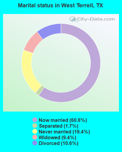
- Never married: 19.4%
- Now married: 60.6%
- Separated: 1.7%
- Widowed: 9.4%
- Divorced: 10.6%
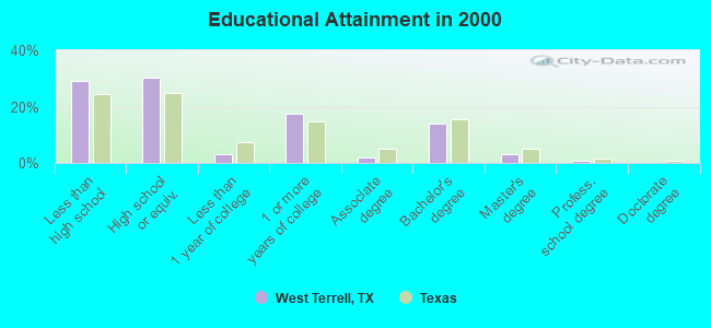
For population 25 years and over in West Terrell:
- High school or higher: 70.8%
- Bachelor's degree or higher: 17.8%
- Graduate or professional degree: 3.8%
- Unemployed: 6.1%
- Mean travel time to work (commute): 16.3 minutes
| Here: | 17.5 |
| Texas average: | 15.6 |
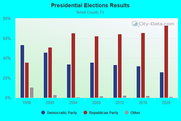
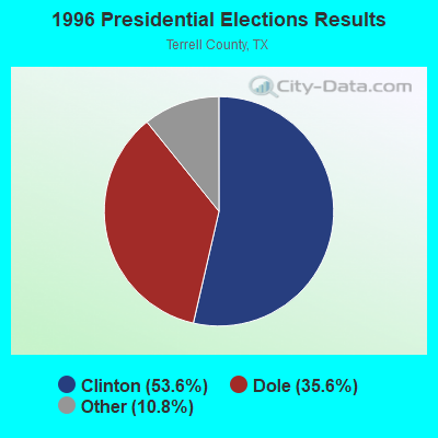
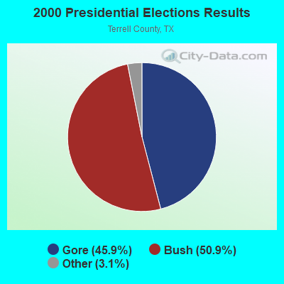
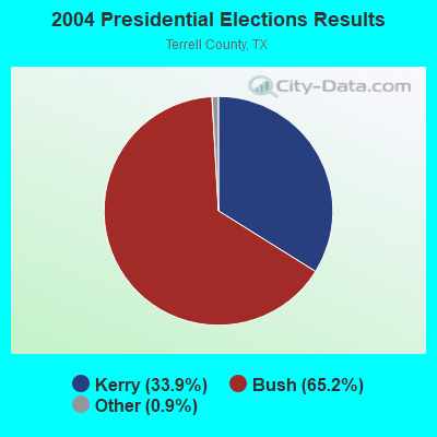
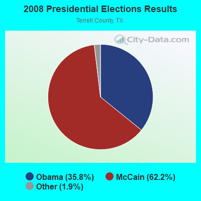

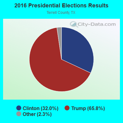
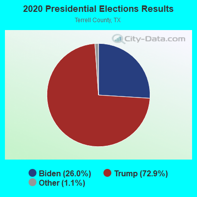
Graphs represent county-level data. Detailed 2008 Election Results
Religion statistics for West Terrell, TX (based on Terrell County data)
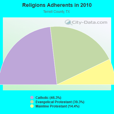
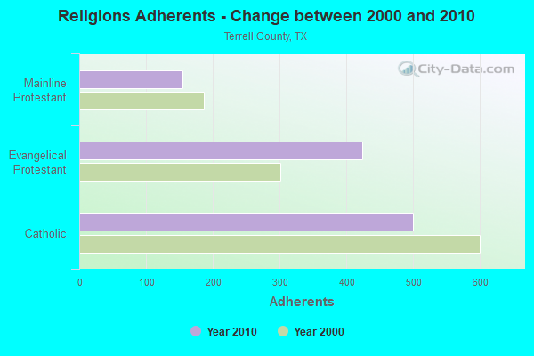
| Religion | Adherents | Congregations |
|---|---|---|
| Catholic | 500 | 1 |
| Evangelical Protestant | 424 | 3 |
| Mainline Protestant | 155 | 4 |
| None | - | - |
Food Environment Statistics:
| Terrell County: | 21.46 / 10,000 pop. |
| Texas: | 3.95 / 10,000 pop. |
| Terrell County: | 10.73 / 10,000 pop. |
| Texas: | 6.13 / 10,000 pop. |
| Here: | 11.6% |
| Texas: | 8.9% |
| This county: | 26.1% |
| State: | 26.6% |
Strongest AM radio stations in West Terrell:
- KKYX (680 AM; 50 kW; SAN ANTONIO, TX; Owner: CXR HOLDINGS, INC.)
- KTKR (760 AM; 50 kW; SAN ANTONIO, TX; Owner: CCB TEXAS LICENSES, L.P.)
- KINF (1020 AM; 50 kW; ROSWELL, NM; Owner: JAMES CRYSTAL HOLDINGS OF NEW MEXICO, INC.)
- WOAI (1200 AM; 50 kW; SAN ANTONIO, TX; Owner: CCB TEXAS LICENSES, L.P.)
- KICA (980 AM; 50 kW; CLOVIS, NM; Owner: BROADCAST ENTERTAINMENT CORPORATION)
- WBAP (820 AM; 50 kW; FORT WORTH, TX; Owner: WBAP-KSCS OPERATING, LTD.)
- KELP (1590 AM; 50 kW; EL PASO, TX; Owner: MCCLATCHEY BROADCASTING)
- KCRS (550 AM; 5 kW; MIDLAND, TX; Owner: CCB TEXAS LICENSES, L.P.)
- KENS (1160 AM; 25 kW; SAN ANTONIO, TX; Owner: KENS-TV, INC.)
- KCTA (1030 AM; 50 kW; CORPUS CHRISTI, TX; Owner: BROADCASTING CORPORATION OF THE SOUTHWEST)
- KMUL (1380 AM; 50 kW; MULESHOE, TX; Owner: BROADCAST ENTERTAINMENT CORPORATION)
- KTRH (740 AM; 50 kW; HOUSTON, TX; Owner: AMFM TEXAS LICENSES LIMITED PARTNERSHIP)
- KKOB (770 AM; 50 kW; ALBUQUERQUE, NM; Owner: CITADEL BROADCASTING COMPANY)
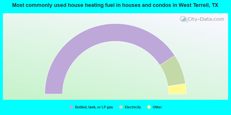
- 81.7%Bottled, tank, or LP gas
- 13.7%Electricity
- 1.9%Utility gas
- 1.9%Other fuel
- 0.9%Fuel oil, kerosene, etc.
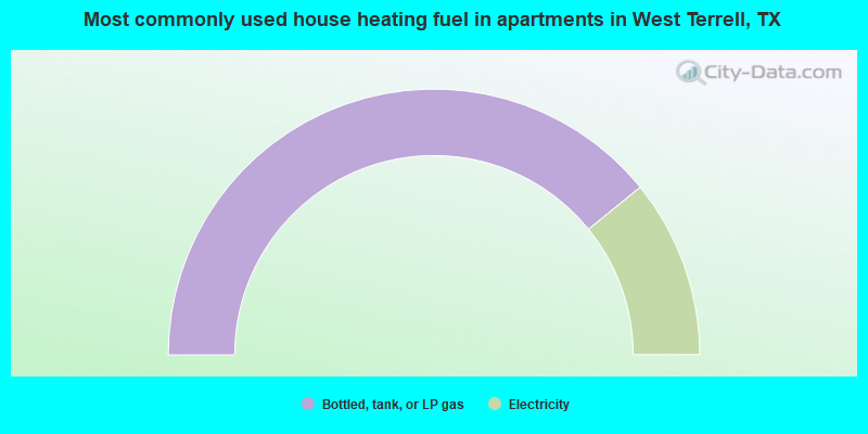
- 78.3%Bottled, tank, or LP gas
- 21.7%Electricity
West Terrell compared to Texas state average:
- Median house value below state average.
- Unemployed percentage below state average.
- Black race population percentage significantly below state average.
- Median age significantly above state average.
- Foreign-born population percentage significantly below state average.
- Length of stay since moving in significantly above state average.
- Number of rooms per house significantly below state average.
- House age significantly below state average.
- Number of college students significantly below state average.