West Wakulla, Florida
Submit your own pictures of this place and show them to the world
- OSM Map
- General Map
- Google Map
- MSN Map

| Males: 3,508 | |
| Females: 3,475 |
| Median resident age: | 40.7 years |
| Florida median age: | 38.7 years |
Zip code: 32358
| West Wakulla: | $63,054 |
| FL: | $69,303 |
Estimated per capita income in 2022: $32,885 (it was $17,698 in 2000)
West Wakulla CCD income, earnings, and wages data
Estimated median house or condo value in 2022: $231,635 (it was $76,900 in 2000)
| West Wakulla: | $231,635 |
| FL: | $354,100 |
Detailed information about poverty and poor residents in West Wakulla, FL
Compare current foreclosures near West Wakulla, FL:
| Photo | Address | Area | Beds / Baths | Price | Details |
|---|---|---|---|---|---|

|
#1
Old Courthouse Way # C
Crawfordville, FL 32327
|
1,328 sq. feet
|
3 baths 3 beds |
show details | |

|
#2
Mallard Pond Cir
Crawfordville, FL 32327
|
1,390 sq. feet
|
2 baths 3 beds |
show details | |

|
#3
Wakulla Arran Rd
Crawfordville, FL 32327
|
564 sq. feet
|
1 baths 2 beds |
show details | |

|
#4
Barber Rd
Crawfordville, FL 32327
|
2,016 sq. feet
|
2 baths 3 beds |
show details | |

|
#5
Sopchoppy Hwy
Sopchoppy, FL 32358
|
1,296 sq. feet
|
1 baths 2 beds |
show details | |

|
#6
Savannah Forest Cir
Crawfordville, FL 32327
|
2,215 sq. feet
|
3 baths 4 beds |
show details | |

|
#7
Farrier Ln
Crawfordville, FL 32327
|
2,282 sq. feet
|
2 baths 3 beds |
show details | |

|
#8
Mccallister Rd
Crawfordville, FL 32327
|
1,760 sq. feet
|
2 baths 4 beds |
show details | |

|
#9
Covington Cir
Crawfordville, FL 32327
|
1,581 sq. feet
|
2 baths 3 beds |
show details | |

|
#10
Shadow Oak Cir
Crawfordville, FL 32327
|
1,891 sq. feet
|
2 baths 3 beds |
show details |
| Photo | Address | Area | Beds / Baths | Price | Details |
|---|---|---|---|---|---|

|
#11
Kenneth Cir
Crawfordville, FL 32327
|
1,290 sq. feet
|
2 baths 2 beds |
show details | |

|
#12
Spokan Trl
Crawfordville, FL 32327
|
1,202 sq. feet
|
2 baths 3 beds |
show details | |

|
#13
Dreamwood Stables Rd
Crawfordville, FL 32327
|
2,280 sq. feet
|
2 baths 4 beds |
show details | |

|
#14
Violet Ln
Crawfordville, FL 32327
|
1,782 sq. feet
|
2 baths 4 beds |
show details | |

|
#15
Cruse Rd
Sopchoppy, FL 32358
|
520 sq. feet
|
1 baths 2 beds |
show details | |

|
#16
Excalibur Dr
Crawfordville, FL 32327
|
1,483 sq. feet
|
2 baths 3 beds |
show details | |

|
#17
Shell Point Rd
Crawfordville, FL 32327
|
- sq. feet
|
- baths - beds |
show details | |

|
#18
Wakulla Arran Rd
Crawfordville, FL 32327
|
- sq. feet
|
- baths - beds |
show details | |

|
#19
Mayfair Dr
Crawfordville, FL 32327
|
- sq. feet
|
- baths - beds |
show details | |

|
#20
Roberts Williams Rd
Crawfordville, FL 32327
|
- sq. feet
|
- baths - beds |
show details |
| Photo | Address | Area | Beds / Baths | Price | Details |
|---|---|---|---|---|---|

|
#21
Oak Park Rd
Sopchoppy, FL 32358
|
- sq. feet
|
- baths - beds |
show details | |

|
#22
Ben Willis Rd
Crawfordville, FL 32327
|
- sq. feet
|
- baths - beds |
show details | |

|
#23
Savannah Forest Cir
Crawfordville, FL 32327
|
- sq. feet
|
- baths - beds |
show details | |

|
#24
Melody Ln
Crawfordville, FL 32327
|
- sq. feet
|
- baths - beds |
show details | |

|
#25
High Dr
Crawfordville, FL 32327
|
- sq. feet
|
- baths - beds |
show details | |

|
#26
Coastal Hwy
Crawfordville, FL 32327
|
- sq. feet
|
- baths - beds |
show details | |

|
#27
Lisa Dr
Crawfordville, FL 32327
|
- sq. feet
|
- baths - beds |
show details | |

|
#28
Evalinda St
Crawfordville, FL 32327
|
- sq. feet
|
- baths - beds |
show details | |

|
#29
Montgomery Dr
Crawfordville, FL 32327
|
- sq. feet
|
- baths - beds |
show details | |

|
#30
John Mills Rd
Sopchoppy, FL 32358
|
- sq. feet
|
- baths - beds |
show details |
| Photo | Address | Area | Beds / Baths | Price | Details |
|---|---|---|---|---|---|

|
#31
Highway 98 E
Carrabelle, FL 32322
|
- sq. feet
|
- baths - beds |
show details | |

|
#32
Duane Dr
Crawfordville, FL 32327
|
- sq. feet
|
- baths - beds |
show details | |

|
Check over 1 million property listings on Foreclosure.com!
|
browse all offers | |||

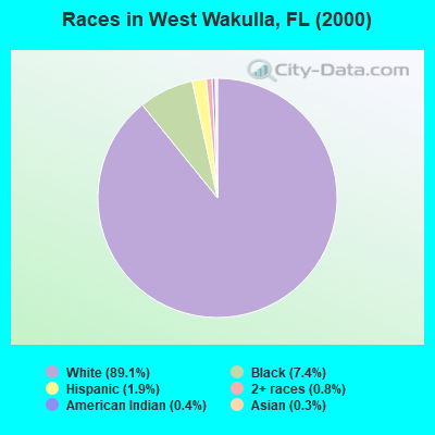
- 4,72889.1%White alone
- 3947.4%Black alone
- 1001.9%Hispanic
- 450.8%Two or more races
- 220.4%American Indian alone
- 140.3%Asian alone
- 30.06%Native Hawaiian and Other
Pacific Islander alone - 20.04%Other race alone
Races in West Wakulla detailed stats: ancestries, foreign born residents, place of birth
 Recent articles from our blog. Our writers, many of them Ph.D. graduates or candidates, create easy-to-read articles on a wide variety of topics.
Current Local Time: EST time zone
Land area: 309.8 square miles.
Population density: 23 people per square mile (very low).
| West Wakulla CCD: | 1.0% ($745) |
| Florida: | 1.4% ($1,262) |
Nearest city with pop. 50,000+: Tallahassee, FL  (28.3 miles , pop. 150,624).
Nearest city with pop. 200,000+: Jacksonville, FL (170.6 miles , pop. 735,617).
Nearest city with pop. 1,000,000+: Houston, TX (652.4 miles , pop. 1,953,631).
Nearest cities:
), ), ), ), )Latitude: 30.09 N, Longitude: 84.50 W
Area code commonly used in this area: 850

| Here: | 2.8% |
| Florida: | 2.9% |

- Public administration (14.2%)
- Construction (13.1%)
- Educational services (9.7%)
- Accommodation & food services (7.7%)
- Professional, scientific, technical services (6.4%)
- Health care (5.3%)
- Food & beverage stores (4.8%)
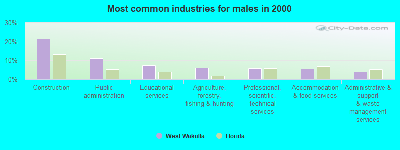
- Construction (21.6%)
- Public administration (11.0%)
- Educational services (7.5%)
- Agriculture, forestry, fishing & hunting (6.1%)
- Professional, scientific, technical services (5.8%)
- Accommodation & food services (5.7%)
- Administrative & support & waste management services (3.8%)
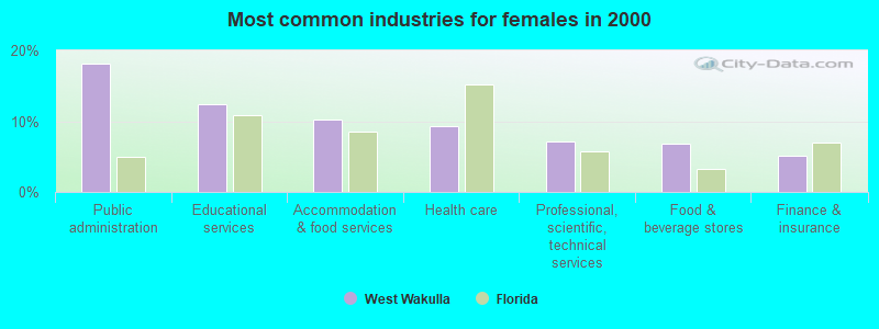
- Public administration (18.2%)
- Educational services (12.4%)
- Accommodation & food services (10.3%)
- Health care (9.3%)
- Professional, scientific, technical services (7.1%)
- Food & beverage stores (6.8%)
- Finance & insurance (5.1%)
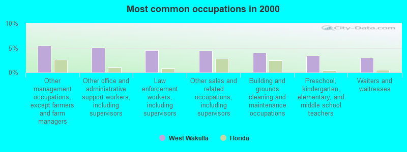
- Other management occupations, except farmers and farm managers (5.4%)
- Other office and administrative support workers, including supervisors (5.0%)
- Law enforcement workers, including supervisors (4.5%)
- Other sales and related occupations, including supervisors (4.4%)
- Building and grounds cleaning and maintenance occupations (4.0%)
- Preschool, kindergarten, elementary, and middle school teachers (3.4%)
- Waiters and waitresses (3.0%)
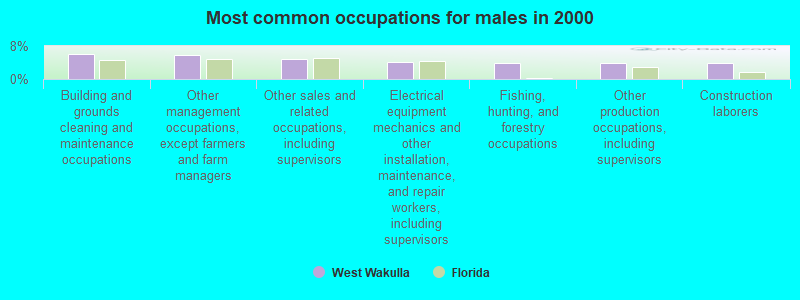
- Building and grounds cleaning and maintenance occupations (6.1%)
- Other management occupations, except farmers and farm managers (5.8%)
- Other sales and related occupations, including supervisors (4.8%)
- Electrical equipment mechanics and other installation, maintenance, and repair workers, including supervisors (4.1%)
- Fishing, hunting, and forestry occupations (4.0%)
- Other production occupations, including supervisors (3.9%)
- Construction laborers (3.8%)
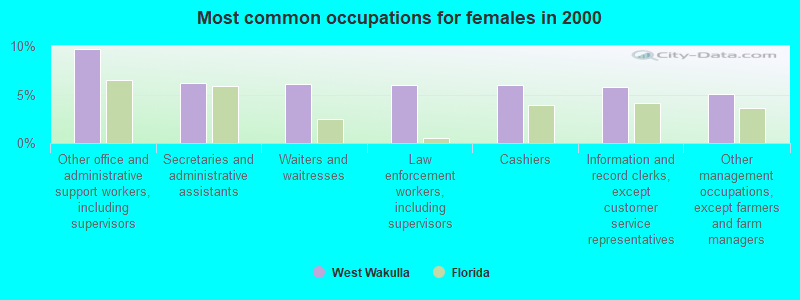
- Other office and administrative support workers, including supervisors (9.7%)
- Secretaries and administrative assistants (6.2%)
- Waiters and waitresses (6.0%)
- Law enforcement workers, including supervisors (5.9%)
- Cashiers (5.9%)
- Information and record clerks, except customer service representatives (5.8%)
- Other management occupations, except farmers and farm managers (5.0%)
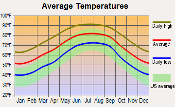
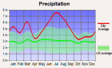
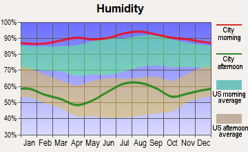
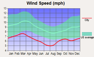
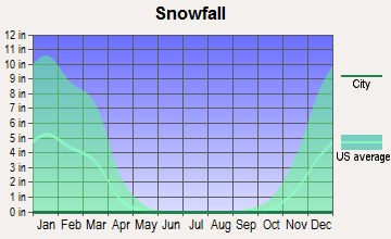
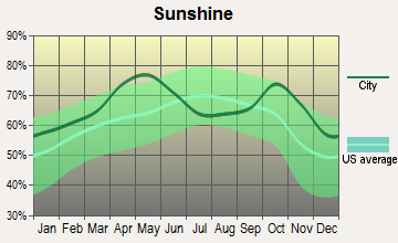
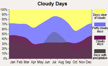
Average climate in West Wakulla, Florida
Based on data reported by over 4,000 weather stations
(lower is better)
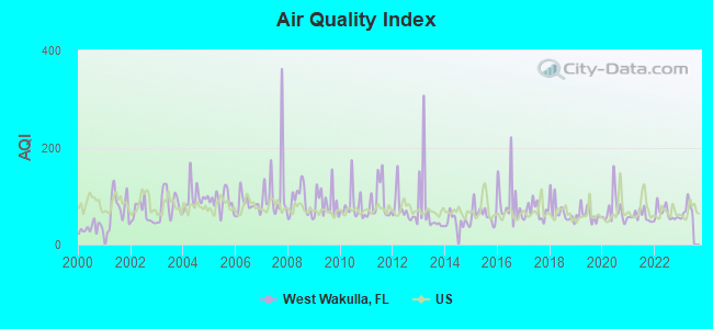
Air Quality Index (AQI) level in 2022 was 64.2. This is about average.
| City: | 64.2 |
| U.S.: | 72.6 |
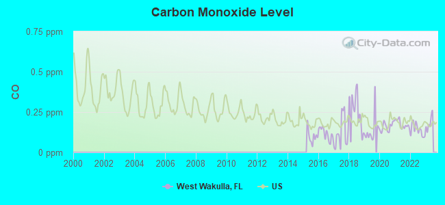
Carbon Monoxide (CO) [ppm] level in 2022 was 0.139. This is significantly better than average. Closest monitor was 20.4 miles away from the city center.
| City: | 0.139 |
| U.S.: | 0.251 |
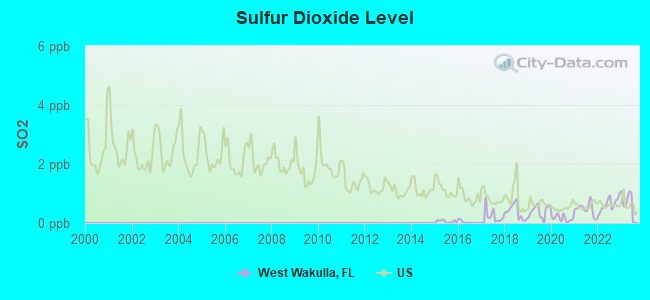
Sulfur Dioxide (SO2) [ppb] level in 2022 was 0.631. This is significantly better than average. Closest monitor was 20.4 miles away from the city center.
| City: | 0.631 |
| U.S.: | 1.515 |
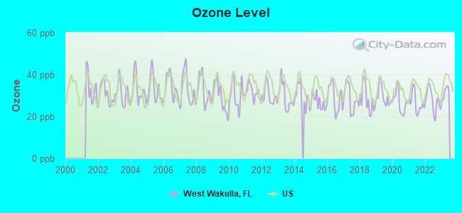
Ozone [ppb] level in 2022 was 27.6. This is better than average. Closest monitor was 20.4 miles away from the city center.
| City: | 27.6 |
| U.S.: | 33.3 |
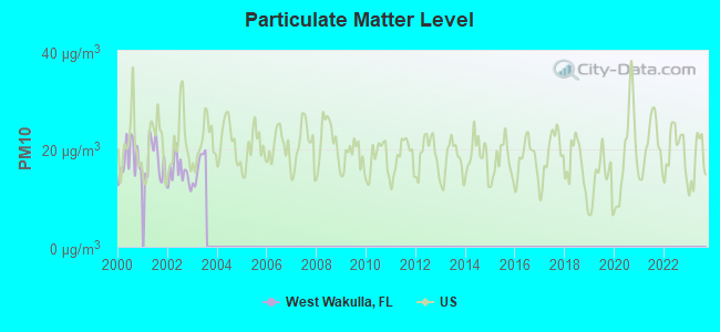
Particulate Matter (PM10) [µg/m3] level in 2003 was 16.4. This is about average. Closest monitor was 15.4 miles away from the city center.
| City: | 16.4 |
| U.S.: | 19.2 |
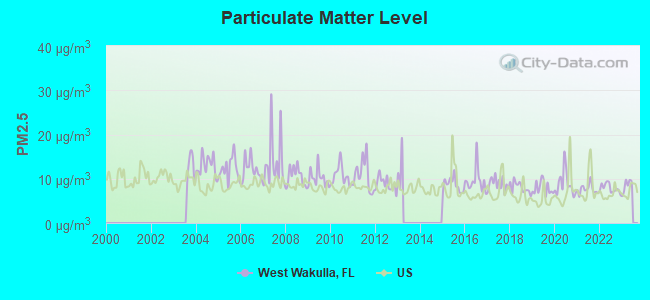
Particulate Matter (PM2.5) [µg/m3] level in 2022 was 7.87. This is about average. There were 0 monitors within city limits.
| City: | 7.87 |
| U.S.: | 8.11 |
Tornado activity:
West Wakulla-area historical tornado activity is slightly below Florida state average. It is 23% smaller than the overall U.S. average.
On 4/25/1964, a category F2 (max. wind speeds 113-157 mph) tornado 8.6 miles away from the West Wakulla place center injured 2 people and caused between $50,000 and $500,000 in damages.
On 10/27/1972, a category F2 tornado 15.9 miles away from the place center caused between $50,000 and $500,000 in damages.
Earthquake activity:
West Wakulla-area historical earthquake activity is significantly above Florida state average. It is 75% smaller than the overall U.S. average.On 9/10/2006 at 14:56:08, a magnitude 5.9 (5.9 MB, 5.5 MS, 5.8 MW, Class: Moderate, Intensity: VI - VII) earthquake occurred 295.8 miles away from West Wakulla center
On 10/24/1997 at 08:35:17, a magnitude 4.9 (4.8 MB, 4.2 MS, 4.9 LG, Depth: 6.2 mi, Class: Light, Intensity: IV - V) earthquake occurred 179.6 miles away from West Wakulla center
On 8/2/1974 at 08:52:09, a magnitude 4.9 (4.3 MB, 4.9 LG) earthquake occurred 286.8 miles away from West Wakulla center
On 1/18/1999 at 07:00:53, a magnitude 4.8 (4.8 MB, 4.0 LG, Depth: 0.6 mi) earthquake occurred 280.4 miles away from the city center
On 4/29/2003 at 08:59:39, a magnitude 4.9 (4.4 MB, 4.6 MW, 4.9 LG) earthquake occurred 311.4 miles away from West Wakulla center
On 5/6/2018 at 16:47:09, a magnitude 4.6 (4.6 MB, Depth: 6.2 mi) earthquake occurred 295.7 miles away from West Wakulla center
Magnitude types: regional Lg-wave magnitude (LG), body-wave magnitude (MB), surface-wave magnitude (MS), moment magnitude (MW)
Natural disasters:
The number of natural disasters in Wakulla County (27) is a lot greater than the US average (15).Major Disasters (Presidential) Declared: 19
Emergencies Declared: 4
Causes of natural disasters: Hurricanes: 13, Tropical Storms: 7, Floods: 4, Fires: 3, Storms: 2, Tornadoes: 2, Winds: 2, Freeze: 1, Other: 1 (Note: some incidents may be assigned to more than one category).
Colleges/universities with over 2000 students nearest to West Wakulla:
- Tallahassee Community College (about 27 miles; Tallahassee, FL; Full-time enrollment: 10,904)
- Florida Agricultural and Mechanical University (about 27 miles; Tallahassee, FL; FT enrollment: 10,841)
- Florida State University (about 28 miles; Tallahassee, FL; FT enrollment: 38,283)
- Bainbridge State College (about 56 miles; Bainbridge, GA; FT enrollment: 2,308)
- Gulf Coast State College (about 74 miles; Panama City, FL; FT enrollment: 4,474)
- Wiregrass Georgia Technical College (about 88 miles; Valdosta, GA; FT enrollment: 3,246)
- Valdosta State University (about 90 miles; Valdosta, GA; FT enrollment: 11,155)
Points of interest:
Notable locations in West Wakulla: Allen Landing (A), Big River Landing (B), Bottoms Fishery (C), Roberts Landing (D), Rock Landing (E), Stokley Landing (F), Pine Creek Landing Campground (G), Upper Langston Landing (H), Mud Landing (I), Ochlockonee Fishery (J), Popes Still Hunt Camp (K), Davis Camp (L), Pope Still (M), Wood Lake Campground (N), Mack Landing Campground (O), Medart Volunteer Fire Department (P), Ochlockonee Bay Volunteer Fire Department (Q), Sopchoppy Fire Department (R), Smith Creek Volunteer Fire Department (S), Panacea Volunteer Fire Department (T). Display/hide their locations on the map
Churches in West Wakulla include: Riverside Baptist Church (A), Saint Johns Church (B), Otter Creek Church (C), Mount Trial Primitive Baptist Church (D), New Home Church (E), Mount Trail Church (F), Mount Olive Church (G), Mount Elan Church (H), Friendship Church (I). Display/hide their locations on the map
Cemeteries: Simmons Cemetery (1), Sanborn McKenzie Cemetery (2), Pelt Cemetery (3), Grimes Cemetery (4), Oak Park Cemetery (5), Arran Cemetery (6), West Sopchoppy Cemetery (7). Display/hide their locations on the map
Lakes and swamps: Cypress Pond (A), Lake Ellen (B), Frog Lake (C), Little Ellen Lake (D), Old Lake (E), Otter Lake (F), Pigott Pond (G), Red Lake (H). Display/hide their locations on the map
Streams, rivers, and creeks: Tide Creek (A), Sopchoppy River (B), Evans Creek (C), Dead River (D), Vause Branch Ochlockonee River (E), Titi Branch (F), Syfrett Creek (G), Smith Creek (H), Schoolhouse Branch (I). Display/hide their locations on the map
Parks in West Wakulla include: Ochlockonee River State Park (1), Apalachicola Wildlife Management Area (2), Morrison Hammock Scenic Area (3). Display/hide their locations on the map
| This place: | 2.4 people |
| Florida: | 2.5 people |
| This place: | 67.4% |
| Whole state: | 65.2% |
| This place: | 7.7% |
| Whole state: | 7.3% |
Likely homosexual households (counted as self-reported same-sex unmarried-partner households)
- Lesbian couples: 0.5% of all households
- Gay men: 0.7% of all households
| This place: | 12.7% |
| Whole state: | 12.5% |
| This place: | 4.5% |
| Whole state: | 5.7% |
For population 15 years and over in West Wakulla:
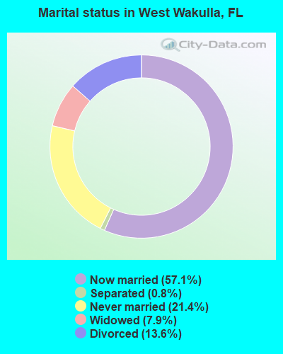
- Never married: 21.4%
- Now married: 57.1%
- Separated: 0.8%
- Widowed: 7.9%
- Divorced: 13.6%
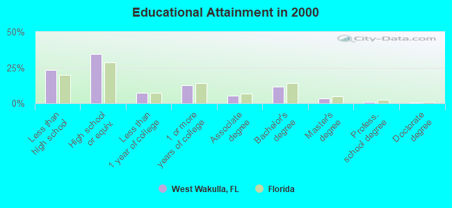
For population 25 years and over in West Wakulla:
- High school or higher: 76.9%
- Bachelor's degree or higher: 17.0%
- Graduate or professional degree: 5.1%
- Unemployed: 4.4%
- Mean travel time to work (commute): 32.5 minutes
| Here: | 13.0 |
| Florida average: | 12.6 |
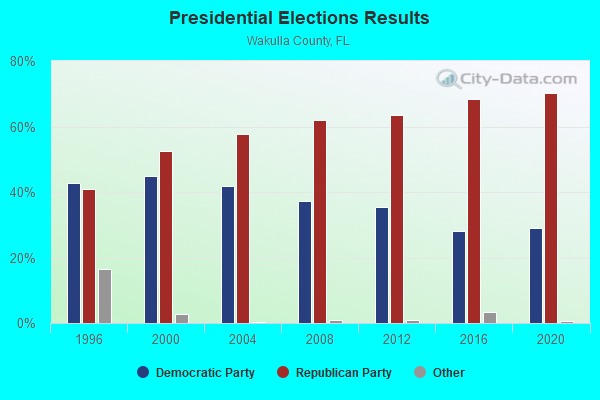
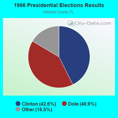
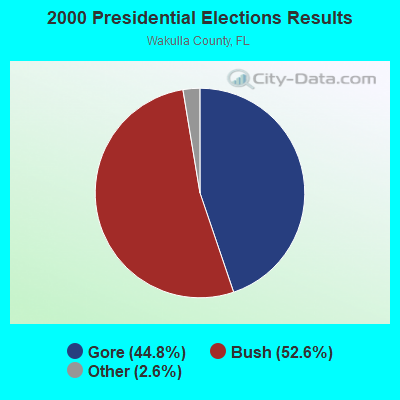
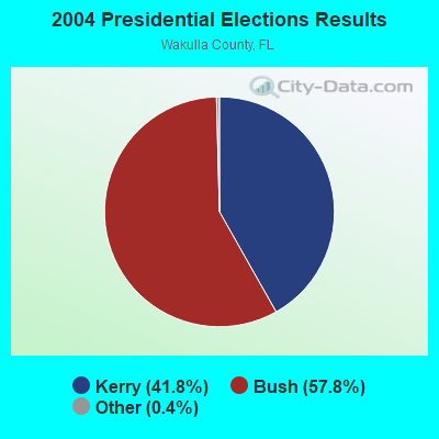
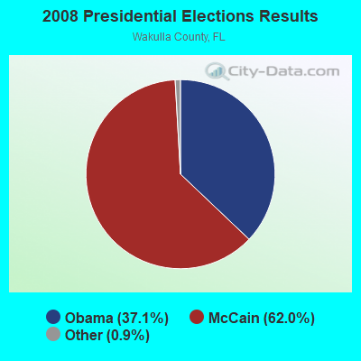

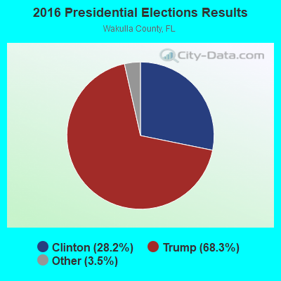
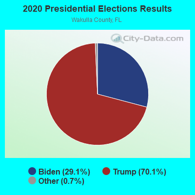
Graphs represent county-level data. Detailed 2008 Election Results
Religion statistics for West Wakulla, FL (based on Wakulla County data)
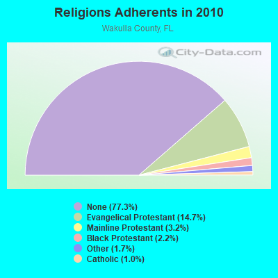
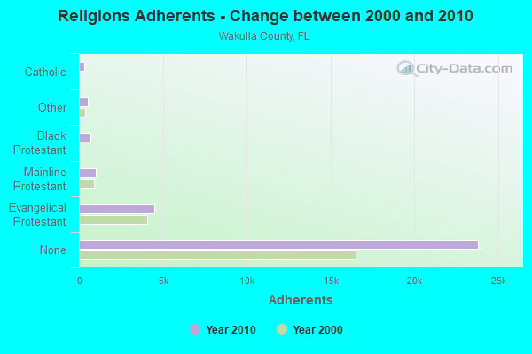
| Religion | Adherents | Congregations |
|---|---|---|
| Evangelical Protestant | 4,514 | 32 |
| Mainline Protestant | 985 | 4 |
| Black Protestant | 664 | 4 |
| Other | 509 | 3 |
| Catholic | 300 | 1 |
| None | 23,804 | - |
Food Environment Statistics:
| Wakulla County: | 1.33 / 10,000 pop. |
| Florida: | 2.04 / 10,000 pop. |
| This county: | 0.33 / 10,000 pop. |
| State: | 1.28 / 10,000 pop. |
| Wakulla County: | 4.32 / 10,000 pop. |
| Florida: | 3.04 / 10,000 pop. |
| This county: | 5.32 / 10,000 pop. |
| State: | 7.45 / 10,000 pop. |
| This county: | 9.3% |
| Florida: | 9.2% |
| Wakulla County: | 28.9% |
| Florida: | 23.7% |
| Wakulla County: | 11.7% |
| Florida: | 14.0% |
Strongest AM radio stations in West Wakulla:
- WSTT (730 AM; 25 kW; THOMASVILLE, GA; Owner: MARION R. WILLIAMS)
- WFRF (1070 AM; daytime; 10 kW; TALLAHASSEE, FL; Owner: FAITH RADIO NETWORK, INC.)
- WNLS (1270 AM; 5 kW; TALLAHASSEE, FL; Owner: CLEAR CHANNEL BROADCASTING LICENSES, INC.)
- WFVR (910 AM; 50 kW; VALDOSTA, GA; Owner: RAMA COMMUNICATIONS, INC.)
- WCVC (1330 AM; daytime; 5 kW; TALLAHASSEE, FL)
- WHBT (1410 AM; 5 kW; TALLAHASSEE, FL)
- WHGH (840 AM; daytime; 10 kW; THOMASVILLE, GA; Owner: H. G. H INVESTMENT CORP.)
- WTCL (1580 AM; daytime; 10 kW; CHATTAHOOCHEE, FL; Owner: METZ, INC.)
- WYBT (1000 AM; daytime; 5 kW; BLOUNTSTOWN, FL; Owner: BLOUNTSTOWN COMMUNICATIONS, INC.)
- WOKV (690 AM; 50 kW; JACKSONVILLE, FL; Owner: COX RADIO, INC.)
- WJEP (1020 AM; daytime; 10 kW; OCHLOCKNEE, GA; Owner: LIFELINE MINISTRIES, INCORPORATED)
- WFLF (540 AM; 50 kW; PINE HILLS, FL; Owner: CLEAR CHANNEL BROADCASTING LICENSES, INC.)
- WMGG (820 AM; 50 kW; LARGO, FL; Owner: MEGA COMMUNICATIONS OF ST. PETERSBURG LICENSEE)
Strongest FM radio stations in West Wakulla:
- WAKU (94.1 FM; CRAWFORDVILLE, FL; Owner: ALTRUA INVESTMENTS INTERNATIONAL COR)
- WFSQ (91.5 FM; TALLAHASSEE, FL; Owner: FLORIDA STATE UNIVERSITY)
- WWLD (102.3 FM; CAIRO, GA; Owner: CUMULUS LICENSING CORP.)
- WGLF (104.1 FM; TALLAHASSEE, FL; Owner: CUMULUS LICENSING CORP.)
- WHBX (96.1 FM; TALLAHASSEE, FL; Owner: CUMULUS LICENSING CORP.)
- WPAP-FM (92.5 FM; PANAMA CITY, FL; Owner: CLEAR CHANNEL BROADCASTING LICENSES, INC.)
- WTNT-FM (94.9 FM; TALLAHASSEE, FL; Owner: CLEAR CHANNEL BROADCASTING LICENSES, INC.)
- WTLY (107.1 FM; THOMASVILLE, GA; Owner: CLEAR CHANNEL BROADCASTING LICENSES, INC.)
- WOCY (106.5 FM; CARRABELLE, FL; Owner: RICHARD L. PLESSINGER, SR.)
- WBZE (98.9 FM; TALLAHASSEE, FL; Owner: CUMULUS LICENSING CORP.)
- WHTF (104.9 FM; HAVANA, FL; Owner: MONTEREY LICENSES, LLC)
- WAIB (103.1 FM; TALLAHASSEE, FL; Owner: MONTEREY LICENSES, LLC)
- WEGT (99.9 FM; LAFAYETTE, FL; Owner: MONTEREY LICENSES, LLC)
- WXSR (101.5 FM; QUINCY, FL; Owner: CLEAR CHANNEL BROADCASTING LICENSES, INC.)
- WBWT (100.7 FM; MIDWAY, FL; Owner: CLEAR CHANNEL BROADCASTING LICENSES, INC.)
- WUTL (106.1 FM; TALLAHASSEE, FL; Owner: MONTEREY LICENSES, LLC)
TV broadcast stations around West Wakulla:
- WFSU-TV (Channel 11; TALLAHASSEE, FL; Owner: FLORIDA STATE UNIVERSITY)
- WTXL-TV (Channel 27; TALLAHASSEE, FL; Owner: MEDIA VENTURE MANAGEMENT, INC.)
- WTLH (Channel 49; BAINBRIDGE, GA; Owner: WTLH LICENSE CORP.)
- WTWC-TV (Channel 40; TALLAHASSEE, FL; Owner: WTWC LICENSEE, LLC)
- WCTV (Channel 6; THOMASVILLE, GA; Owner: WCTV LICENSEE CORP.)
- WVUP-CA (Channel 45; TALLAHASSEE, FL; Owner: CHRISTIAN TELEVISION CORPORATION, INC.)
- WTBC-LP (Channel 65; TALLAHASSEE, FL; Owner: TEMPLE BAPTIST CHURCH, INC.)
- W35BN (Channel 35; TALLAHASSEE, FL; Owner: DEEPAK VISWANATH)
- WBXT-CA (Channel 56; TALLAHASSEE, FL; Owner: THE BOX WORLDWIDE LLC)
- National Bridge Inventory (NBI) Statistics
- 1Number of bridges
- 46ft / 13.8mTotal length
- 1,600Total average daily traffic
- 64Total average daily truck traffic
- 2,776Total future (year 2042) average daily traffic
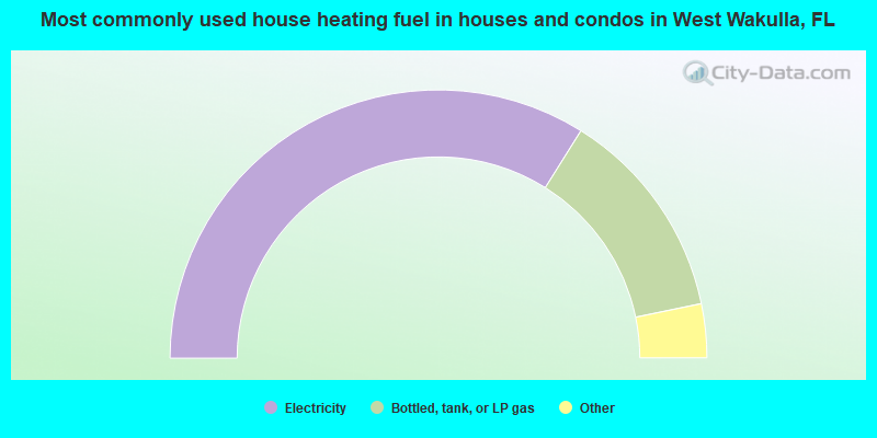
- 67.9%Electricity
- 25.7%Bottled, tank, or LP gas
- 4.0%Wood
- 1.4%Fuel oil, kerosene, etc.
- 0.7%No fuel used
- 0.4%Utility gas
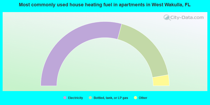
- 58.4%Electricity
- 36.1%Bottled, tank, or LP gas
- 2.9%Utility gas
- 1.7%No fuel used
- 1.0%Fuel oil, kerosene, etc.
West Wakulla compared to Florida state average:
- Median house value below state average.
- Unemployed percentage significantly below state average.
- Black race population percentage below state average.
- Hispanic race population percentage significantly below state average.
- Foreign-born population percentage significantly below state average.
- Renting percentage below state average.
- Length of stay since moving in significantly above state average.
- Number of rooms per house significantly below state average.
- House age significantly below state average.
West Wakulla on our top lists:
- #12 on the list of "Top 101 cities with largest percentage of females in occupations: extraction workers (population 5,000+)"
- #15 on the list of "Top 101 cities with largest percentage of males in occupations: fishing and hunting, and forest and logging workers (population 5,000+)"
- #17 on the list of "Top 101 cities with largest percentage of females in occupations: waiters and waitresses (population 5,000+)"
- #18 on the list of "Top 101 cities with largest percentage of females in industries: professional and commercial equipment and supplies merchant wholesalers (population 5,000+)"
- #20 on the list of "Top 101 cities with largest percentage of females in occupations: bus drivers (population 5,000+)"
- #27 on the list of "Top 101 cities with largest percentage of males in occupations: drafters, engineering, and mapping technicians (population 5,000+)"
- #27 on the list of "Top 101 cities with largest percentage of males in occupations: food processing workers (population 5,000+)"
- #30 on the list of "Top 101 cities with largest percentage of females in industries: food and beverage stores (population 5,000+)"
- #48 on the list of "Top 101 cities with largest percentage of females in industries: groceries and related products merchant wholesalers (population 5,000+)"
- #49 on the list of "Top 101 cities with largest percentage of females in industries: other transportation, and support activities, and couriers (population 5,000+)"
- #62 on the list of "Top 101 cities with largest percentage of males in industries: water transportation (population 5,000+)"
- #77 on the list of "Top 101 cities with largest percentage of females in industries: sewing, needlework, and piece goods stores (population 5,000+)"
- #81 on the list of "Top 101 cities with largest percentage of males in industries: paper and paper products merchant wholesalers (population 5,000+)"
- #84 on the list of "Top 101 cities with largest percentage of females in industries: miscellaneous durable goods merchant wholesalers (population 5,000+)"
- #86 on the list of "Top 101 cities with largest percentage of females in industries: wood products (population 5,000+)"
- #91 on the list of "Top 101 cities with largest percentage of females in industries: public administration (population 5,000+)"