Westfield, Vermont

Submit your own pictures of this town and show them to the world
- OSM Map
- General Map
- Google Map
- MSN Map
Population change since 2000: +6.6%
 |
| Males: 262 | |
| Females: 274 |
| Median resident age: | 49.4 years |
| Vermont median age: | 45.8 years |
Zip codes: 05874.
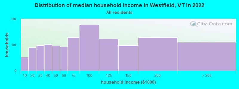
| Westfield: | $78,235 |
| VT: | $73,991 |
Estimated per capita income in 2022: $38,168 (it was $18,098 in 2000)
Westfield town income, earnings, and wages data
Estimated median house or condo value in 2022: $237,380 (it was $88,900 in 2000)
| Westfield: | $237,380 |
| VT: | $304,700 |
Mean prices in 2022: all housing units: $271,502; detached houses: $290,446; townhouses or other attached units: $299,602; in 2-unit structures: $159,589; in 3-to-4-unit structures: $395,771; in 5-or-more-unit structures: $253,965; mobile homes: $74,912
Detailed information about poverty and poor residents in Westfield, VT


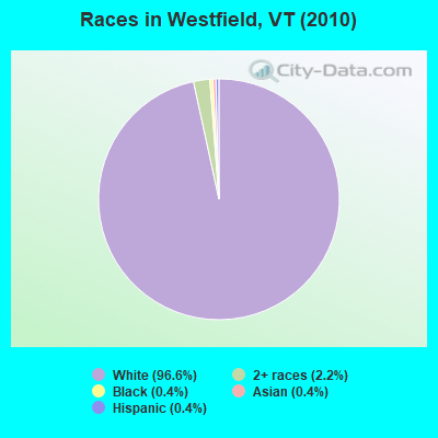
- 51896.6%White alone
- 122.2%Two or more races
- 20.4%Black alone
- 20.4%Asian alone
- 20.4%Hispanic
Races in Westfield detailed stats: ancestries, foreign born residents, place of birth
According to our research of Vermont and other state lists, there were 3 registered sex offenders living in Westfield, Vermont as of May 18, 2024.
The ratio of all residents to sex offenders in Westfield is 179 to 1.
 Recent articles from our blog. Our writers, many of them Ph.D. graduates or candidates, create easy-to-read articles on a wide variety of topics.

 | Vermont Weather (3779 replies) |
| Vermont Rail Ideas (125 replies) |
| Official Vermont Picture Thread (966 replies) |
| NEK relocation from OK. (9 replies) |
| Favorite Vermont cheese? (6 replies) |
| Is it difficult to live a Walden lifestyle in Vermont? (23 replies) |
Latest news from Westfield, VT collected exclusively by city-data.com from local newspapers, TV, and radio stations
Ancestries: French (28.6%), Irish (13.9%), English (11.7%), Italian (9.1%), French Canadian (7.4%), United States (7.4%).
Current Local Time: EST time zone
Elevation: 825 feet
Land area: 40.2 square miles.
Population density: 13 people per square mile (very low).
23 residents are foreign born (2.8% North America, 1.0% Europe, 0.8% Asia).
| This town: | 4.6% |
| Vermont: | 3.8% |
| Westfield town: | 1.6% ($1,463) |
| Vermont: | 2.0% ($2,196) |
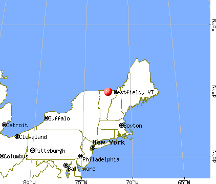
Nearest city with pop. 50,000+: Portland, ME  (136.2 miles , pop. 64,249).
Nearest city with pop. 200,000+: Boston, MA (188.7 miles , pop. 589,141).
Nearest city with pop. 1,000,000+: Bronx, NY (287.3 miles , pop. 1,332,650).
Nearest cities:
), ), ), ), ), Latitude: 44.87 N, Longitude: 72.45 W
Area code commonly used in this area: 802

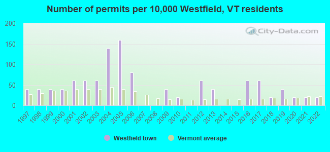
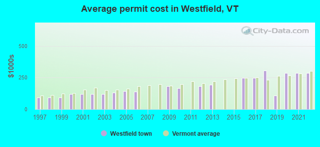
Single-family new house construction building permits:
- 2022: 1 building, cost: $284,700
- 2021: 1 building, cost: $284,700
- 2020: 1 building, cost: $284,700
- 2019: 2 buildings, average cost: $110,300
- 2018: 1 building, cost: $304,400
- 2017: 3 buildings, average cost: $246,000
- 2016: 3 buildings, average cost: $246,000
- 2013: 2 buildings, average cost: $193,300
- 2012: 3 buildings, average cost: $180,300
- 2010: 1 building, cost: $165,900
- 2009: 2 buildings, average cost: $180,600
- 2006: 4 buildings, average cost: $139,300
- 2005: 8 buildings, average cost: $141,500
- 2004: 7 buildings, average cost: $132,800
- 2003: 3 buildings, average cost: $118,000
- 2002: 3 buildings, average cost: $118,000
- 2001: 3 buildings, average cost: $118,000
- 2000: 2 buildings, average cost: $118,000
- 1999: 2 buildings, average cost: $91,700
- 1998: 2 buildings, average cost: $91,700
- 1997: 2 buildings, average cost: $91,700
| Here: | 1.0% |
| Vermont: | 2.0% |
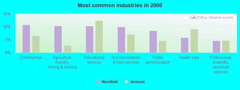
- Construction (10.8%)
- Agriculture, forestry, fishing & hunting (10.4%)
- Educational services (10.4%)
- Accommodation & food services (10.0%)
- Public administration (8.5%)
- Health care (5.8%)
- Professional, scientific, technical services (4.6%)
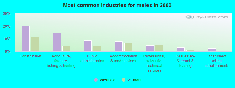
- Construction (20.5%)
- Agriculture, forestry, fishing & hunting (15.0%)
- Public administration (8.7%)
- Accommodation & food services (7.9%)
- Professional, scientific, technical services (4.7%)
- Real estate & rental & leasing (3.1%)
- Other direct selling establishments (2.4%)
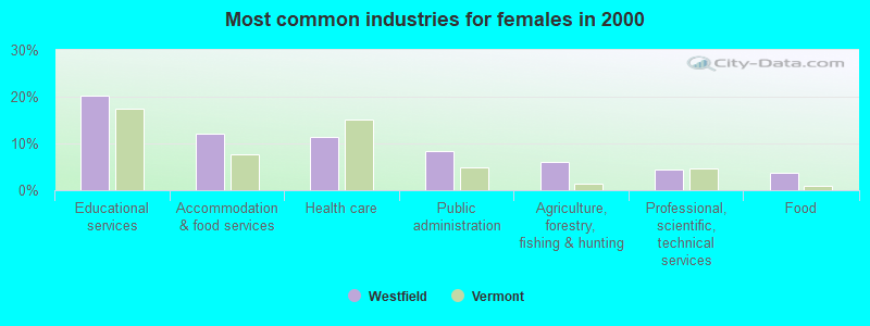
- Educational services (20.3%)
- Accommodation & food services (12.0%)
- Health care (11.3%)
- Public administration (8.3%)
- Agriculture, forestry, fishing & hunting (6.0%)
- Professional, scientific, technical services (4.5%)
- Food (3.8%)
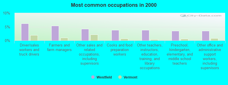
- Driver/sales workers and truck drivers (6.2%)
- Farmers and farm managers (5.4%)
- Other sales and related occupations, including supervisors (4.2%)
- Cooks and food preparation workers (3.8%)
- Other teachers, instructors, education, training, and library occupations (3.8%)
- Preschool, kindergarten, elementary, and middle school teachers (3.5%)
- Other office and administrative support workers, including supervisors (3.5%)
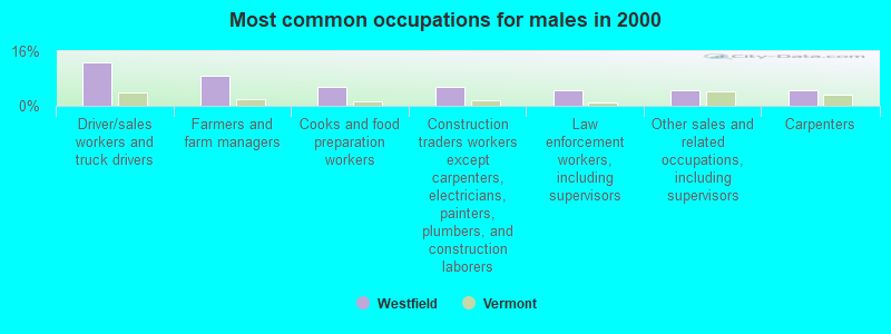
- Driver/sales workers and truck drivers (12.6%)
- Farmers and farm managers (8.7%)
- Cooks and food preparation workers (5.5%)
- Construction traders workers except carpenters, electricians, painters, plumbers, and construction laborers (5.5%)
- Law enforcement workers, including supervisors (4.7%)
- Other sales and related occupations, including supervisors (4.7%)
- Carpenters (4.7%)
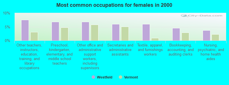
- Other teachers, instructors, education, training, and library occupations (7.5%)
- Preschool, kindergarten, elementary, and middle school teachers (6.8%)
- Other office and administrative support workers, including supervisors (6.8%)
- Secretaries and administrative assistants (6.0%)
- Textile, apparel, and furnishings workers (6.0%)
- Bookkeeping, accounting, and auditing clerks (4.5%)
- Nursing, psychiatric, and home health aides (3.8%)
Average climate in Westfield, Vermont
Based on data reported by over 4,000 weather stations


Earthquake activity:
Westfield-area historical earthquake activity is significantly above Vermont state average. It is 77% smaller than the overall U.S. average.On 4/20/2002 at 10:50:47, a magnitude 5.3 (5.3 ML, Depth: 3.0 mi, Class: Moderate, Intensity: VI - VII) earthquake occurred 66.2 miles away from the city center
On 4/20/2002 at 10:50:47, a magnitude 5.2 (5.2 MB, 4.2 MS, 5.2 MW, 5.0 MW) earthquake occurred 67.8 miles away from Westfield center
On 10/7/1983 at 10:18:46, a magnitude 5.3 (5.1 MB, 5.3 LG, 5.1 ML) earthquake occurred 113.0 miles away from Westfield center
On 1/19/1982 at 00:14:42, a magnitude 4.7 (4.5 MB, 4.7 MD, 4.5 LG, Class: Light, Intensity: IV - V) earthquake occurred 103.4 miles away from the city center
On 10/16/2012 at 23:12:25, a magnitude 4.7 (4.7 ML, Depth: 10.0 mi) earthquake occurred 124.8 miles away from Westfield center
On 6/16/1995 at 12:13:11, a magnitude 3.8 (3.8 LG, Depth: 3.1 mi, Class: Light, Intensity: II - III) earthquake occurred 47.9 miles away from Westfield center
Magnitude types: regional Lg-wave magnitude (LG), body-wave magnitude (MB), duration magnitude (MD), local magnitude (ML), surface-wave magnitude (MS), moment magnitude (MW)
Natural disasters:
The number of natural disasters in Orleans County (23) is greater than the US average (15).Major Disasters (Presidential) Declared: 17
Emergencies Declared: 2
Causes of natural disasters: Floods: 16, Storms: 14, Tropical Storms: 2, Winds: 2, Winter Storms: 2, Heavy Rain: 1, Hurricane: 1, Landslide: 1, Snowstorm: 1, Tornado: 1, Other: 1 (Note: some incidents may be assigned to more than one category).

Hospitals and medical centers near Westfield:
- FLETCHER ALLEN HEALTHCARE - NORTH COUNTRY DIALYSIS UNIT (Dialysis Facility, about 14 miles away; NEWPORT, VT)
- NORTH COUNTRY HOSPITAL AND HEALTH CENTER Critical Access Hospitals (about 14 miles away; NEWPORT, VT)
- ORLEANS ESSEX VNA AND HOSPICE (Home Health Center, about 14 miles away; NEWPORT, VT)
- NEWPORT HEALTH CARE CENTER (Nursing Home, about 14 miles away; NEWPORT, VT)
- MAPLE LANE NURSING HOME (Nursing Home, about 14 miles away; BARTON, VT)
Colleges/universities with over 2000 students nearest to Westfield:
- Saint Michael's College (about 44 miles; Colchester, VT; Full-time enrollment: 2,336)
- Community College of Vermont (about 45 miles; Winooski, VT; FT enrollment: 3,394)
- University of Vermont (about 46 miles; Burlington, VT; FT enrollment: 11,566)
- Champlain College (about 47 miles; Burlington, VT; FT enrollment: 2,623)
- Norwich University (about 52 miles; Northfield, VT; FT enrollment: 4,221)
- SUNY College at Plattsburgh (about 52 miles; Plattsburgh, NY; FT enrollment: 5,934)
- Middlebury College (about 70 miles; Middlebury, VT; FT enrollment: 3,077)
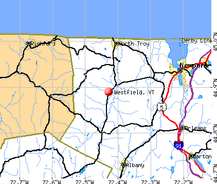
Points of interest:
Notable locations in Westfield: Mill Brook Campground (A), Jay Camp (B). Display/hide their locations on the map
Cemeteries: Westfield North Cemetery (1), Westfield Association Cemetery (2). Display/hide their locations on the map
Reservoir: Phillips Pond (A). Display/hide its location on the map
Streams, rivers, and creeks: Taft Brook (A), Snider Brook (B), Mineral Spring Brook (C), Mill Brook (D), Lilly Branch (E). Display/hide their locations on the map
Park in Westfield: Hazens Notch State Forest Park (1). Display/hide its location on the map
Birthplace of: Thomas J. Boynton (Massachusetts) - Attorney and mayor, Carroll S. Page - Politician.
Drinking water stations with addresses in Westfield and their reported violations in the past:
TROY WATER SYSTEM (Address: 868 SANVILLE RD , Population served: 315, Groundwater):Past health violations:MILL BROOK CAMPGROUND (Population served: 120, Groundwater):Past monitoring violations:
- MCL, Average - Between JAN-2010 and MAR-2010, Contaminant: Arsenic. Follow-up actions: St Public Notif requested (APR-08-2010), St Tech Assistance Visit (APR-08-2010), St Formal NOV issued (APR-08-2010), St Compliance achieved (AUG-02-2010), St Public Notif received (SEP-30-2010)
- MCL, Average - Between OCT-2009 and DEC-2009, Contaminant: Arsenic. Follow-up actions: St Public Notif requested (FEB-02-2010), St Tech Assistance Visit (FEB-02-2010), St Formal NOV issued (FEB-02-2010), St Public Notif received (MAR-17-2010), St Compliance achieved (AUG-02-2010)
- MCL, Average - Between JUL-2009 and SEP-2009, Contaminant: Arsenic. Follow-up actions: St Public Notif requested (OCT-14-2009), St Tech Assistance Visit (OCT-14-2009), St Formal NOV issued (OCT-14-2009), St Public Notif received (JAN-04-2010), St Compliance achieved (AUG-02-2010)
- MCL, Average - Between APR-2009 and JUN-2009, Contaminant: Arsenic. Follow-up actions: St Public Notif received (JUN-22-2009), St Public Notif requested (JUL-16-2009), St Tech Assistance Visit (JUL-16-2009), St Formal NOV issued (JUL-16-2009), St Compliance achieved (AUG-02-2010)
- MCL, Average - Between JAN-2009 and MAR-2009, Contaminant: Arsenic. Follow-up actions: St Public Notif requested (APR-29-2009), St Tech Assistance Visit (APR-29-2009), St Formal NOV issued (APR-29-2009), St Public Notif received (JUN-15-2009), St Compliance achieved (AUG-02-2010)
- MCL, Average - Between OCT-2008 and DEC-2008, Contaminant: Arsenic. Follow-up actions: St Formal NOV issued (MAR-17-2009), St Tech Assistance Visit (MAR-17-2009), St Public Notif requested (MAR-17-2009), St Compliance achieved (AUG-02-2010)
- 12 other older health violations
- One regular monitoring violation
Past health violations:WESTFIELD FIRE DISTRICT 1 (Population served: 120, Groundwater):Past monitoring violations:
- MCL, Monthly (TCR) - In JUN-2011, Contaminant: Coliform. Follow-up actions: St Tech Assistance Visit (JUN-24-2011), St Formal NOV issued (JUN-24-2011), St Public Notif requested (JUN-24-2011), St Boil Water Order (JUN-24-2011), St Compliance achieved (JUL-25-2011)
- Monitoring, Repeat Major (TCR) - In JUL-2012, Contaminant: Coliform (TCR). Follow-up actions: St Public Notif requested (AUG-28-2012), St Formal NOV issued (AUG-28-2012), St Compliance achieved (SEP-30-2013)
- 2 routine major monitoring violations
Past health violations:BARREWOOD CAMPGROUND (Address: 3004 VT RTE 100 , Population served: 102, Groundwater):Past monitoring violations:
- OCCT/SOWT Study/Recommendation - In OCT-21-2009, Contaminant: Lead and Copper Rule. Follow-up actions: St Formal NOV issued (APR-30-2010), St Compliance achieved (OCT-20-2010)
- Monitoring and Reporting (DBP) - Between APR-2014 and JUN-2014, Contaminant: Chlorine
- Initial, Follow-up, or Routine Source Water M/R - In APR-02-2010, Contaminant: Lead and Copper Rule. Follow-up actions: St Formal NOV issued (APR-30-2010), St Compliance achieved (OCT-20-2010)
- Monitoring and Reporting (DBP) - Between JAN-2010 and MAR-2010, Contaminant: Chlorine. Follow-up actions: St Formal NOV issued (MAR-04-2010), St Public Notif requested (MAR-04-2010), St Compliance achieved (SEP-27-2010), St Public Notif received (APR-04-2011)
- Water Quality Parameter M/R - Between OCT-2009 and DEC-2009, Contaminant: Lead and Copper Rule. Follow-up actions: St Formal NOV issued (APR-30-2010), St Compliance achieved (2 times from SEP-27-2010 to NOV-16-2010)
- Monitoring and Reporting (DBP) - Between JUL-2009 and SEP-2009, Contaminant: Total Haloacetic Acids (HAA5). Follow-up actions: St Formal NOV issued (DEC-07-2009), St Tech Assistance Visit (DEC-07-2009), St Public Notif requested (DEC-07-2009), St Public Notif received (JUN-28-2010), St Compliance achieved (SEP-27-2010)
- 6 routine major monitoring violations
- 49 regular monitoring violations
- 11 other older monitoring violations
Past monitoring violations:ST ONGES HIDDEN COUNTRY (Address: 201 POPE ROAD , Population served: 66, Groundwater):
- 13 routine major monitoring violations
- 4 regular monitoring violations
Past health violations:B W SNACK BAR (Address: 5261 LOOP RD , Population served: 40, Groundwater):Past monitoring violations:
- MCL, Monthly (TCR) - In AUG-2006, Contaminant: Coliform. Follow-up actions: St Formal NOV issued (AUG-30-2006), St Tech Assistance Visit (AUG-30-2006), St Public Notif requested (AUG-30-2006), St Boil Water Order (AUG-30-2006)
- MCL, Monthly (TCR) - Between JUL-2006 and SEP-2006, Contaminant: Coliform. Follow-up actions: St Tech Assistance Visit (JUL-13-2006), St Boil Water Order (JUL-13-2006), St Public Notif requested (JUL-13-2006), St Formal NOV issued (JUL-13-2006), St Compliance achieved (MAY-10-2007)
- 10 routine major monitoring violations
- 4 regular monitoring violations
Past monitoring violations:
- One minor monitoring violation
| This town: | 2.3 people |
| Vermont: | 2.3 people |
| This town: | 66.5% |
| Whole state: | 62.5% |
| This town: | 12.3% |
| Whole state: | 9.2% |
Likely homosexual households (counted as self-reported same-sex unmarried-partner households)
- Lesbian couples: 0.0% of all households
- Gay men: 0.4% of all households
| This town: | 9.7% |
| Whole state: | 9.4% |
| This town: | 4.8% |
| Whole state: | 3.6% |
13 people in other group homes in 2000
For population 15 years and over in Westfield:
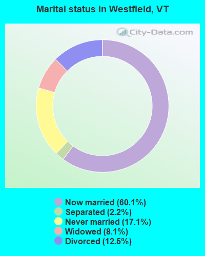
- Never married: 17.1%
- Now married: 60.1%
- Separated: 2.2%
- Widowed: 8.1%
- Divorced: 12.5%
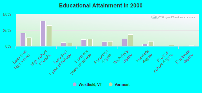
For population 25 years and over in Westfield:
- High school or higher: 78.9%
- Bachelor's degree or higher: 15.4%
- Graduate or professional degree: 3.9%
- Unemployed: 6.5%
- Mean travel time to work (commute): 25.9 minutes
| Here: | 8.9 |
| Vermont average: | 11.7 |
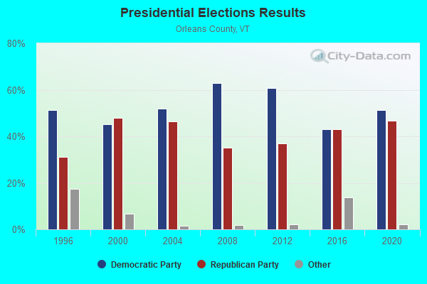
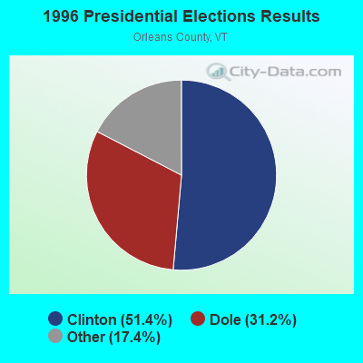
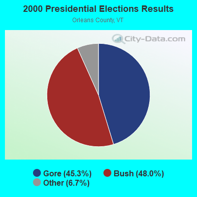


Graphs represent county-level data. Detailed 2008 Election Results
Religion statistics for Westfield, VT (based on Orleans County data)
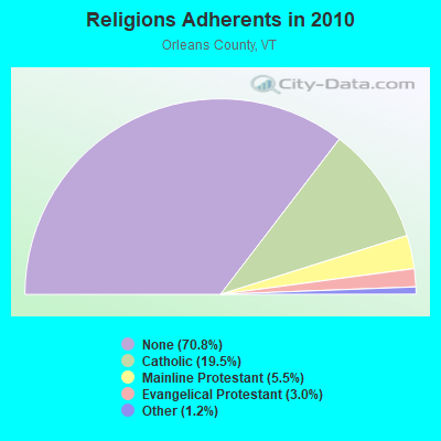
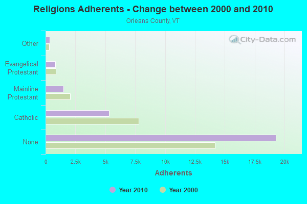
| Religion | Adherents | Congregations |
|---|---|---|
| Catholic | 5,312 | 12 |
| Mainline Protestant | 1,485 | 23 |
| Evangelical Protestant | 822 | 14 |
| Other | 323 | 4 |
| None | 19,289 | - |
Food Environment Statistics:
| Orleans County: | 5.14 / 10,000 pop. |
| Vermont: | 3.84 / 10,000 pop. |
| Here: | 1.10 / 10,000 pop. |
| State: | 1.95 / 10,000 pop. |
| Orleans County: | 6.60 / 10,000 pop. |
| Vermont: | 6.40 / 10,000 pop. |
| Here: | 8.07 / 10,000 pop. |
| Vermont: | 11.52 / 10,000 pop. |
| This county: | 7.0% |
| State: | 6.8% |
| Orleans County: | 24.8% |
| Vermont: | 22.3% |
| Orleans County: | 10.8% |
| Vermont: | 13.3% |
Businesses in Westfield, VT
- U-Haul: 1
Strongest AM radio stations in Westfield:
- WCHP (760 AM; 35 kW; CHAMPLAIN, NY; Owner: CHAMPLAIN RADIO, INC.)
- WDEV (550 AM; 5 kW; WATERBURY, VT; Owner: RADIO VERMONT, INC.)
- WIKE (1490 AM; 1 kW; NEWPORT, VT; Owner: NORTHSTAR MEDIA, INC.)
- WICY (1490 AM; 50 kW; MALONE, NY; Owner: CARTIER COMMUNICATIONS INC.)
- WVMT (620 AM; 5 kW; BURLINGTON, VT; Owner: SISON BROADCASTING, INC.)
- WRKO (680 AM; 50 kW; BOSTON, MA; Owner: ENTERCOM BOSTON LICENSE, LLC)
- WGY (810 AM; 50 kW; SCHENECTADY, NY; Owner: CLEAR CHANNEL BROADCASTING LICENSES, INC.)
- WNNZ (640 AM; 50 kW; WESTFIELD, MA; Owner: CLEAR CHANNEL BROADCASTING LICENSES, INC.)
- WEAV (960 AM; 5 kW; PLATTSBURGH, NY; Owner: CLEAR CHANNEL BROADCASTING LICENSES, INC.)
- WVAA (1390 AM; 5 kW; BURLINGTON, VT; Owner: RADIO VERMONT, KDR, LLC)
- WCRN (830 AM; 50 kW; WORCESTER, MA; Owner: CARTER BROADCASTING CORPORATION)
- WTWK (1070 AM; daytime; 5 kW; PLATTSBURGH, NY; Owner: CHAMPLAIN COMMUNICATIONS CORPORATION)
- WEEI (850 AM; 50 kW; BOSTON, MA; Owner: ENTERCOM BOSTON LICENSE, LLC)
Strongest FM radio stations in Westfield:
- WLKC (103.3 FM; WATERBURY, VT; Owner: RADIO BROADCASTING SERVICES, INC.)
- WEZF (92.9 FM; BURLINGTON, VT; Owner: CAPSTAR TX LIMITED PARTNERSHIP)
- WVPS (107.9 FM; BURLINGTON, VT; Owner: VERMONT PUBLIC RADIO)
- WCVT (101.7 FM; STOWE, VT; Owner: RADIO VERMONT CLASSICS, L.L.C.)
- WNCS (104.7 FM; MONTPELIER, VT; Owner: MONTPELIER BROADCASTING, INC.)
- WGMT (97.7 FM; LYNDON, VT; Owner: VERMONT BROADCAST ASSOCIATES, INC.)
- W243AE (96.5 FM; ORLEANS, VT; Owner: CHRISTIAN MINISTRIES, INC.)
- WPKQ (103.7 FM; NORTH CONWAY, NH; Owner: CITADEL BROADCASTING COMPANY)
- WHOM (94.9 FM; MT. WASHINGTON, NH; Owner: CITADEL BROADCASTING COMPANY)
- WMOO (92.1 FM; DERBY CENTER, VT; Owner: NORTHSTAR MEDIA, INC.)
- WDEV-FM (96.1 FM; WARREN, VT; Owner: RADIO VERMONT, INC.)
- WDOT (95.7 FM; DANVILLE, VT; Owner: MONTPELIER BROADCASTING INC)
- WCEL (91.9 FM; PLATTSBURGH, NY; Owner: WAMC)
- WLFE-FM (102.3 FM; ST. ALBANS, VT; Owner: CHAMPLAIN COMMUNICATIONS CORP.)
- WMTK (106.3 FM; LITTLETON, NH; Owner: VERMONT BROADCAST ASSOCIATES, INC.)
- WGLY-FM (91.5 FM; BOLTON, VT; Owner: CHRISTIAN MINISTRIES, INC.)
Westfield fatal accident list:
Aug 14, 2005 05:21 PM, Th-3, Lat: 44.908150, Lon: -72.416470, Vehicles: 2, Persons: 4, Fatalities: 1, Drunk persons involved: 2
- National Bridge Inventory (NBI) Statistics
- 10Number of bridges
- 66ft / 19.9mTotal length
- $1,340,000Total costs
- 7,190Total average daily traffic
- 541Total average daily truck traffic
- 7,552Total future (year 2028) average daily traffic
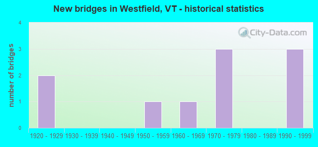
- New bridges - historical statistics
- 21920-1929
- 11950-1959
- 11960-1969
- 31970-1979
- 31990-1999
FCC Registered Broadcast Land Mobile Towers:
2- Westfield Hwy Salt Shed & Garage (Lat: 44.871722 Lon: -72.436222), Call Sign: WLS29,
Assigned Frequencies: 151.070 MHz, Grant Date: 05/05/2021, Expiration Date: 07/31/2031, Registrant: State Of Vermont, 45 State Drive, Watterbury, VT 05671, Phone: (802) 229-0882, Fax: (802) 241-5557, Email:
- Summit Jay Peak (Lat: 44.924500 Lon: -72.525389), Call Sign: WNAE321,
Assigned Frequencies: 159.405 MHz, Grant Date: 06/10/2014, Expiration Date: 09/07/2024, Registrant: State Of Vermont, 45 State Drive, Watterbury, VT 05671, Phone: (802) 229-0882, Fax: (802) 241-5215, Email:
FCC Registered Microwave Towers:
3- STATION, Summit Of Jay Peak (Lat: 44.916417 Lon: -72.512056), Overall height: 9.1 m, Call Sign: WNER865,
Assigned Frequencies: 952.162 MHz, 928.162 MHz, Grant Date: 03/24/1994, Expiration Date: 03/24/1999, Cancellation Date: 04/03/1996, Phone: (802) 828-2274
- STATION, Off Route 242 1 1/2 Mi Nw Jay Peak Ski Area (Lat: 44.924194 Lon: -72.525944), Structure height: 10.7 m, Call Sign: WNTF692,
Assigned Frequencies: 928.368 MHz, 952.368 MHz, Grant Date: 04/27/2011, Expiration Date: 06/13/2021, Cancellation Date: 08/14/2021, Certifier: Richard L Simays, Registrant: Burlington Communications, 4735 Williston Road, Suite 30, Williston, VT 05495, Phone: (802) 862-7092
- Jay Peak, Summit Of Jay Peak (Lat: 44.924500 Lon: -72.525944), Type: Tower, Structure height: 12.2 m, Overall height: 15.2 m, Call Sign: WIS94,
Assigned Frequencies: 6745.00 MHz, 6715.62 MHz, 6152.75 MHz, 6197.24 MHz, 6835.00 MHz, Grant Date: 01/04/2018, Expiration Date: 03/04/2028, Registrant: State Of Vermont, 45 State Drive, Watterbury, VT 05671, Phone: (802) 229-0882, Fax: (802) 241-5557, Email:
FCC Registered Amateur Radio Licenses:
4- Call Sign: N1ORY, Licensee ID: L00261394, Grant Date: 05/19/1999, Expiration Date: 03/23/2003, Cancellation Date: 03/24/2005, Registrant: Matthias J Brittain, Westfield, VT 05874-0160
- Call Sign: N1THG, Grant Date: 09/29/1995, Expiration Date: 10/24/2004, Cancellation Date: 10/25/2006, Registrant: Richard Savino, Rr 1 Box 105a Kennison Rd, Westfield, VT 05874
- Call Sign: W2TYX, Grant Date: 01/17/1995, Expiration Date: 01/17/2005, Cancellation Date: 01/18/2007, Registrant: Paul B Lavallee, Rt 100, Westfield, VT 05874
- Call Sign: KC1FAP, Licensee ID: L02001811, Grant Date: 02/11/2016, Expiration Date: 02/11/2026, Certifier: John E Elliott, Registrant: John E Elliott, 4941 Vt Route 100, Westfield, VT 05874
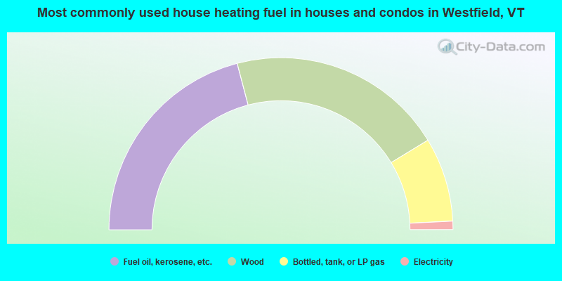
- 41.8%Fuel oil, kerosene, etc.
- 40.8%Wood
- 15.8%Bottled, tank, or LP gas
- 1.6%Electricity
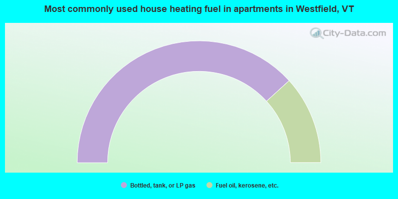
- 76.5%Bottled, tank, or LP gas
- 23.5%Fuel oil, kerosene, etc.
Westfield compared to Vermont state average:
- Unemployed percentage below state average.
- Black race population percentage below state average.
- Hispanic race population percentage significantly below state average.
- Renting percentage below state average.
- Length of stay since moving in significantly above state average.
- Number of rooms per house significantly below state average.
- House age significantly below state average.
- Percentage of population with a bachelor's degree or higher below state average.