Wethersfield, New York
Submit your own pictures of this town and show them to the world
- OSM Map
- Google Map
- MSN Map
Population change since 2000: -0.9%
 |
| Males: 468 | |
| Females: 415 |
| Median resident age: | 39.7 years |
| New York median age: | 40.7 years |
Zip codes: 14066.
| Wethersfield: | $59,526 |
| NY: | $79,557 |
Estimated per capita income in 2022: $31,395 (it was $15,291 in 2000)
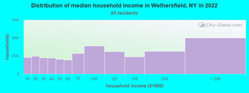
Wethersfield town income, earnings, and wages data
Estimated median house or condo value in 2022: $127,688 (it was $64,500 in 2000)
| Wethersfield: | $127,688 |
| NY: | $400,400 |
Mean prices in 2022: all housing units: $186,586; detached houses: $187,038; townhouses or other attached units: $267,158; in 2-unit structures: $247,178; in 3-to-4-unit structures: $41,140; mobile homes: $75,293
Detailed information about poverty and poor residents in Wethersfield, NY
Compare current foreclosures near Wethersfield, NY:
| Photo | Address | Area | Beds / Baths | Price | Details |
|---|---|---|---|---|---|

|
#1
Sierk Rd
Attica, NY 14011
|
- sq. feet
|
- baths - beds |
$43,900
|
show details |

|
#2
Curriers Rd
Arcade, NY 14009
|
1,464 sq. feet
|
1 baths 3 beds |
show details | |

|
#3
Laurel Dr
Attica, NY 14011
|
1,080 sq. feet
|
1 baths 3 beds |
show details | |

|
#4
Syler Rd
Varysburg, NY 14167
|
1,120 sq. feet
|
1 baths 1 beds |
show details | |

|
#5
Buckland Ave
Perry, NY 14530
|
2,100 sq. feet
|
1 baths 3 beds |
show details | |

|
#6
Woods Rd
East Aurora, NY 14052
|
1,645 sq. feet
|
1 baths 3 beds |
show details | |

|
#7
School St
Wyoming, NY 14591
|
1,435 sq. feet
|
1 baths 3 beds |
show details | |

|
#8
S Protection Rd
Holland, NY 14080
|
1,152 sq. feet
|
1 baths 2 beds |
show details | |

|
#9
Osmun Rd
Farmersville Station, NY 14060
|
720 sq. feet
|
2 baths 4 beds |
show details | |

|
#10
Savage Rd
Chaffee, NY 14030
|
1,086 sq. feet
|
1 baths 3 beds |
show details |
| Photo | Address | Area | Beds / Baths | Price | Details |
|---|---|---|---|---|---|

|
#11
Main Ter
Perry, NY 14530
|
1,560 sq. feet
|
1 baths 3 beds |
show details | |

|
#12
Timelessview Dr
Chaffee, NY 14030
|
1,410 sq. feet
|
2 baths 3 beds |
show details | |

|
#13
Hunters Creek Rd
South Wales, NY 14139
|
1,438 sq. feet
|
1 baths 3 beds |
show details | |

|
#14
Maple St
Arcade, NY 14009
|
2,240 sq. feet
|
2 baths 5 beds |
show details | |

|
#15
Buckland Ave
Perry, NY 14530
|
2,060 sq. feet
|
2 baths 4 beds |
show details | |

|
#16
Freedom Rd
Freedom, NY 14065
|
1,749 sq. feet
|
1 baths 4 beds |
show details | |

|
#17
Middle Reservation Rd
Perry, NY 14530
|
3,494 sq. feet
|
1 baths 3 beds |
show details | |

|
#18
Hughes Rd
Arcade, NY 14009
|
1,848 sq. feet
|
2 baths 4 beds |
show details | |

|
#19
Friedman Rd
Attica, NY 14011
|
1,512 sq. feet
|
2 baths 2 beds |
show details | |

|
#20
School St
Attica, NY 14011
|
2,105 sq. feet
|
2 baths 4 beds |
show details |
| Photo | Address | Area | Beds / Baths | Price | Details |
|---|---|---|---|---|---|

|
#21
Orchard St
Silver Springs, NY 14550
|
1,356 sq. feet
|
1 baths 2 beds |
show details | |

|
#22
Brown Schoolhouse Rd
Freedom, NY 14065
|
1,664 sq. feet
|
2 baths 3 beds |
show details | |

|
#23
Route 98
Farmersville Station, NY 14060
|
- sq. feet
|
- baths - beds |
show details | |

|
#24
Meadow Ln
Delevan, NY 14042
|
- sq. feet
|
- baths - beds |
show details | |

|
#25
Woodworth Ln
Nunda, NY 14517
|
- sq. feet
|
- baths - beds |
show details | |

|
#26
Pioneer Ln
Delevan, NY 14042
|
- sq. feet
|
- baths - beds |
show details | |

|
#27
Route 98
Farmersville Station, NY 14060
|
- sq. feet
|
- baths - beds |
show details | |

|
#28
Westover Rd
Yorkshire, NY 14173
|
- sq. feet
|
- baths - beds |
show details | |

|
#29
Old Olean Rd
Yorkshire, NY 14173
|
- sq. feet
|
- baths - beds |
show details | |

|
#30
Southview Dr
Arcade, NY 14009
|
- sq. feet
|
- baths - beds |
show details |
| Photo | Address | Area | Beds / Baths | Price | Details |
|---|---|---|---|---|---|

|
#31
Old Olean Rd
Yorkshire, NY 14173
|
- sq. feet
|
- baths - beds |
show details | |

|
#32
Winterview Dr
Arcade, NY 14009
|
- sq. feet
|
- baths - beds |
show details | |

|
#33
Sunset Ln
Arcade, NY 14009
|
- sq. feet
|
- baths - beds |
show details | |

|
#34
Main St
Wyoming, NY 14591
|
- sq. feet
|
- baths - beds |
show details | |

|
#35
Gouinlock St
Warsaw, NY 14569
|
- sq. feet
|
- baths - beds |
show details | |

|
#36
Phillippi Rd
Freedom, NY 14065
|
- sq. feet
|
- baths - beds |
show details | |

|
#37
Route 98
Freedom, NY 14065
|
- sq. feet
|
- baths - beds |
show details | |

|
#38
Mutton Hollow Rd
Freedom, NY 14065
|
- sq. feet
|
- baths - beds |
show details | |

|
#39
Sparks Rd
Freedom, NY 14065
|
1,280 sq. feet
|
- baths - beds |
show details | |

|
#40
Creekside Ln Apt 202
Arcade, NY 14009
|
- sq. feet
|
- baths - beds |
show details |
| Photo | Address | Area | Beds / Baths | Price | Details |
|---|---|---|---|---|---|

|
#41
Tuna St
Perry, NY 14530
|
- sq. feet
|
- baths - beds |
show details | |

|
#42
Main St # 2
Strykersville, NY 14145
|
- sq. feet
|
- baths - beds |
show details | |

|
#43
State Route 436
Nunda, NY 14517
|
- sq. feet
|
- baths - beds |
show details | |

|
#44
Weaver Rd
Delevan, NY 14042
|
- sq. feet
|
- baths - beds |
show details | |

|
#45
N Main St
Delevan, NY 14042
|
- sq. feet
|
- baths - beds |
show details | |

|
#46
Michigan Rd
Arcade, NY 14009
|
- sq. feet
|
- baths - beds |
show details | |

|
Check over 1 million property listings on Foreclosure.com!
|
browse all offers | |||

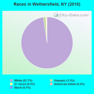
- 86397.7%White alone
- 131.5%Hispanic
- 40.5%Two or more races
- 20.2%American Indian alone
- 10.1%Black alone
Races in Wethersfield detailed stats: ancestries, foreign born residents, place of birth
 Recent articles from our blog. Our writers, many of them Ph.D. graduates or candidates, create easy-to-read articles on a wide variety of topics.
Ancestries: German (35.7%), Polish (14.1%), Irish (13.4%), Italian (12.0%), United States (11.7%), English (8.9%).
Current Local Time: EST time zone
Land area: 35.8 square miles.
Population density: 25 people per square mile (very low).
4 residents are foreign born
| This town: | 0.4% |
| New York: | 20.4% |
| Wethersfield town: | 1.9% ($1,221) |
| New York: | 1.9% ($2,847) |
Nearest city with pop. 50,000+: Cheektowaga, NY  (32.1 miles , pop. 79,988).
Nearest city with pop. 200,000+: Buffalo, NY (35.7 miles , pop. 292,648).
Nearest city with pop. 1,000,000+: Philadelphia, PA (243.8 miles , pop. 1,517,550).
Nearest cities:
), ), ), ), )Latitude: 42.65 N, Longitude: 78.24 W
Area code commonly used in this area: 585
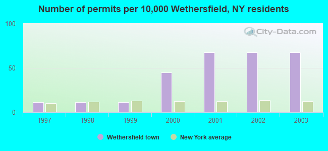
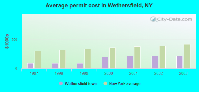
Single-family new house construction building permits:
- 2003: 6 buildings, average cost: $87,000
- 2002: 6 buildings, average cost: $87,000
- 2001: 6 buildings, average cost: $87,000
- 2000: 4 buildings, average cost: $77,500
- 1999: 1 building, cost: $36,000
- 1998: 1 building, cost: $36,000
- 1997: 1 building, cost: $36,000
| Here: | 5.0% |
| New York: | 4.4% |
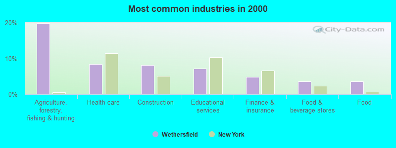
- Agriculture, forestry, fishing & hunting (19.8%)
- Health care (8.4%)
- Construction (8.1%)
- Educational services (7.1%)
- Finance & insurance (4.8%)
- Food & beverage stores (3.6%)
- Food (3.6%)
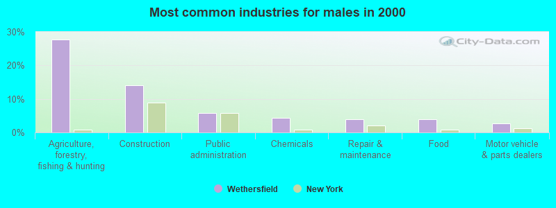
- Agriculture, forestry, fishing & hunting (27.6%)
- Construction (14.0%)
- Public administration (5.7%)
- Chemicals (4.4%)
- Repair & maintenance (3.9%)
- Food (3.9%)
- Motor vehicle & parts dealers (2.6%)
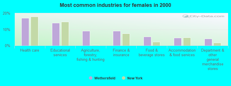
- Health care (17.0%)
- Educational services (13.9%)
- Agriculture, forestry, fishing & hunting (9.1%)
- Finance & insurance (9.1%)
- Food & beverage stores (5.5%)
- Accommodation & food services (4.8%)
- Department & other general merchandise stores (4.2%)
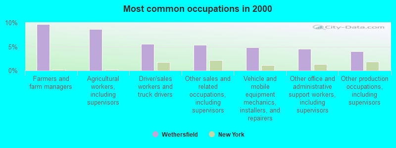
- Farmers and farm managers (9.7%)
- Agricultural workers, including supervisors (8.7%)
- Driver/sales workers and truck drivers (5.6%)
- Other sales and related occupations, including supervisors (5.3%)
- Vehicle and mobile equipment mechanics, installers, and repairers (4.8%)
- Other office and administrative support workers, including supervisors (4.6%)
- Other production occupations, including supervisors (4.1%)
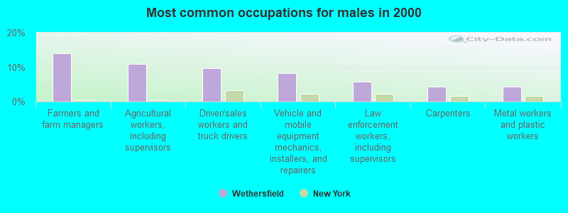
- Farmers and farm managers (14.0%)
- Agricultural workers, including supervisors (11.0%)
- Driver/sales workers and truck drivers (9.6%)
- Vehicle and mobile equipment mechanics, installers, and repairers (8.3%)
- Law enforcement workers, including supervisors (5.7%)
- Carpenters (4.4%)
- Metal workers and plastic workers (4.4%)
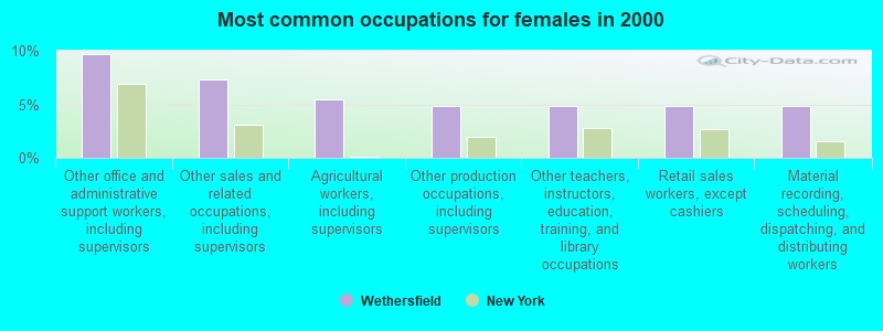
- Other office and administrative support workers, including supervisors (9.7%)
- Other sales and related occupations, including supervisors (7.3%)
- Agricultural workers, including supervisors (5.5%)
- Other production occupations, including supervisors (4.8%)
- Other teachers, instructors, education, training, and library occupations (4.8%)
- Retail sales workers, except cashiers (4.8%)
- Material recording, scheduling, dispatching, and distributing workers (4.8%)
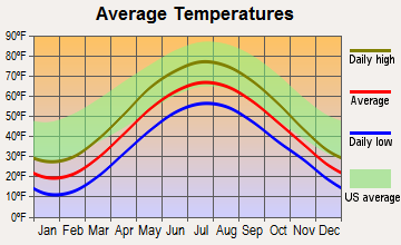
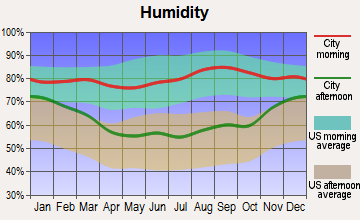
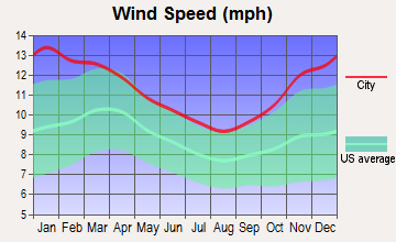
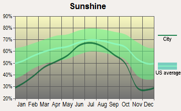
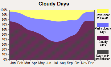
Average climate in Wethersfield, New York
Based on data reported by over 4,000 weather stations

Tornado activity:
Wethersfield-area historical tornado activity is slightly below New York state average. It is 69% smaller than the overall U.S. average.
On 6/20/1969, a category F3 (max. wind speeds 158-206 mph) tornado 24.8 miles away from the Wethersfield town center caused between $500,000 and $5,000,000 in damages.
On 7/24/1967, a category F3 tornado 25.3 miles away from the town center caused between $5000 and $50,000 in damages.
Earthquake activity:
Wethersfield-area historical earthquake activity is significantly above New York state average. It is 66% smaller than the overall U.S. average.On 9/25/1998 at 19:52:52, a magnitude 5.2 (4.8 MB, 4.3 MS, 5.2 LG, 4.5 MW, Depth: 3.1 mi, Class: Moderate, Intensity: VI - VII) earthquake occurred 136.9 miles away from Wethersfield center
On 10/7/1983 at 10:18:46, a magnitude 5.3 (5.1 MB, 5.3 LG, 5.1 ML) earthquake occurred 215.6 miles away from Wethersfield center
On 1/31/1986 at 16:46:43, a magnitude 5.0 (5.0 MB) earthquake occurred 166.6 miles away from Wethersfield center
On 8/23/2011 at 17:51:04, a magnitude 5.8 (5.8 MW, Depth: 3.7 mi) earthquake occurred 328.4 miles away from the city center
On 4/20/2002 at 10:50:47, a magnitude 5.3 (5.3 ML, Depth: 3.0 mi) earthquake occurred 261.2 miles away from Wethersfield center
On 4/20/2002 at 10:50:47, a magnitude 5.2 (5.2 MB, 4.2 MS, 5.2 MW, 5.0 MW) earthquake occurred 259.5 miles away from the city center
Magnitude types: regional Lg-wave magnitude (LG), body-wave magnitude (MB), local magnitude (ML), surface-wave magnitude (MS), moment magnitude (MW)
Natural disasters:
The number of natural disasters in Wyoming County (20) is greater than the US average (15).Major Disasters (Presidential) Declared: 11
Emergencies Declared: 9
Causes of natural disasters: Storms: 7, Floods: 6, Snowstorms: 4, Winter Storms: 4, Tornadoes: 3, Hurricanes: 2, Blizzard: 1, Ice Storm: 1, Power Outage: 1, Tropical Storm: 1, Wind: 1, Other: 2 (Note: some incidents may be assigned to more than one category).
Hospitals and medical centers near Wethersfield:
- WYOMING CO DOH CHHA (Home Health Center, about 7 miles away; SILVER SPRINGS, NY)
- EAST SIDE NURSING HOME (Nursing Home, about 9 miles away; WARSAW, NY)
- MANOR OAK SKILLED NURSING FACILITIES WARSAW (Nursing Home, about 9 miles away; WARSAW, NY)
- WYOMING COUNTY COMMUNITY HOSPITAL Acute Care Hospitals (about 9 miles away; WARSAW, NY)
- FINGER LAKES DDSO (Hospital, about 12 miles away; PERRY, NY)
- FINGER LAKES DDSO (Hospital, about 16 miles away; NUNDA, NY)
Colleges/universities with over 2000 students nearest to Wethersfield:
- SUNY College at Geneseo (about 24 miles; Geneseo, NY; Full-time enrollment: 5,520)
- Genesee Community College (about 26 miles; Batavia, NY; FT enrollment: 4,290)
- Bryant & Stratton College-Online (about 29 miles; Orchard Park, NY; FT enrollment: 2,212)
- SUNY College of Technology at Alfred (about 36 miles; Alfred, NY; FT enrollment: 3,483)
- Daemen College (about 36 miles; Amherst, NY; FT enrollment: 2,365)
- Alfred University (about 36 miles; Alfred, NY; FT enrollment: 2,411)
- Erie Community College (about 37 miles; Buffalo, NY; FT enrollment: 11,035)
Points of interest:
Notable locations in Wethersfield: Eastman Corners (A), Poplar Tree Corners (B), Camp Weona (C). Display/hide their locations on the map
Church in Wethersfield: New Beginnings Fellowship Church (A). Display/hide its location on the map
Cemeteries: Sheppard Cemetery (1), Hermitage Cemetery (2), Union Park Cemetery (3), Wethersfield Cemetery (4). Display/hide their locations on the map
Lake: Faun Lake (A). Display/hide its location on the map
Creek: Engine Creek (A). Display/hide its location on the map
Birthplace of: Don Bosseler - Football player.
| This town: | 2.6 people |
| New York: | 2.6 people |
| This town: | 75.1% |
| Whole state: | 63.5% |
| This town: | 9.6% |
| Whole state: | 6.8% |
Likely homosexual households (counted as self-reported same-sex unmarried-partner households)
- Lesbian couples: 0.0% of all households
- Gay men: 0.6% of all households
| This town: | 12.4% |
| Whole state: | 14.6% |
| This town: | 3.8% |
| Whole state: | 7.4% |
For population 15 years and over in Wethersfield:
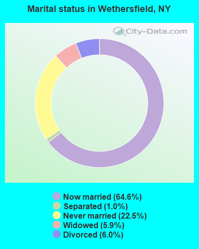
- Never married: 22.5%
- Now married: 64.6%
- Separated: 1.0%
- Widowed: 5.9%
- Divorced: 6.0%
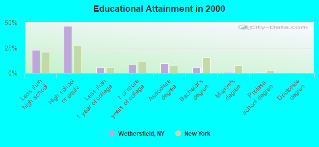
For population 25 years and over in Wethersfield:
- High school or higher: 77.2%
- Bachelor's degree or higher: 7.0%
- Graduate or professional degree: 1.6%
- Unemployed: 6.2%
- Mean travel time to work (commute): 27.5 minutes
| Here: | 7.9 |
| New York average: | 14.2 |
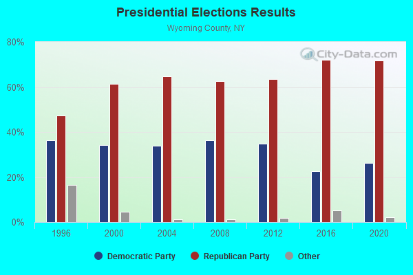
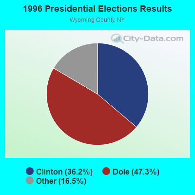

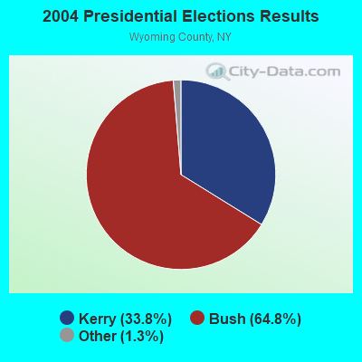
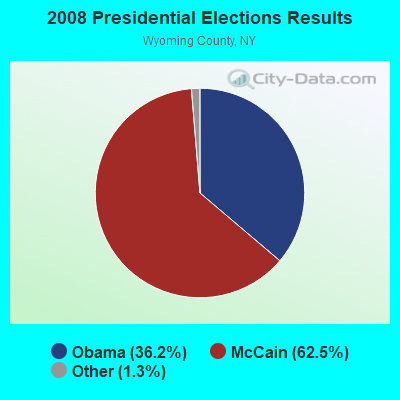
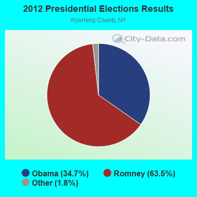
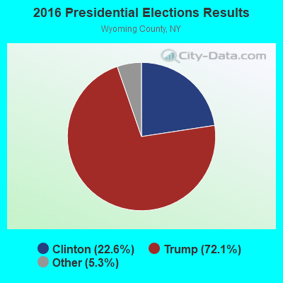
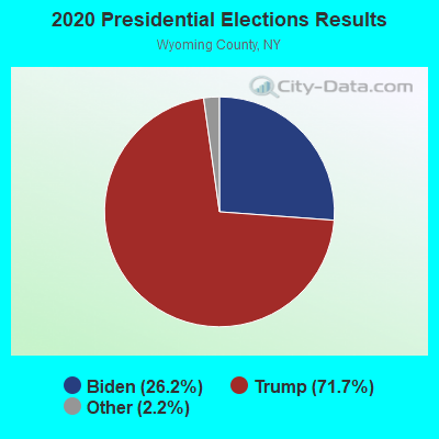
Graphs represent county-level data. Detailed 2008 Election Results
Religion statistics for Wethersfield, NY (based on Wyoming County data)
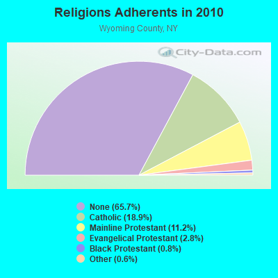
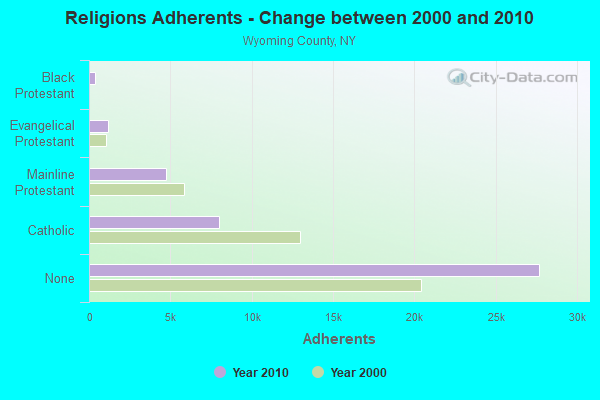
| Religion | Adherents | Congregations |
|---|---|---|
| Catholic | 7,968 | 5 |
| Mainline Protestant | 4,716 | 30 |
| Evangelical Protestant | 1,168 | 24 |
| Black Protestant | 354 | 1 |
| Other | 249 | 2 |
| None | 27,700 | - |
Food Environment Statistics:
| This county: | 2.15 / 10,000 pop. |
| New York: | 4.13 / 10,000 pop. |
| Wyoming County: | 0.96 / 10,000 pop. |
| New York: | 0.92 / 10,000 pop. |
| This county: | 4.54 / 10,000 pop. |
| New York: | 1.68 / 10,000 pop. |
| Here: | 6.93 / 10,000 pop. |
| New York: | 8.82 / 10,000 pop. |
| Here: | 8.5% |
| New York: | 8.2% |
| Wyoming County: | 26.3% |
| New York: | 23.8% |
| Wyoming County: | 13.6% |
| State: | 15.6% |
Strongest AM radio stations in Wethersfield:
- WCJW (1140 AM; daytime; 2 kW; WARSAW, NY; Owner: LLOYD LANE, INCORPORATED)
- WWKB (1520 AM; 50 kW; BUFFALO, NY; Owner: ENTERCOM BUFFALO LICENSE, LLC)
- WHAM (1180 AM; 50 kW; ROCHESTER, NY; Owner: CITICASTERS LICENSES, L.P.)
- WGR (550 AM; 5 kW; BUFFALO, NY; Owner: ENTERCOM BUFFALO LICENSE, LLC)
- WXRL (1300 AM; 5 kW; LANCASTER, NY; Owner: DOME BROADCASTING, INC.)
- WNED (970 AM; 5 kW; BUFFALO, NY)
- WTOR (770 AM; daytime; 9 kW; YOUNGSTOWN, NY; Owner: BIRACH BROADCASTING CORPORATION)
- WHLD (1270 AM; 5 kW; NIAGARA FALLS, NY; Owner: CITADEL BROADCASTING COMPANY)
- WBEN (930 AM; 5 kW; BUFFALO, NY; Owner: ENTERCOM BUFFALO LICENSE, LLC)
- WHHO (1320 AM; 5 kW; HORNELL, NY; Owner: BILBAT RADIO, INC.)
- WABH (1380 AM; 10 kW; BATH, NY)
- WYSL (1040 AM; 2 kW; AVON, NY; Owner: RADIO LIVINGSTON, LTD)
- WLGZ (990 AM; 5 kW; ROCHESTER, NY; Owner: KIMTRON, INC.)
Strongest FM radio stations in Wethersfield:
- WNSA (107.7 FM; WETHERSFIELD TWNSHP, NY; Owner: ADELPHIA COMMUNICATIONS CORPORATION, DEBTOR-IN-POSSESSION)
- WTSS (102.5 FM; BUFFALO, NY; Owner: ENTERCOM BUFFALO LICENSE, LLC)
- WCOU (88.3 FM; WARSAW, NY; Owner: FAMILY LIFE MINISTRIES, INC.)
- WLOF (101.7 FM; ATTICA, NY; Owner: HOLY FAMILY COMMUNICATIONS, INC.)
- WBUF (92.9 FM; BUFFALO, NY; Owner: INFINITY RADIO OPERATIONS INC.)
- WNED-FM (94.5 FM; BUFFALO, NY; Owner: WESTERN NEW YORK PUBLIC B/C ASSOC.)
- WDCX (99.5 FM; BUFFALO, NY; Owner: KIMTRON, INC.)
- WCIY (88.9 FM; CANANDAIGUA, NY; Owner: FAMILY LIFE MINISTRIES, INC.)
- WDNY-FM (93.9 FM; DANSVILLE, NY; Owner: MILLER MEDIA INC.)
- WFXF (107.3 FM; SOUTH BRISTOL TOWNSH, NY; Owner: CITICASTERS LICENSES, L.P.)
- WNVE (95.1 FM; HONEOYE FALLS, NY; Owner: CITICASTERS LICENSES, L.P.)
- WGRF (96.9 FM; BUFFALO, NY; Owner: CITADEL BROADCASTING COMPANY)
- W201CY (88.1 FM; DANSVILLE, NY; Owner: MARS HILL BROADCASTING CO., INC.)
- WZKZ (101.9 FM; ALFRED, NY; Owner: PEMBROOK PINES ELMIRA, LTD.)
- W246AP (97.1 FM; DANSVILLE, NY; Owner: CALVARY CHAPEL OF THE FINGER LAKES)
- W282AC (104.3 FM; DANSVILLE, NY; Owner: FAMILY LIFE MINISTRIES, INC.)
- WFBF (89.9 FM; BUFFALO, NY; Owner: FAMILY STATIONS, INC.)
- WJSL (90.3 FM; HOUGHTON, NY; Owner: WXXI PUBLIC BROADCASTING COUNCIL)
TV broadcast stations around Wethersfield:
- WNYO-TV (Channel 49; BUFFALO, NY; Owner: NEW YORK TELEVISION, INC.)
- WGRZ-TV (Channel 2; BUFFALO, NY; Owner: MULTIMEDIA ENTERTAINMENT, INC.)
- WKBW-TV (Channel 7; BUFFALO, NY; Owner: WKBW-TV LICENSE, INC.)
- WIVB-TV (Channel 4; BUFFALO, NY; Owner: WIVB BROADCASTING, LLC)
- WPXJ-TV (Channel 51; BATAVIA, NY; Owner: PAXSON BUFFALO LICENSE, INC.)
- WNGS (Channel 67; SPRINGVILLE, NY; Owner: CAROLINE K. POWLEY D/B/A UNICORN/SPRINGVILLE)
- WNED-TV (Channel 17; BUFFALO, NY; Owner: WESTERN NY PUBLIC BROADCASTING ASSOC.)
- WUTV (Channel 29; BUFFALO, NY; Owner: WUTV LICENSEE, LLC)
- WNLO (Channel 23; BUFFALO, NY; Owner: WIVB BROADCASTING, LLC)
- National Bridge Inventory (NBI) Statistics
- 4Number of bridges
- 13ft / 4.2mTotal length
- $3,013,000Total costs
- 3,597Total average daily traffic
- 505Total average daily truck traffic
- 5,036Total future (year 2036) average daily traffic
FCC Registered Antenna Towers:
7- James H Reger, Wethersfield Rd. 0.4mi Of Poplar Tree Rd. (Lat: 42.685167 Lon: -78.243000), Type: 121.9, Overall height: 121.9 m, Registrant: Mintz, Levin, Cohn, Ferris, Glovsky And Popeo, P.C., Rfox@mintz.Com, , Washi-ngton, Phone: (202) 434-7483
- James H Reger, Wethersfield Rd. 0.4mi Of Poplar Tree Rd. (Lat: 42.685167 Lon: -78.243000), Type: 121.9, Overall height: 121.9 m, Registrant: Mintz, Levin, Cohn, Ferris, Glovsky And Popeo, P.C., Rfox@mintz.Com, , Washi-ngton, Phone: (202) 434-7483
- Michael A Saia, Wethersfield Rd. 0.5 Mi Of Poplar Tree Rd. (Lat: 42.685500 Lon: -78.240556), Type: 121.9, Structure height: 36121 m, Overall height: 121.9 m, Registrant: Saia Communications, Mike.Saia@saiacomm.Com, , Buffa-lo, Phone: (716) 892-2900
- Michael A Saia, Wethersfield Rd. 0.5 Mi Of Poplar Tree Rd. (Lat: 42.685500 Lon: -78.240556), Type: 121.9, Structure height: 36121 m, Overall height: 121.9 m, Registrant: Saia Communications, Mike.Saia@saiacomm.Com, , Buffa-lo, Phone: (716) 892-2900
- Michael A Saia, 3609 Wethersfield Rd, Wethersfield, Ny (Lat: 42.685194 Lon: -78.242917), Type: 91.4, Structure height: 36121 m, Overall height: 91.4 m, Registrant: Saia Communications, Mike.Saia@saiacomm.Com, , 8922900 Buffa-lo, Phone: (716) 892-2900
- Michael A Saia, 3609 Wethersfield Rd, Wethersfield, Ny (Lat: 42.685194 Lon: -78.242917), Type: 91.4, Structure height: 36121 m, Overall height: 91.4 m, Registrant: Saia Communications, Mike.Saia@saiacomm.Com, , 8922900 Buffa-lo, Phone: (716) 892-2900
- Michael A Saia, 3609 Wethersfield Rd, Wethersfield, Ny (Lat: 42.685194 Lon: -78.242917), Type: 91.4, Structure height: 36121 m, Overall height: 91.4 m, Registrant: Saia Communications, Mike.Saia@saiacomm.Com, , 8922900 Buffa-lo, Phone: (716) 892-2900
FCC Registered Broadcast Land Mobile Towers:
5- Union Corners & Poplar Tree Rd (Lat: 42.678667 Lon: -78.249722), Type: Tower, Structure height: 24.4 m, Overall height: 33.5 m, Call Sign: KLS641,
Assigned Frequencies: 45.4400 MHz, Grant Date: 12/17/2022, Expiration Date: 02/23/2033, Registrant: Nys Div. Of Homeland Security And Emergency Services, 1220 Washington Ave, Bldg. 7a, Ste 710, State Office Campus, Albany, NY 12242, Phone: (518) 322-4911, Fax: (518) 322-4975, Email:
- 3 Mi N (Lat: 42.672278 Lon: -78.255278), Type: Gtower, Structure height: 49 m, Call Sign: KFB918,
Assigned Frequencies: 159.225 MHz, 159.225 MHz, 159.465 MHz, 159.465 MHz, Grant Date: 11/22/2022, Expiration Date: 02/17/2033, Registrant: New York State Department Of Environmental Conservation Office For Pub, 18009 Game Farm Rd, Dexter, NY 13634, Phone: (315) 639-3053, Fax: (315) 639-6553, Email:
- 3 Mi N (Lat: 42.672278 Lon: -78.255278), Type: Gtower, Structure height: 37 m, Call Sign: WNGU465,
Assigned Frequencies: 159.435 MHz, Grant Date: 06/29/2021, Expiration Date: 08/27/2031, Registrant: Ronmental Conservation Office For Pub, 18009 Game Farm Rd, Dexter, NY 13634, Phone: (315) 639-3053, Fax: (315) 639-6553, Email:
- 3 Mi N (Lat: 42.672278 Lon: -78.255278), Type: Gtower, Structure height: 49 m, Call Sign: KSZ715,
Assigned Frequencies: 155.505 MHz, 154.695 MHz, 155.565 MHz, 155.475 MHz, Grant Date: 02/04/2015, Expiration Date: 03/31/2025, Certifier: Carl W Carlton Jr, Registrant: New York State Police, 1220 Washington Ave, Bldg 22, Albany, NY 12226-2252, Phone: (518) 457-9466, Fax: (518) 457-5676, Email:
- WETHERSFIELD, Lat: 42.672278 Lon: -78.255278, Call Sign: WPXV525,
Assigned Frequencies: 151.310 MHz, 151.430 MHz, 151.415 MHz, Grant Date: 03/28/2023, Expiration Date: 06/17/2033, Certifier: John Kenty, Registrant: New York State Department Of Environmental Conservation Office For Pub, 17893 Game Farm Rd, Dexter, NY 13634, Phone: (315) 639-3053, Fax: (315) 639-6553, Email:
FCC Registered Microwave Towers:
3- STATION, Wethersfield Rd 0.4 Mi E Of Poplar Tree Rd (Lat: 42.685333 Lon: -78.242500), Overall height: 33.5 m, Call Sign: WSP69,
Assigned Frequencies: 2184.00 MHz, Grant Date: 01/28/2000, Expiration Date: 02/16/2010, Cancellation Date: 04/24/2010, Phone: (716) 786-8193
- WETHERSFIELD, Wethersfield Rd. 0.5 Mi Of Poplar Tree Rd. (Lat: 42.685500 Lon: -78.240556), Type: Ltower, Structure height: 121.9 m, Call Sign: WQYP534,
Assigned Frequencies: 11245.0 MHz, 11285.0 MHz, 11325.0 MHz, 11215.0 MHz, 11405.0 MHz, Grant Date: 11/30/2016, Expiration Date: 11/30/2026, Certifier: Anthony Santoro, Registrant: Saia Communications, 100 Stradtman Street, Buffalo, NY 14206, Phone: (716) 892-2900, Fax: (716) 892-2983, Email:
- WETHERSFIELD, 2 Miles Wsw Of (Lat: 42.623111 Lon: -78.287500), Overall height: 30.5 m, Call Sign: KEA26,
Assigned Frequencies: 6049.00 MHz, Grant Date: 02/01/1989, Expiration Date: 03/01/2000, Cancellation Date: 06/04/2000, Registrant: Emi Communications Corporation, Syracuse, NY 13221
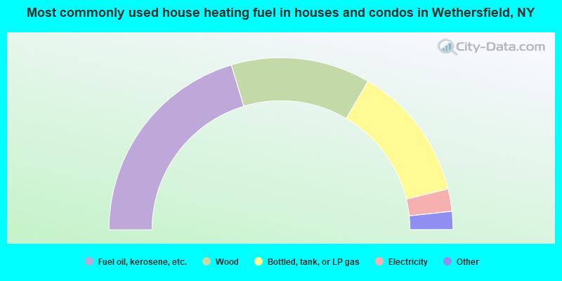
- 40.7%Fuel oil, kerosene, etc.
- 26.2%Wood
- 25.5%Bottled, tank, or LP gas
- 4.2%Electricity
- 1.5%Utility gas
- 1.1%Other fuel
- 0.8%Coal or coke
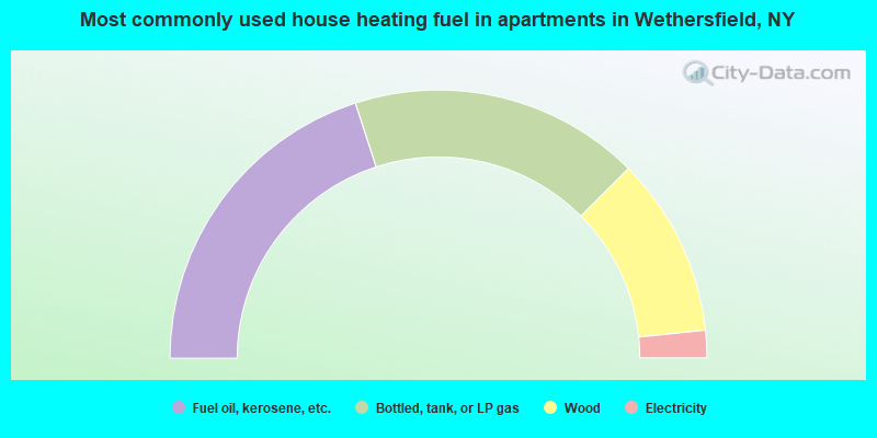
- 40.0%Fuel oil, kerosene, etc.
- 35.0%Bottled, tank, or LP gas
- 21.7%Wood
- 3.3%Electricity
Wethersfield compared to New York state average:
- Median house value significantly below state average.
- Unemployed percentage below state average.
- Black race population percentage significantly below state average.
- Hispanic race population percentage significantly below state average.
- Foreign-born population percentage significantly below state average.
- Renting percentage below state average.
- Length of stay since moving in significantly above state average.
- Number of rooms per house significantly below state average.
- House age significantly below state average.
- Number of college students below state average.
- Percentage of population with a bachelor's degree or higher significantly below state average.