Whiteside, Tennessee
Submit your own pictures of this place and show them to the world
- OSM Map
- General Map
- Google Map
- MSN Map

| Males: 818 | |
| Females: 818 |
| Median resident age: | 41.8 years |
| Tennessee median age: | 35.9 years |
Zip code: 37340
| Whiteside: | $59,713 |
| TN: | $65,254 |
Estimated per capita income in 2022: $40,627 (it was $22,344 in 2000)
Whiteside CCD income, earnings, and wages data
Estimated median house or condo value in 2022: $139,046 (it was $49,400 in 2000)
| Whiteside: | $139,046 |
| TN: | $284,800 |
Mean prices in 2022: all housing units: $256,222; detached houses: $285,258; townhouses or other attached units: $314,201; mobile homes: $80,632
Detailed information about poverty and poor residents in Whiteside, TN
Compare current foreclosures near Whiteside, TN:
| Photo | Address | Area | Beds / Baths | Price | Details |
|---|---|---|---|---|---|

|
#1
Cuscowilla Trl
Chattanooga, TN 37415
|
1,608 sq. feet
|
2 baths 3 beds |
show details | |

|
#2
Hass Rd
Jasper, TN 37347
|
1,680 sq. feet
|
2 baths 3 beds |
show details | |

|
#3
Wiley Ave
Chattanooga, TN 37412
|
2,345 sq. feet
|
2 baths 4 beds |
show details | |

|
#4
Gadd Rd
Chattanooga, TN 37415
|
1,066 sq. feet
|
1 baths 3 beds |
show details | |

|
#5
Page Rd
Rossville, GA 30741
|
1,626 sq. feet
|
2 baths 3 beds |
show details | |

|
#6
Daisy St
Chattanooga, TN 37406
|
- sq. feet
|
- baths - beds |
$16,050
|
show details |

|
#7
Creek Rd
Wildwood, GA 30757
|
1,560 sq. feet
|
2 baths 3 beds |
show details | |

|
#8
Crescent Ave
Chickamauga, GA 30707
|
1,272 sq. feet
|
1 baths - beds |
show details | |

|
#9
Wilder Rd
Chickamauga, GA 30707
|
1,152 sq. feet
|
2 baths - beds |
show details | |

|
#10
Highway 150
Sequatchie, TN 37374
|
1,344 sq. feet
|
1 baths - beds |
show details |
| Photo | Address | Area | Beds / Baths | Price | Details |
|---|---|---|---|---|---|

|
#11
Boss Rd
Chickamauga, GA 30707
|
1,196 sq. feet
|
1 baths - beds |
show details | |

|
#12
Alvin York Hwy
Whitwell, TN 37397
|
960 sq. feet
|
1 baths - beds |
show details | |

|
#13
Highway 301
Trenton, GA 30752
|
1,178 sq. feet
|
1 baths - beds |
show details | |

|
#14
Marion Ave
South Pittsburg, TN 37380
|
1,768 sq. feet
|
1 baths - beds |
show details | |

|
#15
Fricks Ln
Rossville, GA 30741
|
1,400 sq. feet
|
1 baths - beds |
show details | |

|
#16
Delores Dr
Fort Oglethorpe, GA 30742
|
1,224 sq. feet
|
1 baths - beds |
show details | |

|
#17
Cross St
Rossville, GA 30741
|
1,000 sq. feet
|
1 baths - beds |
show details | |

|
#18
Leinbach Rd
Rossville, GA 30741
|
1,348 sq. feet
|
1 baths - beds |
show details | |

|
#19
Wolf St
Rossville, GA 30741
|
1,117 sq. feet
|
2 baths - beds |
show details | |

|
#20
S Stovall St
Fort Oglethorpe, GA 30742
|
1,068 sq. feet
|
1 baths - beds |
show details |
| Photo | Address | Area | Beds / Baths | Price | Details |
|---|---|---|---|---|---|

|
#21
Cloud Springs Rd
Rossville, GA 30741
|
912 sq. feet
|
1 baths - beds |
show details | |

|
#22
Lynngrove Dr
Rossville, GA 30741
|
1,334 sq. feet
|
1 baths - beds |
show details | |

|
#23
W 9th St
Chickamauga, GA 30707
|
1,200 sq. feet
|
1 baths - beds |
show details | |

|
#24
Lakeview Dr
Rossville, GA 30741
|
1,600 sq. feet
|
1 baths - beds |
show details | |

|
#25
E Georgia Ave
Whitwell, TN 37397
|
1,923 sq. feet
|
1 baths - beds |
show details | |

|
#26
Old Lafayette Rd
Fort Oglethorpe, GA 30742
|
1,353 sq. feet
|
2 baths - beds |
show details | |

|
#27
Alvin York Hwy
Whitwell, TN 37397
|
1,032 sq. feet
|
1 baths - beds |
show details | |

|
#28
Pegram Cir
Fort Oglethorpe, GA 30742
|
1,600 sq. feet
|
1 baths - beds |
show details | |

|
#29
Battlewood Dr
Fort Oglethorpe, GA 30742
|
1,404 sq. feet
|
2 baths - beds |
show details | |

|
#30
Ridgeland Rd
Rossville, GA 30741
|
825 sq. feet
|
1 baths - beds |
show details |
| Photo | Address | Area | Beds / Baths | Price | Details |
|---|---|---|---|---|---|

|
#31
Rolling Dr
Rossville, GA 30741
|
1,179 sq. feet
|
1 baths - beds |
show details | |

|
#32
N Marble Top Rd
Chickamauga, GA 30707
|
1,870 sq. feet
|
2 baths - beds |
show details | |

|
#33
Laurel Ave
South Pittsburg, TN 37380
|
1,025 sq. feet
|
1 baths - beds |
show details | |

|
#34
Sweet Birch Dr
Rossville, GA 30741
|
1,681 sq. feet
|
2 baths - beds |
show details | |

|
#35
Hames Rd
Chickamauga, GA 30707
|
1,323 sq. feet
|
2 baths - beds |
show details | |

|
#36
Dee Vue Ln
Rossville, GA 30741
|
1,150 sq. feet
|
1 baths - beds |
show details | |

|
#37
Oakwood Place Dr, C O Lisa Holland
Rossville, GA 30741
|
2,118 sq. feet
|
2 baths - beds |
show details | |

|
#38
Glass Slipper Trl
Flintstone, GA 30725
|
1,094 sq. feet
|
2 baths - beds |
show details | |

|
#39
Williams Ln
Rossville, GA 30741
|
1,140 sq. feet
|
1 baths - beds |
show details | |

|
#40
N Marble Top Rd
Chickamauga, GA 30707
|
1,540 sq. feet
|
1 baths - beds |
show details |
| Photo | Address | Area | Beds / Baths | Price | Details |
|---|---|---|---|---|---|

|
#41
Millport Dr
Rossville, GA 30741
|
1,150 sq. feet
|
1 baths - beds |
show details | |

|
#42
Iris Dr
Rossville, GA 30741
|
1,250 sq. feet
|
1 baths - beds |
show details | |

|
#43
Salem Rd
Rossville, GA 30741
|
672 sq. feet
|
1 baths - beds |
show details | |

|
#44
Robin Cir
Rossville, GA 30741
|
960 sq. feet
|
1 baths - beds |
show details | |

|
#45
Woodland Rd
Flintstone, GA 30725
|
1,116 sq. feet
|
1 baths - beds |
show details | |

|
#46
Garden St
Rossville, GA 30741
|
888 sq. feet
|
1 baths - beds |
show details | |

|
#47
Hulana St
Rossville, GA 30741
|
960 sq. feet
|
1 baths - beds |
show details | |

|
#48
Vittetoe Rd
Chickamauga, GA 30707
|
1,372 sq. feet
|
2 baths - beds |
show details | |

|
#49
Barrett Dr
Fort Oglethorpe, GA 30742
|
5,298 sq. feet
|
2 baths - beds |
show details | |

|
Check over 1 million property listings on Foreclosure.com!
|
browse all offers | |||

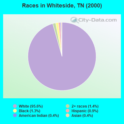
- 1,55195.6%White alone
- 221.4%Two or more races
- 211.3%Black alone
- 140.9%Hispanic
- 70.4%American Indian alone
- 70.4%Asian alone
Races in Whiteside detailed stats: ancestries, foreign born residents, place of birth
According to our research of Tennessee and other state lists, there were 5 registered sex offenders living in Whiteside, Tennessee as of May 15, 2024.
The ratio of all residents to sex offenders in Whiteside is 327 to 1.
The ratio of registered sex offenders to all residents in this city is near the state average.
 Recent articles from our blog. Our writers, many of them Ph.D. graduates or candidates, create easy-to-read articles on a wide variety of topics.
Current Local Time: CST time zone
Elevation: 815 feet
Land area: 42.6 square miles.
Population density: 38 people per square mile (very low).

| Whiteside CCD: | 0.9% ($444) |
| Tennessee: | 0.8% ($715) |
Nearest city with pop. 50,000+: Chattanooga, TN  (14.3 miles , pop. 155,554).
Nearest city with pop. 200,000+: Nashville-Davidson, TN (106.1 miles , pop. 545,524).
Nearest city with pop. 1,000,000+: Chicago, IL (487.1 miles , pop. 2,896,016).
Nearest cities:
), ), )Latitude: 35.00 N, Longitude: 85.51 W

| Here: | 3.6% |
| Tennessee: | 3.0% |
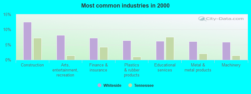
- Construction (12.5%)
- Arts, entertainment, recreation (8.2%)
- Finance & insurance (7.2%)
- Plastics & rubber products (6.4%)
- Educational services (6.2%)
- Metal & metal products (6.1%)
- Machinery (5.9%)
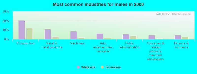
- Construction (20.5%)
- Metal & metal products (11.0%)
- Machinery (8.6%)
- Arts, entertainment, recreation (6.3%)
- Public administration (5.5%)
- Groceries & related products merchant wholesalers (4.6%)
- Finance & insurance (4.6%)
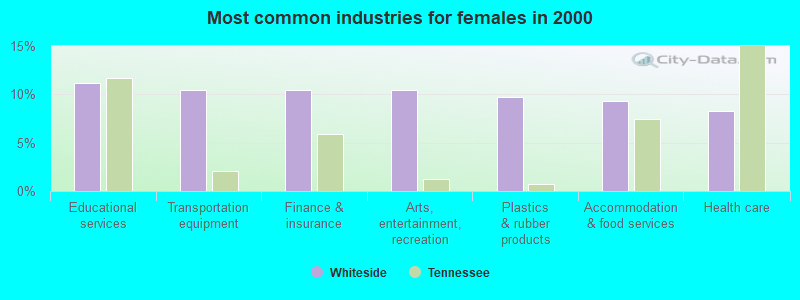
- Educational services (11.2%)
- Transportation equipment (10.4%)
- Finance & insurance (10.4%)
- Arts, entertainment, recreation (10.4%)
- Plastics & rubber products (9.7%)
- Accommodation & food services (9.4%)
- Health care (8.3%)
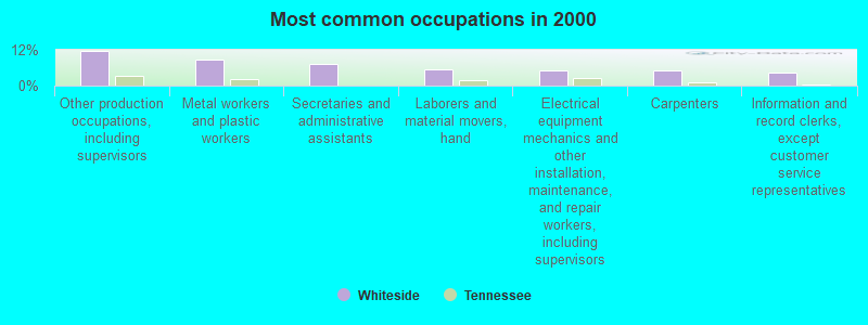
- Other production occupations, including supervisors (11.5%)
- Metal workers and plastic workers (8.6%)
- Secretaries and administrative assistants (7.4%)
- Laborers and material movers, hand (5.6%)
- Electrical equipment mechanics and other installation, maintenance, and repair workers, including supervisors (5.1%)
- Carpenters (5.0%)
- Information and record clerks, except customer service representatives (4.3%)

- Other production occupations, including supervisors (14.7%)
- Metal workers and plastic workers (11.2%)
- Carpenters (8.9%)
- Laborers and material movers, hand (7.2%)
- Electrical equipment mechanics and other installation, maintenance, and repair workers, including supervisors (6.6%)
- Top executives (5.2%)
- Other management occupations, except farmers and farm managers (4.0%)

- Secretaries and administrative assistants (16.5%)
- Information and record clerks, except customer service representatives (9.7%)
- Other production occupations, including supervisors (7.6%)
- Bookkeeping, accounting, and auditing clerks (6.8%)
- Waiters and waitresses (5.4%)
- Cashiers (5.4%)
- Metal workers and plastic workers (5.4%)
Average climate in Whiteside, Tennessee
Based on data reported by over 4,000 weather stations


(lower is better)
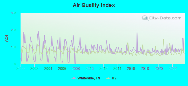
Air Quality Index (AQI) level in 2023 was 94.7. This is worse than average.
| City: | 94.7 |
| U.S.: | 72.6 |

Nitrogen Dioxide (NO2) [ppb] level in 2004 was 3.44. This is significantly better than average. Closest monitor was 9.7 miles away from the city center.
| City: | 3.44 |
| U.S.: | 5.11 |
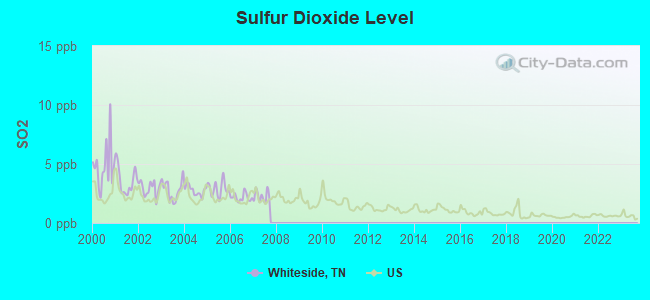
Sulfur Dioxide (SO2) [ppb] level in 2007 was 2.27. This is significantly worse than average. Closest monitor was 9.5 miles away from the city center.
| City: | 2.27 |
| U.S.: | 1.51 |

Ozone [ppb] level in 2023 was 35.2. This is about average. Closest monitor was 12.5 miles away from the city center.
| City: | 35.2 |
| U.S.: | 33.3 |
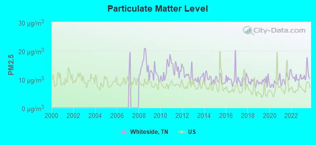
Particulate Matter (PM2.5) [µg/m3] level in 2023 was 11.7. This is significantly worse than average. Closest monitor was 12.2 miles away from the city center.
| City: | 11.7 |
| U.S.: | 8.1 |
Tornado activity:
Whiteside-area historical tornado activity is slightly above Tennessee state average. It is 67% greater than the overall U.S. average.
On 4/3/1974, a category F5 (max. wind speeds 261-318 mph) tornado 43.9 miles away from the Whiteside place center killed 16 people and injured 190 people.
On 2/6/2008, a category F4 (max. wind speeds 207-260 mph) tornado 29.6 miles away from the place center killed one person and injured 12 people.
Earthquake activity:
Whiteside-area historical earthquake activity is significantly above Tennessee state average. It is 123% greater than the overall U.S. average.On 4/29/2003 at 08:59:39, a magnitude 4.9 (4.4 MB, 4.6 MW, 4.9 LG, Class: Light, Intensity: IV - V) earthquake occurred 35.9 miles away from Whiteside center
On 4/29/2003 at 08:59:39, a magnitude 4.6 (4.6 MW, Depth: 12.3 mi) earthquake occurred 35.9 miles away from the city center
On 11/30/1973 at 07:48:41, a magnitude 4.7 (4.7 MB, 4.6 ML) earthquake occurred 103.3 miles away from Whiteside center
On 12/12/2018 at 09:14:43, a magnitude 4.4 (4.4 MW, Depth: 4.9 mi) earthquake occurred 61.0 miles away from Whiteside center
On 1/18/1999 at 07:00:53, a magnitude 4.8 (4.8 MB, 4.0 LG, Depth: 0.6 mi) earthquake occurred 148.8 miles away from the city center
On 4/18/2008 at 09:36:59, a magnitude 5.4 (5.1 MB, 4.8 MS, 5.4 MW, 5.2 MW, Class: Moderate, Intensity: VI - VII) earthquake occurred 272.3 miles away from the city center
Magnitude types: regional Lg-wave magnitude (LG), body-wave magnitude (MB), local magnitude (ML), surface-wave magnitude (MS), moment magnitude (MW)
Natural disasters:
The number of natural disasters in Marion County (19) is greater than the US average (15).Major Disasters (Presidential) Declared: 12
Emergencies Declared: 2
Causes of natural disasters: Floods: 11, Storms: 10, Tornadoes: 6, Winds: 4, Fires: 2, Heavy Rains: 2, Winter Storms: 2, Flash Flood: 1, Hurricane: 1, Landslide: 1, Mudslide: 1, Snowfall: 1, Other: 1 (Note: some incidents may be assigned to more than one category).
Hospitals and medical centers near Whiteside:
- ORANGE GROVE CENTER/CARL SWAFF (Hospital, about 7 miles away; CHATTANOOGA, TN)
- MOCCASSIN BEND MENTAL HEALTH INSTITUTE (Hospital, about 11 miles away; CHATTANOOGA, TN)
- DCI CHATTANOOGA BROAD ST (Dialysis Facility, about 11 miles away; CHATTANOOGA, TN)
- MOUNTAIN VIEW REST HOME (Nursing Home, about 11 miles away; CHATTANOOGA, TN)
- BRIDGE AT SOUTH PITTSBURG, THE (Nursing Home, about 12 miles away; SOUTH PITTSBURG, TN)
- HOSPICE OF CHATTANOOGA (Home Health Center, about 12 miles away; CHATTANOOGA, TN)
- ST BARNABAS NH (Nursing Home, about 12 miles away; CHATTANOOGA, TN)
Colleges/universities with over 2000 students nearest to Whiteside:
- The University of Tennessee-Chattanooga (about 13 miles; Chattanooga, TN; Full-time enrollment: 10,158)
- Chattanooga State Community College (about 18 miles; Chattanooga, TN; FT enrollment: 6,827)
- Southern Adventist University (about 27 miles; Collegedale, TN; FT enrollment: 2,898)
- Dalton State College (about 34 miles; Dalton, GA; FT enrollment: 3,846)
- Lee University (about 39 miles; Cleveland, TN; FT enrollment: 4,422)
- Cleveland State Community College (about 39 miles; Cleveland, TN; FT enrollment: 2,500)
- Northeast Alabama Community College (about 39 miles; Rainsville, AL; FT enrollment: 2,409)
Points of interest:
Notable locations in Whiteside: Hales Bar Dam (A), Hales Bar Resort and Marina (B), Mapleview Campsite (C), Mullins Cove Dock (D), Walkers Landing Boat Dock (E), Aetna (F), Haletown Volunteer Fire Department (G). Display/hide their locations on the map
Churches in Whiteside include: Whiteside Baptist Church (A), Hales Chapel United Methodist Church (B), Guild First Baptist Church (C), Kelly's Ferry Church of God (D), Whiteside Church of God (E), Whiteside United Methodist Church (F), Macedonia Church (G). Display/hide their locations on the map
Cemeteries: Ladds Cemetery (1), Lee Cemetery (2), Aetna Cemetery (3), McNabb Cemetery (4), Hale Cemetery (5), Hales Chapel Cemetery (6), Burnett Cemetery (7). Display/hide their locations on the map
Lakes and reservoirs: Cummings Lake (A), Raccoon Mountain Pumped Station Reservoir (B), Raccoon Mountain Pumped Station Reserve (C). Display/hide their locations on the map
Streams, rivers, and creeks: Hugden Branch (A), Huff Branch (B), Hogjaw Creek (C), Spring Creek (D), Dry Creek (E), Alley Gulf Branch (F), Hix Hollow Branch (G), Moroney Gulf Branch (H), John McNabb Branch (I). Display/hide their locations on the map
Parks in Whiteside include: Maple View Public Use Area (1), Running Water Public Use Area (2). Display/hide their locations on the map
| This place: | 2.4 people |
| Tennessee: | 2.5 people |
| This place: | 66.9% |
| Whole state: | 69.8% |
| This place: | 3.6% |
| Whole state: | 4.2% |
Likely homosexual households (counted as self-reported same-sex unmarried-partner households)
- Lesbian couples: 0.0% of all households
- Gay men: 0.4% of all households
| This place: | 9.3% |
| Whole state: | 13.5% |
| This place: | 2.5% |
| Whole state: | 5.8% |
For population 15 years and over in Whiteside:
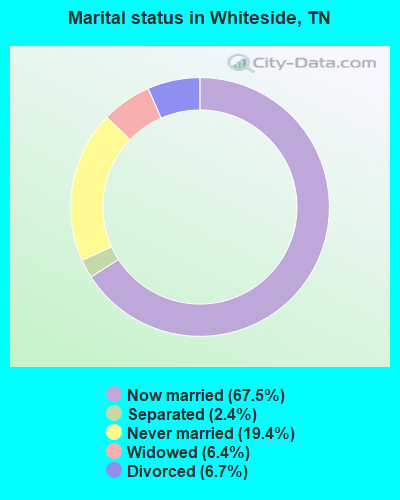
- Never married: 19.4%
- Now married: 67.5%
- Separated: 2.4%
- Widowed: 6.4%
- Divorced: 6.7%
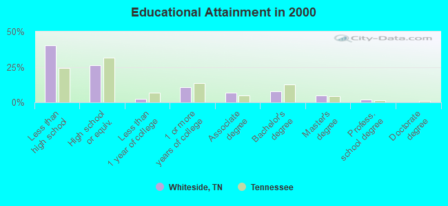
For population 25 years and over in Whiteside:
- High school or higher: 59.9%
- Bachelor's degree or higher: 14.1%
- Graduate or professional degree: 6.4%
- Unemployed: 9.9%
- Mean travel time to work (commute): 26.4 minutes
| Here: | 16.4 |
| Tennessee average: | 13.3 |
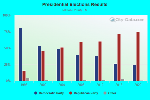
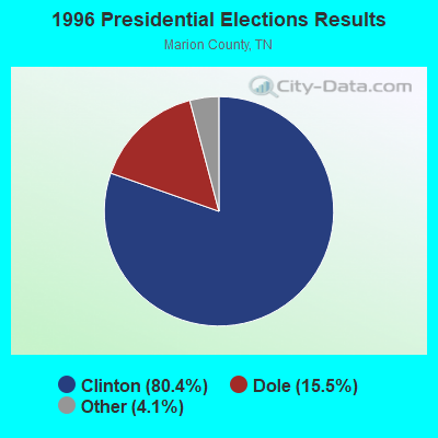
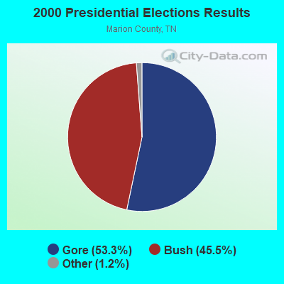


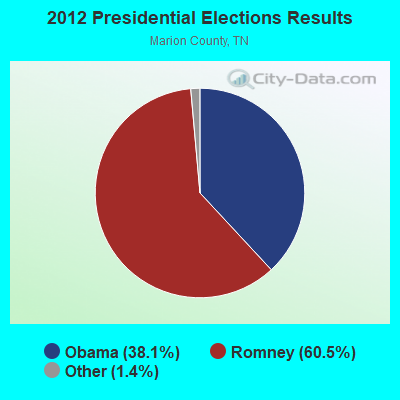
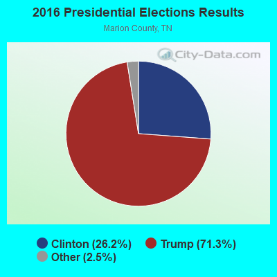

Graphs represent county-level data. Detailed 2008 Election Results
Religion statistics for Whiteside, TN (based on Marion County data)
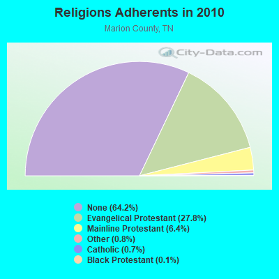
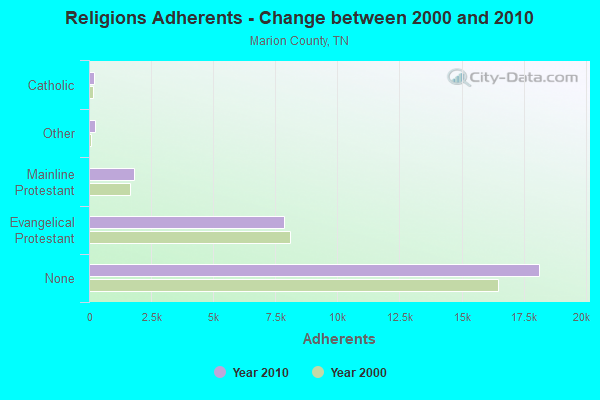
| Religion | Adherents | Congregations |
|---|---|---|
| Evangelical Protestant | 7,840 | 55 |
| Mainline Protestant | 1,803 | 15 |
| Other | 229 | 2 |
| Catholic | 200 | 2 |
| Black Protestant | 30 | 1 |
| None | 18,135 | - |
Food Environment Statistics:
| This county: | 1.78 / 10,000 pop. |
| State: | 1.99 / 10,000 pop. |
| This county: | 0.36 / 10,000 pop. |
| State: | 0.17 / 10,000 pop. |
| This county: | 1.42 / 10,000 pop. |
| State: | 0.65 / 10,000 pop. |
| This county: | 8.18 / 10,000 pop. |
| Tennessee: | 5.16 / 10,000 pop. |
| This county: | 8.18 / 10,000 pop. |
| Tennessee: | 6.56 / 10,000 pop. |
| This county: | 12.3% |
| Tennessee: | 11.4% |
| Marion County: | 30.9% |
| Tennessee: | 30.2% |
| This county: | 10.1% |
| Tennessee: | 13.5% |
Strongest AM radio stations in Whiteside:
- WWAM (820 AM; daytime; 50 kW; JASPER, TN; Owner: SHELTON BROADCASTING SYSTEM)
- WFLI (1070 AM; 50 kW; LOOKOUT MOUNTAIN, TN; Owner: WFLI, INC.)
- WEPG (910 AM; 5 kW; SOUTH PITTSBURG, TN; Owner: STONE/COLLINS COMMUNICATIONS, INC.)
- WDEF (1370 AM; 5 kW; CHATTANOOGA, TN; Owner: JACKSON TELECASTERS, INC)
- WGOW (1150 AM; 5 kW; CHATTANOOGA, TN; Owner: CITADEL BROADCASTING COMPANY)
- WDOD (1310 AM; 5 kW; CHATTANOOGA, TN; Owner: WDOD OF CHATTANOOGA, INC.)
- WNOO (1260 AM; 5 kW; CHATTANOOGA, TN; Owner: PYE BROADCASTING, INC.)
- WKWN (1420 AM; 2 kW; TRENTON, GA; Owner: RA-AD OF TRENTON, INC.)
- WQRX (870 AM; daytime; 10 kW; VALLEY HEAD, AL; Owner: BARINOWSKI INVESTMENT COMPANY)
- WNSI (810 AM; 50 kW; JACKSONVILLE, AL; Owner: UNITED BROADCASTING NETWORK, INC.)
- WLOR (1550 AM; 50 kW; HUNTSVILLE, AL; Owner: BCA RADIO, LLC)
- WSM (650 AM; 50 kW; NASHVILLE, TN; Owner: GAYLORD ENTERTAINMENT COMPANY)
- WTTI (1530 AM; daytime; 10 kW; DALTON, GA; Owner: PYE WILSON BROADCASTING, INC.)
Strongest FM radio stations in Whiteside:
- WMBW (88.9 FM; CHATTANOOGA, TN; Owner: THE MOODY BIBLE INSTITUTE OF CHICAGO)
- W257AZ (99.3 FM; LOOKOUT MOUNTAIN, TN; Owner: CAPSTAR TX LIMITED PARTNERSHIP)
- WBDX (102.7 FM; TRENTON, GA; Owner: PARTNERS FOR CHRISTIAN RADIO, INC.)
- WUSY (100.7 FM; CLEVELAND, TN; Owner: CAPSTAR TX LIMITED PARTNERSHIP)
- WMXF-FM (97.3 FM; SOUTH PITTSBURG, TN; Owner: CAPSTAR TX LIMITED PARTNERSHIP)
- WKXJ (98.1 FM; SIGNAL MOUNTAIN, TN; Owner: CAPSTAR TX LIMITED PARTNERSHIP)
- WDEF-FM (92.3 FM; CHATTANOOGA, TN; Owner: JACKSON TELECASTERS, INC.)
- WDOD-FM (96.5 FM; CHATTANOOGA, TN; Owner: WDOD OF CHATTANOOGA, INC.)
- WSKZ (106.5 FM; CHATTANOOGA, TN; Owner: CITADEL BROADCASTING COMPANY)
- WOGT (107.9 FM; EAST RIDGE, TN; Owner: CITADEL BROADCASTING COMPANY)
- W278AC (103.5 FM; WALDEN, TN; Owner: CAPSTAR TX LIMITED PARTNERSHIP)
- WDYN (89.7 FM; CHATTANOOGA, TN; Owner: TENNESSEE TEMPLE UNIVERSITY)
- WAWL-FM (91.5 FM; RED BANK, TN; Owner: CHATTANOOGA STATE TECHNICAL COMMUNITY COLLEGE)
- WRXR-FM (105.5 FM; ROSSVILLE, GA; Owner: CAPSTAR TX LIMITED PARTNERSHIP)
- WUTC (88.1 FM; CHATTANOOGA, TN; Owner: UNIVERSITY OF TENNESSEE)
- W284AE (104.7 FM; ORCHARD HILLS, GA; Owner: WAY-FM MEDIA GROUP, INC.)
- W268AA (101.5 FM; FALLING WATER, TN; Owner: S/WEST FLORIDA COMMUNITY RADIO, INC.)
- WLOV-FM1 (97.3 FM; CHATTANOOGA, TN; Owner: CAPSTAR TX LIMITED PARTNERSHIP)
- WSMC-FM (90.5 FM; COLLEGEDALE, TN; Owner: SOUTHERN COLLEGE OF SEVENTH-DAY ADVT)
- W241AF (96.1 FM; ROSSVILLE, GA; Owner: IMMANUEL BROADCASTING NETWORK, INC.)
TV broadcast stations around Whiteside:
- WFLI-TV (Channel 53; CLEVELAND, TN; Owner: CHATTANOOGA MEDIA HOLDINGS, L.L.C.)
- WELF (Channel 23; DALTON, GA; Owner: TRINITY BROADCASTING NETWORK)
- WDEF-TV (Channel 12; CHATTANOOGA, TN; Owner: MEDIA GENERAL COMMUNICATIONS, INC.)
- WRCB-TV (Channel 3; CHATTANOOGA, TN; Owner: SARKES TARZIAN, INC.)
- WDSI-TV (Channel 61; CHATTANOOGA, TN; Owner: WDSI LICENSE CORP.)
- WTCI (Channel 45; CHATTANOOGA, TN; Owner: THE GREATER CHATTANOOGA PUBLIC TELEVISION CORP)
- WTVC (Channel 9; CHATTANOOGA, TN; Owner: FREEDOM BROADCASTING OF TENNESSEE, INC.)
- W26BE (Channel 26; CHATTANOOGA, TN; Owner: THREE ANGELS BROADCASTING NETWORK)
- W64BJ (Channel 64; SCOTTSBORO, AL; Owner: TRINITY BROADCASTING NETWORK)
- WOOT-LP (Channel 6; CHATTANOOGA, ETC., TN; Owner: TIGER EYE BROADCASTING CORPORATION)
- WCNT-LP (Channel 65; CHATTANOOGA, TN; Owner: NORTH GEORGIA TELEVISION)
- WYHB-CA (Channel 39; CHATTANOOGA, TN; Owner: YING HUA BENNS)
Whiteside fatal accident list:
FCC Registered Antenna Towers:
32 (See the full list of FCC Registered Antenna Towers in Whiteside)FCC Registered Broadcast Land Mobile Towers:
3- 1/2 Mi N Of Sr 134 And Scratch Ankl (Lat: 34.997306 Lon: -85.508583), Type: Pole, Structure height: 14 m, Overall height: 17 m, Call Sign: WPOY219,
Assigned Frequencies: 896.887 MHz, 896.937 MHz, 896.987 MHz, 897.887 MHz, 897.937 MHz, 897.987 MHz, Grant Date: 08/31/1999, Expiration Date: 08/31/2004, Cancellation Date: 11/06/2004, Certifier: Robert M Vandeberg, Registrant: Ttci Csxt, 55500 D O T Rd, Pueblo, CO 81001, Fax: (719) 584-0791
- .5 Mi N Of Sr 134 & Scratch Ankle Rd At Csxt Row (Lat: 34.989500 Lon: -85.499056), Type: Pole, Structure height: 14 m, Overall height: 17 m, Call Sign: WPPC805,
Assigned Frequencies: 160.350 MHz, 160.395 MHz, 160.785 MHz, 161.370 MHz, 161.415 MHz, Grant Date: 08/08/2014, Expiration Date: 10/26/2024, Certifier: L W Allen, Registrant: Csx Transportation Inc, 6735 Southpoint Dr. S, 4th Flr, Jacksonville, FL 32216, Phone: (904) 332-5925, Fax: (904) 332-6013, Email:
- L1, Lat: 34.989500 Lon: -85.499056, Call Sign: WQXW213,
Assigned Frequencies: 160.785 MHz, Grant Date: 06/27/2016, Expiration Date: 06/27/2026, Certifier: Shantrice Cruse-Scott, Registrant: Csx Transportation Inc, 6735 Southpoint Dr So, 4th Flr J958, Jacksonville, FL 32216-6177, Phone: (904) 332-5925, Fax: (904) 332-6013, Email:
FCC Registered Amateur Radio Licenses:
1- Call Sign: KG4EJG, Licensee ID: L00145226, Grant Date: 08/27/1999, Expiration Date: 08/27/2009, Cancellation Date: 08/30/2011, Certifier: John E Blevins, Registrant: John E Blevins, Whiteside, TN 37396-1842
FAA Registered Aircraft:
2- Aircraft: PIPER PA-32-260 (Category: Land, Seats: 6, Weight: Up to 12,499 Pounds, Speed: 126 mph), Engine: LYCOMING 0-540 SERIES (250 HP) (Reciprocating)
N-Number: 3780W, N3780W, N-3780W, Serial Number: 32-702, Year manufactured: 1966, Certificate Issue Date: 12/30/2014
Registrant (Individual): Marshall A Jr Raines, Po Box 264, Whiteside, TN 37396 - Aircraft: PIPER PA-28-140 (Category: Land, Seats: 4, Weight: Up to 12,499 Pounds, Speed: 107 mph), Engine: LYCOMING IO-320 SERIES (150 HP) (Reciprocating)
N-Number: 95428, N95428, N-95428, Serial Number: 28-25946, Year manufactured: 1969, Airworthiness Date: 05/23/1969, Certificate Issue Date: 02/11/2015
Registrant (Individual): Matthew A Raines, Po Box 264, Whiteside, TN 37396
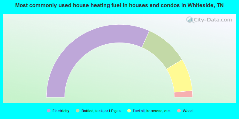
- 63.4%Electricity
- 19.3%Bottled, tank, or LP gas
- 14.4%Fuel oil, kerosene, etc.
- 2.9%Wood
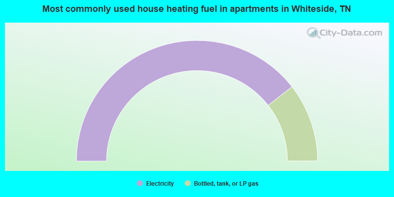
- 78.9%Electricity
- 21.1%Bottled, tank, or LP gas
Whiteside compared to Tennessee state average:
- Median house value below state average.
- Black race population percentage significantly below state average.
- Hispanic race population percentage significantly below state average.
- Foreign-born population percentage significantly below state average.
- Renting percentage significantly below state average.
- Length of stay since moving in significantly above state average.
- Number of rooms per house significantly below state average.
- House age significantly below state average.
- Number of college students significantly below state average.
- Percentage of population with a bachelor's degree or higher below state average.