Woods Heights, Missouri
Submit your own pictures of this city and show them to the world
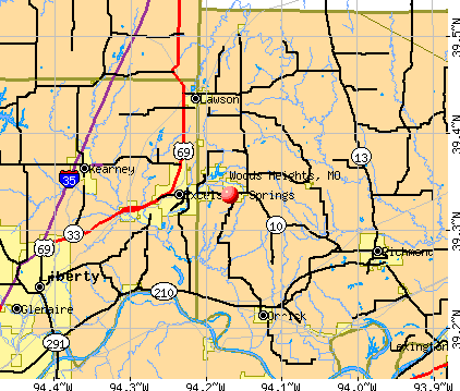
- OSM Map
- General Map
- Google Map
- MSN Map
| Males: 389 | |
| Females: 357 |
| Median resident age: | 34.9 years |
| Missouri median age: | 36.1 years |
Zip codes: 64024.
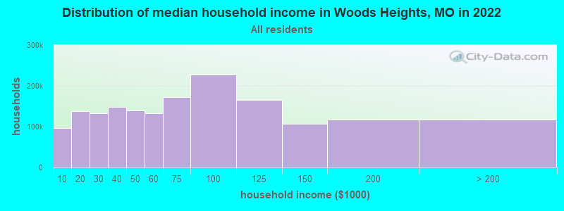
| Woods Heights: | $83,942 |
| MO: | $64,811 |
Estimated per capita income in 2022: $34,417 (it was $18,120 in 2000)
Woods Heights city income, earnings, and wages data
Estimated median house or condo value in 2022: $194,968 (it was $88,500 in 2000)
| Woods Heights: | $194,968 |
| MO: | $221,200 |
Detailed information about poverty and poor residents in Woods Heights, MO


- 70895.4%White alone
- 202.7%Hispanic
- 60.8%Two or more races
- 50.7%Black alone
- 10.1%American Indian alone
- 10.1%Native Hawaiian and Other
Pacific Islander alone - 10.1%Other race alone
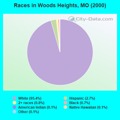
Races in Woods Heights detailed stats: ancestries, foreign born residents, place of birth
 Recent articles from our blog. Our writers, many of them Ph.D. graduates or candidates, create easy-to-read articles on a wide variety of topics.

Ancestries: German (16.3%), United States (15.5%), Irish (11.3%), English (9.0%), Scotch-Irish (4.2%), Scottish (3.2%).
Current Local Time: CST time zone
Land area: 2.25 square miles.
Population density: 332 people per square mile (very low).
1 resident is foreign born
| This city: | 0.1% |
| Missouri: | 2.7% |
| Woods Heights city: | 1.0% ($842) |
| Missouri: | 1.0% ($851) |
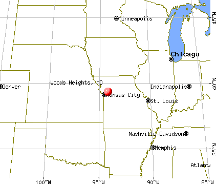
Nearest city with pop. 50,000+: Independence, MO  (21.8 miles , pop. 113,288).
Nearest city with pop. 200,000+: Kansas City, MO (27.4 miles , pop. 441,545).
Nearest city with pop. 1,000,000+: Chicago, IL (382.2 miles , pop. 2,896,016).
Nearest cities:
), ), ), )Latitude: 39.34 N, Longitude: 94.17 W
Area code commonly used in this area: 816
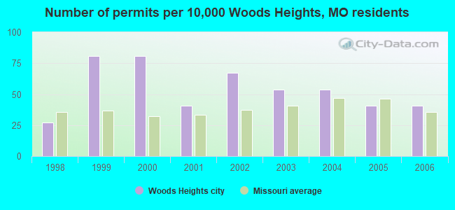
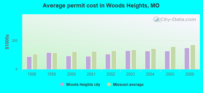
Single-family new house construction building permits:
- 2006: 3 buildings, average cost: $151,300
- 2005: 3 buildings, average cost: $129,100
- 2004: 4 buildings, average cost: $128,800
- 2003: 4 buildings, average cost: $129,900
- 2002: 5 buildings, average cost: $107,400
- 2001: 3 buildings, average cost: $91,700
- 2000: 6 buildings, average cost: $93,300
- 1999: 6 buildings, average cost: $116,700
- 1998: 2 buildings, average cost: $90,000
| Here: | 2.8% |
| Missouri: | 2.8% |
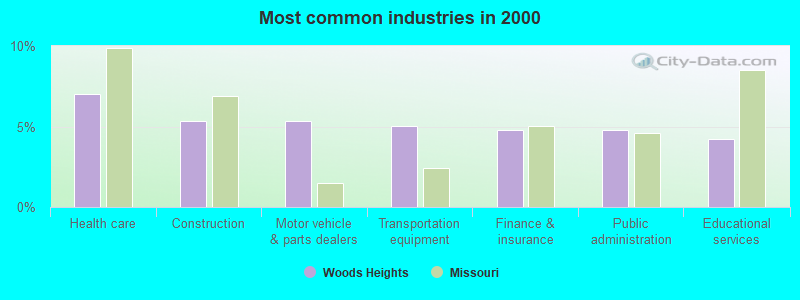
- Health care (7.0%)
- Construction (5.3%)
- Motor vehicle & parts dealers (5.3%)
- Transportation equipment (5.1%)
- Finance & insurance (4.8%)
- Public administration (4.8%)
- Educational services (4.2%)
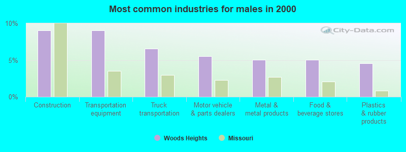
- Construction (9.0%)
- Transportation equipment (9.0%)
- Truck transportation (6.5%)
- Motor vehicle & parts dealers (5.5%)
- Metal & metal products (5.0%)
- Food & beverage stores (5.0%)
- Plastics & rubber products (4.5%)
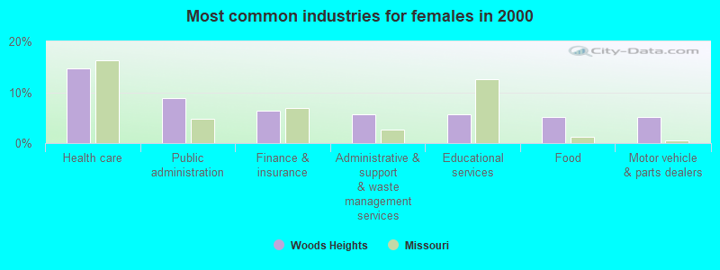
- Health care (14.6%)
- Public administration (8.9%)
- Finance & insurance (6.4%)
- Administrative & support & waste management services (5.7%)
- Educational services (5.7%)
- Food (5.1%)
- Motor vehicle & parts dealers (5.1%)
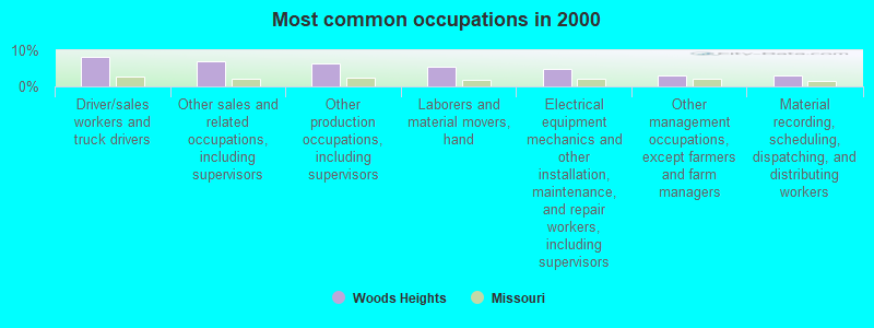
- Driver/sales workers and truck drivers (8.1%)
- Other sales and related occupations, including supervisors (7.0%)
- Other production occupations, including supervisors (6.5%)
- Laborers and material movers, hand (5.3%)
- Electrical equipment mechanics and other installation, maintenance, and repair workers, including supervisors (4.8%)
- Other management occupations, except farmers and farm managers (3.1%)
- Material recording, scheduling, dispatching, and distributing workers (3.1%)
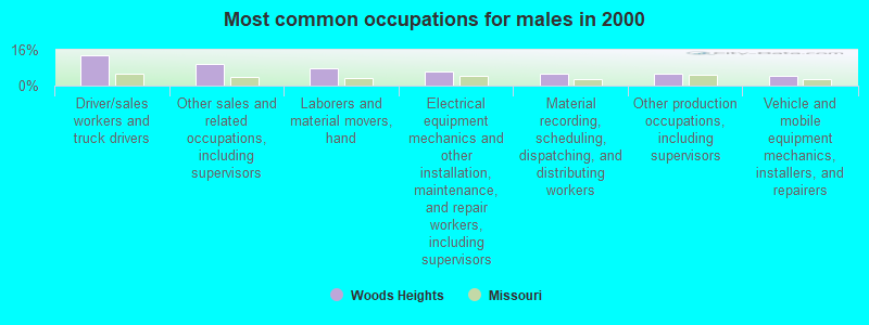
- Driver/sales workers and truck drivers (13.6%)
- Other sales and related occupations, including supervisors (9.5%)
- Laborers and material movers, hand (7.5%)
- Electrical equipment mechanics and other installation, maintenance, and repair workers, including supervisors (6.5%)
- Material recording, scheduling, dispatching, and distributing workers (5.5%)
- Other production occupations, including supervisors (5.5%)
- Vehicle and mobile equipment mechanics, installers, and repairers (4.5%)
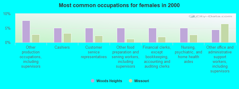
- Other production occupations, including supervisors (7.6%)
- Cashiers (5.1%)
- Customer service representatives (5.1%)
- Other food preparation and serving workers, including supervisors (5.1%)
- Financial clerks, except bookkeeping, accounting and auditing clerks (5.1%)
- Nursing, psychiatric, and home health aides (5.1%)
- Other office and administrative support workers, including supervisors (4.5%)
Average climate in Woods Heights, Missouri
Based on data reported by over 4,000 weather stations


(lower is better)
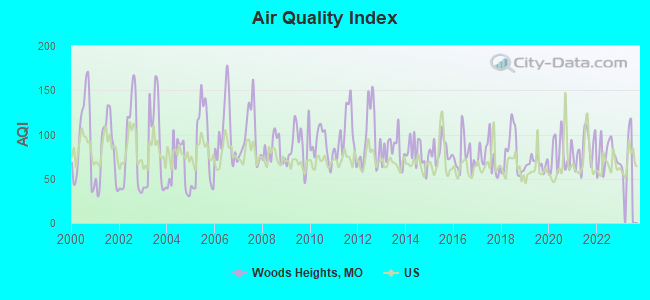
Air Quality Index (AQI) level in 2022 was 76.5. This is about average.
| City: | 76.5 |
| U.S.: | 72.6 |
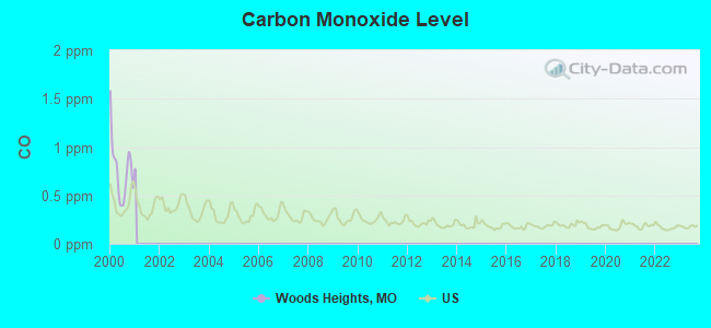
Carbon Monoxide (CO) [ppm] level in 2000 was 0.768. This is significantly worse than average. Closest monitor was 23.5 miles away from the city center.
| City: | 0.768 |
| U.S.: | 0.251 |
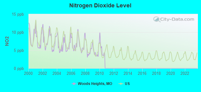
Nitrogen Dioxide (NO2) [ppb] level in 2010 was 5.32. This is about average. Closest monitor was 11.4 miles away from the city center.
| City: | 5.32 |
| U.S.: | 5.11 |
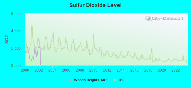
Sulfur Dioxide (SO2) [ppb] level in 2001 was 1.35. This is about average. Closest monitor was 20.5 miles away from the city center.
| City: | 1.35 |
| U.S.: | 1.51 |
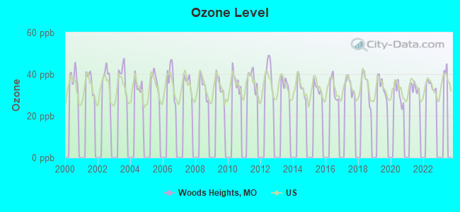
Ozone [ppb] level in 2022 was 34.6. This is about average. Closest monitor was 7.1 miles away from the city center.
| City: | 34.6 |
| U.S.: | 33.3 |
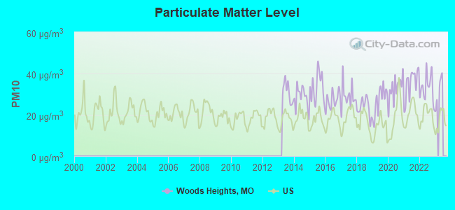
Particulate Matter (PM10) [µg/m3] level in 2022 was 32.9. This is significantly worse than average. Closest monitor was 23.1 miles away from the city center.
| City: | 32.9 |
| U.S.: | 19.2 |
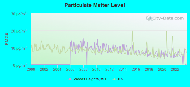
Particulate Matter (PM2.5) [µg/m3] level in 2022 was 5.66. This is significantly better than average. Closest monitor was 11.4 miles away from the city center.
| City: | 5.66 |
| U.S.: | 8.11 |
Tornado activity:
Woods Heights-area historical tornado activity is slightly above Missouri state average. It is 83% greater than the overall U.S. average.
On 5/20/1957, a category F5 (max. wind speeds 261-318 mph) tornado 27.6 miles away from the Woods Heights city center killed 44 people and injured 207 people and caused between $500,000 and $5,000,000 in damages.
On 5/4/1977, a category F4 (max. wind speeds 207-260 mph) tornado 9.1 miles away from the city center injured one person and caused between $500,000 and $5,000,000 in damages.
Earthquake activity:
Woods Heights-area historical earthquake activity is significantly above Missouri state average. It is 454% greater than the overall U.S. average.On 9/3/2016 at 12:02:44, a magnitude 5.8 (5.8 MW, Depth: 3.5 mi, Class: Moderate, Intensity: VI - VII) earthquake occurred 251.5 miles away from Woods Heights center
On 11/6/2011 at 03:53:10, a magnitude 5.7 (5.7 MW, Depth: 3.2 mi) earthquake occurred 299.2 miles away from the city center
On 11/12/2014 at 21:40:00, a magnitude 4.9 (4.9 MW, Depth: 2.5 mi, Class: Light, Intensity: IV - V) earthquake occurred 235.6 miles away from Woods Heights center
On 4/18/2008 at 09:36:59, a magnitude 5.4 (5.1 MB, 4.8 MS, 5.4 MW, 5.2 MW) earthquake occurred 343.6 miles away from the city center
On 11/7/2016 at 01:44:24, a magnitude 5.0 (5.0 MW, Depth: 2.8 mi) earthquake occurred 272.6 miles away from the city center
On 9/26/1990 at 13:18:51, a magnitude 5.0 (4.7 MB, 4.8 LG, 5.0 LG, Depth: 7.7 mi) earthquake occurred 293.0 miles away from the city center
Magnitude types: regional Lg-wave magnitude (LG), body-wave magnitude (MB), surface-wave magnitude (MS), moment magnitude (MW)
Natural disasters:
The number of natural disasters in Ray County (31) is a lot greater than the US average (15).Major Disasters (Presidential) Declared: 22
Emergencies Declared: 6
Causes of natural disasters: Floods: 22, Storms: 19, Tornadoes: 12, Winter Storms: 4, Winds: 2, Drought: 1, Heavy Rain: 1, Hurricane: 1, Ice Storm: 1, Snowstorm: 1, Other: 1 (Note: some incidents may be assigned to more than one category).
Hospitals and medical centers near Woods Heights:
- ROYAL CARE CENTER INC (Nursing Home, about 4 miles away; EXCELSIOR SPRINGS, MO)
- EXCELSIOR SPRINGS HOSPITAL HOME HEALTH/HOSPICE (Home Health Center, about 5 miles away; EXCELSIOR SPRINGS, MO)
- EXCELSIOR SPRINGS MEDICAL CENTER (Nursing Home, about 5 miles away; EXCELSIOR SPRINGS, MO)
- VALLEY MANOR AND REHABILITATION CENTER (Nursing Home, about 5 miles away; EXCELSIOR SPRINGS, MO)
- EXCELSIOR SPRINGS CITY HOSP AND CONV (Nursing Home, about 5 miles away; EXCELSIOR SPRINGS, MO)
- LAWSON MANOR AND REHAB (Nursing Home, about 8 miles away; LAWSON, MO)
- SHIRKEY NURSING AND REHABILITATION CENTER (Nursing Home, about 13 miles away; RICHMOND, MO)
Colleges/universities with over 2000 students nearest to Woods Heights:
- Grantham University (about 28 miles; Kansas City, MO; Full-time enrollment: 8,385)
- Park University (about 30 miles; Parkville, MO; FT enrollment: 9,131)
- Metropolitan Community College-Kansas City (about 30 miles; Kansas City, MO; FT enrollment: 12,834)
- Rockhurst University (about 31 miles; Kansas City, MO; FT enrollment: 2,013)
- University of Missouri-Kansas City (about 31 miles; Kansas City, MO; FT enrollment: 10,544)
- Kansas City Kansas Community College (about 35 miles; Kansas City, KS; FT enrollment: 4,718)
- Wright Career College (about 39 miles; Overland Park, KS; FT enrollment: 3,107)
Points of interest:
Notable location: Wood Heights Fire Protection District (A). Display/hide its location on the map
Church in Woods Heights: Pisgah Church (A). Display/hide its location on the map
Reservoir: Woods Lake (A). Display/hide its location on the map
| This city: | 3.0 people |
| Missouri: | 2.5 people |
| This city: | 85.9% |
| Whole state: | 67.7% |
| This city: | 3.2% |
| Whole state: | 5.1% |
Likely homosexual households (counted as self-reported same-sex unmarried-partner households)
- Lesbian couples: 0.4% of all households
- Gay men: 0.8% of all households
| This city: | 2.2% |
| Whole state: | 11.7% |
| This city: | 1.8% |
| Whole state: | 5.1% |
For population 15 years and over in Woods Heights:
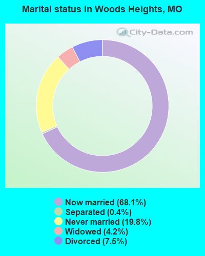
- Never married: 19.8%
- Now married: 68.1%
- Separated: 0.4%
- Widowed: 4.2%
- Divorced: 7.5%
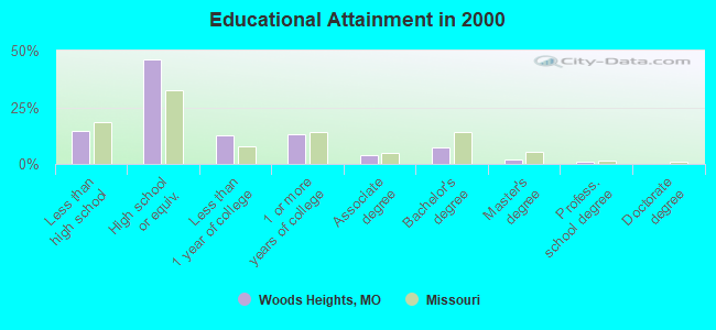
For population 25 years and over in Woods Heights:
- High school or higher: 85.5%
- Bachelor's degree or higher: 10.3%
- Graduate or professional degree: 2.9%
- Unemployed: 5.8%
- Mean travel time to work (commute): 29.3 minutes
| Here: | 8.3 |
| Missouri average: | 11.7 |
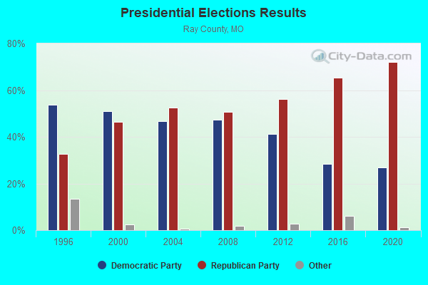
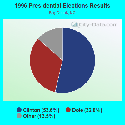
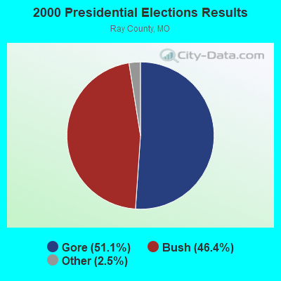
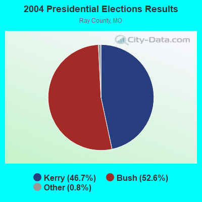
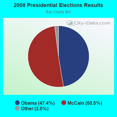
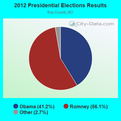
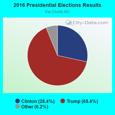
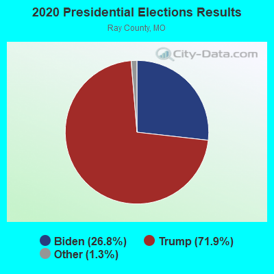
Graphs represent county-level data. Detailed 2008 Election Results
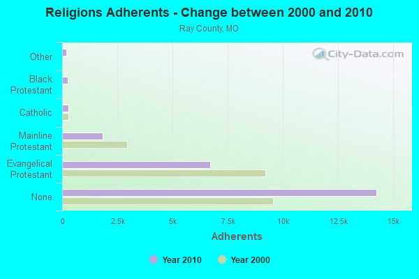
Religion statistics for Woods Heights, MO (based on Ray County data)
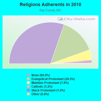
| Religion | Adherents | Congregations |
|---|---|---|
| Evangelical Protestant | 6,690 | 35 |
| Mainline Protestant | 1,839 | 13 |
| Catholic | 291 | 1 |
| Black Protestant | 246 | 2 |
| Other | 181 | 2 |
| None | 14,247 | - |
Food Environment Statistics:
| This county: | 1.28 / 10,000 pop. |
| State: | 1.88 / 10,000 pop. |
| This county: | 0.43 / 10,000 pop. |
| Missouri: | 0.18 / 10,000 pop. |
| Ray County: | 5.97 / 10,000 pop. |
| Missouri: | 4.34 / 10,000 pop. |
| Ray County: | 4.69 / 10,000 pop. |
| State: | 7.37 / 10,000 pop. |
| This county: | 10.2% |
| Missouri: | 8.8% |
| Ray County: | 30.3% |
| Missouri: | 29.6% |
| Ray County: | 7.4% |
| State: | 13.5% |
| Local government employment and payroll (March 2007) | |||||
| Function | Full-time employees | Monthly full-time payroll | Average yearly full-time wage | Part-time employees | Monthly part-time payroll |
|---|---|---|---|---|---|
| Other Government Administration | 1 | $2,185 | $26,220 | 5 | $128 |
| Police Protection - Officers | 1 | $3,790 | $45,480 | 1 | $144 |
| Police - Other | 0 | $0 | 1 | $787 | |
| Judicial and Legal | 0 | $0 | 3 | $1,205 | |
| Financial Administration | 0 | $0 | 0 | $0 | |
| Other and Unallocable | 0 | $0 | 1 | $356 | |
| Water Supply | 0 | $0 | 1 | $362 | |
| Totals for Government | 2 | $5,975 | $35,850 | 12 | $2,982 |
Woods Heights government finances - Expenditure in 2002 (per resident):
- Current Operations - Sewerage: $103,000 ($138.07)
Water Utilities: $89,000 ($119.30)
Central Staff Services: $87,000 ($116.62)
Parks and Recreation: $50,000 ($67.02)
Solid Waste Management: $42,000 ($56.30)
Police Protection: $22,000 ($29.49)
Regular Highways: $21,000 ($28.15)
Judicial and Legal Services: $6,000 ($8.04)
- Other Capital Outlay - General - Other: $22,000 ($29.49)
- Total Salaries and Wages: $236,000 ($316.35)
- Water Utilities - Interest on Debt: $18,000 ($24.13)
Woods Heights government finances - Revenue in 2002 (per resident):
- Charges - Sewerage: $103,000 ($138.07)
Solid Waste Management: $52,000 ($69.71)
Other: $11,000 ($14.75)
- Miscellaneous - Fines and Forfeits: $27,000 ($36.19)
Donations From Private Sources: $1,000 ($1.34)
- Revenue - Water Utilities: $183,000 ($245.31)
- State Intergovernmental - Other: $50,000 ($67.02)
Highways: $29,000 ($38.87)
- Tax - General Sales and Gross Receipts: $45,000 ($60.32)
Public Utilities Sales: $37,000 ($49.60)
Property: $29,000 ($38.87)
Other License: $1,000 ($1.34)
Occupation and Business License - Other: $1,000 ($1.34)
Other Selective Sales: $1,000 ($1.34)
Woods Heights government finances - Debt in 2002 (per resident):
- Long Term Debt - Beginning Outstanding - Unspecified Public Purpose: $565,000 ($757.37)
Outstanding Unspecified Public Purpose: $534,000 ($715.82)
Retired Unspecified Public Purpose: $32,000 ($42.90)
Woods Heights government finances - Cash and Securities in 2002 (per resident):
- Bond Fund - Cash and Deposits: $46,000 ($61.66)
- Other Funds - Cash and Deposits: $93,000 ($124.66)
Strongest AM radio stations in Woods Heights:
- WHB (810 AM; 50 kW; KANSAS CITY, MO; Owner: UNION BROADCASTING, INC.)
- KEXS (1090 AM; daytime; 1 kW; EXCELSIOR SPRINGS, MO; Owner: JEFFCO TELEVISION CORP.)
- KKHK (1250 AM; 25 kW; KANSAS CITY, KS)
- KCMO (710 AM; 10 kW; KANSAS CITY, MO; Owner: SUSQUEHANNA KANSAS CITY PARTNERSHIP)
- KCTE (1510 AM; daytime; 10 kW; INDEPENDENCE, MO; Owner: UNION BROADCASTING, INC.)
- KCCV (760 AM; daytime; 6 kW; OVERLAND PARK, KS; Owner: BOTT BROADCASTING COMPANY)
- KCSP (610 AM; 5 kW; KANSAS CITY, MO; Owner: ENTERCOM KANSAS CITY LICENSE, LLC)
- KXTR (1660 AM; 10 kW; KANSAS CITY, KS; Owner: ENTERCOM KANSAS CITY LICENSE, LLC)
- KPHN (1190 AM; 5 kW; KANSAS CITY, MO; Owner: ABC, INC.)
- KMBZ (980 AM; 5 kW; KANSAS CITY, MO; Owner: ENTERCOM KANSAS CITY LICENSE, LLC)
- KFEQ (680 AM; 5 kW; ST. JOSEPH, MO; Owner: EAGLE RADIO, INC.)
- KGGN (890 AM; daytime; 1 kW; GLADSTONE, MO; Owner: MORTENSON BROADCASTING COMPANY, INC.)
- KCWJ (1030 AM; 1 kW; BLUE SPRINGS, MO; Owner: CHRISTIAN BROADCASTING ASSOCIATES, LP)
Strongest FM radio stations in Woods Heights:
- KAYX (92.5 FM; RICHMOND, MO; Owner: BOTT COMMUNICATIONS, INC.)
- KMJK (107.3 FM; LEXINGTON, MO; Owner: ALLUR-KANSAS CITY, INC.)
- KSRC (102.1 FM; KANSAS CITY, MO; Owner: INFINITY RADIO OPERATIONS INC.)
- WDAF-FM (106.5 FM; LIBERTY, MO; Owner: ENTERCOM KANSAS CITY LICENSE, LLC)
- KUDL (98.1 FM; KANSAS CITY, KS; Owner: ENTERCOM KANSAS CITY LICENSE, LLC)
- KBEQ-FM (104.3 FM; KANSAS CITY, MO; Owner: INFINITY RADIO SUBSIDIARY OPERATIONS INC.)
- KZPL (97.3 FM; LEE'S SUMMIT, MO; Owner: UNION FIRST BROADCASTING, LLC)
- KCMO-FM (94.9 FM; KANSAS CITY, MO; Owner: SUSQUEHANNA KANSAS CITY PARTNERSHIP)
- KQRC-FM (98.9 FM; LEAVENWORTH, KS; Owner: ENTERCOM KANSAS CITY LICENSE, LLC)
- KRBZ (96.5 FM; KANSAS CITY, MO; Owner: ENTERCOM KANSAS CITY LICENSE, LLC)
- KYYS (99.7 FM; KANSAS CITY, MO; Owner: ENTERCOM KANSAS CITY LICENSE, LLC)
- KMXV (93.3 FM; KANSAS CITY, MO; Owner: INFINITY RADIO OPERATIONS INC.)
- KCUR-FM (89.3 FM; KANSAS CITY, MO; Owner: CURATORS OF UNIVERSITY OF MISSOURI)
- KPRS (103.3 FM; KANSAS CITY, MO; Owner: CARTER BROADCAST GROUP, INC.)
- KLJC (88.5 FM; KANSAS CITY, MO; Owner: CALVARY BIBLE COLLEGE)
- KFKF-FM (94.1 FM; KANSAS CITY, KS; Owner: INFINITY RADIO SUBSIDIARY OPERATIONS INC.)
- KKFI (90.1 FM; KANSAS CITY, MO; Owner: MID-COAST RADIO PROJECT, INC.)
- KCFX (101.1 FM; HARRISONVILLE, MO; Owner: SUSQUEHANNA KANSAS CITY PARTNERSHIP)
- KMZU (100.7 FM; CARROLLTON, MO; Owner: KANZA, INC.)
- KRLI (103.9 FM; MALTA BEND, MO; Owner: KANZA, INC.)
TV broadcast stations around Woods Heights:
- KMBC-TV (Channel 9; KANSAS CITY, MO; Owner: KMBC HEARST-ARGYLE TELEVISION, INC.)
- KCPT (Channel 19; KANSAS CITY, MO; Owner: PUBLIC TELEVISION 19, INC.)
- KSMO-TV (Channel 62; KANSAS CITY, MO; Owner: KSMO LICENSEE, INC.)
- KCTV (Channel 5; KANSAS CITY, MO; Owner: MEREDITH CORPORATION)
- KCWE (Channel 29; KANSAS CITY, MO; Owner: KCWE-TV, INC.)
- KPXE (Channel 50; KANSAS CITY, MO; Owner: PAXSON KANSAS CITY LICENSE, INC.)
- K48FS (Channel 48; KANSAS CITY, MO; Owner: WORD OF GOD FELLOWSHIP, INC.)
- KSHB-TV (Channel 41; KANSAS CITY, MO; Owner: SCRIPPS HOWARD BROADCASTING COMPANY)
- KMCI (Channel 38; LAWRENCE, KS; Owner: SCRIPPS HOWARD BROADCASTING COMPANY)
- WDAF-TV (Channel 4; KANSAS CITY, MO; Owner: WDAF LICENSE, INC.)
- KTAJ (Channel 16; ST. JOSEPH, MO; Owner: TRINITY BROADCASTING NETWORK)
- K35CT (Channel 35; KANSAS CITY, MO; Owner: WORD OF GOD FELLOWSHIP, INC.)
- K26CR (Channel 26; KANSAS CITY, MO; Owner: VENTANA TELEVISION, INC.)
- Woods Heights, Missouri
- Fatal accident count9
- Vehicles involved in fatal accidents13
- Fatal accidents involving drunk persons:4
- Fatalities9
- Persons involved in fatal accidents19
- Pedestrians involved in fatal accidents0
- Missouri average
- Fatal accident count7544
- Vehicles involved in fatal accidents11481
- Fatal accidents involving drunk persons2437
- Fatalities8503
- Persons involved in fatal accidents18990
- Pedestrians involved in fatal accidents736
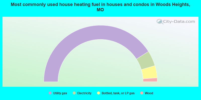
- 82.0%Utility gas
- 8.8%Electricity
- 7.0%Bottled, tank, or LP gas
- 2.2%Wood
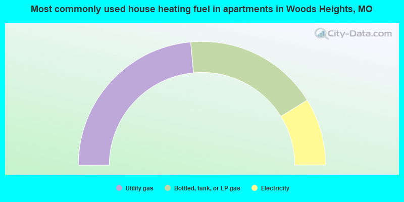
- 47.1%Utility gas
- 35.3%Bottled, tank, or LP gas
- 17.6%Electricity
Woods Heights compared to Missouri state average:
- Unemployed percentage below state average.
- Black race population percentage significantly below state average.
- Hispanic race population percentage below state average.
- Foreign-born population percentage significantly below state average.
- Renting percentage significantly below state average.
- Length of stay since moving in significantly above state average.
- Number of rooms per house significantly below state average.
- House age significantly below state average.
- Number of college students significantly below state average.
- Percentage of population with a bachelor's degree or higher below state average.