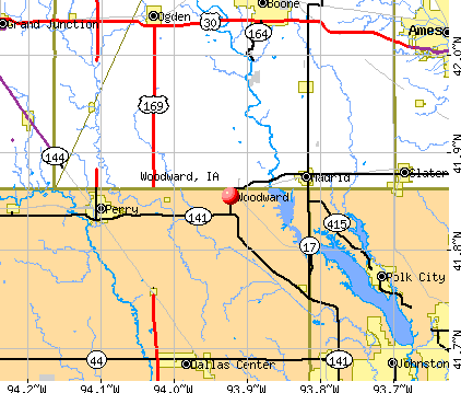
Woodward, Iowa
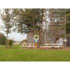
Woodward: Woodward Lions Park

Woodward: Eric Bohling's 107 West 4th Street Christmas Display
- add
your
Submit your own pictures of this city and show them to the world
- OSM Map
- General Map
- Google Map
- MSN Map
Population change since 2000: +13.8%
| Males: 730 | |
| Females: 635 |
| Median resident age: | 41.3 years |
| Iowa median age: | 38.9 years |
Zip codes: 50276.
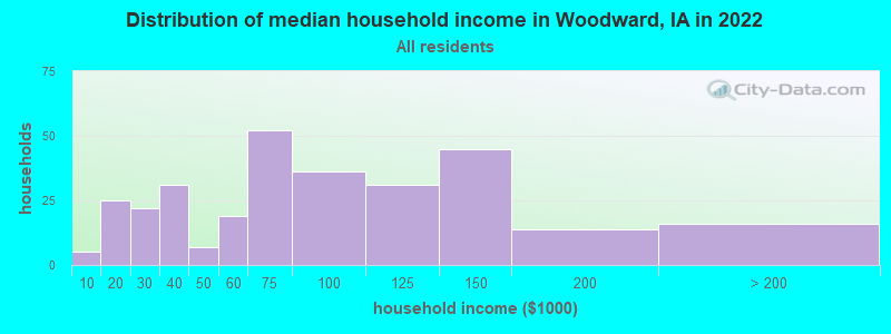
| Woodward: | $69,317 |
| IA: | $69,588 |
Estimated per capita income in 2022: $29,157 (it was $19,501 in 2000)
Woodward city income, earnings, and wages data
Estimated median house or condo value in 2022: $191,146 (it was $67,100 in 2000)
| Woodward: | $191,146 |
| IA: | $194,600 |
Mean prices in 2022: all housing units: $373,151; detached houses: $401,654; townhouses or other attached units: $245,588; in 2-unit structures: $396,325; in 3-to-4-unit structures: $227,384; in 5-or-more-unit structures: $215,989; mobile homes: $83,561
Median gross rent in 2022: $786.
(10.1% for White Non-Hispanic residents, 100.0% for Hispanic or Latino residents)
Detailed information about poverty and poor residents in Woodward, IA
Compare current foreclosures near Woodward, IA:
| Photo | Address | Area | Beds / Baths | Price | Details |
|---|---|---|---|---|---|

|
#1
Monona St
Boone, IA 50036
|
1,239 sq. feet
|
1 baths 3 beds |
$164,500
|
show details |

|
#2
Main St
Boone, IA 50036
|
- sq. feet
|
2 baths 3 beds |
$109,900
|
show details |

|
#3
Mcwilliams Dr
Johnston, IA 50131
|
2,079 sq. feet
|
2 baths 3 beds |
show details | |

|
#4
Cherry St
Dallas Center, IA 50063
|
1,762 sq. feet
|
1 baths 3 beds |
show details | |

|
#5
SE Glenstone Dr Unit 223
Grimes, IA 50111
|
1,712 sq. feet
|
2 baths 2 beds |
show details | |

|
#6
Nottingham Dr
Johnston, IA 50131
|
2,602 sq. feet
|
2 baths 4 beds |
show details | |

|
#7
Prairie Pkwy
Johnston, IA 50131
|
1,739 sq. feet
|
2 baths 2 beds |
show details | |

|
#8
Coburn Ln
Johnston, IA 50131
|
5,559 sq. feet
|
4 baths 4 beds |
show details | |

|
#9
Sutton Dr # 4
Urbandale, IA 50322
|
864 sq. feet
|
1 baths 2 beds |
show details | |

|
#10
SE Little Beaver Dr
Grimes, IA 50111
|
1,334 sq. feet
|
1 baths 3 beds |
show details |
| Photo | Address | Area | Beds / Baths | Price | Details |
|---|---|---|---|---|---|

|
#11
Greenbelt Dr
Urbandale, IA 50323
|
1,056 sq. feet
|
2 baths 2 beds |
show details | |

|
#12
NW Norton Cir
Grimes, IA 50111
|
1,480 sq. feet
|
1 baths 3 beds |
show details | |

|
#13
NW Morningside Ct
Grimes, IA 50111
|
1,614 sq. feet
|
2 baths 3 beds |
show details | |

|
#14
E Madison Dr
Polk City, IA 50226
|
1,040 sq. feet
|
1 baths 3 beds |
show details | |

|
#15
SE Little Beaver Ct
Grimes, IA 50111
|
1,016 sq. feet
|
2 baths 2 beds |
show details | |

|
#16
7th St
Perry, IA 50220
|
1,009 sq. feet
|
1 baths 2 beds |
show details | |

|
#17
Hillcrest Dr
Polk City, IA 50226
|
1,475 sq. feet
|
2 baths 3 beds |
show details | |

|
#18
Warford St
Perry, IA 50220
|
1,980 sq. feet
|
1 baths 4 beds |
show details | |

|
#19
2nd St
Perry, IA 50220
|
2,636 sq. feet
|
1 baths 5 beds |
show details | |

|
#20
W 2nd St
Perry, IA 50220
|
816 sq. feet
|
1 baths 2 beds |
show details |
| Photo | Address | Area | Beds / Baths | Price | Details |
|---|---|---|---|---|---|

|
#21
Pattee St
Perry, IA 50220
|
1,200 sq. feet
|
1 baths 2 beds |
show details | |

|
#22
Otley Ave
Perry, IA 50220
|
1,686 sq. feet
|
2 baths 3 beds |
show details | |

|
#23
Sugar Grove Ave
Dallas Center, IA 50063
|
996 sq. feet
|
1 baths 2 beds |
show details | |

|
#24
NW 5th St
Ankeny, IA 50023
|
1,363 sq. feet
|
2 baths - beds |
show details | |

|
#25
Todd Dr, Unit 103
Ames, IA 50014
|
- sq. feet
|
- baths - beds |
show details | |

|
#26
NE Boston Pkwy, Apt 2314
Waukee, IA 50263
|
- sq. feet
|
- baths - beds |
show details | |

|
#27
NW Lexington Dr
Waukee, IA 50263
|
- sq. feet
|
- baths - beds |
show details | |

|
#28
NW 62nd Ave # 311
Johnston, IA 50131
|
- sq. feet
|
- baths - beds |
show details | |

|
#29
NW Charlestown Ln
Waukee, IA 50263
|
- sq. feet
|
- baths - beds |
show details | |

|
#30
NW Blackberry St
Waukee, IA 50263
|
- sq. feet
|
- baths - beds |
show details |
| Photo | Address | Area | Beds / Baths | Price | Details |
|---|---|---|---|---|---|

|
#31
Alpine Dr
Urbandale, IA 50323
|
- sq. feet
|
- baths - beds |
show details | |

|
#32
NW Applewood St
Ankeny, IA 50023
|
- sq. feet
|
- baths - beds |
show details | |

|
#33
NW Olive St
Waukee, IA 50263
|
- sq. feet
|
- baths - beds |
show details | |

|
#34
NW 20th St
Ankeny, IA 50023
|
- sq. feet
|
- baths - beds |
show details | |

|
#35
Steinbeck St Unit 107
Ames, IA 50014
|
- sq. feet
|
- baths - beds |
show details | |

|
#36
NE Alices Rd, Apt 20
Waukee, IA 50263
|
- sq. feet
|
- baths - beds |
show details | |

|
#37
NE Alices Rd
Waukee, IA 50263
|
- sq. feet
|
- baths - beds |
show details | |

|
#38
Boston Pkwy, Apt 102
Clive, IA 50325
|
- sq. feet
|
- baths - beds |
show details | |

|
#39
NW Rambling Creek Ln Unit 11
Ankeny, IA 50023
|
- sq. feet
|
- baths - beds |
show details | |

|
#40
SW 6th St
Ankeny, IA 50023
|
- sq. feet
|
- baths - beds |
show details |
| Photo | Address | Area | Beds / Baths | Price | Details |
|---|---|---|---|---|---|

|
#41
Meadow Pointe Ct
Alleman, IA 50007
|
- sq. feet
|
- baths - beds |
show details | |

|
#42
NE Horizon Dr, Apt 214
Waukee, IA 50263
|
- sq. feet
|
- baths - beds |
show details | |

|
#43
Tabor Dr
Ames, IA 50014
|
1,494 sq. feet
|
- baths - beds |
show details | |

|
#44
NW Abilene Rd
Ankeny, IA 50023
|
- sq. feet
|
- baths - beds |
show details | |

|
#45
Merle Hay Rd # 308
Johnston, IA 50131
|
- sq. feet
|
- baths - beds |
show details | |

|
#46
NW 20th St
Ankeny, IA 50023
|
- sq. feet
|
- baths - beds |
show details | |

|
#47
W 4th St
Bouton, IA 50039
|
- sq. feet
|
- baths - beds |
show details | |

|
#48
8th St Apt 101
Boone, IA 50036
|
- sq. feet
|
- baths - beds |
show details | |

|
#49
Bobcat Dr, Unit 201
Ames, IA 50014
|
- sq. feet
|
- baths - beds |
show details | |

|
Check over 1 million property listings on Foreclosure.com!
|
browse all offers | |||


- 97391.6%White alone
- 292.7%Black alone
- 242.3%Two or more races
- 232.2%Hispanic
- 90.8%Asian alone
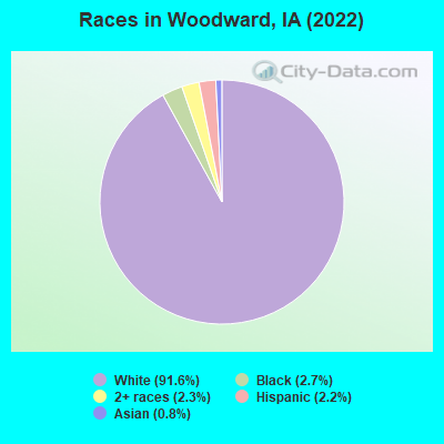
Races in Woodward detailed stats: ancestries, foreign born residents, place of birth
According to our research of Iowa and other state lists, there were 4 registered sex offenders living in Woodward, Iowa as of May 14, 2024.
The ratio of all residents to sex offenders in Woodward is 409 to 1.
The ratio of registered sex offenders to all residents in this city is near the state average.
 Recent articles from our blog. Our writers, many of them Ph.D. graduates or candidates, create easy-to-read articles on a wide variety of topics.

 | Retired and moving out of NJ , thinking of Ankeny (19 replies) |
| Don't move to Des Moines, Iowa unless.. (155 replies) |
| Adair ia (9 replies) |
| Omaha compared to Des Moines (75 replies) |
| May be relocating to Perry, Iowa - husband's job transferring with Tyson (1 reply) |
| Bike Trails in Des Moines Area/Around the state? (10 replies) |
Latest news from Woodward, IA collected exclusively by city-data.com from local newspapers, TV, and radio stations
Ancestries: German (43.7%), American (4.9%), Irish (4.7%), Norwegian (4.2%), European (4.0%), English (2.2%).
Current Local Time: CST time zone
Incorporated on 10/13/1883
Elevation: 1060 feet
Land area: 0.91 square miles.
Population density: 1,500 people per square mile (low).

16 residents are foreign born
| This city: | 1.5% |
| Iowa: | 5.6% |
Median real estate property taxes paid for housing units with mortgages in 2022: $2,898 (1.6%)
Median real estate property taxes paid for housing units with no mortgage in 2022: $3,474 (1.9%)
Nearest city with pop. 50,000+: Ames, IA  (19.1 miles , pop. 50,731).
Nearest city with pop. 200,000+: Omaha, NE (115.7 miles , pop. 390,007).
Nearest city with pop. 1,000,000+: Chicago, IL (321.6 miles , pop. 2,896,016).
Nearest cities:
), )Latitude: 41.86 N, Longitude: 93.92 W
Area code: 515
Single-family new house construction building permits:
- 2022: 6 buildings, average cost: $227,500
- 2021: 7 buildings, average cost: $227,500
- 2020: 7 buildings, average cost: $175,000
- 2019: 3 buildings, average cost: $175,000
- 2018: 3 buildings, average cost: $175,000
- 2017: 1 building, cost: $175,000
- 2016: 1 building, cost: $175,000
- 2015: 1 building, cost: $160,000
- 2014: 2 buildings, average cost: $180,000
- 2007: 2 buildings, average cost: $167,500
- 2006: 15 buildings, average cost: $179,600
- 2005: 1 building, cost: $90,000
- 2004: 1 building, cost: $70,000
- 2002: 3 buildings, average cost: $133,300
- 2001: 1 building, cost: $105,000
- 2000: 2 buildings, average cost: $121,400
- 1999: 1 building, cost: $105,000
- 1998: 1 building, cost: $100,000
- 1997: 3 buildings, average cost: $83,300
| Here: | 2.0% |
| Iowa: | 2.7% |
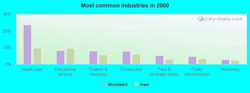
- Health care (23.6%)
- Educational services (8.3%)
- Finance & insurance (8.0%)
- Construction (7.8%)
- Food & beverage stores (5.3%)
- Public administration (4.7%)
- Machinery (2.8%)
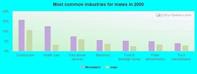
- Construction (15.9%)
- Health care (12.7%)
- Educational services (7.6%)
- Machinery (5.7%)
- Food & beverage stores (5.4%)
- Public administration (5.1%)
- Truck transportation (4.1%)

- Health care (34.2%)
- Finance & insurance (14.2%)
- Educational services (8.9%)
- Food & beverage stores (5.2%)
- Social assistance (4.9%)
- Public administration (4.3%)
- Data processing, libraries, other information services (2.8%)
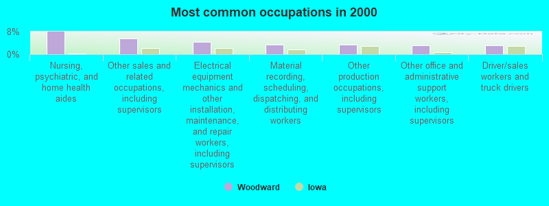
- Nursing, psychiatric, and home health aides (8.0%)
- Other sales and related occupations, including supervisors (5.6%)
- Electrical equipment mechanics and other installation, maintenance, and repair workers, including supervisors (4.4%)
- Material recording, scheduling, dispatching, and distributing workers (3.4%)
- Other production occupations, including supervisors (3.3%)
- Other office and administrative support workers, including supervisors (3.1%)
- Driver/sales workers and truck drivers (3.1%)
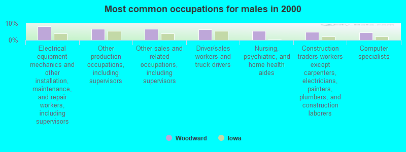
- Electrical equipment mechanics and other installation, maintenance, and repair workers, including supervisors (8.3%)
- Other production occupations, including supervisors (6.7%)
- Other sales and related occupations, including supervisors (6.7%)
- Driver/sales workers and truck drivers (6.3%)
- Nursing, psychiatric, and home health aides (5.4%)
- Construction traders workers except carpenters, electricians, painters, plumbers, and construction laborers (4.8%)
- Computer specialists (4.4%)
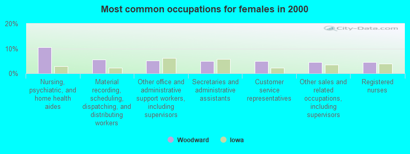
- Nursing, psychiatric, and home health aides (10.5%)
- Material recording, scheduling, dispatching, and distributing workers (5.5%)
- Other office and administrative support workers, including supervisors (5.2%)
- Secretaries and administrative assistants (4.9%)
- Customer service representatives (4.9%)
- Other sales and related occupations, including supervisors (4.6%)
- Registered nurses (4.6%)
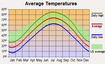
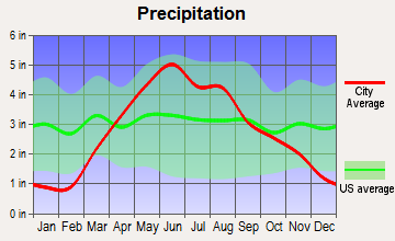
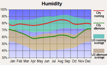
Average climate in Woodward, Iowa
Based on data reported by over 4,000 weather stations
|
|

(lower is better)
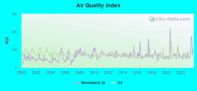
Air Quality Index (AQI) level in 2023 was 97.4. This is worse than average.
| City: | 97.4 |
| U.S.: | 72.6 |
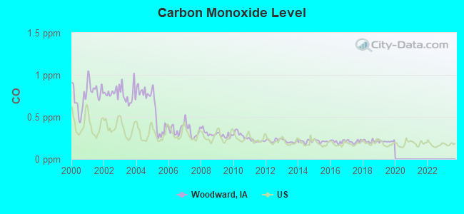
Carbon Monoxide (CO) [ppm] level in 2019 was 0.209. This is better than average. Closest monitor was 17.1 miles away from the city center.
| City: | 0.209 |
| U.S.: | 0.251 |
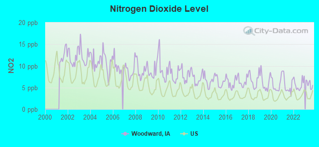
Nitrogen Dioxide (NO2) [ppb] level in 2023 was 5.78. This is about average. Closest monitor was 22.5 miles away from the city center.
| City: | 5.78 |
| U.S.: | 5.11 |
Sulfur Dioxide (SO2) [ppb] level in 2018 was 0.0417. This is significantly better than average. Closest monitor was 18.6 miles away from the city center.
| City: | 0.0417 |
| U.S.: | 1.5147 |
Ozone [ppb] level in 2023 was 36.8. This is about average. Closest monitor was 20.2 miles away from the city center.
| City: | 36.8 |
| U.S.: | 33.3 |
Particulate Matter (PM2.5) [µg/m3] level in 2023 was 10.5. This is worse than average. Closest monitor was 19.6 miles away from the city center.
| City: | 10.5 |
| U.S.: | 8.1 |
Tornado activity:
Woodward-area historical tornado activity is slightly above Iowa state average. It is 113% greater than the overall U.S. average.
On 6/13/1976, a category F5 (max. wind speeds 261-318 mph) tornado 5.8 miles away from the Woodward city center injured 9 people and caused between $5,000,000 and $50,000,000 in damages.
On 4/8/1999, a category F4 (max. wind speeds 207-260 mph) tornado 6.5 miles away from the city center injured one person and caused $2 million in damages.
Earthquake activity:
Woodward-area historical earthquake activity is significantly above Iowa state average. It is 210% greater than the overall U.S. average.On 9/3/2016 at 12:02:44, a magnitude 5.8 (5.8 MW, Depth: 3.5 mi, Class: Moderate, Intensity: VI - VII) earthquake occurred 408.7 miles away from Woodward center
On 4/18/2008 at 09:36:59, a magnitude 5.4 (5.1 MB, 4.8 MS, 5.4 MW, 5.2 MW) earthquake occurred 396.4 miles away from Woodward center
On 11/6/2011 at 03:53:10, a magnitude 5.7 (5.7 MW, Depth: 3.2 mi) earthquake occurred 463.4 miles away from the city center
On 7/9/1975 at 14:54:15, a magnitude 4.6 (4.6 MB, Class: Light, Intensity: IV - V) earthquake occurred 284.2 miles away from Woodward center
On 4/18/2008 at 09:36:59, a magnitude 5.2 (5.2 MW, Depth: 8.9 mi) earthquake occurred 396.4 miles away from Woodward center
On 6/10/1987 at 23:48:54, a magnitude 5.1 (4.9 MB, 4.4 MS, 4.6 MS, 5.1 LG) earthquake occurred 381.1 miles away from Woodward center
Magnitude types: regional Lg-wave magnitude (LG), body-wave magnitude (MB), surface-wave magnitude (MS), moment magnitude (MW)
Natural disasters:
The number of natural disasters in Dallas County (18) is near the US average (15).Major Disasters (Presidential) Declared: 14
Emergencies Declared: 1
Causes of natural disasters: Floods: 12, Storms: 10, Tornadoes: 8, Winds: 3, Hurricane: 1, Ice Storm: 1, Winter Storm: 1, Other: 1 (Note: some incidents may be assigned to more than one category).
Hospitals and medical centers in Woodward:
- WOODWARD RESOURCE CENTER (1251 334TH STREET)
- USA HEALTH CARE CENTER-WOODWARD (706 CEDAR AVENUE PO BOX 430)
Other hospitals and medical centers near Woodward:
- MADRID HOME FOR THE AGED (Nursing Home, about 6 miles away; MADRID, IA)
- ROWLEY MEMORIAL MASONIC HOME (Nursing Home, about 8 miles away; PERRY, IA)
- GRANGER NURSING AND REHABILITATION CENTER (Nursing Home, about 9 miles away; GRANGER, IA)
- PERRY HEALTH CARE CENTER (Nursing Home, about 9 miles away; PERRY, IA)
- PERRY LUTHERAN HOME (Nursing Home, about 9 miles away; PERRY, IA)
- PERRY DIALYSIS (Dialysis Facility, about 9 miles away; PERRY, IA)
- POLK CITY NURSING AND REHABILITATION CENTER (Nursing Home, about 12 miles away; POLK CITY, IA)
Heliports located in Woodward:
Colleges/universities with over 2000 students nearest to Woodward:
- Iowa State University (about 19 miles; Ames, IA; Full-time enrollment: 28,662)
- Des Moines Area Community College (about 20 miles; Ankeny, IA; FT enrollment: 15,337)
- Drake University (about 23 miles; Des Moines, IA; FT enrollment: 3,768)
- Iowa Central Community College (about 47 miles; Fort Dodge, IA; FT enrollment: 4,682)
- Buena Vista University (about 86 miles; Storm Lake, IA; FT enrollment: 2,522)
- University of Northern Iowa (about 88 miles; Cedar Falls, IA; FT enrollment: 10,816)
- Hawkeye Community College (about 91 miles; Waterloo, IA; FT enrollment: 7,160)
Public high schools in Woodward:
- WOODWARD ACADEMY (Students: 268, Location: 1251 334TH ST, Grades: 5-12)
- WOODWARD-GRANGER HIGH SCHOOL (Location: 306 W 3RD ST, Grades: 9-12)
Private high school in Woodward:
- WOODWARD ACADEMY (Students: 268, Location: 1251 334TH ST, Grades: 5-12, Boys only)
Public elementary/middle school in Woodward:
- WOODWARD-GRANGER MIDDLE SCHOOL (Students: 128, Location: 306 W 3RD ST, Grades: 6-8)
Points of interest:
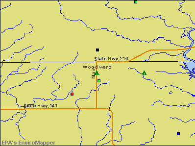
Notable locations in Woodward: Woodward (A), Woodward Community Fire Department (B), Woodward Public Library (C), Woodward City Hall (D). Display/hide their locations on the map
Churches in Woodward include: Christian Church (A), United Methodist Church (B), Assembly of God Church (C). Display/hide their locations on the map
| This city: | 2.2 people |
| Iowa: | 2.4 people |
| This city: | 60.2% |
| Whole state: | 64.7% |
| This city: | 8.4% |
| Whole state: | 6.7% |
Likely homosexual households (counted as self-reported same-sex unmarried-partner households)
- Lesbian couples: 0.9% of all households
- Gay men: 0.0% of all households
Banks with branches in Woodward (2011 data):
- Earlham Savings Bank: Woodward Branch at 217 South Main Street, branch established on 2010/12/01. Info updated 2009/04/24: Bank assets: $268.2 mil, Deposits: $229.9 mil, headquarters in West Des Moines, IA, positive income, Commercial Lending Specialization, 7 total offices
For population 15 years and over in Woodward:
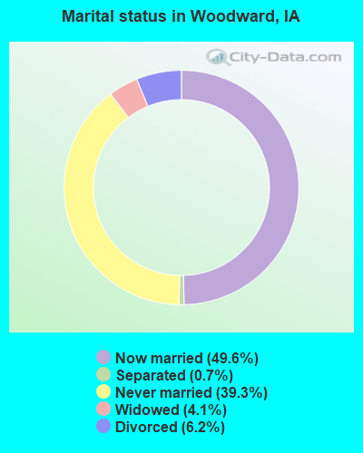
- Never married: 39.3%
- Now married: 49.6%
- Separated: 0.7%
- Widowed: 4.1%
- Divorced: 6.2%
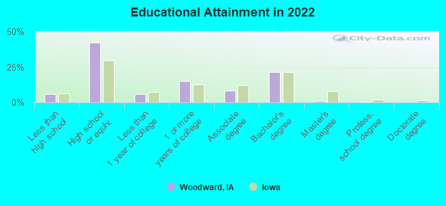
For population 25 years and over in Woodward:
- High school or higher: 93.3%
- Bachelor's degree or higher: 20.5%
- Graduate or professional degree: 1.3%
- Unemployed: 3.8%
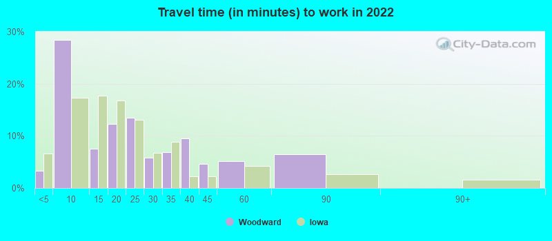
- Mean travel time to work (commute): 24.7 minutes
| Here: | 8.4 |
| Iowa average: | 10.5 |
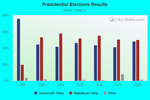
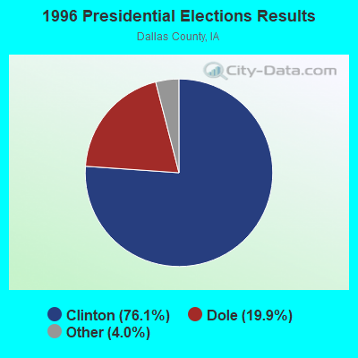
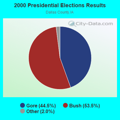
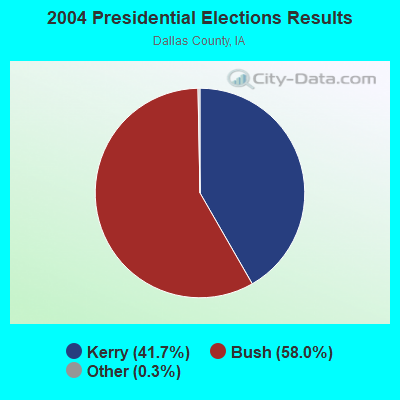
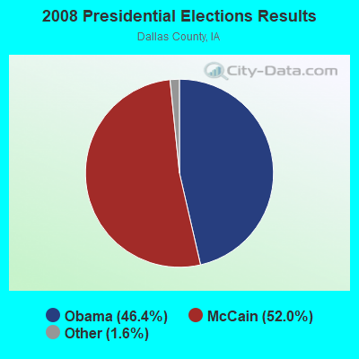
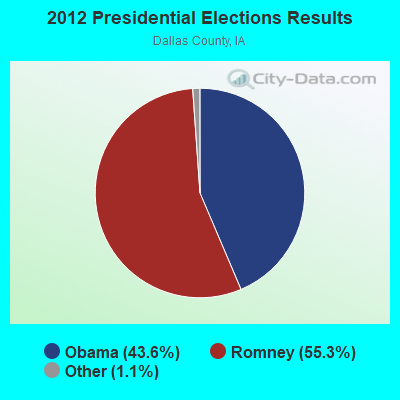
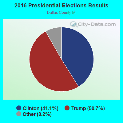
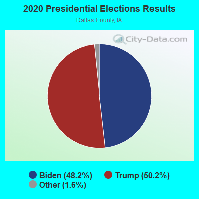
Graphs represent county-level data. Detailed 2008 Election Results
Religion statistics for Woodward, IA (based on Dallas County data)
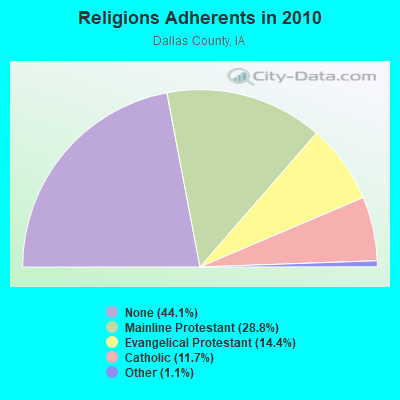
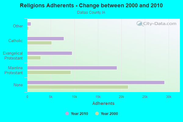
| Religion | Adherents | Congregations |
|---|---|---|
| Mainline Protestant | 19,020 | 34 |
| Evangelical Protestant | 9,492 | 37 |
| Catholic | 7,733 | 4 |
| Other | 747 | 5 |
| None | 29,143 | - |
Food Environment Statistics:
| Dallas County: | 1.57 / 10,000 pop. |
| State: | 2.14 / 10,000 pop. |
| Here: | 0.17 / 10,000 pop. |
| Iowa: | 0.23 / 10,000 pop. |
| This county: | 8.22 / 10,000 pop. |
| Iowa: | 5.55 / 10,000 pop. |
| Dallas County: | 7.87 / 10,000 pop. |
| State: | 8.01 / 10,000 pop. |
| Dallas County: | 6.5% |
| Iowa: | 7.8% |
| Here: | 28.0% |
| Iowa: | 27.3% |
| Dallas County: | 17.1% |
| State: | 14.5% |
Health and Nutrition:
| Here: | 48.4% |
| State: | 49.5% |
| Woodward: | 43.4% |
| Iowa: | 46.1% |
| Woodward: | 28.8 |
| State: | 28.6 |
| Woodward: | 20.4% |
| Iowa: | 21.4% |
| Here: | 7.0% |
| Iowa: | 10.4% |
| Woodward: | 6.7 |
| Iowa: | 6.8 |
| Woodward: | 27.8% |
| Iowa: | 33.8% |
| Woodward: | 58.3% |
| Iowa: | 55.9% |
| Woodward: | 76.0% |
| State: | 77.7% |
More about Health and Nutrition of Woodward, IA Residents
| Local government employment and payroll (March 2022) | |||||
| Function | Full-time employees | Monthly full-time payroll | Average yearly full-time wage | Part-time employees | Monthly part-time payroll |
|---|---|---|---|---|---|
| Sewerage | 1 | $6,181 | $74,172 | 0 | $0 |
| Financial Administration | 1 | $4,076 | $48,912 | 1 | $927 |
| Streets and Highways | 1 | $4,574 | $54,888 | 0 | $0 |
| Local Libraries | 1 | $6,154 | $73,848 | 2 | $1,267 |
| Police Protection - Officers | 1 | $4,684 | $56,208 | 1 | $292 |
| Water Supply | 1 | $7,246 | $86,952 | 0 | $0 |
| Totals for Government | 6 | $32,915 | $65,830 | 4 | $2,486 |
Woodward government finances - Expenditure in 2017 (per resident):
- Construction - Regular Highways: $483,000 ($353.85)
General - Other: $82,000 ($60.07)
- Current Operations - Water Utilities: $295,000 ($216.12)
Regular Highways: $248,000 ($181.68)
Sewerage: $231,000 ($169.23)
Solid Waste Management: $107,000 ($78.39)
Financial Administration: $101,000 ($73.99)
Police Protection: $95,000 ($69.60)
Libraries: $74,000 ($54.21)
Parks and Recreation: $23,000 ($16.85)
General - Other: $19,000 ($13.92)
Local Fire Protection: $17,000 ($12.45)
Central Staff Services: $15,000 ($10.99)
Health - Other: $12,000 ($8.79)
Judicial and Legal Services: $7,000 ($5.13)
General Public Buildings: $4,000 ($2.93)
Miscellaneous Commercial Activities - Other: $1,000 ($0.73)
- General - Interest on Debt: $123,000 ($90.11)
- Intergovernmental to Local - Other - General - Other: $108,000 ($79.12)
- Total Salaries and Wages: $340,000 ($249.08)
- Water Utilities - Interest on Debt: $58,000 ($42.49)
Woodward government finances - Revenue in 2017 (per resident):
- Charges - Sewerage: $252,000 ($184.62)
Solid Waste Management: $76,000 ($55.68)
Other: $9,000 ($6.59)
- Local Intergovernmental - Other: $7,000 ($5.13)
- Miscellaneous - General Revenue - Other: $13,000 ($9.52)
Interest Earnings: $3,000 ($2.20)
Rents: $2,000 ($1.47)
Fines and Forfeits: $1,000 ($0.73)
Sale of Property: $1,000 ($0.73)
- Revenue - Water Utilities: $333,000 ($243.96)
- State Intergovernmental - Highways: $182,000 ($133.33)
General Local Government Support: $12,000 ($8.79)
Other: $2,000 ($1.47)
- Tax - Property: $497,000 ($364.10)
Public Utilities Sales: $14,000 ($10.26)
Other License: $7,000 ($5.13)
Woodward government finances - Debt in 2017 (per resident):
- Long Term Debt - Beginning Outstanding - Unspecified Public Purpose: $5,614,000 ($4112.82)
Outstanding Unspecified Public Purpose: $5,386,000 ($3945.79)
Retired Unspecified Public Purpose: $228,000 ($167.03)
Woodward government finances - Cash and Securities in 2017 (per resident):
- Other Funds - Cash and Securities: $1,081,000 ($791.94)
Strongest AM radio stations in Woodward:
- WHO (1040 AM; 50 kW; DES MOINES, IA; Owner: CITICASTERS LICENSES, L.P.)
- WOI (640 AM; 5 kW; AMES, IA; Owner: IOWA STATE UNIV., OF SCIENCE & TECH.)
- KFGQ (1260 AM; 5 kW; BOONE, IA; Owner: BOONE BIBLICAL MINISTRIES, INC.)
- KDLS (1310 AM; 0 kW; PERRY, IA; Owner: PERRY BROADCASTING COMPANY)
- KBGG (1700 AM; 10 kW; DES MOINES, IA; Owner: CITADEL BROADCASTING COMPANY)
- KPSZ (940 AM; 10 kW; DES MOINES, IA; Owner: SAGA COMMUNICATIONS OF IOWA, LLC)
- KXNO (1460 AM; 5 kW; DES MOINES, IA; Owner: CAPSTAR TX LIMITED PARTNERSHIP)
- KRNT (1350 AM; 5 kW; DES MOINES, IA; Owner: SAGA COMMUNICATIONS OF IOWA, LLC)
- KWBG (1590 AM; 1 kW; BOONE, IA; Owner: WMMP, LLC)
- KXEL (1540 AM; 50 kW; WATERLOO, IA; Owner: KXEL BROADCASTING COMPANY, INC.)
- KWMT (540 AM; 5 kW; FORT DODGE, IA; Owner: CLEAR CHANNEL BROADCASTING LICENSES, INC.)
- KOIL (1020 AM; 50 kW; PLATTSMOUTH, NE; Owner: WAITT RADIO, INC.)
- KFAB (1110 AM; 50 kW; OMAHA, NE; Owner: CAPSTAR TX LIMITED PARTNERSHIP)
Strongest FM radio stations in Woodward:
- KLTI-FM (104.1 FM; AMES, IA; Owner: SAGA COMMUNICATIONS OF IOWA, LLC)
- KMXD (100.3 FM; DES MOINES, IA; Owner: CITICASTERS LICENSES, L.P.)
- WOI-FM (90.1 FM; AMES, IA; Owner: IOWA STATE UNIVERSITY OF SCI & TECH)
- KSTZ (102.5 FM; DES MOINES, IA; Owner: SAGA COMMUNICATIONS OF IOWA, LLC)
- KDLS-FM (105.5 FM; PERRY, IA; Owner: PERRY BROADCASTING COMPANY)
- KRKQ (98.3 FM; BOONE, IA; Owner: CITADEL BROADCASTING COMPANY)
- KLRX (96.1 FM; MADRID, IA; Owner: THOMAS H. BURKE, RECEIVER FOR LIFESTYLE COMMUNICATIONS CORP.)
- KIOA (93.3 FM; DES MOINES, IA; Owner: SAGA COMMUNICATIONS OF IOWA, LLC)
- KJJY (92.5 FM; WEST DES MOINES, IA; Owner: CITADEL BROADCASTING COMPANY)
- KGGO (94.9 FM; DES MOINES, IA; Owner: CITADEL BROADCASTING COMPANY)
- KHKI (97.3 FM; DES MOINES, IA; Owner: CITADEL BROADCASTING COMPANY)
- KFGQ-FM (99.3 FM; BOONE, IA; Owner: BOONE BIBLICAL MINISTRIES, INC.)
- KAZR (103.3 FM; PELLA, IA; Owner: SAGA COMMUNICATIONS OF IOWA, LLC)
- KCCQ (105.1 FM; AMES, IA; Owner: CITICASTERS LICENSES, L.P.)
- KKDM (107.5 FM; DES MOINES, IA; Owner: CLEAR CHANNEL BROADCASTING LICENSES, INC.)
- KVJZ (106.3 FM; ANKENY, IA; Owner: CITICASTERS LICENSES, L.P.)
- KDFR (91.3 FM; DES MOINES, IA; Owner: FAMILY STATIONS, INC.)
- KJMC (89.3 FM; DES MOINES, IA; Owner: MINORITY COMMUNICATIONS, INC.)
- KKRF (107.9 FM; STUART, IA; Owner: COON VALLEY COMMUNICATIONS, INC.)
- K269EJ (101.7 FM; DES MOINES, IA; Owner: UNIVERSITY OF NORTHERN IOWA)
TV broadcast stations around Woodward:
- KDIN-TV (Channel 11; DES MOINES, IA; Owner: IOWA PUBLIC BROADCASTING BOARD)
- WOI-TV (Channel 5; AMES, IA; Owner: CAPITAL COMMUNICATIONS COMPANY, INC.)
- WHO-TV (Channel 13; DES MOINES, IA; Owner: NEW YORK TIMES MANAGEMENT SERVICES)
- KCCI (Channel 8; DES MOINES, IA; Owner: DES MOINES HEARST-ARGYLE TV, INC.)
- KPWB-TV (Channel 23; AMES, IA; Owner: PAPPAS TELECASTING OF IOWA, L.L.C.)
- KDSM-TV (Channel 17; DES MOINES, IA; Owner: KDSM LICENSEE, LLC)
- K56GD (Channel 56; AMES, IA; Owner: TV-45, INC.)
- K48FZ (Channel 48; AMES, IA; Owner: TV-52, INC.)
- WBXF-CA (Channel 4; DES MOINES, IA; Owner: THE BOX WORLDWIDE LLC)
- K41DD (Channel 41; DES MOINES, IA; Owner: VENTANA TELEVISION, INC.)
- KRPG-LP (Channel 43; DES MOINES, IA; Owner: TIGER EYE BROADCASTING CORPORATION)
- K29EA (Channel 29; DES MOINES, IA; Owner: TV-45, INC.)
- National Bridge Inventory (NBI) Statistics
- 13Number of bridges
- 164ft / 49.5mTotal length
- 16,839Total average daily traffic
- 1,270Total average daily truck traffic
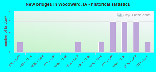
- New bridges - historical statistics
- 11900-1909
- 11950-1959
- 11970-1979
- 31980-1989
- 31990-1999
- 32000-2009
- 12010-2019
FCC Registered Cell Phone Towers:
1 (See the full list of FCC Registered Cell Phone Towers in Woodward)FCC Registered Antenna Towers:
15 (See the full list of FCC Registered Antenna Towers)FCC Registered Broadcast Land Mobile Towers:
4- Woodward State Hospital (Lat: 41.870528 Lon: -93.918556), Call Sign: KNAB308,
Assigned Frequencies: 154.995 MHz, Grant Date: 08/03/2005, Expiration Date: 10/31/2015, Cancellation Date: 01/09/2012, Registrant: Iowa State Patrol Communications, 5912 2nd Avenue, Des Moines, IA 50313, Phone: (515) 281-3175, Fax: (515) 281-6761, Email:
- N Edge State Hospital (Lat: 41.884139 Lon: -93.919944), Type: Tower, Structure height: 91 m, Call Sign: KUV796,
Assigned Frequencies: 155.640 MHz, 155.790 MHz, Grant Date: 05/09/2015, Expiration Date: 07/18/2025, Registrant: Iowa State Patrol Communications, 5912 2nd Ave, Des Moines, IA 50313, Phone: (515) 281-3175, Fax: (515) 281-6761, Email:
- 119 S Main (Lat: 41.871361 Lon: -93.951056), Call Sign: KNGD962,
Assigned Frequencies: 173.337 MHz, Grant Date: 01/14/2003, Expiration Date: 03/23/2013, Cancellation Date: 05/25/2013, Registrant: Xenia Rural Water District, 23998-141st Street, Bouton, IA 50039, Phone: (515) 676-2117, Fax: (515) 676-2208, Email:
- WOODWARD TOWER, Woodward Tank L Ave & 335th Street (Lat: 41.863306 Lon: -93.952306), Type: Tank, Structure height: 36.5 m, Call Sign: WRJT456,
Assigned Frequencies: 173.390 MHz, Grant Date: 10/23/2020, Expiration Date: 10/23/2030, Certifier: Dominic Hayden, Registrant: Micro-Comm, Inc, 15895 S Pflumm Rd, Olathe, KS 66062-8502, Phone: (191) 339-0450, Email:
FCC Registered Microwave Towers:
7- STATION, 3rd St & Rail St (Lat: 41.858583 Lon: -93.919944), Structure height: 48.2 m, Overall height: 50.9 m, Call Sign: WNEZ893,
Assigned Frequencies: 2137.20 MHz, 2143.60 MHz, Grant Date: 10/13/1994, Expiration Date: 10/13/1999, Cancellation Date: 01/15/2000, Phone: (515) 689-3574
- WOODWARD, 1369 Seminole (Lat: 41.839556 Lon: -93.923083), Type: Tower, Structure height: 76.2 m, Overall height: 80.7 m, Call Sign: WPVS594,
Assigned Frequencies: 10618.1 MHz, 11285.0 MHz, Grant Date: 08/14/2012, Expiration Date: 08/12/2022, Cancellation Date: 10/12/2012, Certifier: Steven T Campbell, Registrant: Holland & Knight LLP, 800 17th Street, N.W., Suite #1100, Washington, DC 20006-3906, Phone: (202) 955-3000, Fax: (202) 955-5564, Email:
- Woodward, Country Road, Route #26; 2 Miles Nne (Lat: 41.902500 Lon: -93.904444), Type: Gtower, Structure height: 312.3 m, Overall height: 313.2 m, Call Sign: WQQH336,
Assigned Frequencies: 11445.0 MHz, Grant Date: 12/03/2022, Expiration Date: 12/11/2032, Certifier: Ron Fehr, Registrant: Boone County, Ia, Sheriff Communications, 1019 W Mamie Eisenhower Ave, Boone, IA 50036, Phone: (515) 433-4788, Fax: (515) 432-8047, Email:
- Woodard, 100ft Ene Of 110 Railroad Street (Lat: 41.858444 Lon: -93.919861), Type: Building, Structure height: 59.4 m, Overall height: 61 m, Call Sign: WQTJ845,
Assigned Frequencies: 6152.75 MHz, 6093.45 MHz, 6152.75 MHz, 6093.45 MHz, 6152.75 MHz, 6093.45 MHz, 6152.75 MHz, 6093.45 MHz, 6152.75 MHz, 6093.45 MHz... (+6 more), Grant Date: 02/19/2014, Expiration Date: 02/19/2024, Certifier: Chuck Pauk, Registrant: West Central Cooperative, 213 Se 16th St, Pella, IA 50219, Phone: (641) 628-1724, Fax: (641) 628-4808, Email:
- WOODWARD, N Edge State Hospital (Lat: 41.884167 Lon: -93.920000), Type: Gtower, Structure height: 81 m, Call Sign: WQYM248, Licensee ID: L00004535,
Assigned Frequencies: 6063.80 MHz, Grant Date: 11/03/2016, Expiration Date: 11/03/2026, Certifier: Terry Mcclannahan, Registrant: Dallas County Sheriffs Dept, 25747 N Ave Ste E, Adel, IA 50003, Phone: (575) 993-6937, Email:
- WOODWARD, N Edge State Hospital (Lat: 41.884167 Lon: -93.920000), Type: Gtower, Structure height: 81 m, Call Sign: WRCC569, Licensee ID: L00022233,
Assigned Frequencies: 5974.85 MHz, Grant Date: 08/27/2018, Expiration Date: 08/27/2028, Certifier: Robert Kieffer, Registrant: County Of Boone, 1019 W. Maime Eisenhower Ave, Boone, IA 50036, Phone: (515) 433-0524, Fax: (515) 433-0942, Email:
- WOODWARD, N Edge State Hospital (Lat: 41.884167 Lon: -93.920000), Type: Gtower, Structure height: 81 m, Call Sign: WRCG853, Licensee ID: L00026454,
Assigned Frequencies: 6004.50 MHz, 6152.75 MHz, 6625.00 MHz, Grant Date: 09/27/2018, Expiration Date: 09/27/2028, Certifier: Heath Hove, Registrant: State Of Iowa, 215 East 7th St, Des Moines, IA 50319, Phone: (515) 725-6234, Email:
FCC Registered Amateur Radio Licenses:
8 (See the full list of FCC Registered Amateur Radio Licenses in Woodward)FAA Registered Aircraft:
3- Aircraft: BALLOON WORKS FIREFLY 7B-15 (Category: Land, Weight: Up to 12,499 Pounds), Engine: None
N-Number: 25592, N25592, N-25592, Serial Number: F7B-332, Year manufactured: 1992, Airworthiness Date: 03/26/1992, Certificate Issue Date: 04/14/2012
Registrant (Individual): Zane Kg Mcglade, 506 E 3rd St, Woodward, IA 50276 - Aircraft: CESSNA 177 (Category: Land, Seats: 4, Weight: Up to 12,499 Pounds, Speed: 108 mph), Engine: LYCOMING 0-320 SERIES (180 HP) (Reciprocating)
N-Number: 2829X, N2829X, N-2829X, Serial Number: 17700229, Year manufactured: 1967, Airworthiness Date: 11/08/1967, Certificate Issue Date: 11/06/2018
Registrant (Individual): Joseph Vignaroli, 29376 190th St, Woodward, IA 50276 - Aircraft: SCOTTISH AVIATION BULLDOG 120 (Category: Land, Seats: 3, Weight: Up to 12,499 Pounds), Engine: LYCOMING AEIO-360 SER (180 HP) (Reciprocating)
N-Number: 9875N, N9875N, N-9875N, Serial Number: BH-120-379, Year manufactured: 1976, Airworthiness Date: 10/14/2005, Certificate Issue Date: 01/28/2013
Registrant (LLC): Bulldog Pilots Association LLC, 806 S Main St, Woodward, IA 50276
| Home Mortgage Disclosure Act Aggregated Statistics For Year 2009 (Based on 1 partial tract) | ||
| C) Refinancings | ||
|---|---|---|
| Number | Average Value | |
| LOANS ORIGINATED | 1 | $226,140 |
| APPLICATIONS APPROVED, NOT ACCEPTED | 0 | $0 |
| APPLICATIONS DENIED | 0 | $0 |
| APPLICATIONS WITHDRAWN | 0 | $0 |
| FILES CLOSED FOR INCOMPLETENESS | 0 | $0 |
Detailed HMDA statistics for the following Tracts: 0501.00
| Most common first names in Woodward, IA among deceased individuals | ||
| Name | Count | Lived (average) |
|---|---|---|
| William | 26 | 75.0 years |
| Mary | 21 | 74.8 years |
| John | 20 | 75.3 years |
| Charles | 14 | 69.7 years |
| James | 13 | 67.9 years |
| Edward | 12 | 70.4 years |
| Robert | 11 | 72.9 years |
| Dorothy | 10 | 79.4 years |
| Ralph | 9 | 79.4 years |
| Donald | 8 | 70.5 years |
| Most common last names in Woodward, IA among deceased individuals | ||
| Last name | Count | Lived (average) |
|---|---|---|
| Smith | 10 | 70.3 years |
| Seeman | 8 | 80.2 years |
| Williams | 7 | 64.0 years |
| Rothfus | 7 | 80.2 years |
| Noland | 7 | 79.8 years |
| Moore | 6 | 77.5 years |
| Lincoln | 6 | 77.0 years |
| Rhoads | 6 | 79.2 years |
| Davis | 6 | 80.9 years |
| Burkhart | 6 | 76.5 years |
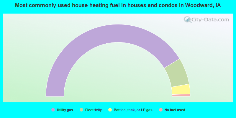
- 82.5%Utility gas
- 12.0%Electricity
- 4.4%Bottled, tank, or LP gas
- 1.1%No fuel used
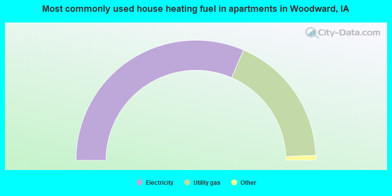
- 63.8%Electricity
- 36.2%Utility gas
Woodward compared to Iowa state average:
- Unemployed percentage significantly below state average.
- Hispanic race population percentage significantly below state average.
- Foreign-born population percentage significantly below state average.
- Length of stay since moving in significantly above state average.

|
Total of 10 patent applications in 2008-2024.