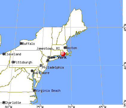
Jamestown, Rhode Island
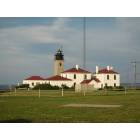
Jamestown: beavertail lighthouse
Jamestown: beavertail state park
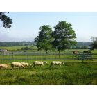
Jamestown: Farm near Marsh Meadows
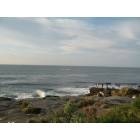
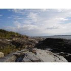
Jamestown: A Rocky intertidal beach at Beavertail park
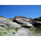
Jamestown: beavertail

Jamestown: beavertail

Jamestown: Clingstone and Bull Point
- add
your
Submit your own pictures of this town and show them to the world
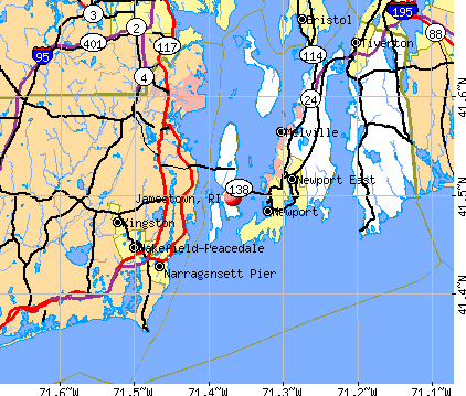
- OSM Map
- General Map
- Google Map
- MSN Map
Population change since 2000: -3.9%
 |
| Males: 2,686 | |
| Females: 2,719 |
| Median resident age: | 50.7 years |
| Rhode Island median age: | 42.3 years |
Zip codes: 02835.
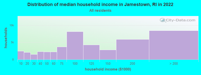
| Jamestown: | $116,692 |
| RI: | $81,854 |
Estimated per capita income in 2022: $89,196 (it was $38,664 in 2000)
Jamestown town income, earnings, and wages data
Estimated median house or condo value in 2022: $826,360 (it was $218,400 in 2000)
| Jamestown: | $826,360 |
| RI: | $383,900 |
Mean prices in 2022: all housing units: $710,652; detached houses: $747,091; townhouses or other attached units: $631,453; in 2-unit structures: $700,569; in 3-to-4-unit structures: $427,450; in 5-or-more-unit structures: $641,305; mobile homes: $94,439
Detailed information about poverty and poor residents in Jamestown, RI


- 5,14995.3%White alone
- 921.7%Two or more races
- 921.7%Hispanic
- 320.6%Asian alone
- 240.4%Black alone
- 80.1%American Indian alone
- 60.1%Other race alone
- 20.04%Native Hawaiian and Other
Pacific Islander alone
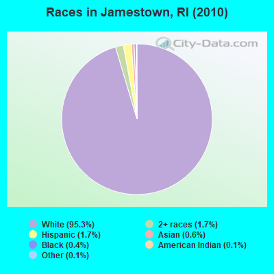
Races in Jamestown detailed stats: ancestries, foreign born residents, place of birth
According to our research of Rhode Island and other state lists, there was 1 registered sex offender living in Jamestown, Rhode Island as of June 07, 2024.
The ratio of all residents to sex offenders in Jamestown is 5,405 to 1.
The ratio of registered sex offenders to all residents in this city is much lower than the state average.
Type |
2009 |
2010 |
2011 |
2012 |
2013 |
2014 |
2015 |
2016 |
2017 |
2018 |
2019 |
2020 |
2021 |
2022 |
|---|---|---|---|---|---|---|---|---|---|---|---|---|---|---|
| Murders (per 100,000) | 0 (0.0) | 0 (0.0) | 0 (0.0) | 0 (0.0) | 0 (0.0) | 0 (0.0) | 0 (0.0) | 0 (0.0) | 0 (0.0) | 0 (0.0) | 0 (0.0) | 0 (0.0) | 0 (0.0) | 0 (0.0) |
| Rapes (per 100,000) | 2 (36.6) | 2 (37.0) | 0 (0.0) | 0 (0.0) | 1 (18.4) | 0 (0.0) | 0 (0.0) | 1 (18.2) | 1 (18.2) | 0 (0.0) | 2 (36.3) | 3 (54.6) | 0 (0.0) | 0 (0.0) |
| Robberies (per 100,000) | 0 (0.0) | 0 (0.0) | 0 (0.0) | 0 (0.0) | 0 (0.0) | 0 (0.0) | 0 (0.0) | 0 (0.0) | 0 (0.0) | 0 (0.0) | 0 (0.0) | 0 (0.0) | 0 (0.0) | 0 (0.0) |
| Assaults (per 100,000) | 1 (18.3) | 3 (55.5) | 2 (37.0) | 2 (37.1) | 0 (0.0) | 2 (36.3) | 0 (0.0) | 0 (0.0) | 7 (127.7) | 3 (54.2) | 2 (36.3) | 0 (0.0) | 0 (0.0) | 1 (18.0) |
| Burglaries (per 100,000) | 13 (237.8) | 12 (222.0) | 14 (259.3) | 8 (148.5) | 5 (91.9) | 10 (181.6) | 12 (218.4) | 4 (72.8) | 5 (91.2) | 11 (198.7) | 2 (36.3) | 3 (54.6) | 2 (35.2) | 5 (90.2) |
| Thefts (per 100,000) | 84 (1,536) | 61 (1,129) | 107 (1,982) | 83 (1,541) | 50 (918.8) | 36 (653.6) | 39 (709.9) | 32 (582.5) | 19 (346.5) | 58 (1,047) | 21 (381.3) | 17 (309.5) | 24 (422.0) | 16 (288.5) |
| Auto thefts (per 100,000) | 4 (73.2) | 1 (18.5) | 4 (74.1) | 2 (37.1) | 0 (0.0) | 2 (36.3) | 0 (0.0) | 0 (0.0) | 1 (18.2) | 7 (126.4) | 1 (18.2) | 0 (0.0) | 2 (35.2) | 2 (36.1) |
| Arson (per 100,000) | 1 (18.3) | 2 (37.0) | 1 (18.5) | 0 (0.0) | 0 (0.0) | 0 (0.0) | 0 (0.0) | 0 (0.0) | 0 (0.0) | 0 (0.0) | 0 (0.0) | 0 (0.0) | 1 (17.6) | 0 (0.0) |
| City-Data.com crime index | 116.9 | 102.9 | 110.8 | 82.4 | 57.9 | 49.0 | 43.7 | 43.0 | 61.8 | 76.8 | 55.6 | 59.9 | 22.2 | 24.3 |
The City-Data.com crime index weighs serious crimes and violent crimes more heavily. Higher means more crime, U.S. average is 246.1. It adjusts for the number of visitors and daily workers commuting into cities.
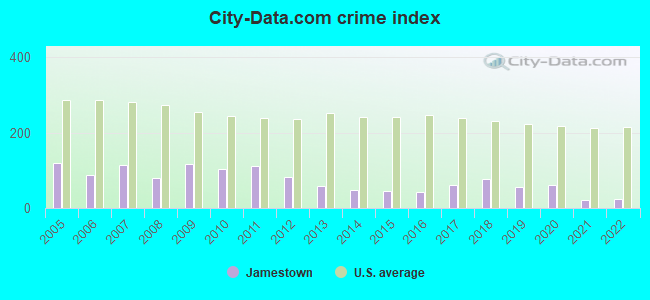
Crime rate in Jamestown detailed stats: murders, rapes, robberies, assaults, burglaries, thefts, arson
Full-time law enforcement employees in 2021, including police officers: 19 (14 officers - 12 male; 2 female).
| Officers per 1,000 residents here: | 2.46 |
| Rhode Island average: | 2.27 |
 Recent articles from our blog. Our writers, many of them Ph.D. graduates or candidates, create easy-to-read articles on a wide variety of topics.

 | Macy's leaving the Providence Place Mall? (190 replies) |
| Providence General Crime Thread (All Posts Go Here) (3036 replies) |
| Jamestown (121 replies) |
| Latest in the Providence restaurant scene (91 replies) |
| Providence plaugued by unenforced noise violations, Elmwood being the epicenter (153 replies) |
| Report: RI remains inundated with illegal guns (220 replies) |
Latest news from Jamestown, RI collected exclusively by city-data.com from local newspapers, TV, and radio stations
Ancestries: Irish (26.0%), English (18.1%), Italian (16.1%), German (9.0%), French (7.1%), Portuguese (6.0%).
Current Local Time: EST time zone
Incorporated in 1678
Elevation: 50 feet
Land area: 9.69 square miles.
Population density: 558 people per square mile (low).
236 residents are foreign born (2.2% Europe, 1.0% Latin America, 0.7% North America).
| This town: | 4.2% |
| Rhode Island: | 11.4% |
| Jamestown town: | 1.2% ($2,649) |
| Rhode Island: | 1.9% ($2,507) |
Nearest city with pop. 50,000+: Warwick, RI  (13.9 miles , pop. 85,808).
Nearest city with pop. 200,000+: Boston, MA (57.3 miles , pop. 589,141).
Nearest city with pop. 1,000,000+: Bronx, NY (138.3 miles , pop. 1,332,650).
Nearest cities:
), Latitude: 41.52 N, Longitude: 71.37 W
Area code: 401

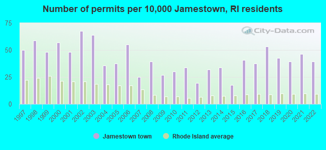
Single-family new house construction building permits:
- 2022: 22 buildings, average cost: $578,200
- 2021: 26 buildings, average cost: $603,500
- 2020: 22 buildings, average cost: $492,000
- 2019: 24 buildings, average cost: $854,300
- 2018: 30 buildings, average cost: $504,300
- 2017: 21 buildings, average cost: $553,800
- 2016: 23 buildings, average cost: $338,100
- 2015: 10 buildings, average cost: $304,300
- 2014: 19 buildings, average cost: $469,900
- 2013: 18 buildings, average cost: $323,600
- 2012: 11 buildings, average cost: $393,300
- 2011: 19 buildings, average cost: $375,200
- 2010: 17 buildings, average cost: $305,400
- 2009: 15 buildings, average cost: $256,700
- 2008: 22 buildings, average cost: $507,600
- 2007: 14 buildings, average cost: $519,500
- 2006: 31 buildings, average cost: $287,700
- 2005: 21 buildings, average cost: $345,000
- 2004: 20 buildings, average cost: $424,300
- 2003: 36 buildings, average cost: $272,200
- 2002: 38 buildings, average cost: $331,800
- 2001: 27 buildings, average cost: $280,300
- 2000: 32 buildings, average cost: $243,000
- 1999: 27 buildings, average cost: $188,100
- 1998: 33 buildings, average cost: $179,600
- 1997: 28 buildings, average cost: $180,500

| Here: | 2.3% |
| Rhode Island: | 3.3% |
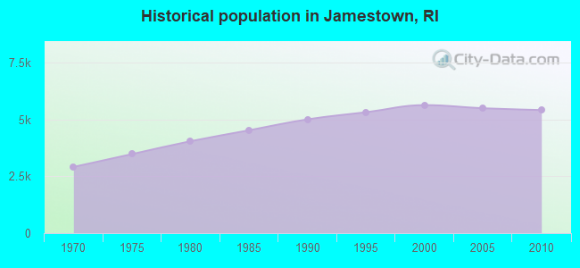
Population change in the 1990s: +606 (+12.1%).
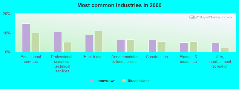
- Educational services (14.9%)
- Professional, scientific, technical services (10.6%)
- Health care (8.8%)
- Accommodation & food services (6.3%)
- Construction (6.2%)
- Finance & insurance (4.9%)
- Arts, entertainment, recreation (4.7%)
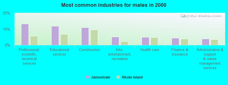
- Professional, scientific, technical services (13.3%)
- Educational services (11.8%)
- Construction (10.9%)
- Arts, entertainment, recreation (5.2%)
- Health care (5.0%)
- Finance & insurance (4.4%)
- Administrative & support & waste management services (4.0%)
- Educational services (18.2%)
- Health care (12.9%)
- Accommodation & food services (8.8%)
- Professional, scientific, technical services (7.7%)
- Public administration (6.2%)
- Finance & insurance (5.5%)
- Arts, entertainment, recreation (4.3%)
- Other management occupations, except farmers and farm managers (7.4%)
- Retail sales workers, except cashiers (5.0%)
- Other office and administrative support workers, including supervisors (4.3%)
- Other sales and related occupations, including supervisors (3.8%)
- Sales representatives, services, wholesale and manufacturing (3.7%)
- Engineers (3.6%)
- Preschool, kindergarten, elementary, and middle school teachers (3.5%)
- Sales representatives, services, wholesale and manufacturing (6.3%)
- Engineers (5.8%)
- Top executives (5.7%)
- Other management occupations, except farmers and farm managers (5.3%)
- Building and grounds cleaning and maintenance occupations (4.2%)
- Electrical equipment mechanics and other installation, maintenance, and repair workers, including supervisors (3.6%)
- Retail sales workers, except cashiers (3.4%)
- Other management occupations, except farmers and farm managers (9.6%)
- Retail sales workers, except cashiers (6.7%)
- Registered nurses (6.2%)
- Other office and administrative support workers, including supervisors (6.0%)
- Preschool, kindergarten, elementary, and middle school teachers (5.7%)
- Other sales and related occupations, including supervisors (5.4%)
- Secretaries and administrative assistants (3.9%)
Average climate in Jamestown, Rhode Island
Based on data reported by over 4,000 weather stations


(lower is better)
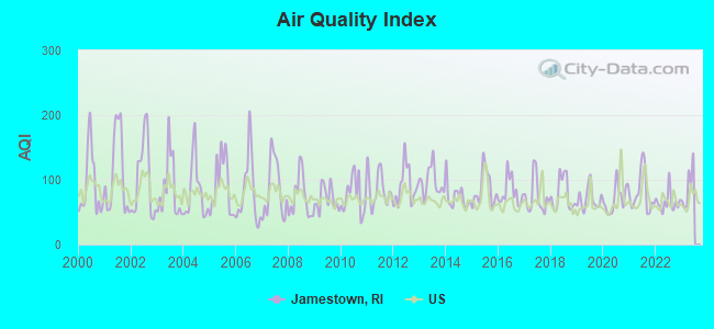
Air Quality Index (AQI) level in 2022 was 65.2. This is about average.
| City: | 65.2 |
| U.S.: | 72.6 |
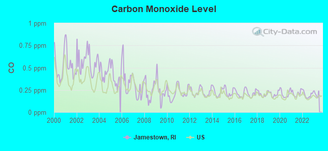
Carbon Monoxide (CO) [ppm] level in 2022 was 0.196. This is better than average. Closest monitor was 20.9 miles away from the city center.
| City: | 0.196 |
| U.S.: | 0.251 |
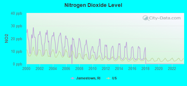
Nitrogen Dioxide (NO2) [ppb] level in 2017 was 7.11. This is worse than average. Closest monitor was 3.7 miles away from the city center.
| City: | 7.11 |
| U.S.: | 5.11 |
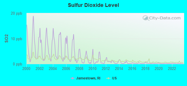
Sulfur Dioxide (SO2) [ppb] level in 2022 was 0.179. This is significantly better than average. Closest monitor was 3.7 miles away from the city center.
| City: | 0.179 |
| U.S.: | 1.515 |
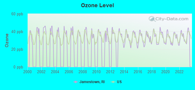
Ozone [ppb] level in 2022 was 33.2. This is about average. Closest monitor was 3.2 miles away from the city center.
| City: | 33.2 |
| U.S.: | 33.3 |
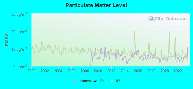
Particulate Matter (PM2.5) [µg/m3] level in 2022 was 3.87. This is significantly better than average. Closest monitor was 3.2 miles away from the city center.
| City: | 3.87 |
| U.S.: | 8.11 |
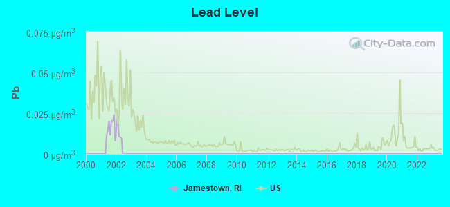
Lead (Pb) [µg/m3] level in 2001 was 0.0161. This is significantly worse than average. Closest monitor was 16.8 miles away from the city center.
| City: | 0.0161 |
| U.S.: | 0.0093 |
Tornado activity:
Jamestown-area historical tornado activity is slightly below Rhode Island state average. It is 64% smaller than the overall U.S. average.
On 6/9/1953, a category F3 (max. wind speeds 158-206 mph) tornado 37.7 miles away from the Jamestown town center injured 17 people and caused between $500,000 and $5,000,000 in damages.
On 6/9/1953, a category F4 (max. wind speeds 207-260 mph) tornado 54.5 miles away from the town center killed 90 people and injured 1228 people and caused between $50,000,000 and $500,000,000 in damages.
Earthquake activity:
Jamestown-area historical earthquake activity is significantly above Rhode Island state average. It is 74% smaller than the overall U.S. average.On 10/7/1983 at 10:18:46, a magnitude 5.3 (5.1 MB, 5.3 LG, 5.1 ML, Class: Moderate, Intensity: VI - VII) earthquake occurred 226.0 miles away from the city center
On 4/20/2002 at 10:50:47, a magnitude 5.3 (5.3 ML, Depth: 3.0 mi) earthquake occurred 238.0 miles away from Jamestown center
On 1/19/1982 at 00:14:42, a magnitude 4.7 (4.5 MB, 4.7 MD, 4.5 LG, Class: Light, Intensity: IV - V) earthquake occurred 137.4 miles away from the city center
On 4/20/2002 at 10:50:47, a magnitude 5.2 (5.2 MB, 4.2 MS, 5.2 MW, 5.0 MW) earthquake occurred 237.0 miles away from the city center
On 10/16/2012 at 23:12:25, a magnitude 4.7 (4.7 ML, Depth: 10.0 mi) earthquake occurred 148.2 miles away from Jamestown center
On 8/22/1992 at 12:20:32, a magnitude 4.8 (4.8 MB, 3.8 MS, 4.7 LG, Depth: 6.2 mi) earthquake occurred 176.0 miles away from the city center
Magnitude types: regional Lg-wave magnitude (LG), body-wave magnitude (MB), duration magnitude (MD), local magnitude (ML), surface-wave magnitude (MS), moment magnitude (MW)
Natural disasters:
The number of natural disasters in Newport County (16) is near the US average (15).Major Disasters (Presidential) Declared: 9
Emergencies Declared: 7
Causes of natural disasters: Hurricanes: 6, Blizzards: 3, Floods: 3, Snowstorms: 3, Storms: 3, Winter Storms: 2, Snow: 1, Snowfall: 1, Tropical Storm: 1, Wind: 1 (Note: some incidents may be assigned to more than one category).
Hospitals and medical centers in Jamestown:
Other hospitals and medical centers near Jamestown:
- CARRIAGE HOUSE NURSING HOME (Nursing Home, about 4 miles away; NEWPORT, RI)
- ST CLARE HOME (Nursing Home, about 5 miles away; NEWPORT, RI)
- VILLAGE HOUSE CONVALESCENT HOME INC (Nursing Home, about 5 miles away; NEWPORT, RI)
- FOREST FARM HEALTH CARE CENTER (Nursing Home, about 5 miles away; MIDDLETOWN, RI)
- HEATHERWOOD NURSING AND SUBACUTE CENTER (Nursing Home, about 5 miles away; NEWPORT, RI)
- JOHN CLARKE RETIREMENT CTR, THE (Nursing Home, about 5 miles away; MIDDLETOWN, RI)
- GRAND ISLANDER CENTER (Nursing Home, about 5 miles away; MIDDLETOWN, RI)
Colleges/universities with over 2000 students nearest to Jamestown:
- Salve Regina University (about 5 miles; Newport, RI; Full-time enrollment: 2,349)
- University of Rhode Island (about 9 miles; Kingston, RI; FT enrollment: 14,656)
- Roger Williams University (about 11 miles; Bristol, RI; FT enrollment: 4,375)
- New England Institute of Technology (about 12 miles; East Greenwich, RI; FT enrollment: 3,183)
- Community College of Rhode Island (about 15 miles; Warwick, RI; FT enrollment: 10,500)
- Bristol Community College (about 20 miles; Fall River, MA; FT enrollment: 5,707)
- University of Massachusetts-Dartmouth (about 21 miles; North Dartmouth, MA; FT enrollment: 7,545)
Public elementary/middle schools in Jamestown:
- JAMESTOWN SCHOOL-MELROSE (Students: 282, Location: 76 MELROSE AVENUE, Grades: PK-4)
- JAMESTOWN SCHOOL-LAWN (Students: 207, Location: 55 LAWN AVENUE, Grades: 5-8)
Library in Jamestown:
Points of interest:
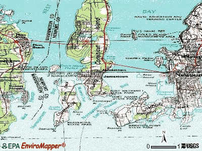
Notable locations in Jamestown: Jamestown Wastewater Treatment Facility (A), Beavertail Light (B), Jamestown Golf Course (C), Jamestown Fire Department Memorial Museum (D), Jamestown Fire Department (E), Jamestown Library (F), Jamestown Museum (G), Jamestown Philomenian Library (H), Jamestown Town Hall (I), Sydney L Wright Memorial Museum of Indian Artifacts (J), Jamestown Emergency Medical Services (K), Jamestown Police Department (L). Display/hide their locations on the map
Churches in Jamestown include: Friends Meetinghouse (A), Saint Mark Church (B), Mount Zion African Methodist Episcopal Church (C), Saint Matthews Episcopal Church (D), Central Baptist Church (E). Display/hide their locations on the map
Cemeteries: Cedar Cemetery (1), Jamestown Town Cemetery (2), Old Friends Burial Ground (3). Display/hide their locations on the map
Lakes, reservoirs, and swamps: Fox Hill Pond (A), Jamestown Reservoir (B), Round Swamp (C). Display/hide their locations on the map
Streams, rivers, and creeks: Jamestown Brook (A), Great Creek (B). Display/hide their locations on the map
Parks in Jamestown include: Windmill Hill Historic District (1), Marsh Meadows Wildlife Preserve (2), Artillery Park (3), Daughters of the American Revolution Memorial (4). Display/hide their locations on the map
Beach: Mackeral Cove Beach (A). Display/hide its location on the map
Tourist attractions: Jamestown Historical Society (Museums; Nargnstt Avenue) (1), Watson Farm (Museums; 455 North Main Rd) (2), Jamestown & Newport Ferry (Tours & Charters; 1 East Ferry Wharf) (3). Display/hide their approximate locations on the map
Hotel: The Bay Voyage (150 Conanicus Avenue) (1). Display/hide its approximate location on the map
Birthplace of: Russell E. Train - Soilder.
Drinking water stations with addresses in Jamestown and their reported violations in the past:
JAMESTOWN WATER DEPARTMENT (Population served: 3,178, Surface water):Past health violations:Past monitoring violations:
- MCL, Monthly (TCR) - In JUL-2006, Contaminant: Coliform. Follow-up actions: St Public Notif requested (AUG-04-2006), St Formal NOV issued (AUG-04-2006), St Violation/Reminder Notice (AUG-04-2006), St Compliance achieved (AUG-22-2006), St Public Notif received (AUG-22-2006)
- Monitoring and Reporting (DBP) - Between OCT-2013 and DEC-2013, Contaminant: TTHM. Follow-up actions: St Violation/Reminder Notice (FEB-13-2014), St Public Notif requested (FEB-13-2014), St Formal NOV issued (FEB-13-2014)
| This town: | 2.3 people |
| Rhode Island: | 2.4 people |
| This town: | 66.6% |
| Whole state: | 62.8% |
| This town: | 4.7% |
| Whole state: | 7.6% |
Likely homosexual households (counted as self-reported same-sex unmarried-partner households)
- Lesbian couples: 0.6% of all households
- Gay men: 0.3% of all households
| This town: | 2.9% |
| Whole state: | 11.9% |
| This town: | 1.1% |
| Whole state: | 5.4% |
10 people in homes for the mentally retarded in 2000
Banks with branches in Jamestown (2011 data):
- BankNewport: Jamestown Branch at 25 Conanicus Avenue, branch established on 1975/06/02. Info updated 2006/11/03: Bank assets: $1,098.1 mil, Deposits: $885.1 mil, headquarters in Newport, RI, positive income, Mortgage Lending Specialization, 13 total offices, Holding Company: Oceanpoint Financial Partners, Mhc
For population 15 years and over in Jamestown:
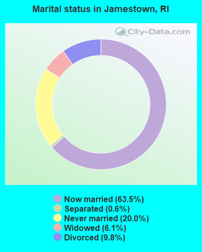
- Never married: 20.0%
- Now married: 63.5%
- Separated: 0.6%
- Widowed: 6.1%
- Divorced: 9.8%
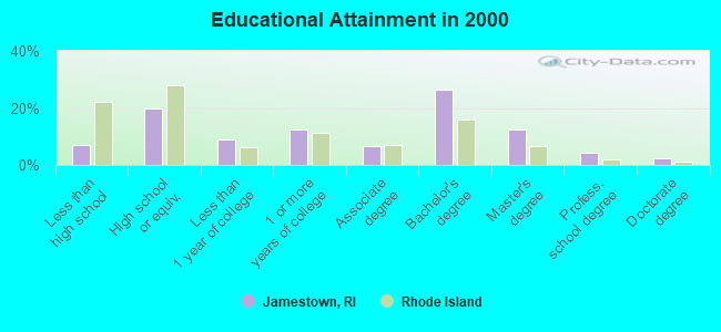
For population 25 years and over in Jamestown:
- High school or higher: 93.2%
- Bachelor's degree or higher: 45.7%
- Graduate or professional degree: 19.3%
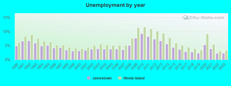
- Unemployed: 3.5%
- Mean travel time to work (commute): 34.2 minutes
| Here: | 11.5 |
| Rhode Island average: | 14.0 |
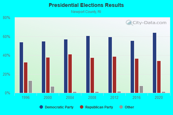
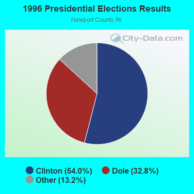
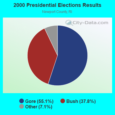
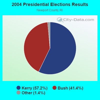
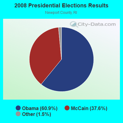
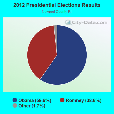
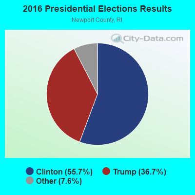
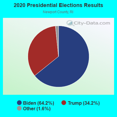
Graphs represent county-level data. Detailed 2008 Election Results
Religion statistics for Jamestown, RI (based on Newport County data)
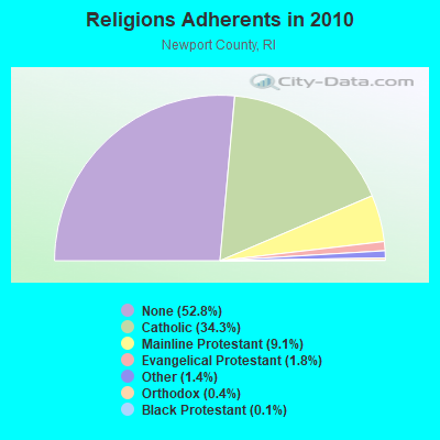
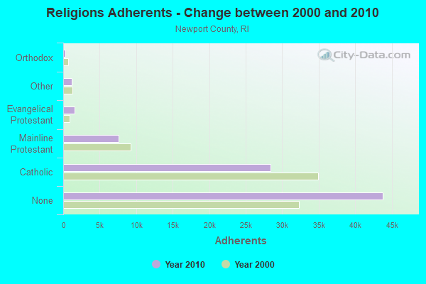
| Religion | Adherents | Congregations |
|---|---|---|
| Catholic | 28,392 | 14 |
| Mainline Protestant | 7,579 | 24 |
| Evangelical Protestant | 1,522 | 15 |
| Other | 1,174 | 9 |
| Orthodox | 300 | 1 |
| Black Protestant | 117 | 1 |
| None | 43,804 | - |
Food Environment Statistics:
| Newport County: | 1.48 / 10,000 pop. |
| Rhode Island: | 1.92 / 10,000 pop. |
| This county: | 0.12 / 10,000 pop. |
| State: | 0.05 / 10,000 pop. |
| Newport County: | 2.22 / 10,000 pop. |
| Rhode Island: | 1.42 / 10,000 pop. |
| Newport County: | 1.97 / 10,000 pop. |
| State: | 2.24 / 10,000 pop. |
| Here: | 17.26 / 10,000 pop. |
| State: | 9.75 / 10,000 pop. |
| This county: | 7.2% |
| Rhode Island: | 7.9% |
| Newport County: | 18.4% |
| Rhode Island: | 22.6% |
| This county: | 15.9% |
| State: | 16.3% |
8.14% of this county's 2021 resident taxpayers lived in other counties in 2020 ($131,002 average adjusted gross income)
| Here: | 8.14% |
| Rhode Island average: | 5.99% |
0.15% of residents moved from foreign countries ($1,480 average AGI)
Newport County: 0.15% Rhode Island average: 0.03%
Top counties from which taxpayers relocated into this county between 2020 and 2021:
| from Providence County, RI | |
| from Bristol County, MA | |
| from Bristol County, RI |
8.40% of this county's 2020 resident taxpayers moved to other counties in 2021 ($96,134 average adjusted gross income)
| Here: | 8.40% |
| Rhode Island average: | 5.97% |
0.10% of residents moved to foreign countries ($1,383 average AGI)
Newport County: 0.10% Rhode Island average: 0.02%
Top counties to which taxpayers relocated from this county between 2020 and 2021:
| to Providence County, RI | |
| to Bristol County, MA | |
| to Kent County, RI |
Businesses in Jamestown, RI
- FedEx: 2
- True Value: 1
Strongest AM radio stations in Jamestown:
- WADK (1540 AM; 1 kW; NEWPORT, RI; Owner: ASTRO TELE-COMMUNICATIONS CORP.)
- WALE (990 AM; 50 kW; GREENVILLE, RI; Owner: NORTH AMERICAN BROADCASTING CO., INC.)
- WPRO (630 AM; 5 kW; PROVIDENCE, RI; Owner: CITADEL BROADCASTING COMPANY)
- WEEI (850 AM; 50 kW; BOSTON, MA; Owner: ENTERCOM BOSTON LICENSE, LLC)
- WCRN (830 AM; 50 kW; WORCESTER, MA; Owner: CARTER BROADCASTING CORPORATION)
- WHJJ (920 AM; 5 kW; PROVIDENCE, RI)
- WRKO (680 AM; 50 kW; BOSTON, MA; Owner: ENTERCOM BOSTON LICENSE, LLC)
- WKOX (1200 AM; 50 kW; FRAMINGHAM, MA; Owner: CAPSTAR TX LIMITED PARTNERSHIP)
- WRNI (1290 AM; 10 kW; PROVIDENCE, RI; Owner: WRNI FOUNDATION)
- WBZ (1030 AM; 50 kW; BOSTON, MA; Owner: INFINITY BROADCASTING OPERATIONS, INC.)
- WARV (1590 AM; 5 kW; WARWICK, RI; Owner: BLOUNT COMMUNICATIONS, INC.)
- WBIX (1060 AM; 40 kW; NATICK, MA; Owner: LANGER BROADCASTING CORPORATION)
- WSKO (790 AM; 5 kW; PROVIDENCE, RI; Owner: CITADEL BROADCASTING COMPANY)
Strongest FM radio stations in Jamestown:
- WKKB (100.3 FM; MIDDLETOWN, RI; Owner: CITADEL BROADCASTING COMPANY)
- W243AI (96.5 FM; NEWPORT, RI; Owner: DAVID P. MAXSON)
- WRIU (90.3 FM; KINGSTON, RI; Owner: UNIVERSITY OF RHODE ISLAND)
- WSKO-FM (99.7 FM; WAKEFIELD-PEACEDALE, RI; Owner: CITADEL BROADCASTING COMPANY)
- WWBB (101.5 FM; PROVIDENCE, RI; Owner: CLEAR CHANNEL BROADCASTING LICENSES, INC.)
- WAKX (102.7 FM; NARRAGANSETT PIER, RI; Owner: AAA ENTERTAINMENT LICENSING LLC)
- WPRO-FM (92.3 FM; PROVIDENCE, RI; Owner: CITADEL BROADCASTING COMPANY)
- WWRX-FM (103.7 FM; WESTERLY, RI; Owner: FNX BROADCASTING OF RHODE ISLAND, LLC)
- WWLI (105.1 FM; PROVIDENCE, RI; Owner: CITADEL BROADCASTING COMPANY)
- WSNE-FM (93.3 FM; TAUNTON, MA; Owner: CAPSTAR TX LIMITED PARTNERSHIP)
- WBRU (95.5 FM; PROVIDENCE, RI; Owner: BROWN BROADCASTING SERVICE, INC.)
- WHJY (94.1 FM; PROVIDENCE, RI; Owner: CAPSTAR TX LIMITED PARTNERSHIP)
- WCTK (98.1 FM; NEW BEDFORD, MA; Owner: HALL COMMUNICATIONS, INC.)
- WJFD-FM (97.3 FM; NEW BEDFORD, MA; Owner: EDMUND DINIS, TRUSTEE)
- WHJM (107.7 FM; PAWCATUCK, CT; Owner: FULLER BROADCASTING INTERNATIONAL, LLC)
- WSMU-FM (91.1 FM; NORTH DARTMOUTH, MA; Owner: UNIVERSITY OF MASSACHUSETTS)
- WWKX (106.3 FM; WOONSOCKET, RI; Owner: AAA ENTERTAINMENT LICENSING LLC)
- WXHQ-LP (105.9 FM; NEWPORT, RI; Owner: NEWPORT MUSICAL ARTS ASSOCIATION)
- WFHN (107.1 FM; FAIRHAVEN, MA; Owner: CITADEL BROADCASTING COMPANY)
- WXLM (102.3 FM; STONINGTON, CT; Owner: CITADEL BROADCASTING COMPANY)
TV broadcast stations around Jamestown:
- WPXQ (Channel 69; BLOCK ISLAND, RI; Owner: OCEAN STATE TELEVISION, L.L.C.)
- WNAC-TV (Channel 64; PROVIDENCE, RI; Owner: WNAC, LLC)
- WLNE-TV (Channel 6; NEW BEDFORD, MA; Owner: FREEDOM BROADCASTING OF SOUTHERN NEW ENGLAND, INC.)
- WPRI-TV (Channel 12; PROVIDENCE, RI; Owner: TVL BROADCASTING OF RHODE ISLAND, LLC)
- WJAR (Channel 10; PROVIDENCE, RI; Owner: OUTLET BROADCASTING, INC.)
- WSBE-TV (Channel 36; PROVIDENCE, RI; Owner: RHODE ISLAND PUBLIC TELECOM. AUTHORITY)
- WLWC (Channel 28; NEW BEDFORD, MA; Owner: C-28 FCC LICENSEE SUBSIDIARY, LLC)
- WHPX (Channel 26; NEW LONDON, CT; Owner: PAXSON HARTFORD LICENSE, INC.)
- WWDP (Channel 46; NORWELL, MA; Owner: NORWELL TELEVISION, LLC)
- WRIW-LP (Channel 50; PROVIDENCE, RI; Owner: ZGS PROVIDENCE, INC.)
- National Bridge Inventory (NBI) Statistics
- 12Number of bridges
- 1,906ft / 581mTotal length
- $363,123,000Total costs
- 235,700Total average daily traffic
- 15,768Total average daily truck traffic
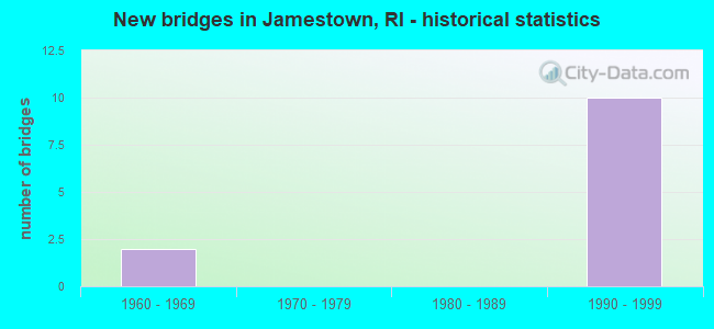
- New bridges - historical statistics
- 21960-1969
- 101990-1999
FCC Registered Cell Phone Towers:
1- High Street And Howland Avenue (2364) (Lat: 41.491056 Lon: -71.373194), Type: Tank, Structure height: 31.4 m, Overall height: 33.2 m, Call Sign: KNKN849
Assigned Frequencies: 869.040 MHz, 869.040 MHz, 869.040 MHz, 824.040 MHz, 824.040 MHz, 824.040 MHz, 890.010 MHz, 890.010 MHz, 890.010 MHz, 845.010 MHz, 845.010 MHz, 845.010 MHzGrant Date: 09/21/2021, Expiration Date: 10/01/2031, Certifier: David C JatlowRegistrant: At&t Services, Inc., 208 S Akard St, 20f, Dallas, TX 75202, Phone: (855) 699-7073, Email:
FCC Registered Private Land Mobile Towers:
2- Newport Pell Bridge Toll Plaza (Lat: 41.510861 Lon: -71.366361), Type: Building, Structure height: 5.1 m, Overall height: 6.5 m, Call Sign: WQJN561,
Assigned Frequencies: 915.750 MHz, Grant Date: 11/07/2008, Expiration Date: 05/06/2009, Cancellation Date: 06/27/2009, Certifier: Earl J Croft, Registrant: Telvent Caseta, 211 E. 7th Street, Suite #800, Austin, TX 78701, Phone: (512) 968-2068, Fax: (512) 592-5934, Email:
- Newport Pell Bridge Toll Plaza (Lat: 41.510861 Lon: -71.366361), Type: Building, Structure height: 5.1 m, Overall height: 6.5 m, Call Sign: WQJZ414,
Assigned Frequencies: 915.750 MHz, Grant Date: 02/04/2019, Expiration Date: 02/23/2029, Certifier: Earl J Croft, Registrant: Holland & Knight LLP, 2099 Pennsylvania Ave., N.W., Suite #100, Washington, DC 20006-6801, Phone: (202) 955-3000, Fax: (202) 955-5564, Email:
FCC Registered Broadcast Land Mobile Towers:
1- Fire Headquarters Narragansett Ave (Lat: 41.496500 Lon: -71.370889), Type: Bant, Structure height: 15 m, Overall height: 18 m, Call Sign: KCE673,
Assigned Frequencies: 153.950 MHz, 154.280 MHz, Grant Date: 05/21/2013, Expiration Date: 08/17/2023, Cancellation Date: 10/21/2023, Registrant: Universal Licensing Service, 4401-A Connecticut Ave Nw #232, Washington, DC 20008, Phone: (877) 677-3639, Fax: (949) 209-3097, Email:
FCC Registered Microwave Towers:
2- Claiborne Pell/Newpo, Rt 138 (Lat: 41.504306 Lon: -71.345833), Type: Bridg, Structure height: 121.9 m, Call Sign: WRHT915,
Assigned Frequencies: 21935.0 MHz, 21935.0 MHz, 21935.0 MHz, 21935.0 MHz, 21935.0 MHz, 21935.0 MHz, 21935.0 MHz, Grant Date: 06/17/2020, Expiration Date: 06/17/2030, Certifier: Thomas Guthlein, Registrant: Micronet Communications, Inc., 812 Lexington Dr, Plano, TX 75075, Phone: (972) 422-7200, Email:
- TS-0000028623, 16 Green Ln (Lat: 41.495417 Lon: -71.369417), Type: Building, Structure height: 4 m, Call Sign: WRJJ544,
Assigned Frequencies: 22125.0 MHz, 22125.0 MHz, 22125.0 MHz, Grant Date: 09/10/2020, Expiration Date: 09/10/2030, Certifier: Michael Connors, Registrant: Micronet Communications, Inc., 812 Lexington Dr, Plano, TX 75075, Phone: (972) 422-7200, Email:
FCC Registered Maritime Coast & Aviation Ground Towers:
1- 43 Conanicus Ave (Lat: 41.362611 Lon: -71.366722), Overall height: 11 m, Call Sign: WHX596, Licensee ID: L00095510,
Assigned Frequencies: 156.450 MHz, 156.600 MHz, 156.800 MHz, 156.850 MHz, Grant Date: 08/03/2002, Expiration Date: 08/04/2012, Cancellation Date: 10/06/2012, Registrant: Jamestown, Town Of, Jamestown, RI 02835
FCC Registered Amateur Radio Licenses:
62 (See the full list of FCC Registered Amateur Radio Licenses in Jamestown)FAA Registered Aircraft:
8 (See the full list of FAA Registered Aircraft in Jamestown)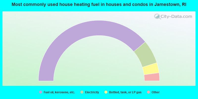
- 77.7%Fuel oil, kerosene, etc.
- 12.6%Electricity
- 5.4%Bottled, tank, or LP gas
- 3.0%Wood
- 1.3%Solar energy
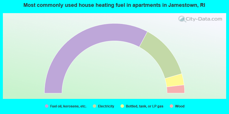
- 65.6%Fuel oil, kerosene, etc.
- 25.4%Electricity
- 5.2%Bottled, tank, or LP gas
- 3.8%Wood
Jamestown compared to Rhode Island state average:
- Median house value above state average.
- Unemployed percentage significantly below state average.
- Black race population percentage significantly below state average.
- Hispanic race population percentage significantly below state average.
- Median age significantly above state average.
- Foreign-born population percentage significantly below state average.
- Renting percentage below state average.
- Length of stay since moving in significantly above state average.
- Number of rooms per house significantly below state average.
- House age significantly below state average.
- Percentage of population with a bachelor's degree or higher above state average.
Jamestown on our top lists:
- #1 on the list of "Top 101 cities with largest percentage of females in occupations: architects, surveyors, and cartographers (population 5,000+)"
- #6 on the list of "Top 101 cities with largest percentage of females in occupations: other management occupations except farmers and farm managers (population 5,000+)"
- #9 on the list of "Top 101 cities with largest percentage of males in occupations: special education teachers (population 5,000+)"
- #10 on the list of "Top 101 cities with largest percentage of females in occupations: transportation, tourism, and lodging attendants (population 5,000+)"
- #12 on the list of "Top 101 cities with largest percentage of males in occupations: art and design workers (population 5,000+)"
- #27 on the list of "Top 101 cities with largest percentage of females in industries: air transportation (population 5,000+)"
- #28 on the list of "Top 101 cities with largest percentage of males in occupations: other food preparation and serving workers including supervisors (population 5,000+)"
- #38 on the list of "Top 101 cities with largest percentage of males in industries: private households (population 5,000+)"
- #42 on the list of "Top 101 cities with largest percentage of males in industries: retail florists (population 5,000+)"
- #45 on the list of "Top 101 cities with largest percentage of males in industries: used merchandise, gift, novelty, and souvenir, and other miscellaneous stores (population 5,000+)"
- #50 on the list of "Top 101 cities with largest percentage of females in industries: used merchandise, gift, novelty, and souvenir, and other miscellaneous stores (population 5,000+)"
- #54 on the list of "Top 101 cities with the lowest number of robberies per 100,000 residents (population 5,000+)"
- #54 on the list of "Top 101 cities with largest percentage of males in industries: other direct selling establishments (population 5,000+)"
- #73 on the list of "Top 101 cities with largest percentage of males in industries: water transportation (population 5,000+)"
- #77 on the list of "Top 101 cities with largest percentage of males in industries: warehousing and storage (population 5,000+)"
- #89 on the list of "Top 101 cities with largest percentage of females in industries: music stores (population 5,000+)"
- #98 on the list of "Top 101 cities with largest percentage of females in industries: jewelry, luggage, and leather goods stores (population 5,000+)"
- #16 on the list of "Top 101 counties with the highest percentage of residents that visited a dentist within the past year"
- #20 on the list of "Top 101 counties with the highest percentage of residents that smoked 100+ cigarettes in their lives"
- #21 on the list of "Top 101 counties with the lowest ground withdrawal of fresh water for public supply (pop. 50,000+)"
- #33 on the list of "Top 101 counties with the best general health status score of residents (1-5), 3 years of data"
- #35 on the list of "Top 101 counties with the lowest percentage of residents that keep firearms around their homes"

|
|
Total of 66 patent applications in 2008-2024.