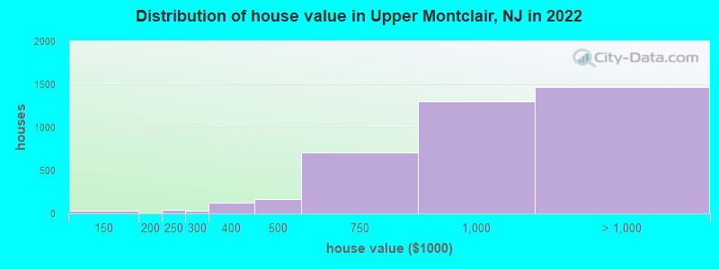
Estimated median house or condo value in 2022: $494,100
Upper Montclair:
$494,100
NJ:
$428,900
Mean prices in 2022:all housing units: over $1,000,000; detached houses: over $1,000,000; townhouses or other attached units: $900,335; in 2-unit structures: $778,857; in 5-or-more-unit structures: $433,975
Median gross rent in 2022: $2,256.
March 2022 cost of living index in Upper Montclair: 115.2 (more than average, U.S. average is 100)Percentage of residents living in poverty in 2022: 2.2%
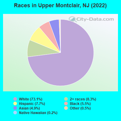
(1.9% for White Non-Hispanic residents, 6.8% for Black residents, 3.0% for Hispanic or Latino residents, 26.2% for American Indian residents, 4.4% for other race residents, 0.2% for two or more races residents)
Ancestries: Irish (9.1%), European (7.0%), Italian (6.9%), German (5.9%), English (4.8%), American (4.1%).
Current Local Time: EST time zone
Elevation: 347 feet
1,495 residents are foreign born (4.3% Asia, 3.6% Europe, 2.9% Latin America).
This place:
12.1%
New Jersey:
23.2%
Median real estate property taxes paid for housing units with mortgages in 2022: $10,001 (1.0%) Median real estate property taxes paid for housing units with no mortgage in 2022: $10,001 (1.1%)
Nearest city with pop. 50,000+: Clifton, NJ (2.9 miles , pop. 78,672).
Nearest city with pop. 200,000+: Newark, NJ (7.7 miles , pop. 273,546).
Nearest city with pop. 1,000,000+: Manhattan, NY (13.1 miles , pop. 1,537,195).
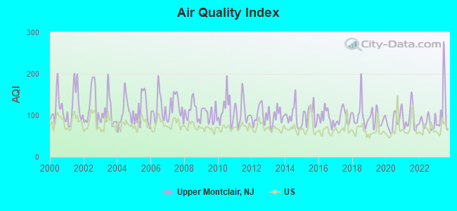
Air Quality Index (AQI) level in 2023 was 113. This is significantly worse than average.
City:
113
U.S.:
73
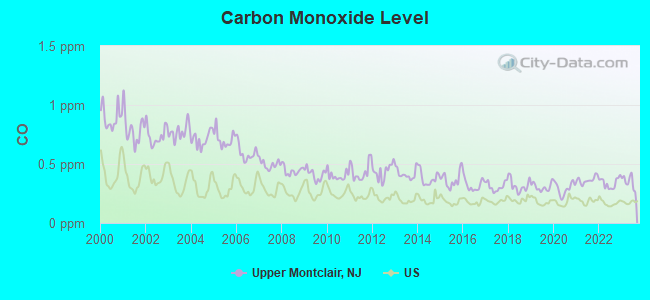
Carbon Monoxide (CO) [ppm] level in 2023 was 0.350. This is worse than average.Closest monitor was 6.1 miles away from the city center.
City:
0.350
U.S.:
0.251
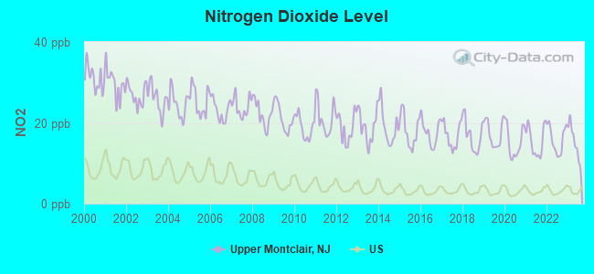
Nitrogen Dioxide (NO2) [ppb] level in 2023 was 15.3. This is significantly worse than average.Closest monitor was 4.6 miles away from the city center.
City:
15.3
U.S.:
5.1
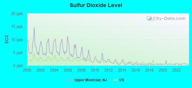
Sulfur Dioxide (SO2) [ppb] level in 2023 was 0.499. This is significantly better than average.Closest monitor was 4.6 miles away from the city center.
City:
0.499
U.S.:
1.515
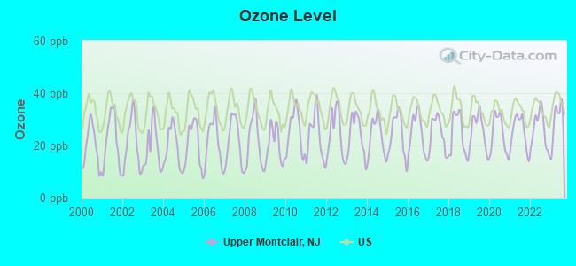
Ozone [ppb] level in 2023 was 29.5. This is about average.Closest monitor was 6.1 miles away from the city center.
City:
29.5
U.S.:
33.3
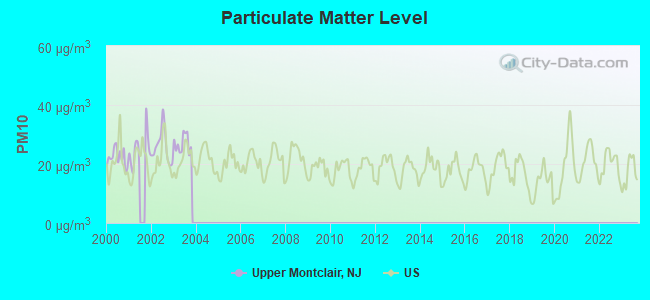
Particulate Matter (PM10) [µg/m3] level in 2003 was 26.9. This is worse than average.Closest monitor was 8.7 miles away from the city center.
City:
26.9
U.S.:
19.2
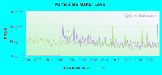
Particulate Matter (PM2.5) [µg/m3] level in 2023 was 9.09. This is about average.Closest monitor was 5.3 miles away from the city center.
City:
9.09
U.S.:
8.11
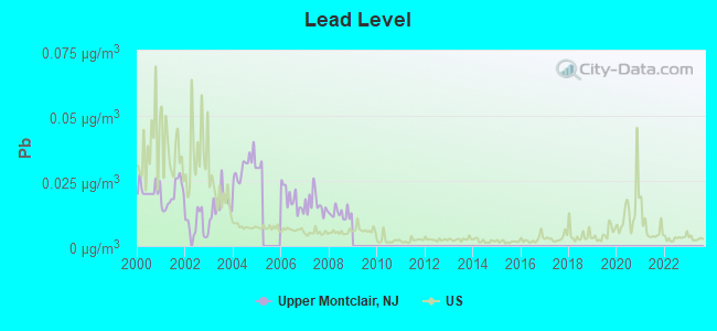
Lead (Pb) [µg/m3] level in 2008 was 0.0125. This is worse than average.Closest monitor was 4.6 miles away from the city center.
City:
0.0125
U.S.:
0.0093
Tornado activity:
Upper Montclair-area historical tornado activity is near New Jersey state average. It is 35% smaller than the overall U.S. average.
On 5/28/1973, a category F3 (max. wind speeds 158-206 mph) tornado 15.9 miles away from the Upper Montclair place center causedbetween $50,000 and $500,000 in damages.
On 5/28/1973, a category F3 tornado 27.1 miles away from the place center injured 12 peopleand causedbetween $50,000 and $500,000 in damages.
Earthquake activity:
Upper Montclair-area historical earthquake activity is significantly above New Jersey state average. It is 68% smaller than the overall U.S. average.
On 8/23/2011 at 17:51:04, a magnitude 5.8 (5.8 MW, Depth: 3.7 mi, Class: Moderate, Intensity: VI - VII) earthquake occurred 284.8 miles away from Upper Montclair center On 10/7/1983 at 10:18:46, a magnitude 5.3 (5.1 MB, 5.3 LG, 5.1 ML) earthquake occurred 215.0 miles away from the city center On 1/16/1994 at 01:49:16, a magnitude 4.6 (4.6 MB, 4.6 LG, Depth: 3.1 mi, Class: Light, Intensity: IV - V) earthquake occurred 102.8 miles away from the city center On 4/20/2002 at 10:50:47, a magnitude 5.3 (5.3 ML, Depth: 3.0 mi) earthquake occurred 254.9 miles away from the city center On 4/20/2002 at 10:50:47, a magnitude 5.2 (5.2 MB, 4.2 MS, 5.2 MW, 5.0 MW) earthquake occurred 253.0 miles away from Upper Montclair center On 1/16/1994 at 00:42:43, a magnitude 4.2 (4.2 MB, 4.0 LG, Depth: 3.1 mi) earthquake occurred 101.4 miles away from the city center Magnitude types: regional Lg-wave magnitude (LG), body-wave magnitude (MB), local magnitude (ML), surface-wave magnitude (MS), moment magnitude (MW)
Natural disasters:
The number of natural disasters in Essex County (30) is a lot greater than the US average (15). Major Disasters (Presidential) Declared: 19 Emergencies Declared: 10
Causes of natural disasters: Floods: 8, Hurricanes: 7, Storms: 7, Heavy Rains: 4, Snowstorms: 4, Winter Storms: 3, Blizzards: 2, Water Shortages: 2, Power Outage: 1, Tornado: 1, Tropical Storm: 1, Wind: 1, Other: 3 (Note: some incidents may be assigned to more than one category).
Main business address for: APPLIED SPECTRUM TECHNOLOGIES INC (TELEPHONE & TELEGRAPH APPARATUS).
Hospitals and medical centers near Upper Montclair:
HOSPICE OF NEW JERSEY (Hospital, about 2 miles away; BLOOMFIELD, NJ)
WATERVIEW CENTER (Nursing Home, about 2 miles away; CEDAR GROVE, NJ)
WATERVIEW NH (Nursing Home, about 2 miles away; CEDAR GROVE, NJ)
CANTERBURY AT CEDAR GROVE (Nursing Home, about 2 miles away; CEDAR GROVE, NJ)
CEDAR HILL HEALTH CARE CENTER (Nursing Home, about 2 miles away; CEDAR GROVE, NJ)
KESSLER CARE CTR AT CEDAR GROVE (Nursing Home, about 2 miles away; CEDAR GROVE, NJ)
KEW GARDENS DIALYSIS CENTER (Dialysis Facility, about 2 miles away; KEW GARDENS, NY)
Amtrak stations near Upper Montclair:
8 miles: NEWARK (RAYMOND PLAZA WEST) . Services: ticket office, fully wheelchair accessible, enclosed waiting area, public restrooms, public payphones, snack bar, ATM, paid short-term parking, paid long-term parking, call for car rental service, taxi stand, intercity bus service, public transit connection.
11 miles: NEWARK INTERNATIONAL AIRPORT (NEWARK, ) . Services: ticket office, enclosed waiting area, public restrooms, public payphones.
13 miles: NEW YORK (PENN STA) (NEW YORK, 7TH AVE. & W. 32ND ST.) . Services: ticket office, fully wheelchair accessible, enclosed waiting area, public restrooms, public payphones, full-service food facilities, snack bar, vending machines, ATM, paid short-term parking, paid long-term parking, call for car rental service, taxi stand, public transit connection.
Colleges/universities with over 2000 students nearest to Upper Montclair:
Montclair State University (about 1 miles; Montclair, NJ; Full-time enrollment: 16,277)
Berkeley College-Woodland Park (about 4 miles; Woodland Park, NJ; FT enrollment: 2,938)
Passaic County Community College (about 6 miles; Paterson, NJ; FT enrollment: 6,351)
William Paterson University of New Jersey (about 7 miles; Wayne, NJ; FT enrollment: 10,198)
University of Medicine and Dentistry of New Jersey (about 8 miles; Newark, NJ; FT enrollment: 3,210)
New Jersey Institute of Technology (about 8 miles; Newark, NJ; FT enrollment: 8,212)
Rutgers University-Newark (about 8 miles; Newark, NJ; FT enrollment: 9,869)
Notable locations in Upper Montclair: Upper Montclair Station (A), Bond House (B), President's House (C), Alderice House (D), Montclair Fire Department Station 2 (E). Display/hide their locations on the map
Churches in Upper Montclair include: Saint James Episcopal Church (A), Friends Meeting House (B), Montclair Heights Reformed Church (C), Union Congregational Church (D). Display/hide their locations on the map
Parks in Upper Montclair include: Pearl Brook Park (1), Mountainside Park (2), Anderson Park (3), Alonzo F Bonsal Wildlife Preserve (4), Yantacaw Brook Park (5), Tuers Park (6). Display/hide their locations on the map
Birthplace of: Sterling Hayden - (died 1986).
Essex County has a predicted average indoor radon screening level between 2 and 4 pCi/L (pico curies per liter) - Moderate Potential
Average household size:
This place:
2.8 people
New Jersey:
2.7 people
Percentage of family households:
This place:
75.3%
Whole state:
69.3%
Percentage of households with unmarried partners:
This place:
4.5%
Whole state:
5.9%
Likely homosexual households (counted as self-reported same-sex unmarried-partner households)
Lesbian couples: 1.2% of all households
Gay men: 0.8% of all households
12 people in other noninstitutional facilities in 2010
5 people in workers' group living quarters and job corps centers in 2010
Banks with branches in Upper Montclair (2011 data):
Valley National Bank: Upper Montclair at 529 Valley Road, branch established on 2006/12/04; Upper Montclair Branch at 539 Valley Road, branch established on 2010/01/01. Info updated 2012/01/10: Bank assets: $14,186.7 mil, Deposits: $9,715.7 mil, headquarters in Wayne, NJ, positive income, Commercial Lending Specialization, 219 total offices, Holding Company: Valley National Bancorp
JPMorgan Chase Bank, National Association: Upper Montclair Branch at 600 Valley Road, branch established on 1957/12/23; Upper Montclair Drive-In at 580 Valley Road, branch established on 1997/07/01. Info updated 2011/11/10: Bank assets: $1,811,678.0 mil, Deposits: $1,190,738.0 mil, headquarters in Columbus, OH, positive income, International Specialization, 5577 total offices, Holding Company: Jpmorgan Chase & Co.
Boiling Springs Savings Bank: Watchung Avenue Branch at 122 Watchung Avenue, branch established on 2006/09/30. Info updated 2010/06/03: Bank assets: $1,356.4 mil, Deposits: $1,126.1 mil, headquarters in Rutherford, NJ, positive income, Commercial Lending Specialization, 17 total offices, Holding Company: Boiling Springs, Mhc
Capital One, National Association: Upper Montclair Branch at 605 Valley Road, branch established on 1999/05/24. Info updated 2011/07/01: Bank assets: $133,477.8 mil, Deposits: $97,063.7 mil, headquarters in Mclean, VA, positive income, 984 total offices, Holding Company: Capital One Financial Corporation
New York Community Bank: Upper Montclair Branch at 597 Valley Road, branch established on 1922/01/01. Info updated 2010/03/29: Bank assets: $39,468.7 mil, Deposits: $20,709.8 mil, headquarters in Westbury, NY, positive income, Commercial Lending Specialization, 247 total offices, Holding Company: New York Community Bancorp, Inc.
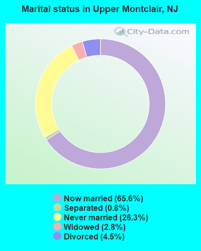
For population 15 years and over in Upper Montclair:
Never married: 26.3%
Now married: 65.6%
Separated: 0.8%
Widowed: 2.8%
Divorced: 4.5%
For population 25 years and over in Upper Montclair:
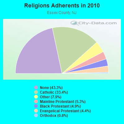
Religion statistics for Upper Montclair, NJ (based on Essex County data)
Religion
Adherents
Congregations
Catholic
261,966
65
Other
61,850
81
Mainline Protestant
41,339
171
Black Protestant
38,687
88
Evangelical Protestant
34,666
191
Orthodox
6,188
12
None
339,273
-
Source: Clifford Grammich, Kirk Hadaway, Richard Houseal, Dale E.Jones, Alexei Krindatch, Richie Stanley and Richard H.Taylor. 2012. 2010 U.S.Religion Census: Religious Congregations & Membership Study. Association of Statisticians of American Religious Bodies. Jones, Dale E., et al. 2002. Congregations and Membership in the United States 2000. Nashville, TN: Glenmary Research Center. Graphs represent county-level data
Food Environment Statistics:
Number of grocery stores: 305
This county:
3.95 / 10,000 pop.
State:
2.90 / 10,000 pop.
Number of convenience stores (no gas): 119
This county:
1.54 / 10,000 pop.
State:
1.76 / 10,000 pop.
Number of convenience stores (with gas): 30
This county:
0.39 / 10,000 pop.
New Jersey:
0.81 / 10,000 pop.
Number of full-service restaurants: 463
Here:
6.00 / 10,000 pop.
New Jersey:
7.15 / 10,000 pop.
Adult diabetes rate:
Essex County:
9.4%
New Jersey:
8.3%
Adult obesity rate:
Essex County:
25.3%
New Jersey:
23.3%
Low-income preschool obesity rate:
Essex County:
16.5%
New Jersey:
18.0%
6.52% of this county's 2021 resident taxpayers lived in other counties in 2020 ($103,528 average adjusted gross income)
Here:
6.52%
New Jersey average:
6.70%
0.01% of residents moved from foreign countries ($16 average AGI)
Essex County:
0.01%
New Jersey average:
0.01%
Top counties from which taxpayers relocated into this county between 2020 and 2021:
Aircraft: AERONCA 65-C (Category: Land, Seats: 2, Weight: Up to 12,499 Pounds, Speed: 75 mph), Engine: CONT MOTOR A&C65 SERIES (65 HP) (Reciprocating) N-Number: 22468, N22468, N-22468, Serial Number: C4189, Year manufactured: 1939 Registrant (Individual): Forrest A Lott, 52 Watching Ave, Upper Montclair, NJ 07043 Deregistered:Cancel Date: 04/03/2020
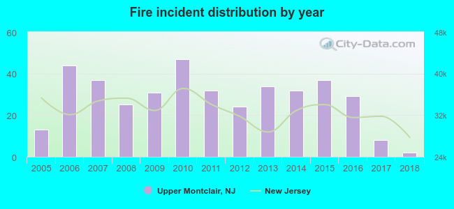
2005 - 2018 National Fire Incident Reporting System (NFIRS) incidents
According to the data from the years 2005 - 2018 the average number of fires per year is 28. The highest number of fires - 47 took place in 2010, and the least - 2 in 2018. The data has a decreasing trend.
When looking into fire subcategories, the most incidents belonged to: Structure Fires (65.8%), and Outside Fires (26.1%).
Fire incident types reported to NFIRS in Upper Montclair, NJ
#6 on the list of "Top 100 cities with oldest houses (pop. 5,000+)"
#11 on the list of "Top 101 cities with largest percentage of males in occupations: legal occupations (population 5,000+)"
#12 on the list of "Top 101 cities with largest percentage of females in occupations: arts, design, entertainment, sports, and media occupations (population 5,000+)"
#13 on the list of "Top 101 cities with largest percentage of males in occupations: arts, design, entertainment, sports, and media occupations (population 5,000+)"
#20 on the list of "Top 101 cities with largest percentage of males in industries: information (population 5,000+)"
#25 on the list of "Top 100 cities with highest ratio of median house value to median household income (pop. 5,000+)"
#29 on the list of "Top 101 cities with the largest percentage of likely lesbian couples (counted as self-reported female-female unmarried-partner households) (population 5,000+)"
#45 on the list of "Top 101 cities with the most people having Master's or Doctorate degrees (population 5,000+)"
#56 on the list of "Top 101 cities with the largest percentage of likely homosexual households (counted as self-reported same-sex unmarried-partner households) (population 5,000+)"
#58 on the list of "Top 101 cities with largest percentage of females in occupations: management occupations (population 5,000+)"
#69 on the list of "Top 100 best educated cities (highest percentage of bachelor degree holding residents)"
#73 on the list of "Top 101 cities with largest percentage of females in industries: professional, scientific, and technical services (population 5,000+)"
#76 on the list of "Top 101 cities with largest percentage of males in industries: finance and insurance (population 5,000+)"
#92 on the list of "Top 100 cities with old houses but young residents (pop. 5,000+)"
#101 on the list of "Top 101 cities with largest percentage of males in industries: professional, scientific, and technical services (population 5,000+)"
#7 on the list of "Top 101 counties with the highest Nitrogen Dioxide air pollution readings in 2012 (ppm)"
#9 on the list of "Top 101 counties with the lowest percentage of residents that keep firearms around their homes"
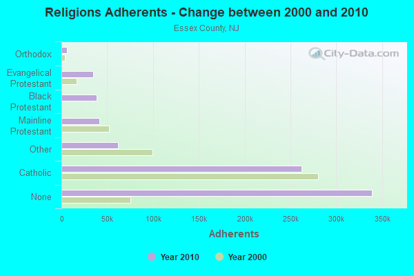
#19 on the list of "Top 101 counties with the most Black Protestant adherents"
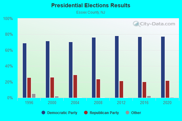
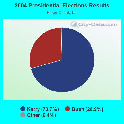
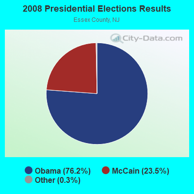
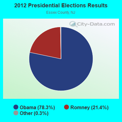
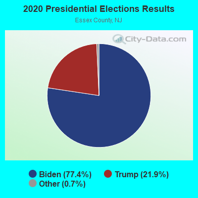
#20 on the list of "Top 101 counties with highest percentage of residents voting for Obama (Democrat) in the 2012 Presidential Election (pop. 50,000+)"
#23 on the list of "Top 101 counties with the most Black Protestant congregations (pop. 50,000+)"


 Recent articles from our blog. Our writers, many of them Ph.D. graduates or candidates, create easy-to-read articles on a wide variety of topics.
 (2.9 miles
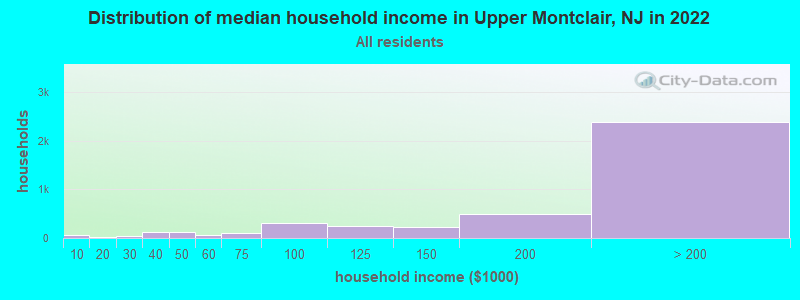

 According to the data from the years 2005 - 2018 the average number of fires per year is 28. The highest number of fires - 47 took place in 2010, and the least - 2 in 2018. The data has a decreasing trend.
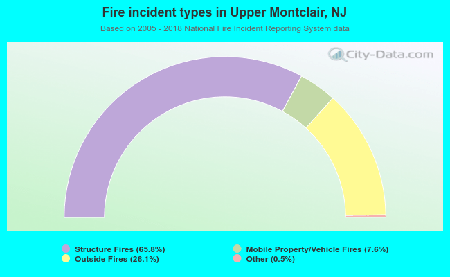 When looking into fire subcategories, the most incidents belonged to: Structure Fires (65.8%), and Outside Fires (26.1%).