Drexel Hill, Pennsylvania Neighborhood Map - Income, House Prices, Occupations, Boundaries
Settings
X

- City boundary
- Neighborhood boundaries
Business Search - 14 Million verified businesses
Neighborhoods:
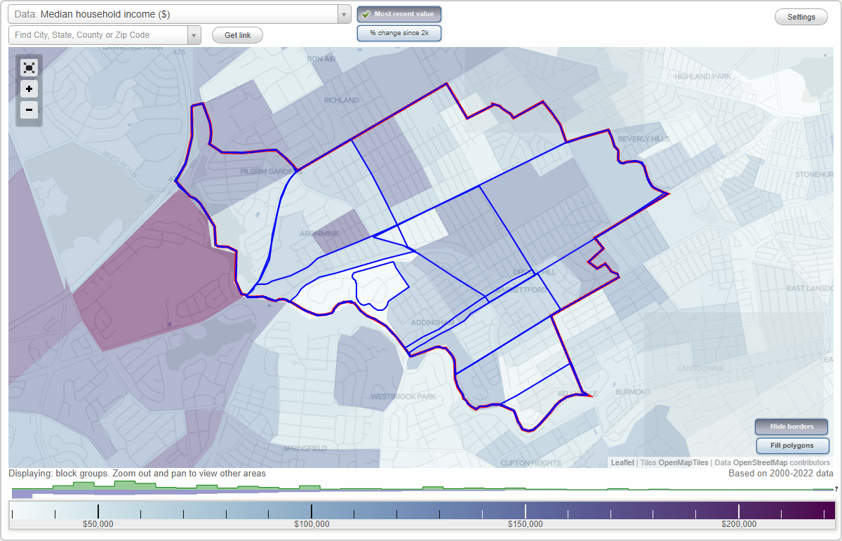
Addingham, Aronimink, Drexel Hill, Drexel Hill Center, Drexelbrook, Garrettford, Kellyville, Oakview, Pilgrim GardensAddingham neighborhood in Drexel Hill statistics: (Find on map)
Area: 0.904 square miles
Population: 7,508
Population density:
Median household income in 2021:
Median rent in in 2021:
Male vs Females
Median age
Housing prices:
Average estimated value of detached houses in 2021 (34.6% of all units):
Average estimated value of townhouses or other attached units in 2021 (34.1% of all units):
Average estimated value of housing units in 2-unit structures in 2021 (8.5% of all units):
Most popular occupations of males: management occupations (except farmers) (18.5%); sales and office occupations (18.5%); construction, extraction, and maintenance occupations (15.9%); service occupations (11.1%); business and financial operations occupations (5.3%); education, training, and library occupations (5.3%); transportation occupations (4.5%)
Most popular occupations of females: sales and office occupations (26.9%); healthcare practitioners and technical occupations (20.3%); service occupations (19.1%); education, training, and library occupations (9.5%); management occupations (except farmers) (6.1%); business and financial operations occupations (5.3%); community and social services occupations (3.9%)
Roads and streets: Woodland Ave; Ferne Blvd; Huey Ave; Burmont Rd; School Ln; Rosemont Ave; Bloomfield Ave; Berry Ave; Revere Rd; Drexelbrook Dr; Garrett Rd; Drexel Ave; Childs Ave; Taylor Ave; Shadeland Ave; Wilde Ave; Edmonds Ave; Turner Ave; Harper Ave; Bonsall Ave; Highland Ave; Foss Ave; Sommers Ave; Valley Rd; Morgan Ave; Mason Ave; Alexander Ave; Blythe Ave; Penn Ave; Hillcrest Rd; Burnley Ln; Anderson Ave; Aronimink Pl; State Rd; Belfield Ave; Villa Rd; Blythe Rd; Wildell Rd; Stanbridge Rd; Construction Dr.
Railroad features: Reading RR; Septa Trolley.
Addingham neighborhood detailed profile
Area: 0.904 square miles
Population: 7,508
Population density:
| Addingham (Heyville): | 8,301 people per square mile |
| Drexel Hill: | 8,858 people per square mile |
Median household income in 2021:
| Addingham (Heyville): | $94,057 |
| Drexel Hill: | $76,403 |
Median rent in in 2021:
| Addingham (Heyville): | $822 |
| Drexel Hill: | $1,037 |
Male vs Females
| Males: | 3,510 |
| Females: | 3,998 |
Median age
| Males: | 40.3 years |
| Females: | 40.4 years |
Housing prices:
Average estimated value of detached houses in 2021 (34.6% of all units):
| Addingham (Heyville): | $242,235 |
| Pennsylvania: | $284,712 |
Average estimated value of townhouses or other attached units in 2021 (34.1% of all units):
| This neighborhood: | $160,582 |
| Pennsylvania: | $229,107 |
Average estimated value of housing units in 2-unit structures in 2021 (8.5% of all units):
| This neighborhood: | $225,283 |
| Pennsylvania: | $229,344 |
Most popular occupations of males: management occupations (except farmers) (18.5%); sales and office occupations (18.5%); construction, extraction, and maintenance occupations (15.9%); service occupations (11.1%); business and financial operations occupations (5.3%); education, training, and library occupations (5.3%); transportation occupations (4.5%)
Most popular occupations of females: sales and office occupations (26.9%); healthcare practitioners and technical occupations (20.3%); service occupations (19.1%); education, training, and library occupations (9.5%); management occupations (except farmers) (6.1%); business and financial operations occupations (5.3%); community and social services occupations (3.9%)
Roads and streets: Woodland Ave; Ferne Blvd; Huey Ave; Burmont Rd; School Ln; Rosemont Ave; Bloomfield Ave; Berry Ave; Revere Rd; Drexelbrook Dr; Garrett Rd; Drexel Ave; Childs Ave; Taylor Ave; Shadeland Ave; Wilde Ave; Edmonds Ave; Turner Ave; Harper Ave; Bonsall Ave; Highland Ave; Foss Ave; Sommers Ave; Valley Rd; Morgan Ave; Mason Ave; Alexander Ave; Blythe Ave; Penn Ave; Hillcrest Rd; Burnley Ln; Anderson Ave; Aronimink Pl; State Rd; Belfield Ave; Villa Rd; Blythe Rd; Wildell Rd; Stanbridge Rd; Construction Dr.
Railroad features: Reading RR; Septa Trolley.
Addingham neighborhood detailed profile
Aronimink neighborhood in Drexel Hill statistics: (Find on map)
Area: 0.578 square miles
Population: 4,217
Population density:
Median household income in 2021:
Median rent in in 2021:
Male vs Females
Median age
Housing prices:
Average estimated value of detached houses in 2021 (33.8% of all units):
Average estimated value of townhouses or other attached units in 2021 (39.9% of all units):
Average estimated value of housing units in 2-unit structures in 2021 (8.6% of all units):
Most popular occupations of males: service occupations (17.9%); management occupations (except farmers) (16.6%); sales and office occupations (11.7%); education, training, and library occupations (7.9%); transportation occupations (7.0%); business and financial operations occupations (6.4%); healthcare practitioners and technical occupations (6.2%)
Most popular occupations of females: sales and office occupations (37.9%); healthcare practitioners and technical occupations (23.9%); service occupations (12.1%); business and financial operations occupations (8.3%); management occupations (except farmers) (7.4%); education, training, and library occupations (4.7%); production occupations (2.0%)
Roads and streets: State Rd; Woodland Ave; Burmont Rd; Bond Ave; Childs Ave; Cedar Ln; Marvine Ave; Alexander Ave; Anderson Ave; Blythe Ave; Wilde Ave; Stanbridge Rd; Roberts Ave; Belfield Ave; Dermond Rd; Drexel Ave; Mansion Rd; Clarendon Rd; Collenbrook Ave; Addingham Ave; Sylvia Rd; Smithfield Rd; Arrowhead Ln; Terwood Rd; Wildell Rd; Callenbrook Ave; Folmac Cir.
Railroad features: Reading RR; Septa Trolley.
Aronimink neighborhood detailed profile
Area: 0.578 square miles
Population: 4,217
Population density:
| Aronimink: | 7,292 people per square mile |
| Drexel Hill: | 8,858 people per square mile |
Median household income in 2021:
| Aronimink: | $104,494 |
| Drexel Hill: | $76,403 |
Median rent in in 2021:
| Aronimink: | $1,046 |
| Drexel Hill: | $1,037 |
Male vs Females
| Males: | 1,997 |
| Females: | 2,220 |
Median age
| Males: | 42.5 years |
| Females: | 42.2 years |
Housing prices:
Average estimated value of detached houses in 2021 (33.8% of all units):
| Aronimink: | $225,412 |
| Pennsylvania: | $284,712 |
Average estimated value of townhouses or other attached units in 2021 (39.9% of all units):
| This neighborhood: | $169,362 |
| Pennsylvania: | $229,107 |
Average estimated value of housing units in 2-unit structures in 2021 (8.6% of all units):
| This neighborhood: | $225,283 |
| Pennsylvania: | $229,344 |
Most popular occupations of males: service occupations (17.9%); management occupations (except farmers) (16.6%); sales and office occupations (11.7%); education, training, and library occupations (7.9%); transportation occupations (7.0%); business and financial operations occupations (6.4%); healthcare practitioners and technical occupations (6.2%)
Most popular occupations of females: sales and office occupations (37.9%); healthcare practitioners and technical occupations (23.9%); service occupations (12.1%); business and financial operations occupations (8.3%); management occupations (except farmers) (7.4%); education, training, and library occupations (4.7%); production occupations (2.0%)
Roads and streets: State Rd; Woodland Ave; Burmont Rd; Bond Ave; Childs Ave; Cedar Ln; Marvine Ave; Alexander Ave; Anderson Ave; Blythe Ave; Wilde Ave; Stanbridge Rd; Roberts Ave; Belfield Ave; Dermond Rd; Drexel Ave; Mansion Rd; Clarendon Rd; Collenbrook Ave; Addingham Ave; Sylvia Rd; Smithfield Rd; Arrowhead Ln; Terwood Rd; Wildell Rd; Callenbrook Ave; Folmac Cir.
Railroad features: Reading RR; Septa Trolley.
Aronimink neighborhood detailed profile
Drexel Hill neighborhood in Drexel Hill statistics: (Find on map)
Area: 3.672 square miles
Population: 35,882
Population density:
Median household income in 2021:
Median rent in in 2021:
Male vs Females
Median age
Housing prices:
Average estimated value of detached houses in 2021 (35.2% of all units):
Average estimated value of townhouses or other attached units in 2021 (44.4% of all units):
Average estimated value of housing units in 2-unit structures in 2021 (14.1% of all units):
Most popular occupations of males: sales and office occupations (16.7%); service occupations (14.0%); management occupations (except farmers) (12.6%); business and financial operations occupations (8.2%); transportation occupations (7.8%); construction, extraction, and maintenance occupations (7.1%); computer and mathematical occupations (6.0%)
Most popular occupations of females: sales and office occupations (26.6%); service occupations (21.4%); healthcare practitioners and technical occupations (11.8%); education, training, and library occupations (9.9%); management occupations (except farmers) (8.1%); business and financial operations occupations (7.8%); community and social services occupations (3.5%)
Highways in this neighborhood: US Hwy 1 (Township Line Rd).
Roads and streets: Burmont Rd; State Rd; Bond Ave; Garrett Rd; Huey Ave; Dermond Rd; Shadeland Ave; School Ln; Childs Ave; Woodland Ave; Edmonds Ave; Ferne Blvd; Cedar Ln; Marvine Ave; Drexel Ave; Wilde Ave; W Marshall Rd; Turner Ave; Foss Ave; Harper Ave; Fairfax Rd; Morgan Ave; Mason Ave; Blythe Ave; Alexander Ave; Rosemont Ave; Hillcrest Rd; Warrior Rd; Pilgrim Ln; Concord Ave; Ormond Ave; Bloomfield Ave; Anderson Ave; Cornell Ave; Lindale Ave; Treaty Rd; Berry Ave; Revere Rd; Drexelbrook Dr; Highland Ave; Albemarle Ave; Dennison Ave; Lombardy Rd; N Lansdowne Ave; Penn Ave; Creek Rd; Windemere Ave; Friendship Rd; Bridge St; Blanchard Rd; Kenwood Rd; Brunswick Ave; Taylor Ave; Irvington Rd; Plumstead Ave; Eldon Ave; Bonsall Ave; Eaton Rd; Cheswold Rd; Stanbridge Rd; Flintlock Rd; Abbey Ter; Mary St; Sommers Ave; Valley Rd; Roberts Ave; Derwyn Rd; Berkley Ave; Gainsboro Rd; Signal Rd; Winding Way; Steele Rd; Belfield Ave; Argyle Rd; Hampshire Rd; Upland Way; Lakeview Ave; Bryan St; Cobbs St; Stoneybrook Ln; Pontiac Rd; Riverview Ave; Maple Ave; Forest Ave; Arrowhead Ln; Vernon Rd; James St; Lasher Rd; Old Ln; Agnew Dr; Keystone Ave; Mansion Rd; Apache Ln; Reservation Rd; Glendale Rd; Sylvia Rd; Brookfield Rd; Kirks Ln; Randolph St; Bella Vista Rd (Belle Vista Rd); Oleander Rd; Burnley Ln; Dayton Rd; Devon Ln; Anne St; Clarendon Rd; Mansfield Ave; Collenbrook Ave; Fairway Rd; Ellendale Rd; Addingham Ave; Smithfield Rd; Brenton Rd; Redden Rd; Aronimink Pl; Wildell Rd; Dermond Ave; St Charles St; Greenhill Rd; Bella Vista Rd; Terwood Rd; Valley Green Dr; Verner St; Villa Rd; Fariston Dr; Francis St; Hiawatha Ln; Callenbrook Ave; Crest Rd; Clark St; Barbara Rd; Stratford Rd; Blythe Rd; Northrup Rd; Sloan St; Evans Ln; Jones St; Mc Coy St; Lanstate Rd; N Abbey Ter; Lansdowne Ave; Windsor Ave; Lisa Cir; Mill Ln; Station Rd; Windermere Ave; Folmac Cir; Construction Dr.
Railroad features: Reading RR; Septa Trolley; Penn Central RR.
Other features: Naylors Run; Naylor Crk; Darby Crk.
Drexel Hill neighborhood detailed profile
Area: 3.672 square miles
Population: 35,882
Population density:
| Drexel Hill: | 9,773 people per square mile |
| Drexel Hill city: | 8,858 people per square mile |
Median household income in 2021:
| Drexel Hill: | $93,226 |
| Drexel Hill city: | $76,403 |
Median rent in in 2021:
| Drexel Hill: | $942 |
| Drexel Hill city: | $1,037 |
Male vs Females
| Males: | 17,022 |
| Females: | 18,860 |
Median age
| Males: | 38.8 years |
| Females: | 40.4 years |
Housing prices:
Average estimated value of detached houses in 2021 (35.2% of all units):
| Drexel Hill: | $256,390 |
| Pennsylvania: | $284,712 |
Average estimated value of townhouses or other attached units in 2021 (44.4% of all units):
| This neighborhood: | $153,554 |
| Pennsylvania: | $229,107 |
Average estimated value of housing units in 2-unit structures in 2021 (14.1% of all units):
| This neighborhood: | $225,257 |
| Pennsylvania: | $229,344 |
Most popular occupations of males: sales and office occupations (16.7%); service occupations (14.0%); management occupations (except farmers) (12.6%); business and financial operations occupations (8.2%); transportation occupations (7.8%); construction, extraction, and maintenance occupations (7.1%); computer and mathematical occupations (6.0%)
Most popular occupations of females: sales and office occupations (26.6%); service occupations (21.4%); healthcare practitioners and technical occupations (11.8%); education, training, and library occupations (9.9%); management occupations (except farmers) (8.1%); business and financial operations occupations (7.8%); community and social services occupations (3.5%)
Highways in this neighborhood: US Hwy 1 (Township Line Rd).
Roads and streets: Burmont Rd; State Rd; Bond Ave; Garrett Rd; Huey Ave; Dermond Rd; Shadeland Ave; School Ln; Childs Ave; Woodland Ave; Edmonds Ave; Ferne Blvd; Cedar Ln; Marvine Ave; Drexel Ave; Wilde Ave; W Marshall Rd; Turner Ave; Foss Ave; Harper Ave; Fairfax Rd; Morgan Ave; Mason Ave; Blythe Ave; Alexander Ave; Rosemont Ave; Hillcrest Rd; Warrior Rd; Pilgrim Ln; Concord Ave; Ormond Ave; Bloomfield Ave; Anderson Ave; Cornell Ave; Lindale Ave; Treaty Rd; Berry Ave; Revere Rd; Drexelbrook Dr; Highland Ave; Albemarle Ave; Dennison Ave; Lombardy Rd; N Lansdowne Ave; Penn Ave; Creek Rd; Windemere Ave; Friendship Rd; Bridge St; Blanchard Rd; Kenwood Rd; Brunswick Ave; Taylor Ave; Irvington Rd; Plumstead Ave; Eldon Ave; Bonsall Ave; Eaton Rd; Cheswold Rd; Stanbridge Rd; Flintlock Rd; Abbey Ter; Mary St; Sommers Ave; Valley Rd; Roberts Ave; Derwyn Rd; Berkley Ave; Gainsboro Rd; Signal Rd; Winding Way; Steele Rd; Belfield Ave; Argyle Rd; Hampshire Rd; Upland Way; Lakeview Ave; Bryan St; Cobbs St; Stoneybrook Ln; Pontiac Rd; Riverview Ave; Maple Ave; Forest Ave; Arrowhead Ln; Vernon Rd; James St; Lasher Rd; Old Ln; Agnew Dr; Keystone Ave; Mansion Rd; Apache Ln; Reservation Rd; Glendale Rd; Sylvia Rd; Brookfield Rd; Kirks Ln; Randolph St; Bella Vista Rd (Belle Vista Rd); Oleander Rd; Burnley Ln; Dayton Rd; Devon Ln; Anne St; Clarendon Rd; Mansfield Ave; Collenbrook Ave; Fairway Rd; Ellendale Rd; Addingham Ave; Smithfield Rd; Brenton Rd; Redden Rd; Aronimink Pl; Wildell Rd; Dermond Ave; St Charles St; Greenhill Rd; Bella Vista Rd; Terwood Rd; Valley Green Dr; Verner St; Villa Rd; Fariston Dr; Francis St; Hiawatha Ln; Callenbrook Ave; Crest Rd; Clark St; Barbara Rd; Stratford Rd; Blythe Rd; Northrup Rd; Sloan St; Evans Ln; Jones St; Mc Coy St; Lanstate Rd; N Abbey Ter; Lansdowne Ave; Windsor Ave; Lisa Cir; Mill Ln; Station Rd; Windermere Ave; Folmac Cir; Construction Dr.
Railroad features: Reading RR; Septa Trolley; Penn Central RR.
Other features: Naylors Run; Naylor Crk; Darby Crk.
Drexel Hill neighborhood detailed profile
Drexel Hill Center neighborhood in Drexel Hill statistics: (Find on map)
Area: 0.943 square miles
Population: 6,018
Population density:
Median household income in 2021:
Median rent in in 2021:
Male vs Females
Median age
Housing prices:
Average estimated value of detached houses in 2021 (62.7% of all units):
Average estimated value of townhouses or other attached units in 2021 (20.8% of all units):
Average estimated value of housing units in 2-unit structures in 2021 (10.9% of all units):
Most popular occupations of males: sales and office occupations (17.2%); management occupations (except farmers) (15.2%); business and financial operations occupations (9.5%); education, training, and library occupations (7.8%); computer and mathematical occupations (7.6%); construction, extraction, and maintenance occupations (7.5%); architecture and engineering occupations (6.2%)
Most popular occupations of females: service occupations (21.8%); sales and office occupations (21.5%); education, training, and library occupations (16.4%); healthcare practitioners and technical occupations (11.2%); management occupations (except farmers) (9.5%); business and financial operations occupations (6.7%); community and social services occupations (4.4%)
Roads and streets: Huey Ave; Garrett Rd; School Ln; Hillcrest Rd; Highland Ave; Shadeland Ave; N Lansdowne Ave; Edmonds Ave; Turner Ave; Woodland Ave; Harper Ave; Foss Ave; Winding Way; Fairfax Rd; Mason Ave; Irvington Rd; Windemere Ave; Penn Ave; Forest Ave; Lombardy Rd; Hampshire Rd; Gainsboro Rd; Kenwood Rd; Derwyn Rd; Eaton Rd; Argyle Rd; Keystone Ave; Brookfield Rd; Berry Ave; Ferne Blvd; Villa Rd; Bonsall Ave; Burmont Rd; Rosemont Ave; Sommers Ave; Taylor Ave; Morgan Ave; Windermere Ave.
Railroad features: Reading RR; Penn Central RR; Septa Trolley.
Other features: Naylors Run.
Drexel Hill Center neighborhood detailed profile
Area: 0.943 square miles
Population: 6,018
Population density:
| Drexel Hill Center: | 6,382 people per square mile |
| Drexel Hill: | 8,858 people per square mile |
Median household income in 2021:
| Drexel Hill Center: | $88,551 |
| Drexel Hill: | $76,403 |
Median rent in in 2021:
| Drexel Hill Center: | $902 |
| Drexel Hill: | $1,037 |
Male vs Females
| Males: | 2,879 |
| Females: | 3,138 |
Median age
| Males: | 39.3 years |
| Females: | 39.5 years |
Housing prices:
Average estimated value of detached houses in 2021 (62.7% of all units):
| Drexel Hill Center: | $207,166 |
| Pennsylvania: | $284,712 |
Average estimated value of townhouses or other attached units in 2021 (20.8% of all units):
| This neighborhood: | $156,457 |
| Pennsylvania: | $229,107 |
Average estimated value of housing units in 2-unit structures in 2021 (10.9% of all units):
| This neighborhood: | $185,158 |
| Pennsylvania: | $229,344 |
Most popular occupations of males: sales and office occupations (17.2%); management occupations (except farmers) (15.2%); business and financial operations occupations (9.5%); education, training, and library occupations (7.8%); computer and mathematical occupations (7.6%); construction, extraction, and maintenance occupations (7.5%); architecture and engineering occupations (6.2%)
Most popular occupations of females: service occupations (21.8%); sales and office occupations (21.5%); education, training, and library occupations (16.4%); healthcare practitioners and technical occupations (11.2%); management occupations (except farmers) (9.5%); business and financial operations occupations (6.7%); community and social services occupations (4.4%)
Roads and streets: Huey Ave; Garrett Rd; School Ln; Hillcrest Rd; Highland Ave; Shadeland Ave; N Lansdowne Ave; Edmonds Ave; Turner Ave; Woodland Ave; Harper Ave; Foss Ave; Winding Way; Fairfax Rd; Mason Ave; Irvington Rd; Windemere Ave; Penn Ave; Forest Ave; Lombardy Rd; Hampshire Rd; Gainsboro Rd; Kenwood Rd; Derwyn Rd; Eaton Rd; Argyle Rd; Keystone Ave; Brookfield Rd; Berry Ave; Ferne Blvd; Villa Rd; Bonsall Ave; Burmont Rd; Rosemont Ave; Sommers Ave; Taylor Ave; Morgan Ave; Windermere Ave.
Railroad features: Reading RR; Penn Central RR; Septa Trolley.
Other features: Naylors Run.
Drexel Hill Center neighborhood detailed profile
Drexelbrook neighborhood in Drexel Hill statistics: (Find on map)
Area: 0.072 square miles
Population: 1,119
Population density:
Median household income in 2021:
Median rent in in 2021:
Male vs Females
Median age
Housing prices:
Average estimated value of detached houses in 2021 (31.3% of all units):
Average estimated value of townhouses or other attached units in 2021 (38.0% of all units):
Most popular occupations of males: construction, extraction, and maintenance occupations (28.1%); sales and office occupations (18.0%); management occupations (except farmers) (17.5%); service occupations (9.0%); material moving occupations (4.9%); business and financial operations occupations (4.8%); transportation occupations (4.4%)
Most popular occupations of females: healthcare practitioners and technical occupations (21.6%); sales and office occupations (21.2%); service occupations (20.3%); education, training, and library occupations (13.5%); management occupations (except farmers) (5.2%); computer and mathematical occupations (5.2%); business and financial operations occupations (3.2%)
Roads and streets: Drexelbrook Dr; Ferne Blvd; Bloomfield Ave; Wilde Ave; Construction Dr.
Drexelbrook neighborhood detailed profile
Area: 0.072 square miles
Population: 1,119
Population density:
| Drexelbrook: | 15,541 people per square mile |
| Drexel Hill: | 8,858 people per square mile |
Median household income in 2021:
| Drexelbrook: | $63,264 |
| Drexel Hill: | $76,403 |
Median rent in in 2021:
| Drexelbrook: | $718 |
| Drexel Hill: | $1,037 |
Male vs Females
| Males: | 517 |
| Females: | 601 |
Median age
| Males: | 36.1 years |
| Females: | 30.0 years |
Housing prices:
Average estimated value of detached houses in 2021 (31.3% of all units):
| Drexelbrook: | $243,253 |
| Pennsylvania: | $284,712 |
Average estimated value of townhouses or other attached units in 2021 (38.0% of all units):
| This neighborhood: | $159,091 |
| Pennsylvania: | $229,107 |
Most popular occupations of males: construction, extraction, and maintenance occupations (28.1%); sales and office occupations (18.0%); management occupations (except farmers) (17.5%); service occupations (9.0%); material moving occupations (4.9%); business and financial operations occupations (4.8%); transportation occupations (4.4%)
Most popular occupations of females: healthcare practitioners and technical occupations (21.6%); sales and office occupations (21.2%); service occupations (20.3%); education, training, and library occupations (13.5%); management occupations (except farmers) (5.2%); computer and mathematical occupations (5.2%); business and financial operations occupations (3.2%)
Roads and streets: Drexelbrook Dr; Ferne Blvd; Bloomfield Ave; Wilde Ave; Construction Dr.
Drexelbrook neighborhood detailed profile
Garrettford neighborhood in Drexel Hill statistics: (Find on map)
Area: 0.266 square miles
Population: 3,201
Population density:
Median household income in 2021:
Median rent in in 2021:
Male vs Females
Median age
Housing prices:
Average estimated value of detached houses in 2021 (16.8% of all units):
Average estimated value of townhouses or other attached units in 2021 (61.9% of all units):
Most popular occupations of males: service occupations (18.3%); sales and office occupations (18.1%); construction, extraction, and maintenance occupations (10.7%); management occupations (except farmers) (10.3%); computer and mathematical occupations (6.8%); education, training, and library occupations (4.9%); business and financial operations occupations (4.6%)
Most popular occupations of females: service occupations (33.1%); sales and office occupations (16.8%); management occupations (except farmers) (10.2%); healthcare practitioners and technical occupations (9.9%); community and social services occupations (6.4%); business and financial operations occupations (5.6%); education, training, and library occupations (5.4%)
Roads and streets: Garrett Rd; W Marshall Rd; Shadeland Ave; Burmont Rd; Edmonds Ave; Maple Ave; Vernon Rd; Childs Ave; Lasher Rd; Cheswold Rd; Randolph St; Dayton Rd; Ellendale Rd; Redden Rd; Blanchard Rd; Valley Green Dr; Verner St; Francis St; Crest Rd; Clark St; Sloan St; Morgan Ave; Jones St; Mc Coy St; N Abbey Ter; Drexel Ave; Mill Ln; Turner Ave.
Railroad features: Septa Trolley; Reading RR.
Garrettford neighborhood detailed profile
Area: 0.266 square miles
Population: 3,201
Population density:
| Garrettford: | 12,035 people per square mile |
| Drexel Hill: | 8,858 people per square mile |
Median household income in 2021:
| Garrettford: | $86,082 |
| Drexel Hill: | $76,403 |
Median rent in in 2021:
| Garrettford: | $859 |
| Drexel Hill: | $1,037 |
Male vs Females
| Males: | 1,557 |
| Females: | 1,643 |
Median age
| Males: | 36.3 years |
| Females: | 33.9 years |
Housing prices:
Average estimated value of detached houses in 2021 (16.8% of all units):
| Garrettford: | $255,728 |
| Pennsylvania: | $284,712 |
Average estimated value of townhouses or other attached units in 2021 (61.9% of all units):
| This neighborhood: | $141,086 |
| Pennsylvania: | $229,107 |
Most popular occupations of males: service occupations (18.3%); sales and office occupations (18.1%); construction, extraction, and maintenance occupations (10.7%); management occupations (except farmers) (10.3%); computer and mathematical occupations (6.8%); education, training, and library occupations (4.9%); business and financial operations occupations (4.6%)
Most popular occupations of females: service occupations (33.1%); sales and office occupations (16.8%); management occupations (except farmers) (10.2%); healthcare practitioners and technical occupations (9.9%); community and social services occupations (6.4%); business and financial operations occupations (5.6%); education, training, and library occupations (5.4%)
Roads and streets: Garrett Rd; W Marshall Rd; Shadeland Ave; Burmont Rd; Edmonds Ave; Maple Ave; Vernon Rd; Childs Ave; Lasher Rd; Cheswold Rd; Randolph St; Dayton Rd; Ellendale Rd; Redden Rd; Blanchard Rd; Valley Green Dr; Verner St; Francis St; Crest Rd; Clark St; Sloan St; Morgan Ave; Jones St; Mc Coy St; N Abbey Ter; Drexel Ave; Mill Ln; Turner Ave.
Railroad features: Septa Trolley; Reading RR.
Garrettford neighborhood detailed profile
Kellyville neighborhood in Drexel Hill statistics: (Find on map)
Area: 0.324 square miles
Population: 3,929
Population density:
Median household income in 2021:
Median rent in in 2021:
Male vs Females
Median age
Housing prices:
Average estimated value of detached houses in 2021 (9.1% of all units):
Average estimated value of townhouses or other attached units in 2021 (53.3% of all units):
Most popular occupations of males: service occupations (18.4%); transportation occupations (16.3%); sales and office occupations (14.5%); material moving occupations (12.3%); computer and mathematical occupations (5.7%); business and financial operations occupations (5.4%); education, training, and library occupations (5.1%)
Most popular occupations of females: service occupations (31.7%); sales and office occupations (25.9%); business and financial operations occupations (10.2%); education, training, and library occupations (7.2%); community and social services occupations (7.0%); management occupations (except farmers) (5.8%); computer and mathematical occupations (2.6%)
Roads and streets: Albemarle Ave; Dennison Ave; Bridge St; Brunswick Ave; Plumstead Ave; Creek Rd; Mary St; Burmont Rd; Abbey Ter; Blanchard Rd; Berkley Ave; James St; Shadeland Ave; Wilde Ave; Anne St; Blythe Ave; St Charles St; Cheswold Rd; Childs Ave; Barbara Rd; Stratford Rd; Evans Ln; Station Rd.
Railroad features: Septa Trolley.
Kellyville neighborhood detailed profile
Area: 0.324 square miles
Population: 3,929
Population density:
| Kellyville: | 12,137 people per square mile |
| Drexel Hill: | 8,858 people per square mile |
Median household income in 2021:
| Kellyville: | $66,770 |
| Drexel Hill: | $76,403 |
Median rent in in 2021:
| Kellyville: | $870 |
| Drexel Hill: | $1,037 |
Male vs Females
| Males: | 1,859 |
| Females: | 2,070 |
Median age
| Males: | 35.8 years |
| Females: | 42.2 years |
Housing prices:
Average estimated value of detached houses in 2021 (9.1% of all units):
| Kellyville: | $117,198 |
| Pennsylvania: | $284,712 |
Average estimated value of townhouses or other attached units in 2021 (53.3% of all units):
| This neighborhood: | $135,898 |
| Pennsylvania: | $229,107 |
Most popular occupations of males: service occupations (18.4%); transportation occupations (16.3%); sales and office occupations (14.5%); material moving occupations (12.3%); computer and mathematical occupations (5.7%); business and financial operations occupations (5.4%); education, training, and library occupations (5.1%)
Most popular occupations of females: service occupations (31.7%); sales and office occupations (25.9%); business and financial operations occupations (10.2%); education, training, and library occupations (7.2%); community and social services occupations (7.0%); management occupations (except farmers) (5.8%); computer and mathematical occupations (2.6%)
Roads and streets: Albemarle Ave; Dennison Ave; Bridge St; Brunswick Ave; Plumstead Ave; Creek Rd; Mary St; Burmont Rd; Abbey Ter; Blanchard Rd; Berkley Ave; James St; Shadeland Ave; Wilde Ave; Anne St; Blythe Ave; St Charles St; Cheswold Rd; Childs Ave; Barbara Rd; Stratford Rd; Evans Ln; Station Rd.
Railroad features: Septa Trolley.
Kellyville neighborhood detailed profile
Oakview neighborhood in Drexel Hill statistics: (Find on map)
Area: 0.099 square miles
Population: 1,366
Population density:
Median household income in 2021:
Median rent in in 2021:
Male vs Females
Median age
Housing prices:
Average estimated value of detached houses in 2021 (7.0% of all units):
Average estimated value of townhouses or other attached units in 2021 (37.1% of all units):
Most popular occupations of males: material moving occupations (25.6%); sales and office occupations (17.4%); computer and mathematical occupations (12.0%); service occupations (9.0%); business and financial operations occupations (8.2%); life, physical, and social science occupations (7.1%); community and social services occupations (4.9%)
Most popular occupations of females: service occupations (32.7%); sales and office occupations (29.4%); business and financial operations occupations (12.6%); management occupations (except farmers) (6.2%); education, training, and library occupations (5.9%); computer and mathematical occupations (4.1%); community and social services occupations (3.5%)
Roads and streets: Dennison Ave; James St; Bridge St; Barbara Rd; Shadeland Ave; Stratford Rd; Creek Rd; Burmont Rd; Blanchard Rd.
Railroad features: Septa Trolley.
Oakview neighborhood detailed profile
Area: 0.099 square miles
Population: 1,366
Population density:
| Oakview: | 13,734 people per square mile |
| Drexel Hill: | 8,858 people per square mile |
Median household income in 2021:
| Oakview: | $60,104 |
| Drexel Hill: | $76,403 |
Median rent in in 2021:
| Oakview: | $862 |
| Drexel Hill: | $1,037 |
Male vs Females
| Males: | 521 |
| Females: | 845 |
Median age
| Males: | 35.0 years |
| Females: | 44.9 years |
Housing prices:
Average estimated value of detached houses in 2021 (7.0% of all units):
| Oakview: | $252,888 |
| Pennsylvania: | $284,712 |
Average estimated value of townhouses or other attached units in 2021 (37.1% of all units):
| This neighborhood: | $130,325 |
| Pennsylvania: | $229,107 |
Most popular occupations of males: material moving occupations (25.6%); sales and office occupations (17.4%); computer and mathematical occupations (12.0%); service occupations (9.0%); business and financial operations occupations (8.2%); life, physical, and social science occupations (7.1%); community and social services occupations (4.9%)
Most popular occupations of females: service occupations (32.7%); sales and office occupations (29.4%); business and financial operations occupations (12.6%); management occupations (except farmers) (6.2%); education, training, and library occupations (5.9%); computer and mathematical occupations (4.1%); community and social services occupations (3.5%)
Roads and streets: Dennison Ave; James St; Bridge St; Barbara Rd; Shadeland Ave; Stratford Rd; Creek Rd; Burmont Rd; Blanchard Rd.
Railroad features: Septa Trolley.
Oakview neighborhood detailed profile
Pilgrim Gardens neighborhood in Drexel Hill statistics: (Find on map)
Area: 0.429 square miles
Population: 1,961
Population density:
Median household income in 2021:
Median rent in in 2021:
Male vs Females
Median age
Housing prices:
Average estimated value of detached houses in 2021 (77.2% of all units):
Average estimated value of townhouses or other attached units in 2021 (2.0% of all units):
Average estimated value of housing units in 2-unit structures in 2021 (35.5% of all units):
Most popular occupations of males: sales and office occupations (33.6%); service occupations (15.0%); management occupations (except farmers) (10.5%); computer and mathematical occupations (7.9%); education, training, and library occupations (6.0%); farming, fishing, and forestry occupations (4.3%); production occupations (4.2%)
Most popular occupations of females: sales and office occupations (38.3%); service occupations (19.0%); management occupations (except farmers) (14.5%); healthcare practitioners and technical occupations (10.7%); education, training, and library occupations (7.4%); business and financial operations occupations (6.1%); life, physical, and social science occupations (2.3%)
Highways in this neighborhood: Township Line Rd (US Hwy 1).
Roads and streets: Warrior Rd; Pilgrim Ln; Dermond Rd; Treaty Rd; Friendship Rd; Burmont Rd; Steele Rd; Flintlock Rd; Signal Rd; Pontiac Rd; Apache Ln; Reservation Rd; Glendale Rd; Bella Vista Rd (Belle Vista Rd); Oleander Rd; Hiawatha Ln; Northrup Rd; Lisa Cir.
Pilgrim Gardens neighborhood detailed profile
Area: 0.429 square miles
Population: 1,961
Population density:
| Pilgrim Gardens: | 4,569 people per square mile |
| Drexel Hill: | 8,858 people per square mile |
Median household income in 2021:
| Pilgrim Gardens: | $112,058 |
| Drexel Hill: | $76,403 |
Median rent in in 2021:
| Pilgrim Gardens: | $893 |
| Drexel Hill: | $1,037 |
Male vs Females
| Males: | 931 |
| Females: | 1,029 |
Median age
| Males: | 40.4 years |
| Females: | 42.1 years |
Housing prices:
Average estimated value of detached houses in 2021 (77.2% of all units):
| Pilgrim Gardens: | $293,946 |
| Pennsylvania: | $284,712 |
Average estimated value of townhouses or other attached units in 2021 (2.0% of all units):
| This neighborhood: | $167,611 |
| Pennsylvania: | $229,107 |
Average estimated value of housing units in 2-unit structures in 2021 (35.5% of all units):
| This neighborhood: | $225,283 |
| Pennsylvania: | $229,344 |
Most popular occupations of males: sales and office occupations (33.6%); service occupations (15.0%); management occupations (except farmers) (10.5%); computer and mathematical occupations (7.9%); education, training, and library occupations (6.0%); farming, fishing, and forestry occupations (4.3%); production occupations (4.2%)
Most popular occupations of females: sales and office occupations (38.3%); service occupations (19.0%); management occupations (except farmers) (14.5%); healthcare practitioners and technical occupations (10.7%); education, training, and library occupations (7.4%); business and financial operations occupations (6.1%); life, physical, and social science occupations (2.3%)
Highways in this neighborhood: Township Line Rd (US Hwy 1).
Roads and streets: Warrior Rd; Pilgrim Ln; Dermond Rd; Treaty Rd; Friendship Rd; Burmont Rd; Steele Rd; Flintlock Rd; Signal Rd; Pontiac Rd; Apache Ln; Reservation Rd; Glendale Rd; Bella Vista Rd (Belle Vista Rd); Oleander Rd; Hiawatha Ln; Northrup Rd; Lisa Cir.
Pilgrim Gardens neighborhood detailed profile