Eastchester, New York Neighborhood Map - Income, House Prices, Occupations, Boundaries
Settings
X

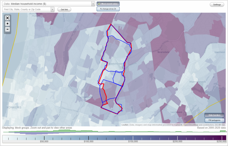
- City boundary
- Neighborhood boundaries
Business Search - 14 Million verified businesses
Neighborhoods:
Bronxville Manor, California Ridge, Lake Isle, Town OutsideBronxville Manor neighborhood in Eastchester statistics: (Find on map)
Area: 0.736 square miles
Population: 4,367
Population density:
Median household income in 2021:
Median rent in in 2021:
Male vs Females
Median age
Housing prices:
Average estimated value of detached houses in 2021 (86.2% of all units):
Average estimated value of townhouses or other attached units in 2021 (5.0% of all units):
Average estimated '21 value of housing units in 5-or-more-unit structures (151.6% of all units):
Most popular occupations of males: business and financial operations occupations (21.4%); management occupations (except farmers) (18.8%); sales and office occupations (18.8%); service occupations (15.4%); computer and mathematical occupations (6.5%); healthcare practitioners and technical occupations (4.8%); legal occupations (3.5%)
Most popular occupations of females: sales and office occupations (28.4%); management occupations (except farmers) (19.3%); education, training, and library occupations (17.9%); business and financial operations occupations (10.2%); healthcare practitioners and technical occupations (5.9%); community and social services occupations (5.3%); arts, design, entertainment, sports, and media occupations (4.1%)
Limited-access highways (interstate or state) in this neighborhood: Hutchinson River Pkwy.
Highways in this neighborhood: State Hwy 22 (White Plains Rd); White Plains Rd (22, State Hwy 22).
Roads and streets: Highland Ave; North Rd; Rose Ave; Middle Rd; Siwanoy Blvd; Ridge St; California Rd; Crawford St; Stebbins Ave; Dusenberry Rd; Overlook Ave; Waverly Ave; Beech St; Deerfield Ave; Archer Pl; Courseview Rd; Edgewood Ln; Winslow Cir; Rittenhouse Rd; Pondfield Rd; Fordal Rd; Elm Ln; Siwanoy Clubway; Summit St; Everett St; Prospect Ave; Paddington Rd; Crawford Dr; South Rd; Forest Ln; Ridgecroft Rd; Paddington Cir; Middleton Pl; Grove Ln; York Pl; Lieb Pl; Manor Rd; Alder Ln; Howell Pl; Barbara Pl; Leticia Rd; Pine Cir; Tara Way; Cannon Ln; Dusenberry Pl; Ridge Croft Rd.
Other features: Hutchinson Riv.
Bronxville Manor neighborhood detailed profile
Area: 0.736 square miles
Population: 4,367
Population density:
| Bronxville Manor (Bronxville): | 5,936 people per square mile |
| Eastchester: | 6,161 people per square mile |
Median household income in 2021:
| Bronxville Manor (Bronxville): | $221,960 |
| Eastchester: | $141,836 |
Median rent in in 2021:
| Bronxville Manor (Bronxville): | $2,405 |
| Eastchester: | $1,902 |
Male vs Females
| Males: | 2,094 |
| Females: | 2,273 |
Median age
| Males: | 39.4 years |
| Females: | 37.7 years |
Housing prices:
Average estimated value of detached houses in 2021 (86.2% of all units):
| Bronxville Manor (Bronxville): | $895,742 |
| New York: | $441,759 |
Average estimated value of townhouses or other attached units in 2021 (5.0% of all units):
| This neighborhood: | $1,331,034 |
| New York: | $658,853 |
Average estimated '21 value of housing units in 5-or-more-unit structures (151.6% of all units):
| Bronxville Manor (Bronxville): | $476,667 |
| New York: | $784,206 |
Most popular occupations of males: business and financial operations occupations (21.4%); management occupations (except farmers) (18.8%); sales and office occupations (18.8%); service occupations (15.4%); computer and mathematical occupations (6.5%); healthcare practitioners and technical occupations (4.8%); legal occupations (3.5%)
Most popular occupations of females: sales and office occupations (28.4%); management occupations (except farmers) (19.3%); education, training, and library occupations (17.9%); business and financial operations occupations (10.2%); healthcare practitioners and technical occupations (5.9%); community and social services occupations (5.3%); arts, design, entertainment, sports, and media occupations (4.1%)
Limited-access highways (interstate or state) in this neighborhood: Hutchinson River Pkwy.
Highways in this neighborhood: State Hwy 22 (White Plains Rd); White Plains Rd (22, State Hwy 22).
Roads and streets: Highland Ave; North Rd; Rose Ave; Middle Rd; Siwanoy Blvd; Ridge St; California Rd; Crawford St; Stebbins Ave; Dusenberry Rd; Overlook Ave; Waverly Ave; Beech St; Deerfield Ave; Archer Pl; Courseview Rd; Edgewood Ln; Winslow Cir; Rittenhouse Rd; Pondfield Rd; Fordal Rd; Elm Ln; Siwanoy Clubway; Summit St; Everett St; Prospect Ave; Paddington Rd; Crawford Dr; South Rd; Forest Ln; Ridgecroft Rd; Paddington Cir; Middleton Pl; Grove Ln; York Pl; Lieb Pl; Manor Rd; Alder Ln; Howell Pl; Barbara Pl; Leticia Rd; Pine Cir; Tara Way; Cannon Ln; Dusenberry Pl; Ridge Croft Rd.
Other features: Hutchinson Riv.
Bronxville Manor neighborhood detailed profile
California Ridge neighborhood in Eastchester statistics: (Find on map)
Area: 0.285 square miles
Population: 1,723
Population density:
Median household income in 2021:
Median rent in in 2021:
Male vs Females
Median age
Housing prices:
Average estimated value of detached houses in 2021 (78.4% of all units):
Average estimated value of housing units in 2-unit structures in 2021 (5.4% of all units):
Most popular occupations of males: management occupations (except farmers) (14.9%); business and financial operations occupations (14.6%); sales and office occupations (14.4%); service occupations (10.3%); healthcare practitioners and technical occupations (9.9%); legal occupations (8.8%); arts, design, entertainment, sports, and media occupations (5.6%)
Most popular occupations of females: education, training, and library occupations (30.2%); management occupations (except farmers) (18.5%); sales and office occupations (15.7%); business and financial operations occupations (11.3%); healthcare practitioners and technical occupations (10.2%); community and social services occupations (5.6%); architecture and engineering occupations (4.2%)
Roads and streets: Mill Rd (82); California Rd; Interlaken Dr; Claudet Way; Forbes Blvd; Longview Dr; Hickory Hill Rd; Soundview Dr; Columbus Cir; Buena Vista Rd; Bevan Pl; Dorchester Rd; Crossway Rd; Bruce Ln; Santa Monica Dr; Joan Dr; Berkley Cir; Waterside Close.
California Ridge neighborhood detailed profile
Area: 0.285 square miles
Population: 1,723
Population density:
| California Ridge: | 6,042 people per square mile |
| Eastchester: | 6,161 people per square mile |
Median household income in 2021:
| California Ridge: | $130,254 |
| Eastchester: | $141,836 |
Median rent in in 2021:
| California Ridge: | $1,753 |
| Eastchester: | $1,902 |
Male vs Females
| Males: | 908 |
| Females: | 815 |
Median age
| Males: | 33.9 years |
| Females: | 40.2 years |
Housing prices:
Average estimated value of detached houses in 2021 (78.4% of all units):
| California Ridge: | $714,867 |
| New York: | $441,759 |
Average estimated value of housing units in 2-unit structures in 2021 (5.4% of all units):
| This neighborhood: | $615,323 |
| New York: | $655,904 |
Most popular occupations of males: management occupations (except farmers) (14.9%); business and financial operations occupations (14.6%); sales and office occupations (14.4%); service occupations (10.3%); healthcare practitioners and technical occupations (9.9%); legal occupations (8.8%); arts, design, entertainment, sports, and media occupations (5.6%)
Most popular occupations of females: education, training, and library occupations (30.2%); management occupations (except farmers) (18.5%); sales and office occupations (15.7%); business and financial operations occupations (11.3%); healthcare practitioners and technical occupations (10.2%); community and social services occupations (5.6%); architecture and engineering occupations (4.2%)
Roads and streets: Mill Rd (82); California Rd; Interlaken Dr; Claudet Way; Forbes Blvd; Longview Dr; Hickory Hill Rd; Soundview Dr; Columbus Cir; Buena Vista Rd; Bevan Pl; Dorchester Rd; Crossway Rd; Bruce Ln; Santa Monica Dr; Joan Dr; Berkley Cir; Waterside Close.
California Ridge neighborhood detailed profile
Lake Isle neighborhood in Eastchester statistics: (Find on map)
Area: 1.590 square miles
Population: 13,485
Population density:
Median household income in 2021:
Median rent in in 2021:
Male vs Females
Median age
Housing prices:
Average estimated value of detached houses in 2021 (65.8% of all units):
Average estimated value of housing units in 2-unit structures in 2021 (7.8% of all units):
Most popular occupations of males: sales and office occupations (19.2%); management occupations (except farmers) (16.0%); service occupations (12.4%); business and financial operations occupations (10.7%); construction, extraction, and maintenance occupations (8.3%); healthcare practitioners and technical occupations (7.5%); legal occupations (4.8%)
Most popular occupations of females: sales and office occupations (29.2%); education, training, and library occupations (22.8%); management occupations (except farmers) (13.2%); healthcare practitioners and technical occupations (11.0%); service occupations (8.4%); business and financial operations occupations (5.7%); arts, design, entertainment, sports, and media occupations (3.8%)
Highways in this neighborhood: State Hwy 22 (White Plains Rd, Post Rd); White Plains Rd (State Hwy 22).
Roads and streets: 82 (Mill Rd); Lake Shore Dr (Lakeshore Dr); California Rd; 2 (Harney Rd); Wilmot Rd (New Wilmot Rd, 113); Leewood Dr; Park Dr; Vernon Dr; Lincoln Ave; Locust Ave; Park Ave; Stratford Rd; Maple St; Cemetery Ln; Old Wilmot Rd; Anpell Dr; Hilburn Rd; Lawrence Ave; Dale Rd; Hutchinson Blvd; Oakland Ave; Manchester Rd; Stewart Pl; Fairway Dr; Waterside Close; Downer Ave; Country Club Rd; Scarsdale Ave; Tudor Ln; Parkway Cir; Summerfield St; Orchard St; Burnham Rd; Crest Ave; Bradley Rd; Bronson Ave; Benedict Ave; Dogwood Dr; Lyons Rd; Water St; Webster Rd; Lincoln Pl; Nelson Rd; Madison Rd; Hunter Dr; Wildwood Rd; Rescigno Dr; Myrtle Pl; Dell Dr; Stewart Ave; Warwick Ave; Knollwood Rd; Laurel Pl; Winding Ln; Johnson Rd; Rutgers Pl; Sylvan Ave; Cloverdale Rd; Brassie Rd; Greenvale Pl; Elba Pl; Ackerman Pl; Arlington Rd; Vassar Pl; Channing Pl; Maple Ave; Ray Pl; Lorraine Dr; Whitehall Rd; Reynolds Pl; White Rd; Shady Ln; Club Way; Lamesa Ave; Hayes Dr; Highview Ave; Dunwoodie St; Hilldale Pl; Woodlot Rd; Cross Hill Rd; Sunnyside Ter; Bell Rd; D'Alessio Ct; Boulder Ln; Jewell Pl; Wildway; Bronx River Pkwy; Oakridge Pl; Parsons Pl; Fernway; Lake Shore Dr N; William St (Gabriel Rescigno Dr); Gaylor Rd; Oak Ln E; Clarence Rd; Crosshill Rd; Echo Ln; Field End Ln; Timmons Rd; Wilton Rd; Hanfling Rd; Innesfree Pl; Swift Ave; Willa Way; Cedar Pl; Apple Ct; Hillary Way; End Pl; Eton Pl; Carrie Pl; Leewood Cir; Birnham Rd.
Railroad features: Conrail RR; Metro-North Commuter RR.
Other features: Hutchinson Riv; Bronx Riv.
Lake Isle neighborhood detailed profile
Area: 1.590 square miles
Population: 13,485
Population density:
| Lake Isle: | 8,480 people per square mile |
| Eastchester: | 6,161 people per square mile |
Median household income in 2021:
| Lake Isle: | $152,078 |
| Eastchester: | $141,836 |
Median rent in in 2021:
| Lake Isle: | $1,901 |
| Eastchester: | $1,902 |
Male vs Females
| Males: | 6,552 |
| Females: | 6,933 |
Median age
| Males: | 41.4 years |
| Females: | 48.0 years |
Housing prices:
Average estimated value of detached houses in 2021 (65.8% of all units):
| Lake Isle: | $792,447 |
| New York: | $441,759 |
Average estimated value of housing units in 2-unit structures in 2021 (7.8% of all units):
| This neighborhood: | $615,323 |
| New York: | $655,904 |
Most popular occupations of males: sales and office occupations (19.2%); management occupations (except farmers) (16.0%); service occupations (12.4%); business and financial operations occupations (10.7%); construction, extraction, and maintenance occupations (8.3%); healthcare practitioners and technical occupations (7.5%); legal occupations (4.8%)
Most popular occupations of females: sales and office occupations (29.2%); education, training, and library occupations (22.8%); management occupations (except farmers) (13.2%); healthcare practitioners and technical occupations (11.0%); service occupations (8.4%); business and financial operations occupations (5.7%); arts, design, entertainment, sports, and media occupations (3.8%)
Highways in this neighborhood: State Hwy 22 (White Plains Rd, Post Rd); White Plains Rd (State Hwy 22).
Roads and streets: 82 (Mill Rd); Lake Shore Dr (Lakeshore Dr); California Rd; 2 (Harney Rd); Wilmot Rd (New Wilmot Rd, 113); Leewood Dr; Park Dr; Vernon Dr; Lincoln Ave; Locust Ave; Park Ave; Stratford Rd; Maple St; Cemetery Ln; Old Wilmot Rd; Anpell Dr; Hilburn Rd; Lawrence Ave; Dale Rd; Hutchinson Blvd; Oakland Ave; Manchester Rd; Stewart Pl; Fairway Dr; Waterside Close; Downer Ave; Country Club Rd; Scarsdale Ave; Tudor Ln; Parkway Cir; Summerfield St; Orchard St; Burnham Rd; Crest Ave; Bradley Rd; Bronson Ave; Benedict Ave; Dogwood Dr; Lyons Rd; Water St; Webster Rd; Lincoln Pl; Nelson Rd; Madison Rd; Hunter Dr; Wildwood Rd; Rescigno Dr; Myrtle Pl; Dell Dr; Stewart Ave; Warwick Ave; Knollwood Rd; Laurel Pl; Winding Ln; Johnson Rd; Rutgers Pl; Sylvan Ave; Cloverdale Rd; Brassie Rd; Greenvale Pl; Elba Pl; Ackerman Pl; Arlington Rd; Vassar Pl; Channing Pl; Maple Ave; Ray Pl; Lorraine Dr; Whitehall Rd; Reynolds Pl; White Rd; Shady Ln; Club Way; Lamesa Ave; Hayes Dr; Highview Ave; Dunwoodie St; Hilldale Pl; Woodlot Rd; Cross Hill Rd; Sunnyside Ter; Bell Rd; D'Alessio Ct; Boulder Ln; Jewell Pl; Wildway; Bronx River Pkwy; Oakridge Pl; Parsons Pl; Fernway; Lake Shore Dr N; William St (Gabriel Rescigno Dr); Gaylor Rd; Oak Ln E; Clarence Rd; Crosshill Rd; Echo Ln; Field End Ln; Timmons Rd; Wilton Rd; Hanfling Rd; Innesfree Pl; Swift Ave; Willa Way; Cedar Pl; Apple Ct; Hillary Way; End Pl; Eton Pl; Carrie Pl; Leewood Cir; Birnham Rd.
Railroad features: Conrail RR; Metro-North Commuter RR.
Other features: Hutchinson Riv; Bronx Riv.
Lake Isle neighborhood detailed profile
Town Outside neighborhood in Eastchester statistics: (Find on map)
Area: 3.704 square miles
Population: 31,188
Population density:
Median household income in 2021:
Median rent in in 2021:
Male vs Females
Median age
Housing prices:
Average estimated value of detached houses in 2021 (60.2% of all units):
Average estimated value of townhouses or other attached units in 2021 (5.4% of all units):
Average estimated value of housing units in 2-unit structures in 2021 (6.3% of all units):
Average estimated '21 value of housing units in 5-or-more-unit structures (58.1% of all units):
Most popular occupations of males: management occupations (except farmers) (19.1%); sales and office occupations (18.0%); business and financial operations occupations (13.5%); service occupations (13.0%); healthcare practitioners and technical occupations (6.5%); construction, extraction, and maintenance occupations (5.5%); legal occupations (5.4%)
Most popular occupations of females: sales and office occupations (24.1%); education, training, and library occupations (19.5%); management occupations (except farmers) (19.0%); healthcare practitioners and technical occupations (8.9%); business and financial operations occupations (7.6%); service occupations (5.8%); arts, design, entertainment, sports, and media occupations (4.9%)
Limited-access highways (interstate or state) in this neighborhood: 907W (Hutchinson River Pkwy); 907K (Cross County Pkwy).
Highways in this neighborhood: State Hwy 22 (White Plains Rd); State Hwy 22 (White Plains Rd, Post Rd); White Plains Rd (22, State Hwy 22).
Roads and streets: California Rd; New Rochelle Rd; 82 (Mill Rd); Lake Shore Dr (Lakeshore Dr); Garth Rd; Highland Ave; 2 (Harney Rd); Wilmot Rd (New Wilmot Rd, 113); Leewood Dr; Scarsdale Ave; North Rd; Rose Ave; Hewitt Ave; Marbledale Rd; Park Dr; Woodruff Ave; Middle Rd; Vernon Dr; Lincoln Ave; Tuckahoe Ave; Park Ave; Joyce Rd; Siwanoy Blvd; Locust Ave; Ridge St; Northway; Crawford St; Stratford Rd; Howard Ave; Alkamont Ave; Anderson Ave; Hickory Hill Rd; 69 (Midland Ave); Lakeview Ave; Maple St; Stebbins Ave; Interlaken Dr; Claudet Way; Parkview Dr; Bronx River Pkwy; Cemetery Ln; Forbes Blvd; Gray Rock Rd; Grand Blvd; Old Wilmot Rd; Lockwood Ave; Montgomery Ave; Longview Dr; Dunwoodie St; Anpell Dr; Hilburn Rd; Lawrence Ave; Dusenberry Rd; Webster Rd; Dale Rd; Hathaway Rd; Hutchinson Blvd; Overlook Ave; Oakland Ave; Alida St; Ewart St; Manchester Rd; Stewart Pl; Waverly Ave; Fairway Dr; Archer Dr; Beech St; Lee Ave; Lyons Rd; Oregon Ave; Nelson Rd; Waterside Close; Homestead Rd (Homestead Ave); Deerfield Ave; Downer Ave; Lispenard Ave; Gaylor Rd; Archer Pl; Country Club Rd; Courseview Rd; Madison Rd; Bell Rd; Tudor Ln; Parkway Cir; Edgewood Ln; Summerfield St; Orchard St; Main St (37); Burnham Rd; Soundview Dr; Maple Ave; Fisher Ave; Crest Ave; Dorchester Rd; Winslow Cir; Columbus Cir; Johnson Rd; Jackson Ave; Hilltop Rd; Bradley Rd; Buena Vista Rd; Cypress Rd; Bronson Ave; Benedict Ave; Glen Rd; Dogwood Dr; Eastway; Water St; Rittenhouse Rd; Hall Ave; Lincoln Pl; White Rd; Morgan St; Huntley Rd; Pondfield Rd; New St; Fordal Rd; Hunter Dr; Hillside Pl; Midland Ave; Wildwood Rd; Rescigno Dr; Myrtle Pl; Dell Dr; Elm Ln; Central Dr; Winter Hill Rd; Stewart Ave; Brambach Ave (Brambach Rd); Warwick Ave; Prospect Ave; Pasadena Rd; Colonial Rd; Knollwood Rd; Laurel Pl; Merritt Ave; Winding Ln; Bellew Ave; Rutgers Pl; Siwanoy Clubway; Sylvan Ave; Greenmeadow Rd; Cloverdale Rd; Wright Pl; Douglas Pl; Southway; Summit St; Hillside Rd; Brassie Rd; Knox Rd; Everett St; Westway; Leslie Rd; Overhill Rd; Greystone Cir; Greenvale Pl; Elba Pl; Ackerman Pl; Arlington Rd; Vassar Pl; Foothill Rd; Southeastway; Paddington Rd; Crawford Dr; South Rd; Andrew Rd; Channing Pl; Ray Pl; Lorraine Dr; John R Albanese Pl; Whitehall Rd; Reynolds Pl; Forest Ln; Shady Ln; Ridgecroft Rd; Franklin St; Club Way; Lamesa Ave; Hayes Dr; Paddington Cir; Middleton Pl; Highview Ave; Hubbard Cir; Darcy Ln; Hilldale Pl; Woodlot Rd; Cross Hill Rd; Sunnyside Ter; Bevan Pl; Wendover Rd; Grove Ln; D'Alessio Ct; Boulder Ln; Potter Rd (Potter Pl); Brookridge Ave; Charles Pl; Leary St; Parkway Plz; York Pl; Jewell Pl; Wildway; Roy Pl; Corwood Rd; Allaire St; Oakridge Pl; Parsons Pl; Franklin Pl; Fernway; Lake Shore Dr N; William St (Gabriel Rescigno Dr); Lieb Pl; Oak Ln E; Buffington Pl; Caldwell St; Manor Rd; Buckingham Pl; Clarence Rd; Crosshill Rd; Echo Ln; Elmsmere Rd; Field End Ln; Timmons Rd; Brothers Cir; Wilton Rd; Hanfling Rd; Allen Pl; Innesfree Pl; Thomas Pl; Mortimer Pl; Mayfair Rd (Michael Frey Dr); Swift Ave; Dempsey Pl; Alder Ln; Willa Way; Alexander Pl; Cedar Pl; Meredith Pl (Meredith Ave); Northwest Way; Sprague Ave; Apple Ct; Howell Pl; Crossway Rd; Bruce Ln; Barbara Pl; Hillary Way; Hall Pl; Santa Monica Dr; Nancy Pl; 4th St; Richardson Pl; Joan Dr; Ann Pl; Chester Pl; Essex Pl; Leticia Rd; Lucille Pl; Duluth Pl; Berkley Cir; Pine Cir; End Pl; Michael Frey Dr; Hillcrest Rd; Eton Pl; Carrie Pl; Sage Pl; Robbins Rd; Tara Way; Cannon Ln; Dusenberry Pl; Carolyn Pl; Maybrook Cir; Dean Pl; Henry St; Leewood Cir; Ivy Pl; Birnham Rd; Grissom Dr; Ridge Croft Rd.
Railroad features: Conrail RR; Metro-North Commuter RR.
Other features: Hutchinson Riv; Bronx Riv; Twin Lake No 2.
Town Outside neighborhood detailed profile
Area: 3.704 square miles
Population: 31,188
Population density:
| Town Outside: | 8,420 people per square mile |
| Eastchester: | 6,161 people per square mile |
Median household income in 2021:
| Town Outside: | $187,966 |
| Eastchester: | $141,836 |
Median rent in in 2021:
| Town Outside: | $2,006 |
| Eastchester: | $1,902 |
Male vs Females
| Males: | 14,917 |
| Females: | 16,271 |
Median age
| Males: | 39.8 years |
| Females: | 43.3 years |
Housing prices:
Average estimated value of detached houses in 2021 (60.2% of all units):
| Town Outside: | $835,246 |
| New York: | $441,759 |
Average estimated value of townhouses or other attached units in 2021 (5.4% of all units):
| This neighborhood: | $1,229,739 |
| New York: | $658,853 |
Average estimated value of housing units in 2-unit structures in 2021 (6.3% of all units):
| This neighborhood: | $615,323 |
| New York: | $655,904 |
Average estimated '21 value of housing units in 5-or-more-unit structures (58.1% of all units):
| Town Outside: | $370,521 |
| New York: | $784,206 |
Most popular occupations of males: management occupations (except farmers) (19.1%); sales and office occupations (18.0%); business and financial operations occupations (13.5%); service occupations (13.0%); healthcare practitioners and technical occupations (6.5%); construction, extraction, and maintenance occupations (5.5%); legal occupations (5.4%)
Most popular occupations of females: sales and office occupations (24.1%); education, training, and library occupations (19.5%); management occupations (except farmers) (19.0%); healthcare practitioners and technical occupations (8.9%); business and financial operations occupations (7.6%); service occupations (5.8%); arts, design, entertainment, sports, and media occupations (4.9%)
Limited-access highways (interstate or state) in this neighborhood: 907W (Hutchinson River Pkwy); 907K (Cross County Pkwy).
Highways in this neighborhood: State Hwy 22 (White Plains Rd); State Hwy 22 (White Plains Rd, Post Rd); White Plains Rd (22, State Hwy 22).
Roads and streets: California Rd; New Rochelle Rd; 82 (Mill Rd); Lake Shore Dr (Lakeshore Dr); Garth Rd; Highland Ave; 2 (Harney Rd); Wilmot Rd (New Wilmot Rd, 113); Leewood Dr; Scarsdale Ave; North Rd; Rose Ave; Hewitt Ave; Marbledale Rd; Park Dr; Woodruff Ave; Middle Rd; Vernon Dr; Lincoln Ave; Tuckahoe Ave; Park Ave; Joyce Rd; Siwanoy Blvd; Locust Ave; Ridge St; Northway; Crawford St; Stratford Rd; Howard Ave; Alkamont Ave; Anderson Ave; Hickory Hill Rd; 69 (Midland Ave); Lakeview Ave; Maple St; Stebbins Ave; Interlaken Dr; Claudet Way; Parkview Dr; Bronx River Pkwy; Cemetery Ln; Forbes Blvd; Gray Rock Rd; Grand Blvd; Old Wilmot Rd; Lockwood Ave; Montgomery Ave; Longview Dr; Dunwoodie St; Anpell Dr; Hilburn Rd; Lawrence Ave; Dusenberry Rd; Webster Rd; Dale Rd; Hathaway Rd; Hutchinson Blvd; Overlook Ave; Oakland Ave; Alida St; Ewart St; Manchester Rd; Stewart Pl; Waverly Ave; Fairway Dr; Archer Dr; Beech St; Lee Ave; Lyons Rd; Oregon Ave; Nelson Rd; Waterside Close; Homestead Rd (Homestead Ave); Deerfield Ave; Downer Ave; Lispenard Ave; Gaylor Rd; Archer Pl; Country Club Rd; Courseview Rd; Madison Rd; Bell Rd; Tudor Ln; Parkway Cir; Edgewood Ln; Summerfield St; Orchard St; Main St (37); Burnham Rd; Soundview Dr; Maple Ave; Fisher Ave; Crest Ave; Dorchester Rd; Winslow Cir; Columbus Cir; Johnson Rd; Jackson Ave; Hilltop Rd; Bradley Rd; Buena Vista Rd; Cypress Rd; Bronson Ave; Benedict Ave; Glen Rd; Dogwood Dr; Eastway; Water St; Rittenhouse Rd; Hall Ave; Lincoln Pl; White Rd; Morgan St; Huntley Rd; Pondfield Rd; New St; Fordal Rd; Hunter Dr; Hillside Pl; Midland Ave; Wildwood Rd; Rescigno Dr; Myrtle Pl; Dell Dr; Elm Ln; Central Dr; Winter Hill Rd; Stewart Ave; Brambach Ave (Brambach Rd); Warwick Ave; Prospect Ave; Pasadena Rd; Colonial Rd; Knollwood Rd; Laurel Pl; Merritt Ave; Winding Ln; Bellew Ave; Rutgers Pl; Siwanoy Clubway; Sylvan Ave; Greenmeadow Rd; Cloverdale Rd; Wright Pl; Douglas Pl; Southway; Summit St; Hillside Rd; Brassie Rd; Knox Rd; Everett St; Westway; Leslie Rd; Overhill Rd; Greystone Cir; Greenvale Pl; Elba Pl; Ackerman Pl; Arlington Rd; Vassar Pl; Foothill Rd; Southeastway; Paddington Rd; Crawford Dr; South Rd; Andrew Rd; Channing Pl; Ray Pl; Lorraine Dr; John R Albanese Pl; Whitehall Rd; Reynolds Pl; Forest Ln; Shady Ln; Ridgecroft Rd; Franklin St; Club Way; Lamesa Ave; Hayes Dr; Paddington Cir; Middleton Pl; Highview Ave; Hubbard Cir; Darcy Ln; Hilldale Pl; Woodlot Rd; Cross Hill Rd; Sunnyside Ter; Bevan Pl; Wendover Rd; Grove Ln; D'Alessio Ct; Boulder Ln; Potter Rd (Potter Pl); Brookridge Ave; Charles Pl; Leary St; Parkway Plz; York Pl; Jewell Pl; Wildway; Roy Pl; Corwood Rd; Allaire St; Oakridge Pl; Parsons Pl; Franklin Pl; Fernway; Lake Shore Dr N; William St (Gabriel Rescigno Dr); Lieb Pl; Oak Ln E; Buffington Pl; Caldwell St; Manor Rd; Buckingham Pl; Clarence Rd; Crosshill Rd; Echo Ln; Elmsmere Rd; Field End Ln; Timmons Rd; Brothers Cir; Wilton Rd; Hanfling Rd; Allen Pl; Innesfree Pl; Thomas Pl; Mortimer Pl; Mayfair Rd (Michael Frey Dr); Swift Ave; Dempsey Pl; Alder Ln; Willa Way; Alexander Pl; Cedar Pl; Meredith Pl (Meredith Ave); Northwest Way; Sprague Ave; Apple Ct; Howell Pl; Crossway Rd; Bruce Ln; Barbara Pl; Hillary Way; Hall Pl; Santa Monica Dr; Nancy Pl; 4th St; Richardson Pl; Joan Dr; Ann Pl; Chester Pl; Essex Pl; Leticia Rd; Lucille Pl; Duluth Pl; Berkley Cir; Pine Cir; End Pl; Michael Frey Dr; Hillcrest Rd; Eton Pl; Carrie Pl; Sage Pl; Robbins Rd; Tara Way; Cannon Ln; Dusenberry Pl; Carolyn Pl; Maybrook Cir; Dean Pl; Henry St; Leewood Cir; Ivy Pl; Birnham Rd; Grissom Dr; Ridge Croft Rd.
Railroad features: Conrail RR; Metro-North Commuter RR.
Other features: Hutchinson Riv; Bronx Riv; Twin Lake No 2.
Town Outside neighborhood detailed profile