Airport Hills neighborhood in Birmingham, Alabama (AL), 35206, 35215, 35217 detailed profile
Settings
X

Business Search - 14 Million verified businesses
Area: 3.852 square miles
Population: 7,296
Population density:
| Airport Hills: | 1,894 people per square mile |
| Birmingham: | 1,310 people per square mile |

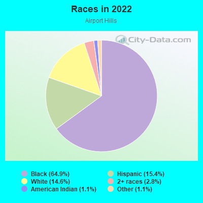
- 5,02764.9%Black
- 1,19515.4%Hispanic or Latino
- 1,13014.6%White
- 2162.8%Two or more races
- 891.1%American Indian
- 841.1%Some other race
Median household income in 2022:
| Airport Hills: | $45,661 |
| Birmingham: | $39,326 |
Distribution of median household income
![Distribution of median household income]()
- 156Less than $10,000
- 577$10,000 to $19,999
- 603$20,000 to $29,999
- 563$30,000 to $39,999
- 609$40,000 to $49,999
- 192$50,000 to $59,999
- 556$60,000 to $74,999
- 370$75,000 to $99,999
- 130$100,000 to $124,999
- 260$125,000 to $149,999
- 119$150,000 to $199,999
- 163$200,000 or more

Distribution of owner-occupied house/condo value
![Distribution of owner-occupied house/condo value]()
- 955Less than $50,000
- 904$50,000 to $99,999
- 758$100,000 to $149,999
- 709$150,000 to $199,999
- 260$200,000 to $249,999
- 154$250,000 to $299,999
- 31$300,000 to $399,999
- 276$500,000 to $749,999

Distribution of rent paid by renters
![Distribution of rent paid by renters]()
- 653Less than $100
- 396$100 to $199
- 2,273$200 to $299
- 544$300 to $399
- 771$400 to $499
- 612$500 to $599
- 1,419$600 to $699
- 633$700 to $799
- 332$800 to $899
- 93$900 to $999
- 216$1,000 to $1,249

Median rent in 2022:
| Airport Hills: | $709 |
| Birmingham: | $753 |
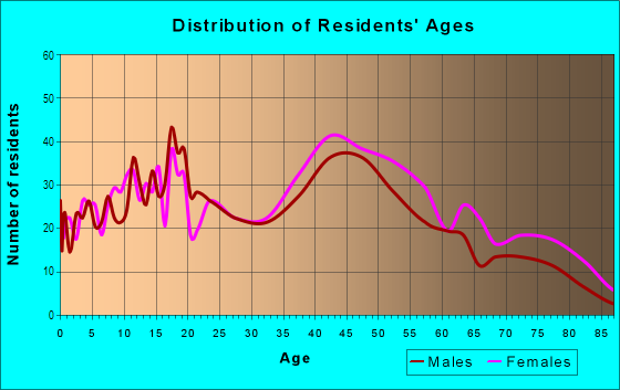
| Males: | 3,834 |
| Females: | 3,461 |
Males:
| This neighborhood: | 42.3 years |
| Whole city: | 34.5 years |
| This neighborhood: | 51.2 years |
| Whole city: | 35.9 years |
Average household size:
| Airport Hills: | 14.9 people |
| Birmingham: | 27.0 people |
Percentage of family households:
| Airport Hills: | 42.4% |
| Birmingham: | 32.5% |
| Here: | 27.4% |
| Birmingham: | 21.4% |
Percentage of married-couple families with children (among all households):
| Airport Hills: | 29.0% |
| Birmingham: | 14.3% |
Percentage of single-mother households (among all households):
| Airport Hills: | 20.6% |
| Birmingham: | 29.7% |
Percentage of never married males 15 years old and over:
Percentage of never married females 15 years old and over:
| Airport Hills: | 32.5% |
| Birmingham: | 24.0% |
Percentage of never married females 15 years old and over:
| Airport Hills: | 15.9% |
| city: | 26.4% |
Percentage of people that speak English not well or not at all:
| Airport Hills: | 10.0% |
| Birmingham: | 1.1% |
Percentage of people born in this state:
Percentage of people born in another U.S. state:
Percentage of native residents but born outside the U.S.:
Percentage of foreign born residents:
| Here: | 76.3% |
| Birmingham: | 76.8% |
Percentage of people born in another U.S. state:
| Airport Hills: | 16.1% |
| Birmingham: | 18.6% |
Percentage of native residents but born outside the U.S.:
| Here: | 1.0% |
| city: | 0.7% |
Percentage of foreign born residents:
| Here: | 7.4% |
| Birmingham: | 3.9% |
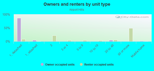
Owner-occupied
Renter-occupied

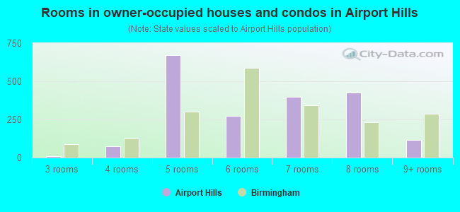
- Rooms in owner-occupied houses and condos in Airport Hills
- 01 room
- 02 rooms
- 73 rooms
- 764 rooms
- 6715 rooms
- 2756 rooms
- 3967 rooms
- 4268 rooms
- 1169+ rooms
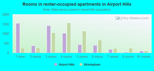
- Rooms in renter-occupied apartments in Airport Hills
- 1,5461 room
- 3722 rooms
- 1,4153 rooms
- 1,0274 rooms
- 4275 rooms
- 3986 rooms
- 1877 rooms
- 358 rooms
- 939+ rooms
Owner-occupied
Renter-occupied
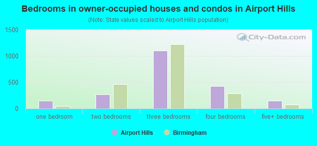
- Bedrooms in owner-occupied houses and condos in Airport Hills
- 0no bedroom
- 1471 bedroom
- 2672 bedrooms
- 1,1023 bedrooms
- 4254 bedrooms
- 1515+ bedrooms
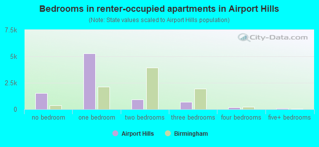
- Bedrooms in renter-occupied apartments in Airport Hills
- 1,546no bedroom
- 5,2901 bedroom
- 9032 bedrooms
- 7063 bedrooms
- 1754 bedrooms
- 935+ bedrooms
Average number of cars or other vehicles available in houses/condos:
Average number of cars or other vehicles available in apartments:
| This neighborhood: | 1.6 |
| Birmingham: | 1.8 |
Average number of cars or other vehicles available in apartments:
| Here: | 1.0 |
| city: | 1.2 |
Percentage of units with a mortgage:
| Airport Hills: | 51.5% |
| Birmingham: | 51.3% |
Average estimated value of detached houses in 2022 (66.5% of all units):
| Airport Hills: | $74,646 |
| Birmingham: | $180,877 |
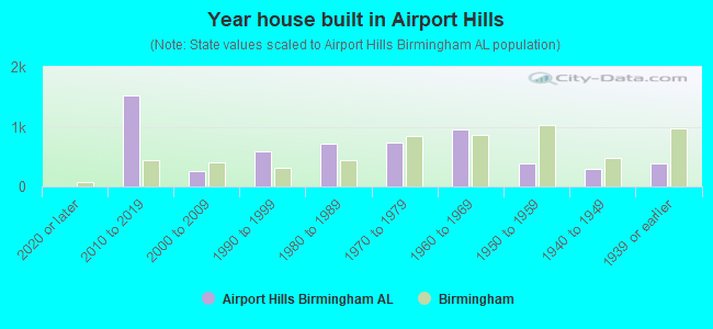
- Year house built in Airport Hills
- 82020 or later
- 1,5272010 to 2019
- 2592000 to 2009
- 5941990 to 1999
- 7161980 to 1989
- 7351970 to 1979
- 9451960 to 1969
- 3821950 to 1959
- 2881940 to 1949
- 3791939 or earlier
City-data.com crime index for city in 2020 (higher means more crime):
| City: | 199.5 |
| U.S. average: | 219.5 |
Travel time to work (commute)
![Travel time to work (commute)]()
- 84Less than 5 minutes
- 2195 to 9 minutes
- 12510 to 14 minutes
- 45515 to 19 minutes
- 50420 to 24 minutes
- 14625 to 29 minutes
- 49530 to 34 minutes
- 5535 to 39 minutes
- 3640 to 44 minutes
- 31645 to 59 minutes
- 12360 to 89 minutes
- 6490 or more minutes

Means of transportation to work
![Means of transportation to work]()
- 63.7%1,985Drove a car alone
- 26.9%838Carpooled
- 49.6%1,546Bus
- 8.3%260Taxi
- 0.4%13Bicycle
- 1.4%44Walked
- 6.9%215Other means
- 3.7%115Worked at home

Time leaving home to go to work
![Time leaving home to go to work]()
- 31112:00 a.m. to 4:59 a.m.
- 1265:00 a.m. to 5:29 a.m.
- 1305:30 a.m. to 5:59 a.m.
- 3476:00 a.m. to 6:29 a.m.
- 2846:30 a.m. to 6:59 a.m.
- 3087:00 a.m. to 7:29 a.m.
- 1367:30 a.m. to 7:59 a.m.
- 1958:00 a.m. to 8:29 a.m.
- 618:30 a.m. to 8:59 a.m.
- 829:00 a.m. to 9:59 a.m.
- 8710:00 a.m. to 10:59 a.m.
- 13311:00 a.m. to 11:59 a.m.
- 17212:00 p.m. to 3:59 p.m.
- 1534:00 p.m. to 11:59 p.m.

Occupations of males:
- Percentage of males in management occupations (except farmers):
Here: 3.6% city: 8.1%
- Percentage of males in business and financial operations occupations:
Here: 2.5% city: 4.8%
- Percentage of males in computer and mathematical occupations:
Here: 2.3% city: 3.7%
- Percentage of males in architecture and engineering occupations:
Here: 4.1% city: 2.2%
- Percentage of males in community and social services occupations:
Here: 3.1% city: 1.5%
- Percentage of males in legal occupations:
Here: 1.2% city: 1.7%
- Percentage of males in education, training, and library occupations:
Here: 1.2% city: 3.1%
- Percentage of males in service occupations:
Here: 18.3% city: 17.4%
- Percentage of males in sales and office occupations:
Here: 1.1% city: 13.7%
- Percentage of males in farming, fishing, and forestry occupations:
Here: 4.6% city: 0.3%
- Percentage of males in construction, extraction, and maintenance occupations:
Here: 12.0% city: 8.3%
- Percentage of males in production occupations:
Here: 35.2% city: 8.0%
- Percentage of males in transportation occupations:
Here: 12.4% city: 6.8%
- Percentage of males in material moving occupations:
Here: 6.8% city: 9.9%
Occupations of females:
- Percentage of females in business and financial operations occupations:
Here: 3.2% city: 5.7%
- Percentage of females in computer and mathematical occupations:
Here: 9.6% city: 1.3%
- Percentage of females in community and social services occupations:
Here: 9.4% city: 2.7%
- Percentage of females in healthcare practitioners and technical occupations:
Here: 8.8% city: 10.0%
- Percentage of females in service occupations:
Here: 25.0% city: 22.1%
- Percentage of females in sales and office occupations:
Here: 29.2% city: 28.0%
- Percentage of females in construction, extraction, and maintenance occupations:
Here: 7.9% city: 0.2%
- Percentage of females in transportation occupations:
Here: 3.8% city: 1.2%
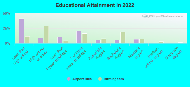
Education in this neighborhood (subdivision or community):
- Percentage of people 3 years and older in K-12 schools:
Airport Hills: 24.9% Birmingham: 13.1%
- Percentage of people 3 years and older in undergraduate colleges:
Airport Hills: 5.0% Birmingham: 7.8%
- Percentage of people 3 years and older in grad. or professional schools:
Airport Hills: 2.2% Birmingham: 2.2%
- Percentage of students K-12 enrolled in private schools:
Airport Hills: 58.3% Birmingham: 11.1%
Percentage of population below poverty level:
| Airport Hills: | 20.0% |
| Birmingham: | 26.6% |
Percentage of married-couple families with both working:
| Airport Hills: | 151.3% |
| Birmingham: | 62.9% |
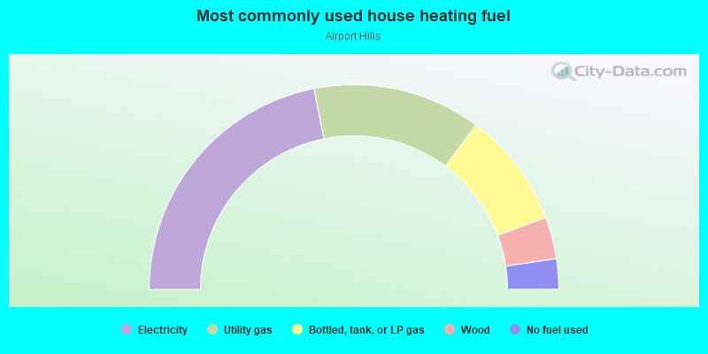
- 43.8%Electricity
- 26.6%Utility gas
- 18.3%Bottled, tank, or LP gas
- 6.6%Wood
- 4.8%No fuel used
Highways in this neighborhood:
State Rte 79 (Pinson Valley Pkwy)
Length: 0.08 miles
Direction: SW-NE
Direction: SW-NE
Roads and streets:
Lawson Rd (Co Rd 154)
Length: 2.02 miles
Directions: E-W, SE-NW
Address range: 400 to 1230
Directions: E-W, SE-NW
Address range: 400 to 1230
Tarrant Huffman Rd (Co Rd 126, Bethel Ave)
Length: 2.02 miles
Directions: E-W, SW-NE
Address range: 600 to 2199
Directions: E-W, SW-NE
Address range: 600 to 2199
Airport Rd
Length: 1.91 miles
Directions: E-W, N-S, SW-NE
Address range: 8500 to 9999
Directions: E-W, N-S, SW-NE
Address range: 8500 to 9999
90th St N
Length: 1.54 miles
Directions: E-W, N-S, SE-NW, SW-NE
Address range: 800 to 6499
Directions: E-W, N-S, SE-NW, SW-NE
Address range: 800 to 6499
91st St N
Length: 1.23 miles
Directions: E-W, N-S, SE-NW
Address range: 500 to 7099
Directions: E-W, N-S, SE-NW
Address range: 500 to 7099
Treadwell Rd
Length: 1.06 miles
Directions: E-W, N-S, SE-NW
Address range: 1700 to 2399
Directions: E-W, N-S, SE-NW
Address range: 1700 to 2399
12th Ave N (Zion City Rd)
Length: 0.96 miles
Directions: N-S, SE-NW, SW-NE
Address range: 8400 to 9399
Directions: N-S, SE-NW, SW-NE
Address range: 8400 to 9399
Willie Payne Dr (88th St N)
Length: 0.96 miles
Directions: E-W, SE-NW
Address range: 700 to 6799
Directions: E-W, SE-NW
Address range: 700 to 6799
90th Pl N
Length: 0.94 miles
Directions: E-W, SE-NW
Address range: 803 to 1799
Directions: E-W, SE-NW
Address range: 803 to 1799
Marshall Ave
Length: 0.93 miles
Directions: E-W, N-S, SW-NE
Address range: 400 to 9651
Directions: E-W, N-S, SW-NE
Address range: 400 to 9651
Red Mill Rd
Length: 0.93 miles
Directions: E-W, N-S, SE-NW
Address range: 100 to 9899
Directions: E-W, N-S, SE-NW
Address range: 100 to 9899
2nd Aly N
Length: 0.90 miles
Directions: E-W, N-S, SE-NW
Directions: E-W, N-S, SE-NW
Westfield Rd
Length: 0.84 miles
Directions: E-W, N-S, SW-NE
Address range: 9400 to 9899
Directions: E-W, N-S, SW-NE
Address range: 9400 to 9899
9th Ave N
Length: 0.82 miles
Direction: N-S
Address range: 8800 to 9699
Direction: N-S
Address range: 8800 to 9699
89th St N
Length: 0.78 miles
Directions: E-W, SE-NW
Address range: 800 to 6699
Directions: E-W, SE-NW
Address range: 800 to 6699
87th St N
Length: 0.76 miles
Directions: E-W, N-S, SE-NW
Address range: 921 to 2099
Directions: E-W, N-S, SE-NW
Address range: 921 to 2099
E Lake Blvd
Length: 0.73 miles
Direction: E-W
Direction: E-W
92nd St N
Length: 0.72 miles
Directions: E-W, N-S, SE-NW
Address range: 520 to 7999
Directions: E-W, N-S, SE-NW
Address range: 520 to 7999
50th Aly N
Length: 0.71 miles
Directions: E-W, N-S
Directions: E-W, N-S
8th Ave N
Length: 0.71 miles
Directions: E-W, N-S
Address range: 8800 to 9499
Directions: E-W, N-S
Address range: 8800 to 9499
57th Ave N
Length: 0.69 miles
Direction: E-W
Address range: 1518 to 6699
Direction: E-W
Address range: 1518 to 6699
17th Ave N
Length: 0.64 miles
Directions: N-S, SW-NE
Address range: 8600 to 9099
Directions: N-S, SW-NE
Address range: 8600 to 9099
7th Ave N
Length: 0.64 miles
Direction: N-S
Address range: 8800 to 9499
Direction: N-S
Address range: 8800 to 9499
21st Aly N
Length: 0.62 miles
Directions: E-W, N-S, SE-NW
Directions: E-W, N-S, SE-NW
56th Ave N (85th St N)
Length: 0.61 miles
Directions: E-W, N-S, SE-NW
Address range: 1100 to 6699
Directions: E-W, N-S, SE-NW
Address range: 1100 to 6699
Co Rd 126 (Roebuck Dr)
Length: 0.58 miles
Directions: N-S, SW-NE
Address range: 20 to 172
Directions: N-S, SW-NE
Address range: 20 to 172
Cedar St
Length: 0.56 miles
Directions: E-W, N-S
Address range: 2000 to 2199
Directions: E-W, N-S
Address range: 2000 to 2199
7th Aly N
Length: 0.56 miles
Directions: E-W, N-S
Directions: E-W, N-S
el Camino Dr
Length: 0.55 miles
Directions: E-W, N-S, SW-NE
Address range: 1000 to 1105
Directions: E-W, N-S, SW-NE
Address range: 1000 to 1105
89th Pl N
Length: 0.54 miles
Direction: E-W
Address range: 1400 to 1999
Direction: E-W
Address range: 1400 to 1999
Evergreen St
Length: 0.53 miles
Direction: E-W
Address range: 218 to 2240
Direction: E-W
Address range: 218 to 2240
Pine St
Length: 0.53 miles
Directions: E-W, N-S
Address range: 1900 to 1999
Directions: E-W, N-S
Address range: 1900 to 1999
90th Aly N
Length: 0.53 miles
Direction: E-W
Direction: E-W
Bates Ave
Length: 0.52 miles
Directions: N-S, SE-NW
Address range: 9900 to 9999
Directions: N-S, SE-NW
Address range: 9900 to 9999
Oak St
Length: 0.52 miles
Directions: E-W, N-S
Address range: 2200 to 2299
Directions: E-W, N-S
Address range: 2200 to 2299
14th Ave N
Length: 0.52 miles
Direction: N-S
Address range: 8800 to 9599
Direction: N-S
Address range: 8800 to 9599
Eastpointe Cir
Length: 0.51 miles
Directions: E-W, N-S, SE-NW, SW-NE
Address range: 9500 to 9661
Directions: E-W, N-S, SE-NW, SW-NE
Address range: 9500 to 9661
31st Aly N
Length: 0.49 miles
Directions: E-W, N-S, SE-NW
Directions: E-W, N-S, SE-NW
Northwood Dr
Length: 0.49 miles
Directions: E-W, N-S, SE-NW, SW-NE
Address range: 800 to 1199
Directions: E-W, N-S, SE-NW, SW-NE
Address range: 800 to 1199
20th Aly N
Length: 0.48 miles
Directions: E-W, N-S, SW-NE
Directions: E-W, N-S, SW-NE
Penfield Dr
Length: 0.48 miles
Directions: E-W, N-S, SW-NE
Address range: 902 to 1199
Directions: E-W, N-S, SW-NE
Address range: 902 to 1199
39th Aly N
Length: 0.47 miles
Directions: E-W, N-S
Directions: E-W, N-S
Westfield Ct
Length: 0.46 miles
Directions: E-W, N-S, SE-NW, SW-NE
Address range: 9808 to 9899
Directions: E-W, N-S, SE-NW, SW-NE
Address range: 9808 to 9899
38th Aly N
Length: 0.46 miles
Direction: E-W
Direction: E-W
99th St N
Length: 0.46 miles
Direction: E-W
Address range: 1300 to 1799
Direction: E-W
Address range: 1300 to 1799
Co Rd 126 (96th St N)
Length: 0.44 miles
Direction: E-W
Address range: 1 to 399
Direction: E-W
Address range: 1 to 399
86th St N
Length: 0.44 miles
Direction: E-W
Address range: 900 to 1099
Direction: E-W
Address range: 900 to 1099
8th Ct N
Length: 0.42 miles
Direction: N-S
Address range: 8800 to 9299
Direction: N-S
Address range: 8800 to 9299
37th Aly N
Length: 0.41 miles
Direction: E-W
Direction: E-W
Zion Dr
Length: 0.41 miles
Directions: E-W, SW-NE
Directions: E-W, SW-NE
18th Ave N
Length: 0.40 miles
Direction: N-S
Direction: N-S
93rd St N
Length: 0.40 miles
Directions: E-W, SE-NW
Address range: 402 to 1299
Directions: E-W, SE-NW
Address range: 402 to 1299
Weatherly Ave
Length: 0.39 miles
Direction: E-W
Address range: 2001 to 2199
Direction: E-W
Address range: 2001 to 2199
3rd Aly N
Length: 0.39 miles
Direction: N-S
Direction: N-S
Zion City Rd
Length: 0.38 miles
Directions: N-S, SE-NW
Address range: 9400 to 9723
Directions: N-S, SE-NW
Address range: 9400 to 9723
11th Ave N
Length: 0.38 miles
Direction: N-S
Address range: 921 to 9399
Direction: N-S
Address range: 921 to 9399
64th St N (19th Ave N)
Length: 0.38 miles
Directions: N-S, SE-NW, SW-NE
Address range: 5300 to 8699
Directions: N-S, SE-NW, SW-NE
Address range: 5300 to 8699
84th St N
Length: 0.37 miles
Direction: E-W
Address range: 1600 to 6499
Direction: E-W
Address range: 1600 to 6499
Williamsburg Dr
Length: 0.35 miles
Directions: E-W, N-S, SE-NW, SW-NE
Address range: 9600 to 9799
Directions: E-W, N-S, SE-NW, SW-NE
Address range: 9600 to 9799
93rd Pl N
Length: 0.34 miles
Direction: E-W
Address range: 300 to 1399
Direction: E-W
Address range: 300 to 1399
15th Ave N
Length: 0.34 miles
Direction: N-S
Address range: 8700 to 8999
Direction: N-S
Address range: 8700 to 8999
Virginianna Dr
Length: 0.33 miles
Direction: N-S
Address range: 9700 to 9899
Direction: N-S
Address range: 9700 to 9899
Wedgewood Dr
Length: 0.33 miles
Directions: N-S, SE-NW
Address range: 100 to 1398
Directions: N-S, SE-NW
Address range: 100 to 1398
Cheri Ln
Length: 0.32 miles
Directions: E-W, SE-NW, SW-NE
Address range: 400 to 599
Directions: E-W, SE-NW, SW-NE
Address range: 400 to 599
35th Aly N
Length: 0.31 miles
Direction: E-W
Direction: E-W
Spice Ave
Length: 0.31 miles
Direction: N-S
Direction: N-S
Southwood Dr
Length: 0.30 miles
Directions: E-W, N-S, SW-NE
Address range: 1000 to 1199
Directions: E-W, N-S, SW-NE
Address range: 1000 to 1199
Lane Ave
Length: 0.30 miles
Direction: E-W
Address range: 2001 to 2199
Direction: E-W
Address range: 2001 to 2199
Cunningham St
Length: 0.30 miles
Direction: E-W
Address range: 2000 to 2099
Direction: E-W
Address range: 2000 to 2099
Mack Ave
Length: 0.30 miles
Direction: E-W
Direction: E-W
Line St (Line Dr)
Length: 0.30 miles
Direction: E-W
Address range: 1101 to 1423
Direction: E-W
Address range: 1101 to 1423
Prince Albert Dr
Length: 0.30 miles
Directions: N-S, SE-NW, SW-NE
Directions: N-S, SE-NW, SW-NE
19th Aly W
Length: 0.30 miles
Directions: N-S, SE-NW
Directions: N-S, SE-NW
6th Ct N
Length: 0.30 miles
Direction: N-S
Address range: 9000 to 9099
Direction: N-S
Address range: 9000 to 9099
8th Aly N
Length: 0.29 miles
Direction: N-S
Direction: N-S
Red Lane Dr
Length: 0.28 miles
Directions: E-W, N-S, SE-NW, SW-NE
Address range: 9600 to 9799
Directions: E-W, N-S, SE-NW, SW-NE
Address range: 9600 to 9799
Pennsylvania Ave
Length: 0.28 miles
Direction: E-W
Direction: E-W
10th Ave N
Length: 0.28 miles
Directions: N-S, SE-NW
Address range: 8600 to 8999
Directions: N-S, SE-NW
Address range: 8600 to 8999
Briarmont Dr
Length: 0.26 miles
Directions: E-W, N-S, SE-NW, SW-NE
Address range: 9200 to 9299
Directions: E-W, N-S, SE-NW, SW-NE
Address range: 9200 to 9299
60th Aly
Length: 0.26 miles
Directions: N-S, SE-NW
Directions: N-S, SE-NW
7th Ct N
Length: 0.26 miles
Directions: N-S, SW-NE
Address range: 9300 to 9399
Directions: N-S, SW-NE
Address range: 9300 to 9399
St Joseph St
Length: 0.26 miles
Directions: E-W, SW-NE
Directions: E-W, SW-NE
Miller Ave
Length: 0.26 miles
Direction: N-S
Address range: 9700 to 9999
Direction: N-S
Address range: 9700 to 9999
58th Aly
Length: 0.26 miles
Directions: E-W, N-S
Directions: E-W, N-S
Redcliff Rd
Length: 0.26 miles
Directions: E-W, N-S, SW-NE
Address range: 9800 to 9876
Directions: E-W, N-S, SW-NE
Address range: 9800 to 9876
Elm St
Length: 0.26 miles
Direction: E-W
Direction: E-W
Wood Ave
Length: 0.26 miles
Direction: N-S
Address range: 9700 to 9999
Direction: N-S
Address range: 9700 to 9999
59th St N
Length: 0.26 miles
Direction: N-S
Direction: N-S
21st Ave N
Length: 0.25 miles
Direction: N-S
Address range: 5728 to 8998
Direction: N-S
Address range: 5728 to 8998
Wade Dr
Length: 0.25 miles
Directions: N-S, SW-NE
Directions: N-S, SW-NE
5th Ave N
Length: 0.25 miles
Directions: N-S, SE-NW, SW-NE
Address range: 9000 to 9107
Directions: N-S, SE-NW, SW-NE
Address range: 9000 to 9107
Bryant Ave
Length: 0.25 miles
Direction: N-S
Address range: 9700 to 9999
Direction: N-S
Address range: 9700 to 9999
9th Ct N
Length: 0.25 miles
Direction: N-S
Address range: 8700 to 8999
Direction: N-S
Address range: 8700 to 8999
6th Ave N
Length: 0.24 miles
Directions: N-S, SW-NE
Address range: 8900 to 9299
Directions: N-S, SW-NE
Address range: 8900 to 9299
Jefferson Ave
Length: 0.24 miles
Direction: E-W
Direction: E-W
33rd Aly N
Length: 0.24 miles
Directions: E-W, SE-NW
Directions: E-W, SE-NW
5th Aly NE
Length: 0.24 miles
Directions: E-W, N-S, SE-NW, SW-NE
Directions: E-W, N-S, SE-NW, SW-NE
Mayo Dr
Length: 0.24 miles
Direction: E-W
Address range: 5900 to 6399
Direction: E-W
Address range: 5900 to 6399
Pape Ave
Length: 0.24 miles
Directions: N-S, SE-NW
Address range: 9700 to 9999
Directions: N-S, SE-NW
Address range: 9700 to 9999
14th Aly N
Length: 0.23 miles
Directions: E-W, N-S
Directions: E-W, N-S
Overlook Cir
Length: 0.23 miles
Directions: E-W, N-S, SE-NW, SW-NE
Address range: 1700 to 1799
Directions: E-W, N-S, SE-NW, SW-NE
Address range: 1700 to 1799
Langford Rd
Length: 0.23 miles
Direction: N-S
Address range: 9054 to 9199
Direction: N-S
Address range: 9054 to 9199
86th Pl N
Length: 0.22 miles
Directions: E-W, N-S, SE-NW
Address range: 900 to 1099
Directions: E-W, N-S, SE-NW
Address range: 900 to 1099
Summit Ave
Length: 0.22 miles
Direction: N-S
Direction: N-S
98th St
Length: 0.22 miles
Direction: E-W
Address range: 1300 to 1799
Direction: E-W
Address range: 1300 to 1799
Talley Ave
Length: 0.22 miles
Direction: N-S
Address range: 1000 to 1099
Direction: N-S
Address range: 1000 to 1099
21st Aly
Length: 0.22 miles
Direction: N-S
Direction: N-S
20th Ave N
Length: 0.22 miles
Direction: N-S
Address range: 8700 to 8999
Direction: N-S
Address range: 8700 to 8999
Evans Ave
Length: 0.22 miles
Directions: E-W, N-S, SW-NE
Address range: 6100 to 6198
Directions: E-W, N-S, SW-NE
Address range: 6100 to 6198
England Dr
Length: 0.22 miles
Directions: E-W, N-S, SW-NE
Directions: E-W, N-S, SW-NE
Walker Ter
Length: 0.21 miles
Direction: N-S
Address range: 1000 to 1099
Direction: N-S
Address range: 1000 to 1099
Belmar Dr
Length: 0.21 miles
Direction: E-W
Address range: 500 to 599
Direction: E-W
Address range: 500 to 599
86th Way N
Length: 0.21 miles
Directions: E-W, N-S, SE-NW, SW-NE
Address range: 900 to 1099
Directions: E-W, N-S, SE-NW, SW-NE
Address range: 900 to 1099
57th Ct N
Length: 0.21 miles
Direction: E-W
Direction: E-W
Westfield Pl
Length: 0.21 miles
Directions: E-W, N-S
Address range: 9700 to 9899
Directions: E-W, N-S
Address range: 9700 to 9899
Rosebud Rd
Length: 0.21 miles
Directions: E-W, N-S, SE-NW, SW-NE
Address range: 100 to 199
Directions: E-W, N-S, SE-NW, SW-NE
Address range: 100 to 199
N Lake Ave
Length: 0.21 miles
Direction: E-W
Direction: E-W
Northwood St
Length: 0.21 miles
Direction: E-W
Direction: E-W
Foche Dr
Length: 0.20 miles
Directions: N-S, SE-NW
Directions: N-S, SE-NW
White Ave
Length: 0.20 miles
Directions: E-W, N-S, SE-NW
Address range: 2401 to 2499
Directions: E-W, N-S, SE-NW
Address range: 2401 to 2499
Greenlee Rd
Length: 0.20 miles
Directions: E-W, N-S, SE-NW, SW-NE
Address range: 9800 to 9899
Directions: E-W, N-S, SE-NW, SW-NE
Address range: 9800 to 9899
13th Ave
Length: 0.20 miles
Direction: N-S
Address range: 9300 to 9521
Direction: N-S
Address range: 9300 to 9521
8th Aly NE
Length: 0.19 miles
Direction: N-S
Direction: N-S
19th Aly E
Length: 0.19 miles
Direction: N-S
Direction: N-S
Thomas St
Length: 0.19 miles
Direction: E-W
Direction: E-W
Thomas Dr
Length: 0.19 miles
Directions: N-S, SW-NE
Directions: N-S, SW-NE
89th Aly
Length: 0.19 miles
Direction: E-W
Direction: E-W
9th Aly N
Length: 0.18 miles
Direction: E-W
Direction: E-W
Belvoir Dr
Length: 0.18 miles
Direction: N-S
Direction: N-S
69th St N
Length: 0.18 miles
Direction: N-S
Address range: 5600 to 6099
Direction: N-S
Address range: 5600 to 6099
Harris Ave
Length: 0.18 miles
Direction: N-S
Address range: 1000 to 1199
Direction: N-S
Address range: 1000 to 1199
Pittsburg St
Length: 0.18 miles
Direction: E-W
Address range: 400 to 435
Direction: E-W
Address range: 400 to 435
Branch Aly
Length: 0.17 miles
Direction: E-W
Direction: E-W
16th Ave N
Length: 0.16 miles
Directions: N-S, SW-NE
Directions: N-S, SW-NE
30th Aly N
Length: 0.16 miles
Direction: N-S
Direction: N-S
Ward St
Length: 0.16 miles
Direction: N-S
Direction: N-S
Wilson Ave
Length: 0.15 miles
Directions: E-W, SW-NE
Directions: E-W, SW-NE
Drake Rd
Length: 0.15 miles
Direction: E-W
Direction: E-W
5th Ct N
Length: 0.15 miles
Directions: N-S, SW-NE
Address range: 9000 to 9199
Directions: N-S, SW-NE
Address range: 9000 to 9199
13th Ave N
Length: 0.15 miles
Direction: N-S
Direction: N-S
5th Aly N
Length: 0.15 miles
Direction: N-S
Direction: N-S
Samuel Way
Length: 0.15 miles
Direction: E-W
Address range: 500 to 599
Direction: E-W
Address range: 500 to 599
17th Ct N
Length: 0.15 miles
Direction: N-S
Address range: 8800 to 9099
Direction: N-S
Address range: 8800 to 9099
40th Aly N
Length: 0.15 miles
Direction: E-W
Direction: E-W
Stoudemire Ave
Length: 0.15 miles
Directions: N-S, SE-NW, SW-NE
Address range: 1000 to 1099
Directions: N-S, SE-NW, SW-NE
Address range: 1000 to 1099
34th Aly N
Length: 0.14 miles
Direction: E-W
Direction: E-W
16th Ct N
Length: 0.14 miles
Direction: N-S
Address range: 5800 to 8799
Direction: N-S
Address range: 5800 to 8799
Victory St
Length: 0.14 miles
Direction: N-S
Address range: 6200 to 6299
Direction: N-S
Address range: 6200 to 6299
86th Ln N
Length: 0.14 miles
Directions: E-W, N-S, SE-NW, SW-NE
Address range: 1000 to 1099
Directions: E-W, N-S, SE-NW, SW-NE
Address range: 1000 to 1099
Park St
Length: 0.13 miles
Directions: E-W, SW-NE
Directions: E-W, SW-NE
Zion City Aly N
Length: 0.13 miles
Direction: N-S
Direction: N-S
Victory Aly
Length: 0.13 miles
Direction: N-S
Direction: N-S
Westwood Dr
Length: 0.13 miles
Direction: N-S
Direction: N-S
Larkin St
Length: 0.13 miles
Direction: N-S
Address range: 6300 to 6399
Direction: N-S
Address range: 6300 to 6399
6th Aly N
Length: 0.13 miles
Direction: N-S
Direction: N-S
Sherman Dr
Length: 0.13 miles
Direction: N-S
Address range: 9100 to 9199
Direction: N-S
Address range: 9100 to 9199
Sherman Aly
Length: 0.12 miles
Direction: N-S
Direction: N-S
11th Aly N
Length: 0.12 miles
Direction: N-S
Direction: N-S
20th Aly
Length: 0.12 miles
Direction: N-S
Direction: N-S
Maple Ln
Length: 0.12 miles
Directions: N-S, SE-NW
Address range: 9800 to 9899
Directions: N-S, SE-NW
Address range: 9800 to 9899
Grove Ave
Length: 0.12 miles
Direction: N-S
Address range: 3000 to 3099
Direction: N-S
Address range: 3000 to 3099
Walker Ct
Length: 0.12 miles
Direction: N-S
Address range: 1001 to 1099
Direction: N-S
Address range: 1001 to 1099
Airport Aly
Length: 0.12 miles
Directions: E-W, N-S
Directions: E-W, N-S
Davenport Dr
Length: 0.12 miles
Directions: E-W, SE-NW
Address range: 1500 to 1599
Directions: E-W, SE-NW
Address range: 1500 to 1599
Malinda St
Length: 0.12 miles
Directions: E-W, N-S, SW-NE
Address range: 8700 to 8999
Directions: E-W, N-S, SW-NE
Address range: 8700 to 8999
Evans Aly
Length: 0.12 miles
Direction: E-W
Direction: E-W
England Aly
Length: 0.12 miles
Direction: N-S
Direction: N-S
Frances Dr
Length: 0.12 miles
Direction: N-S
Direction: N-S
Larkin
Length: 0.11 miles
Directions: N-S, SE-NW, SW-NE
Directions: N-S, SE-NW, SW-NE
61st Ave N
Length: 0.11 miles
Direction: SW-NE
Address range: 6100 to 6199
Direction: SW-NE
Address range: 6100 to 6199
Larkin Aly
Length: 0.11 miles
Directions: E-W, N-S, SW-NE
Directions: E-W, N-S, SW-NE
Wade Aly N
Length: 0.11 miles
Direction: E-W
Direction: E-W
Overlook Dr
Length: 0.11 miles
Directions: E-W, SW-NE
Directions: E-W, SW-NE
84th Aly
Length: 0.11 miles
Direction: E-W
Direction: E-W
58th Ave N
Length: 0.11 miles
Direction: E-W
Direction: E-W
Red Lane Cir
Length: 0.10 miles
Directions: E-W, N-S, SW-NE
Address range: 100 to 199
Directions: E-W, N-S, SW-NE
Address range: 100 to 199
Belvoir Dr N
Length: 0.10 miles
Direction: N-S
Address range: 9688 to 9699
Direction: N-S
Address range: 9688 to 9699
Hearn Cir
Length: 0.10 miles
Directions: E-W, N-S, SE-NW, SW-NE
Address range: 402 to 499
Directions: E-W, N-S, SE-NW, SW-NE
Address range: 402 to 499
60th St N
Length: 0.10 miles
Direction: N-S
Address range: 5428 to 5499
Direction: N-S
Address range: 5428 to 5499
Wind Ave
Length: 0.10 miles
Direction: N-S
Address range: 9900 to 9999
Direction: N-S
Address range: 9900 to 9999
12th Ct N
Length: 0.10 miles
Directions: N-S, SE-NW, SW-NE
Address range: 9100 to 9199
Directions: N-S, SE-NW, SW-NE
Address range: 9100 to 9199
Jane Ann Cir
Length: 0.10 miles
Directions: E-W, N-S, SE-NW, SW-NE
Address range: 500 to 599
Directions: E-W, N-S, SE-NW, SW-NE
Address range: 500 to 599
Beech St
Length: 0.10 miles
Directions: E-W, N-S, SW-NE
Directions: E-W, N-S, SW-NE
24th Aly N
Length: 0.10 miles
Directions: N-S, SW-NE
Directions: N-S, SW-NE
Pope Ter
Length: 0.09 miles
Direction: N-S
Address range: 500 to 9998
Direction: N-S
Address range: 500 to 9998
Buckingham Cir
Length: 0.09 miles
Direction: E-W
Address range: 400 to 457
Direction: E-W
Address range: 400 to 457
Barrett Ln
Length: 0.09 miles
Directions: E-W, SE-NW
Address range: 100 to 199
Directions: E-W, SE-NW
Address range: 100 to 199
1st St
Length: 0.09 miles
Direction: N-S
Direction: N-S
Frances Aly
Length: 0.09 miles
Direction: N-S
Direction: N-S
36th Aly N
Length: 0.09 miles
Direction: N-S
Direction: N-S
55th Ave N (84th St N)
Length: 0.09 miles
Direction: E-W
Address range: 1900 to 1999
Direction: E-W
Address range: 1900 to 1999
Wayfarer Dr
Length: 0.09 miles
Direction: E-W
Address range: 2301 to 2399
Direction: E-W
Address range: 2301 to 2399
Turner Ave
Length: 0.09 miles
Direction: N-S
Address range: 9900 to 9999
Direction: N-S
Address range: 9900 to 9999
Harvill Ln
Length: 0.09 miles
Direction: E-W
Address range: 100 to 199
Direction: E-W
Address range: 100 to 199
86th Trl N
Length: 0.09 miles
Direction: E-W
Address range: 1000 to 1099
Direction: E-W
Address range: 1000 to 1099
Brownville Rd
Length: 0.09 miles
Direction: E-W
Direction: E-W
51st Aly N
Length: 0.09 miles
Direction: N-S
Direction: N-S
88th Aly
Length: 0.08 miles
Directions: E-W, SE-NW
Directions: E-W, SE-NW
88th St N (59th Ave N)
Length: 0.08 miles
Direction: E-W
Address range: 6400 to 6499
Direction: E-W
Address range: 6400 to 6499
Wade Aly
Length: 0.08 miles
Direction: N-S
Direction: N-S
86th Aly
Length: 0.08 miles
Direction: E-W
Direction: E-W
Tarrant Huffman Ln
Length: 0.08 miles
Direction: N-S
Direction: N-S
Fairview Ave (Fairview St)
Length: 0.08 miles
Direction: E-W
Address range: 1700 to 1799
Direction: E-W
Address range: 1700 to 1799
Victory Aly N
Length: 0.08 miles
Direction: E-W
Direction: E-W
Frances Aly N
Length: 0.08 miles
Directions: E-W, SE-NW
Directions: E-W, SE-NW
McClaney Ave
Length: 0.08 miles
Direction: N-S
Address range: 9900 to 9999
Direction: N-S
Address range: 9900 to 9999
85th Aly
Length: 0.08 miles
Direction: E-W
Direction: E-W
Locust Ave
Length: 0.08 miles
Direction: N-S
Direction: N-S
Westmont Ln
Length: 0.08 miles
Direction: E-W
Address range: 801 to 899
Direction: E-W
Address range: 801 to 899
Co Rd 126 (Tarrant Huffman Rd)
Length: 0.07 miles
Direction: E-W
Address range: 800 to 899
Direction: E-W
Address range: 800 to 899
89th Pl Aly
Length: 0.07 miles
Direction: E-W
Direction: E-W
England Aly N
Length: 0.07 miles
Direction: E-W
Direction: E-W
98th St N
Length: 0.07 miles
Direction: E-W
Direction: E-W
93rd St
Length: 0.07 miles
Direction: N-S
Direction: N-S
57th St N
Length: 0.07 miles
Direction: E-W
Address range: 5906 to 5917
Direction: E-W
Address range: 5906 to 5917
Sellers Rd
Length: 0.07 miles
Direction: N-S
Direction: N-S
Lawson Ct
Length: 0.07 miles
Direction: SE-NW
Address range: 9845 to 9854
Direction: SE-NW
Address range: 9845 to 9854
Hill St
Length: 0.06 miles
Direction: N-S
Direction: N-S
21st Ave
Length: 0.06 miles
Directions: N-S, SE-NW
Address range: 5700 to 5727
Directions: N-S, SE-NW
Address range: 5700 to 5727
Langford Aly
Length: 0.06 miles
Direction: N-S
Direction: N-S
Lindsey Ave
Length: 0.06 miles
Direction: N-S
Address range: 2900 to 2999
Direction: N-S
Address range: 2900 to 2999
Griggs Ave
Length: 0.06 miles
Direction: N-S
Direction: N-S
Harris Rd
Length: 0.06 miles
Directions: N-S, SW-NE
Address range: 9200 to 9299
Directions: N-S, SW-NE
Address range: 9200 to 9299
Clear St
Length: 0.06 miles
Directions: N-S, SW-NE
Directions: N-S, SW-NE
Short St
Length: 0.05 miles
Direction: N-S
Address range: 9600 to 9699
Direction: N-S
Address range: 9600 to 9699
56th Ct N
Length: 0.05 miles
Direction: E-W
Direction: E-W
Lloyd George Aly
Length: 0.05 miles
Direction: SW-NE
Direction: SW-NE
Chestnut St
Length: 0.05 miles
Direction: N-S
Direction: N-S
59th Pl N
Length: 0.05 miles
Directions: E-W, N-S
Address range: 5428 to 5499
Directions: E-W, N-S
Address range: 5428 to 5499
Gaston Rd (A G Gaston Cir, Gaston Cir)
Length: 0.05 miles
Directions: E-W, SE-NW
Address range: 1700 to 1728
Directions: E-W, SE-NW
Address range: 1700 to 1728
Bryant Aly S
Length: 0.04 miles
Directions: E-W, SE-NW
Directions: E-W, SE-NW
Brairmont Cir (Briarmont Cir)
Length: 0.04 miles
Direction: SE-NW
Address range: 9227 to 9251
Direction: SE-NW
Address range: 9227 to 9251
Ford Way
Length: 0.04 miles
Direction: E-W
Direction: E-W
Foch Dr
Length: 0.04 miles
Direction: SW-NE
Direction: SW-NE
Greenlee Cir
Length: 0.03 miles
Direction: N-S
Address range: 9800 to 9899
Direction: N-S
Address range: 9800 to 9899
Westfield Cir
Length: 0.03 miles
Direction: SE-NW
Address range: 800 to 899
Direction: SE-NW
Address range: 800 to 899
West Aly
Length: 0.03 miles
Direction: N-S
Direction: N-S
Wood St
Length: 0.03 miles
Direction: N-S
Direction: N-S
Mayo Dr N
Length: 0.03 miles
Direction: E-W
Address range: 5900 to 5999
Direction: E-W
Address range: 5900 to 5999
Other features:
Five Mile Crk
Length: 0.44 miles
Direction: E-W
Direction: E-W
Barton Crk
Length: 0.25 miles
Directions: N-S, SW-NE
Directions: N-S, SW-NE