Aviation Corridor neighborhood in El Segundo, California (CA), 90045, 90245, 90266, 90293 detailed profile
Settings
X


Business Search - 14 Million verified businesses
Area: 6.828 square miles
Population: 66,084
Population density:
| Aviation Corridor: | 9,679 people per square mile |
| El Segundo: | 3,084 people per square mile |

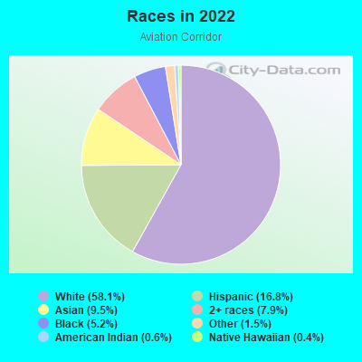
- 39,75258.1%White
- 11,48716.8%Hispanic or Latino
- 6,5279.5%Asian
- 5,4147.9%Two or more races
- 3,5755.2%Black
- 1,0011.5%Some other race
- 4190.6%American Indian
- 2760.4%Native Hawaiian and Other
Pacific Islander
Median household income in 2022:
| Aviation Corridor: | $156,995 |
| El Segundo: | $142,596 |
Distribution of median household income
![Distribution of median household income]()
- 1,081Less than $10,000
- 1,883$10,000 to $19,999
- 1,426$20,000 to $29,999
- 1,760$30,000 to $39,999
- 818$40,000 to $49,999
- 1,484$50,000 to $59,999
- 2,175$60,000 to $74,999
- 2,544$75,000 to $99,999
- 2,172$100,000 to $124,999
- 3,185$125,000 to $149,999
- 4,563$150,000 to $199,999
- 8,689$200,000 or more

Distribution of owner-occupied house/condo value
![Distribution of owner-occupied house/condo value]()
- 1,539Less than $50,000
- 587$50,000 to $99,999
- 413$100,000 to $149,999
- 1,416$150,000 to $199,999
- 892$200,000 to $249,999
- 167$250,000 to $299,999
- 177$300,000 to $399,999
- 705$400,000 to $499,999
- 1,161$500,000 to $749,999
- 1,034$750,000 to $999,999
- 10,754$1,000,000 or more

Distribution of rent paid by renters
![Distribution of rent paid by renters]()
- 1,035Less than $100
- 224$500 to $599
- 862$600 to $699
- 3,078$700 to $799
- 1,014$900 to $999
- 2,311$1,000 to $1,249
- 1,036$1,250 to $1,499
- 3,090$1,500 to $1,999
- 13,287$2,000 or more

| Males: | 33,476 |
| Females: | 32,608 |
Males:
| This neighborhood: | 40.4 years |
| Whole city: | 35.9 years |
| This neighborhood: | 39.5 years |
| Whole city: | 36.8 years |
Average household size:
| Aviation Corridor: | 9.7 people |
| El Segundo: | 2.4 people |
Percentage of family households:
| Aviation Corridor: | 46.0% |
| El Segundo: | 45.9% |
| Here: | 47.5% |
| El Segundo: | 47.5% |
Percentage of married-couple families with children (among all households):
| Aviation Corridor: | 34.8% |
| El Segundo: | 34.4% |
Percentage of single-mother households (among all households):
| Aviation Corridor: | 4.4% |
| El Segundo: | 3.5% |
Percentage of never married males 15 years old and over:
Percentage of never married females 15 years old and over:
| Aviation Corridor: | 18.3% |
| El Segundo: | 18.7% |
Percentage of never married females 15 years old and over:
| Aviation Corridor: | 15.3% |
| city: | 15.5% |
Percentage of people that speak English not well or not at all:
| Aviation Corridor: | 0.7% |
| El Segundo: | 0.8% |
Percentage of people born in this state:
Percentage of people born in another U.S. state:
Percentage of native residents but born outside the U.S.:
Percentage of foreign born residents:
| Here: | 60.6% |
| El Segundo: | 61.8% |
Percentage of people born in another U.S. state:
| Aviation Corridor: | 25.9% |
| El Segundo: | 24.1% |
Percentage of native residents but born outside the U.S.:
| Here: | 2.0% |
| city: | 2.1% |
Percentage of foreign born residents:
| Here: | 11.5% |
| El Segundo: | 12.0% |
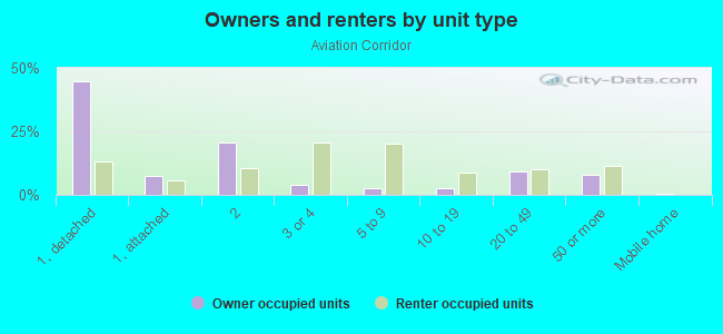
Owner-occupied
Renter-occupied

- Rooms in owner-occupied houses and condos in Aviation Corridor
- 4,1851 room
- 8532 rooms
- 6173 rooms
- 1,6244 rooms
- 1,6175 rooms
- 2,7016 rooms
- 2,7867 rooms
- 2,0298 rooms
- 2,5309+ rooms
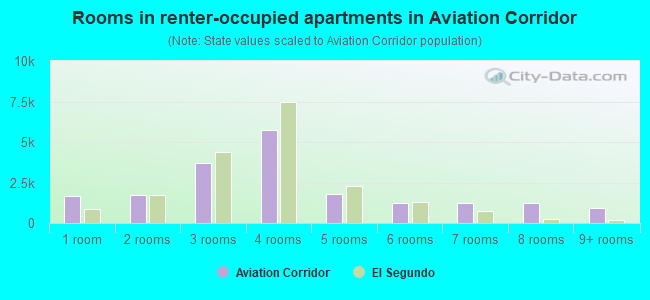
- Rooms in renter-occupied apartments in Aviation Corridor
- 1,6551 room
- 1,7092 rooms
- 3,7203 rooms
- 5,7364 rooms
- 1,8135 rooms
- 1,2556 rooms
- 1,2057 rooms
- 1,2228 rooms
- 8989+ rooms
Owner-occupied
Renter-occupied
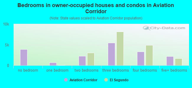
- Bedrooms in owner-occupied houses and condos in Aviation Corridor
- 3,926no bedroom
- 6861 bedroom
- 2,2852 bedrooms
- 5,4523 bedrooms
- 3,3154 bedrooms
- 2,2045+ bedrooms
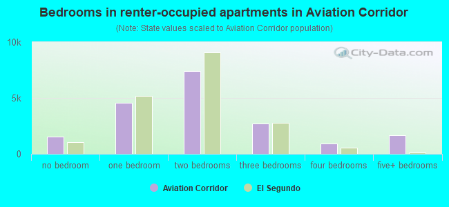
- Bedrooms in renter-occupied apartments in Aviation Corridor
- 1,519no bedroom
- 4,5471 bedroom
- 7,4212 bedrooms
- 2,7403 bedrooms
- 9154 bedrooms
- 1,6405+ bedrooms
Average number of cars or other vehicles available in houses/condos:
Average number of cars or other vehicles available in apartments:
| This neighborhood: | 2.3 |
| El Segundo: | 2.2 |
Average number of cars or other vehicles available in apartments:
| Here: | |
| city: |
Percentage of units with a mortgage:
| Aviation Corridor: | 76.8% |
| El Segundo: | 76.7% |
Average estimated value of detached houses in 2022 (44.6% of all units):
| Aviation Corridor: | $1,950,694 |
| California: | $988,808 |
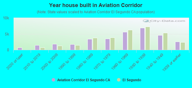
- Year house built in Aviation Corridor
- 7132020 or later
- 1,4552010 to 2019
- 1,8552000 to 2009
- 1,7021990 to 1999
- 3,4141980 to 1989
- 3,5061970 to 1979
- 5,6421960 to 1969
- 6,8541950 to 1959
- 4,6261940 to 1949
- 2,5691939 or earlier
City-data.com crime index for city in 2020 (higher means more crime):
| City: | 451.3 |
| U.S. average: | 219.5 |
Travel time to work (commute)
![Travel time to work (commute)]()
- 591Less than 5 minutes
- 4,1545 to 9 minutes
- 5,95310 to 14 minutes
- 4,11015 to 19 minutes
- 2,69820 to 24 minutes
- 1,50525 to 29 minutes
- 3,60930 to 34 minutes
- 81035 to 39 minutes
- 1,54840 to 44 minutes
- 2,64445 to 59 minutes
- 1,97960 to 89 minutes
- 54490 or more minutes

Means of transportation to work
![Means of transportation to work]()
- 66.7%24,902Drove a car alone
- 3.5%1,324Carpooled
- 2.0%737Bus
- 3.0%1,103Subway or elevated rail
- 3.2%1,178Taxi
- 1.7%643Motorcycle
- 1.8%659Bicycle
- 5.2%1,955Walked
- 1.3%502Other means
- 23.2%8,672Worked at home

Time leaving home to go to work
![Time leaving home to go to work]()
- 1,03112:00 a.m. to 4:59 a.m.
- 1,0355:00 a.m. to 5:29 a.m.
- 1,6115:30 a.m. to 5:59 a.m.
- 2,6876:00 a.m. to 6:29 a.m.
- 2,0136:30 a.m. to 6:59 a.m.
- 3,7787:00 a.m. to 7:29 a.m.
- 3,0217:30 a.m. to 7:59 a.m.
- 5,3898:00 a.m. to 8:29 a.m.
- 3,0598:30 a.m. to 8:59 a.m.
- 3,5409:00 a.m. to 9:59 a.m.
- 1,05210:00 a.m. to 10:59 a.m.
- 40111:00 a.m. to 11:59 a.m.
- 90012:00 p.m. to 3:59 p.m.
- 1,0004:00 p.m. to 11:59 p.m.

Occupations of males:
- Percentage of males in management occupations (except farmers):
Here: 17.6% city: 15.3%
- Percentage of males in business and financial operations occupations:
Here: 8.2% city: 7.4%
- Percentage of males in computer and mathematical occupations:
Here: 6.9% city: 7.2%
- Percentage of males in architecture and engineering occupations:
Here: 10.3% city: 11.5%
- Percentage of males in community and social services occupations:
Here: 3.3% city: 3.6%
- Percentage of males in legal occupations:
Here: 1.8% city: 1.8%
- Percentage of males in education, training, and library occupations:
Here: 2.2% city: 2.5%
- Percentage of males in arts, design, entertainment, sports, and media occupations:
Here: 10.7% city: 9.7%
- Percentage of males in healthcare practitioners and technical occupations:
Here: 3.0% city: 2.6%
- Percentage of males in service occupations:
Here: 8.1% city: 9.3%
- Percentage of males in sales and office occupations:
Here: 13.7% city: 13.2%
- Percentage of males in construction, extraction, and maintenance occupations:
Here: 1.8% city: 2.1%
- Percentage of males in production occupations:
Here: 3.3% city: 3.7%
- Percentage of males in transportation occupations:
Here: 1.8% city: 1.9%
- Percentage of males in material moving occupations:
Here: 1.1% city: 1.2%
Occupations of females:
- Percentage of females in management occupations (except farmers):
Here: 17.2% city: 15.2%
- Percentage of females in business and financial operations occupations:
Here: 12.0% city: 12.3%
- Percentage of females in computer and mathematical occupations:
Here: 3.3% city: 3.6%
- Percentage of females in architecture and engineering occupations:
Here: 2.2% city: 2.3%
- Percentage of females in community and social services occupations:
Here: 3.0% city: 2.9%
- Percentage of females in legal occupations:
Here: 3.2% city: 3.2%
- Percentage of females in education, training, and library occupations:
Here: 7.5% city: 7.7%
- Percentage of females in arts, design, entertainment, sports, and media occupations:
Here: 7.7% city: 7.5%
- Percentage of females in healthcare practitioners and technical occupations:
Here: 9.8% city: 9.6%
- Percentage of females in service occupations:
Here: 10.0% city: 10.8%
- Percentage of females in sales and office occupations:
Here: 21.4% city: 22.0%
Percentage of people 16-64 in Armed Forces:
| Aviation Corridor: | 0.1% |
| El Segundo: | 0.1% |
Education in this neighborhood (subdivision or community):
- Percentage of people 3 years and older in K-12 schools:
Aviation Corridor: 24.8% El Segundo: 17.1%
- Percentage of people 3 years and older in undergraduate colleges:
Aviation Corridor: 4.9% El Segundo: 4.3%
- Percentage of people 3 years and older in grad. or professional schools:
Aviation Corridor: 3.0% El Segundo: 2.4%
- Percentage of students K-12 enrolled in private schools:
Aviation Corridor: 44.0% El Segundo: 6.7%
Percentage of population below poverty level:
| Aviation Corridor: | 4.5% |
| El Segundo: | 4.7% |
Percentage of married-couple families with both working:
| Aviation Corridor: | 82.3% |
| El Segundo: | 75.9% |
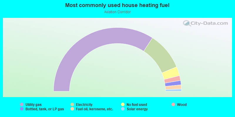
- 68.4%Utility gas
- 19.1%Electricity
- 4.6%No fuel used
- 2.5%Wood
- 2.2%Bottled, tank, or LP gas
- 2.1%Fuel oil, kerosene, etc.
- 1.1%Solar energy
Limited-access highways (interstate or state) in this neighborhood:
Century Fwy (Glenn Anderson Frwy Eastbound Ln, I- 105)
Length: 3.55 miles
Direction: E-W
Direction: E-W
Highways in this neighborhood:
E Imperial Hwy
Length: 2.55 miles
Directions: E-W, SE-NW
Address range: 1400 to 6851
Directions: E-W, SE-NW
Address range: 1400 to 6851
Vis del Mar
Length: 2.01 miles
Directions: E-W, N-S, SE-NW
Address range: 300 to 12799
Directions: E-W, N-S, SE-NW
Address range: 300 to 12799
W Imperial Hwy
Length: 1.45 miles
Direction: E-W
Address range: 5588 to 7799
Direction: E-W
Address range: 5588 to 7799
S Sepulveda Blvd (State Rte 1)
Length: 1.21 miles
Directions: N-S, SW-NE
Address range: 100 to 11998
Directions: N-S, SW-NE
Address range: 100 to 11998
N Sepulveda Blvd (State Rte 1)
Length: 1.11 miles
Direction: N-S
Address range: 100 to 3699
Direction: N-S
Address range: 100 to 3699
N Highland Ave
Length: 0.57 miles
Directions: N-S, SE-NW
Address range: 3300 to 4499
Directions: N-S, SE-NW
Address range: 3300 to 4499
Roads and streets:
E el Segundo Blvd
Length: 2.73 miles
Directions: E-W, N-S
Address range: 100 to 2449
Directions: E-W, N-S
Address range: 100 to 2449
E Mariposa Ave
Length: 2.26 miles
Directions: E-W, SE-NW
Address range: 100 to 2299
Directions: E-W, SE-NW
Address range: 100 to 2299
E Grand Ave
Length: 2.12 miles
Direction: E-W
Address range: 100 to 2299
Direction: E-W
Address range: 100 to 2299
E Maple Ave
Length: 1.96 miles
Direction: E-W
Address range: 100 to 2199
Direction: E-W
Address range: 100 to 2199
Rosecrans Ave (W Rosecrans Ave)
Length: 1.64 miles
Directions: E-W, SW-NE
Address range: 101 to 1899
Directions: E-W, SW-NE
Address range: 101 to 1899
E Walnut Ave
Length: 1.41 miles
Directions: E-W, N-S, SE-NW, SW-NE
Address range: 100 to 1999
Directions: E-W, N-S, SE-NW, SW-NE
Address range: 100 to 1999
35th St
Length: 1.38 miles
Direction: E-W
Address range: 100 to 1099
Direction: E-W
Address range: 100 to 1099
E Imperial Ave
Length: 1.24 miles
Direction: E-W
Address range: 100 to 1799
Direction: E-W
Address range: 100 to 1799
E Franklin Ave
Length: 1.21 miles
Direction: E-W
Address range: 100 to 1699
Direction: E-W
Address range: 100 to 1699
E Pine Ave
Length: 1.19 miles
Direction: E-W
Address range: 100 to 1799
Direction: E-W
Address range: 100 to 1799
N Nash St
Length: 1.04 miles
Direction: N-S
Address range: 100 to 999
Direction: N-S
Address range: 100 to 999
Main St
Length: 1.04 miles
Direction: N-S
Address range: 100 to 997
Direction: N-S
Address range: 100 to 997
E Sycamore Ave
Length: 1.01 miles
Direction: E-W
Address range: 200 to 1899
Direction: E-W
Address range: 200 to 1899
N Douglas St
Length: 1.01 miles
Directions: E-W, N-S
Address range: 100 to 998
Directions: E-W, N-S
Address range: 100 to 998
Virginia St
Length: 1.00 miles
Direction: N-S
Address range: 100 to 999
Direction: N-S
Address range: 100 to 999
Center St
Length: 1.00 miles
Direction: N-S
Address range: 100 to 999
Direction: N-S
Address range: 100 to 999
California St
Length: 0.98 miles
Directions: E-W, N-S, SE-NW, SW-NE
Address range: 200 to 1099
Directions: E-W, N-S, SE-NW, SW-NE
Address range: 200 to 1099
Aviation Blvd
Length: 0.98 miles
Direction: N-S
Address range: 11100 to 13598
Direction: N-S
Address range: 11100 to 13598
Loma Vista St
Length: 0.97 miles
Direction: N-S
Address range: 100 to 999
Direction: N-S
Address range: 100 to 999
Lomita St
Length: 0.92 miles
Directions: N-S, SW-NE
Address range: 100 to 999
Directions: N-S, SW-NE
Address range: 100 to 999
36th Pl
Length: 0.90 miles
Direction: E-W
Address range: 100 to 799
Direction: E-W
Address range: 100 to 799
Eucalyptus Dr
Length: 0.89 miles
Direction: N-S
Address range: 100 to 999
Direction: N-S
Address range: 100 to 999
36th St
Length: 0.88 miles
Direction: E-W
Address range: 100 to 799
Direction: E-W
Address range: 100 to 799
Maryland St
Length: 0.87 miles
Directions: E-W, N-S, SE-NW, SW-NE
Address range: 100 to 999
Directions: E-W, N-S, SE-NW, SW-NE
Address range: 100 to 999
Sheldon St
Length: 0.86 miles
Direction: N-S
Address range: 100 to 999
Direction: N-S
Address range: 100 to 999
E Oak Ave
Length: 0.84 miles
Directions: E-W, N-S
Address range: 100 to 1599
Directions: E-W, N-S
Address range: 100 to 1599
E Palm Ave
Length: 0.84 miles
Direction: E-W
Address range: 500 to 1699
Direction: E-W
Address range: 500 to 1699
E Holly Ave
Length: 0.81 miles
Directions: E-W, SW-NE
Address range: 100 to 1899
Directions: E-W, SW-NE
Address range: 100 to 1899
Bungalow Dr
Length: 0.79 miles
Direction: N-S
Address range: 100 to 1031
Direction: N-S
Address range: 100 to 1031
W Imperial Ave
Length: 0.78 miles
Direction: E-W
Address range: 100 to 799
Direction: E-W
Address range: 100 to 799
Penn St
Length: 0.77 miles
Directions: N-S, SE-NW, SW-NE
Address range: 100 to 899
Directions: N-S, SE-NW, SW-NE
Address range: 100 to 899
W Sycamore Ave
Length: 0.75 miles
Direction: E-W
Address range: 100 to 799
Direction: E-W
Address range: 100 to 799
35th Pl
Length: 0.74 miles
Direction: E-W
Address range: 100 to 799
Direction: E-W
Address range: 100 to 799
33rd Pl
Length: 0.73 miles
Direction: E-W
Address range: 100 to 799
Direction: E-W
Address range: 100 to 799
W Maple Ave
Length: 0.73 miles
Direction: E-W
Address range: 100 to 799
Direction: E-W
Address range: 100 to 799
Hillcrest St
Length: 0.72 miles
Direction: N-S
Address range: 300 to 999
Direction: N-S
Address range: 300 to 999
E Acacia Ave
Length: 0.70 miles
Directions: E-W, SE-NW
Address range: 200 to 1299
Directions: E-W, SE-NW
Address range: 200 to 1299
W Palm Ave
Length: 0.70 miles
Direction: E-W
Address range: 100 to 799
Direction: E-W
Address range: 100 to 799
S Douglas St
Length: 0.69 miles
Directions: N-S, SW-NE
Address range: 100 to 699
Directions: N-S, SW-NE
Address range: 100 to 699
Sierra St
Length: 0.69 miles
Directions: N-S, SW-NE
Address range: 100 to 799
Directions: N-S, SW-NE
Address range: 100 to 799
W Acacia Ave
Length: 0.68 miles
Direction: E-W
Address range: 200 to 799
Direction: E-W
Address range: 200 to 799
W Mariposa Ave
Length: 0.68 miles
Direction: E-W
Address range: 100 to 799
Direction: E-W
Address range: 100 to 799
Washington St
Length: 0.66 miles
Direction: N-S
Address range: 100 to 899
Direction: N-S
Address range: 100 to 899
W Pine Ave
Length: 0.65 miles
Direction: E-W
Address range: 100 to 799
Direction: E-W
Address range: 100 to 799
W Oak Ave
Length: 0.65 miles
Direction: E-W
Address range: 100 to 799
Direction: E-W
Address range: 100 to 799
W Walnut Ave
Length: 0.63 miles
Direction: E-W
Address range: 100 to 699
Direction: E-W
Address range: 100 to 699
Richmond St
Length: 0.60 miles
Direction: N-S
Address range: 100 to 699
Direction: N-S
Address range: 100 to 699
Whiting St
Length: 0.60 miles
Direction: N-S
Address range: 100 to 699
Direction: N-S
Address range: 100 to 699
Ocean Dr
Length: 0.57 miles
Directions: N-S, SE-NW
Address range: 3274 to 4499
Directions: N-S, SE-NW
Address range: 3274 to 4499
The Strand (N The Strand)
Length: 0.56 miles
Directions: N-S, SE-NW
Address range: 3300 to 4499
Directions: N-S, SE-NW
Address range: 3300 to 4499
Continental Blvd
Length: 0.55 miles
Directions: N-S, SE-NW
Address range: 100 to 599
Directions: N-S, SE-NW
Address range: 100 to 599
N Crest Dr (Crest Dr)
Length: 0.53 miles
Directions: N-S, SE-NW
Address range: 3300 to 4499
Directions: N-S, SE-NW
Address range: 3300 to 4499
Standard St
Length: 0.50 miles
Direction: N-S
Address range: 100 to 599
Direction: N-S
Address range: 100 to 599
Concord St
Length: 0.50 miles
Direction: N-S
Address range: 100 to 599
Direction: N-S
Address range: 100 to 599
Kansas St
Length: 0.50 miles
Direction: N-S
Address range: 100 to 599
Direction: N-S
Address range: 100 to 599
W Holly Ave
Length: 0.47 miles
Direction: E-W
Address range: 100 to 699
Direction: E-W
Address range: 100 to 699
W el Segundo Blvd
Length: 0.44 miles
Directions: E-W, SE-NW
Address range: 300 to 499
Directions: E-W, SE-NW
Address range: 300 to 499
W Grand Ave
Length: 0.43 miles
Direction: E-W
Address range: 100 to 699
Direction: E-W
Address range: 100 to 699
W Franklin Ave
Length: 0.43 miles
Direction: E-W
Address range: 100 to 699
Direction: E-W
Address range: 100 to 699
S Hughes Way
Length: 0.43 miles
Directions: E-W, SW-NE
Address range: 1900 to 2099
Directions: E-W, SW-NE
Address range: 1900 to 2099
Grand Ave
Length: 0.41 miles
Directions: E-W, SW-NE
Address range: 7400 to 7599
Directions: E-W, SW-NE
Address range: 7400 to 7599
Illinois St
Length: 0.39 miles
Direction: N-S
Address range: 100 to 599
Direction: N-S
Address range: 100 to 599
Oregon St
Length: 0.38 miles
Direction: N-S
Address range: 100 to 599
Direction: N-S
Address range: 100 to 599
Coral Cir
Length: 0.37 miles
Directions: E-W, N-S
Address range: 200 to 499
Directions: E-W, N-S
Address range: 200 to 499
Arena St
Length: 0.37 miles
Direction: N-S
Address range: 100 to 699
Direction: N-S
Address range: 100 to 699
34th St
Length: 0.35 miles
Direction: E-W
Address range: 100 to 499
Direction: E-W
Address range: 100 to 499
33rd St
Length: 0.35 miles
Direction: E-W
Address range: 100 to 499
Direction: E-W
Address range: 100 to 499
Nevada St
Length: 0.34 miles
Direction: N-S
Address range: 100 to 599
Direction: N-S
Address range: 100 to 599
S Aviation Blvd
Length: 0.31 miles
Direction: N-S
Address range: 102 to 407
Direction: N-S
Address range: 102 to 407
Hornet Way
Length: 0.31 miles
Direction: N-S
Address range: 1 to 999
Direction: N-S
Address range: 1 to 999
Atwood Way
Length: 0.31 miles
Direction: E-W
Direction: E-W
Indiana St
Length: 0.29 miles
Direction: N-S
Address range: 300 to 599
Direction: N-S
Address range: 300 to 599
N Aviation Blvd
Length: 0.27 miles
Direction: N-S
Address range: 100 to 499
Direction: N-S
Address range: 100 to 499
Pepper St
Length: 0.27 miles
Direction: N-S
Address range: 800 to 999
Direction: N-S
Address range: 800 to 999
Duley Rd
Length: 0.27 miles
Direction: N-S
Address range: 100 to 599
Direction: N-S
Address range: 100 to 599
McCarthy Ct
Length: 0.23 miles
Directions: E-W, N-S, SE-NW, SW-NE
Address range: 800 to 999
Directions: E-W, N-S, SE-NW, SW-NE
Address range: 800 to 999
Lairport St
Length: 0.23 miles
Direction: N-S
Address range: 600 to 799
Direction: N-S
Address range: 600 to 799
34th Pl
Length: 0.22 miles
Direction: E-W
Address range: 100 to 499
Direction: E-W
Address range: 100 to 499
E Elm Ave
Length: 0.21 miles
Direction: E-W
Address range: 1400 to 1599
Direction: E-W
Address range: 1400 to 1599
N Alma Ave
Length: 0.19 miles
Directions: N-S, SE-NW
Address range: 3223 to 3699
Directions: N-S, SE-NW
Address range: 3223 to 3699
N Vista Dr
Length: 0.19 miles
Direction: SE-NW
Address range: 3254 to 3699
Direction: SE-NW
Address range: 3254 to 3699
N Manhattan Ave
Length: 0.19 miles
Direction: SE-NW
Address range: 3300 to 3699
Direction: SE-NW
Address range: 3300 to 3699
N Bay View Dr (Bayview Dr)
Length: 0.19 miles
Directions: N-S, SE-NW
Address range: 3300 to 3699
Directions: N-S, SE-NW
Address range: 3300 to 3699
38th St
Length: 0.17 miles
Direction: E-W
Address range: 100 to 399
Direction: E-W
Address range: 100 to 399
39th St
Length: 0.17 miles
Direction: E-W
Address range: 100 to 399
Direction: E-W
Address range: 100 to 399
Bell Ave
Length: 0.17 miles
Directions: N-S, SE-NW
Address range: 3311 to 3699
Directions: N-S, SE-NW
Address range: 3311 to 3699
45th St
Length: 0.17 miles
Direction: E-W
Address range: 1 to 399
Direction: E-W
Address range: 1 to 399
44th St
Length: 0.17 miles
Direction: E-W
Address range: 100 to 399
Direction: E-W
Address range: 100 to 399
43rd St
Length: 0.17 miles
Direction: E-W
Address range: 100 to 399
Direction: E-W
Address range: 100 to 399
42nd St
Length: 0.17 miles
Direction: E-W
Address range: 100 to 399
Direction: E-W
Address range: 100 to 399
41st St
Length: 0.17 miles
Direction: E-W
Address range: 100 to 399
Direction: E-W
Address range: 100 to 399
40th St
Length: 0.17 miles
Direction: E-W
Address range: 100 to 399
Direction: E-W
Address range: 100 to 399
Laurel Ave
Length: 0.17 miles
Direction: N-S
Address range: 3384 to 3699
Direction: N-S
Address range: 3384 to 3699
Elm Ave
Length: 0.17 miles
Direction: N-S
Address range: 3392 to 3699
Direction: N-S
Address range: 3392 to 3699
Flournoy Rd
Length: 0.16 miles
Direction: N-S
Address range: 3400 to 3699
Direction: N-S
Address range: 3400 to 3699
Blanche Rd
Length: 0.16 miles
Direction: N-S
Address range: 3400 to 3699
Direction: N-S
Address range: 3400 to 3699
Binder Pl
Length: 0.14 miles
Directions: E-W, N-S
Address range: 500 to 599
Directions: E-W, N-S
Address range: 500 to 599
38th Pl
Length: 0.14 miles
Direction: E-W
Address range: 100 to 399
Direction: E-W
Address range: 100 to 399
Gull St
Length: 0.14 miles
Direction: E-W
Address range: 100 to 399
Direction: E-W
Address range: 100 to 399
Shell St
Length: 0.14 miles
Direction: E-W
Address range: 100 to 399
Direction: E-W
Address range: 100 to 399
Seaview St
Length: 0.14 miles
Direction: E-W
Address range: 100 to 399
Direction: E-W
Address range: 100 to 399
Moonstone St
Length: 0.14 miles
Direction: E-W
Address range: 100 to 399
Direction: E-W
Address range: 100 to 399
Kelp St
Length: 0.14 miles
Direction: E-W
Address range: 100 to 399
Direction: E-W
Address range: 100 to 399
el Porto St
Length: 0.14 miles
Direction: E-W
Address range: 100 to 399
Direction: E-W
Address range: 100 to 399
Grandview Ave
Length: 0.14 miles
Directions: N-S, SE-NW
Address range: 2600 to 3699
Directions: N-S, SE-NW
Address range: 2600 to 3699
Cedar St
Length: 0.13 miles
Direction: N-S
Address range: 900 to 999
Direction: N-S
Address range: 900 to 999
N Poinsettia Ave
Length: 0.13 miles
Direction: N-S
Address range: 3500 to 3699
Direction: N-S
Address range: 3500 to 3699
Palm Ave
Length: 0.13 miles
Direction: N-S
Address range: 3500 to 3699
Direction: N-S
Address range: 3500 to 3699
Walnut Ave
Length: 0.13 miles
Direction: N-S
Address range: 3500 to 3699
Direction: N-S
Address range: 3500 to 3699
Cypress St
Length: 0.13 miles
Direction: N-S
Address range: 900 to 999
Direction: N-S
Address range: 900 to 999
Pine Ave
Length: 0.13 miles
Direction: N-S
Address range: 3500 to 3699
Direction: N-S
Address range: 3500 to 3699
Maple Ave
Length: 0.13 miles
Direction: N-S
Address range: 3500 to 3699
Direction: N-S
Address range: 3500 to 3699
Pacific Ave
Length: 0.13 miles
Direction: N-S
Address range: 3500 to 3699
Direction: N-S
Address range: 3500 to 3699
Bayonne St
Length: 0.13 miles
Direction: N-S
Address range: 700 to 799
Direction: N-S
Address range: 700 to 799
Dune St
Length: 0.13 miles
Direction: N-S
Address range: 800 to 999
Direction: N-S
Address range: 800 to 999
Oak Ave
Length: 0.13 miles
Directions: N-S, SE-NW
Address range: 3500 to 3699
Directions: N-S, SE-NW
Address range: 3500 to 3699
Valley St
Length: 0.13 miles
Direction: N-S
Address range: 300 to 499
Direction: N-S
Address range: 300 to 499
Selby St
Length: 0.13 miles
Direction: N-S
Address range: 900 to 997
Direction: N-S
Address range: 900 to 997
N Valley Dr
Length: 0.11 miles
Directions: E-W, SW-NE
Address range: 3374 to 3599
Directions: E-W, SW-NE
Address range: 3374 to 3599
Rosecrans Pl
Length: 0.11 miles
Direction: E-W
Address range: 100 to 399
Direction: E-W
Address range: 100 to 399
Redwood Ave
Length: 0.10 miles
Directions: E-W, N-S
Address range: 700 to 799
Directions: E-W, N-S
Address range: 700 to 799
Judah Ave
Length: 0.10 miles
Direction: N-S
Address range: 12100 to 13399
Direction: N-S
Address range: 12100 to 13399
S Allied Way
Length: 0.09 miles
Direction: N-S
Address range: 600 to 699
Direction: N-S
Address range: 600 to 699
Continental City Drive Way
Length: 0.08 miles
Directions: E-W, SW-NE
Directions: E-W, SW-NE
W 122nd St
Length: 0.08 miles
Direction: E-W
Address range: 5528 to 5599
Direction: E-W
Address range: 5528 to 5599
Indiana Ct
Length: 0.08 miles
Direction: N-S
Address range: 700 to 799
Direction: N-S
Address range: 700 to 799
W Elm Ave
Length: 0.07 miles
Direction: E-W
Address range: 600 to 699
Direction: E-W
Address range: 600 to 699
Concord Pl
Length: 0.07 miles
Direction: N-S
Address range: 800 to 899
Direction: N-S
Address range: 800 to 899
Irene Ct
Length: 0.07 miles
Direction: E-W
Address range: 500 to 599
Direction: E-W
Address range: 500 to 599
W 118th St
Length: 0.06 miles
Direction: E-W
Address range: 5552 to 5599
Direction: E-W
Address range: 5552 to 5599
E Elsey Pl
Length: 0.06 miles
Direction: E-W
Address range: 1000 to 1099
Direction: E-W
Address range: 1000 to 1099
120th St
Length: 0.06 miles
Direction: E-W
Direction: E-W
118th St
Length: 0.06 miles
Direction: E-W
Direction: E-W
Illinois Ct
Length: 0.05 miles
Direction: N-S
Address range: 600 to 699
Direction: N-S
Address range: 600 to 699
Alaska Ave
Length: 0.04 miles
Direction: E-W
Address range: 2300 to 2314
Direction: E-W
Address range: 2300 to 2314
Sierra Pl
Length: 0.03 miles
Direction: SW-NE
Address range: 500 to 599
Direction: SW-NE
Address range: 500 to 599
Agnes Rd
Length: 0.03 miles
Direction: N-S
Address range: 3400 to 3499
Direction: N-S
Address range: 3400 to 3499
Yucca St
Length: 0.03 miles
Direction: N-S
Address range: 700 to 799
Direction: N-S
Address range: 700 to 799
Guaymas Way
Length: 0.03 miles
Direction: N-S
Address range: 442 to 499
Direction: N-S
Address range: 442 to 499
Imperial Hwy
Length: 0.03 miles
Direction: E-W
Direction: E-W
Railroad features:
at and Sf Rlwy
Length: 2.41 miles
Directions: E-W, N-S, SE-NW, SW-NE
Directions: E-W, N-S, SE-NW, SW-NE
Southern Pacific RR
Length: 0.56 miles
Directions: E-W, SW-NE
Directions: E-W, SW-NE