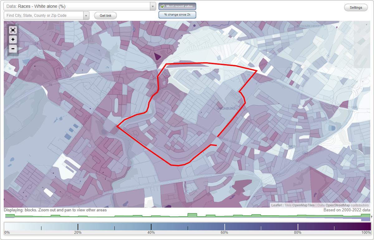
Battle Hill (Battlehill) neighborhood in Union, New Jersey (NJ), 07083 detailed profile
Settings
X

Business Search - 14 Million verified businesses
Area: 1.726 square miles
Population: 10,147
Population density:
| Battle Hill (Battlehill): | 5,880 people per square mile |
| Union: | 5,968 people per square mile |

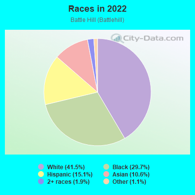
- 4,29941.5%White
- 3,07829.7%Black
- 1,55815.1%Hispanic or Latino
- 1,10210.6%Asian
- 1981.9%Two or more races
- 1101.1%Some other race
- 40.04%American Indian
Median household income in 2022:
| Battle Hill (Battlehill): | $117,485 |
| New Jersey: | $96,346 |
Distribution of median household income
![Distribution of median household income]()
- 211Less than $10,000
- 187$10,000 to $19,999
- 211$20,000 to $29,999
- 258$30,000 to $39,999
- 312$40,000 to $49,999
- 243$50,000 to $59,999
- 337$60,000 to $74,999
- 280$75,000 to $99,999
- 625$100,000 to $124,999
- 255$125,000 to $149,999
- 515$150,000 to $199,999
- 523$200,000 or more

Distribution of owner-occupied house/condo value
![Distribution of owner-occupied house/condo value]()
- 266Less than $50,000
- 65$100,000 to $149,999
- 109$150,000 to $199,999
- 261$200,000 to $249,999
- 247$250,000 to $299,999
- 811$300,000 to $399,999
- 951$400,000 to $499,999
- 577$500,000 to $749,999
- 196$750,000 to $999,999
- 11$1,000,000 or more

Distribution of rent paid by renters
![Distribution of rent paid by renters]()
- 347Less than $100
- 78$200 to $299
- 40$300 to $399
- 92$400 to $499
- 72$800 to $899
- 32$900 to $999
- 84$1,000 to $1,249
- 156$1,250 to $1,499
- 366$1,500 to $1,999
- 576$2,000 or more

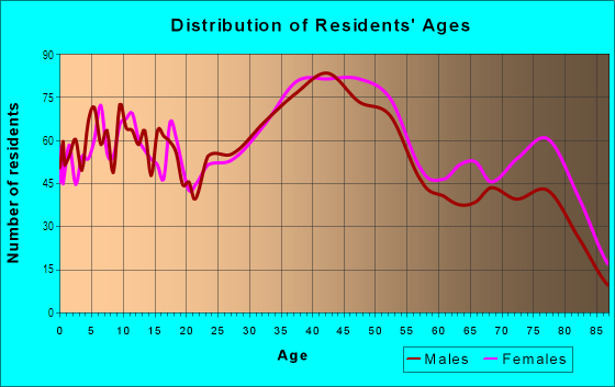
| Males: | 4,448 |
| Females: | 5,698 |
| Males: | 44.4 years |
| Females: | 44.9 years |
Average household size:
| Battle Hill (Battlehill): | 3.0 people |
| New Jersey: | 2.6 people |
Percentage of family households:
| Battle Hill (Battlehill): | 46.4% |
| New Jersey: | 47.0% |
| Here: | 61.3% |
| New Jersey: | 49.9% |
Percentage of married-couple families with children (among all households):
| Battle Hill (Battlehill): | 31.3% |
| New Jersey: | 51.5% |
Percentage of single-mother households (among all households):
| Battle Hill (Battlehill): | 5.0% |
| New Jersey: | 7.6% |
Percentage of never married males 15 years old and over:
Percentage of never married females 15 years old and over:
| Battle Hill (Battlehill): | 13.4% |
| New Jersey: | 18.2% |
Percentage of never married females 15 years old and over:
| Battle Hill (Battlehill): | 18.6% |
| New Jersey: | 16.6% |
Percentage of people that speak English not well or not at all:
| Battle Hill (Battlehill): | 7.0% |
| New Jersey: | 6.5% |
Percentage of people born in this state:
Percentage of people born in another U.S. state:
Percentage of native residents but born outside the U.S.:
Percentage of foreign born residents:
| Here: | 46.2% |
| New Jersey: | 50.7% |
Percentage of people born in another U.S. state:
| Battle Hill (Battlehill): | 10.7% |
| New Jersey: | 23.4% |
Percentage of native residents but born outside the U.S.:
| Here: | 2.1% |
| New Jersey: | 2.4% |
Percentage of foreign born residents:
| Here: | 41.0% |
| New Jersey: | 23.5% |
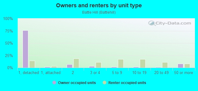
Owner-occupied
Renter-occupied

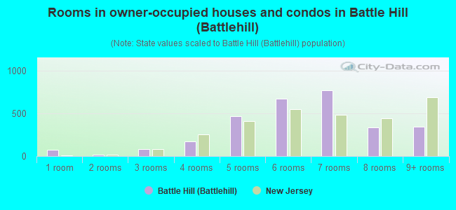
- Rooms in owner-occupied houses and condos in Battle Hill <
> - 741 room
- 142 rooms
- 813 rooms
- 1704 rooms
- 4685 rooms
- 6766 rooms
- 7737 rooms
- 3408 rooms
- 3449+ rooms
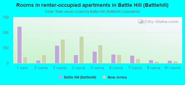
- Rooms in renter-occupied apartments in Battle Hill <
> - 6041 room
- 492 rooms
- 2913 rooms
- 1394 rooms
- 1965 rooms
- 1506 rooms
- 1297 rooms
- 578 rooms
- 449+ rooms
Owner-occupied
Renter-occupied
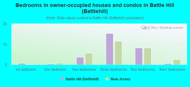
- Bedrooms in owner-occupied houses and condos in Battle Hill <
> - 74no bedroom
- 441 bedroom
- 3642 bedrooms
- 1,5333 bedrooms
- 8194 bedrooms
- 605+ bedrooms
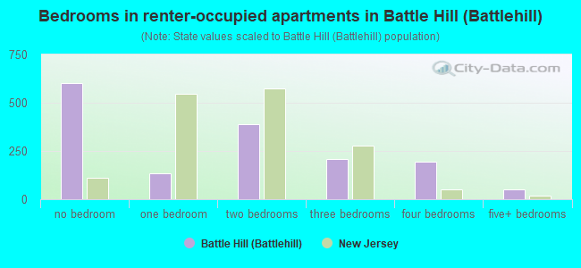
- Bedrooms in renter-occupied apartments in Battle Hill <
> - 604no bedroom
- 1351 bedroom
- 3872 bedrooms
- 2093 bedrooms
- 1954 bedrooms
- 525+ bedrooms
Average number of cars or other vehicles available in houses/condos:
Average number of cars or other vehicles available in apartments:
| This neighborhood: | 2.2 |
| New Jersey: | 2.0 |
Average number of cars or other vehicles available in apartments:
| Here: | 1.4 |
| New Jersey: | 1.1 |
Percentage of units with a mortgage:
| Battle Hill (Battlehill): | 68.4% |
| New Jersey: | 63.3% |
Average estimated value of detached houses in 2022 (74.9% of all units):
| Battle Hill (Battlehill): | $394,321 |
| New Jersey: | $537,591 |
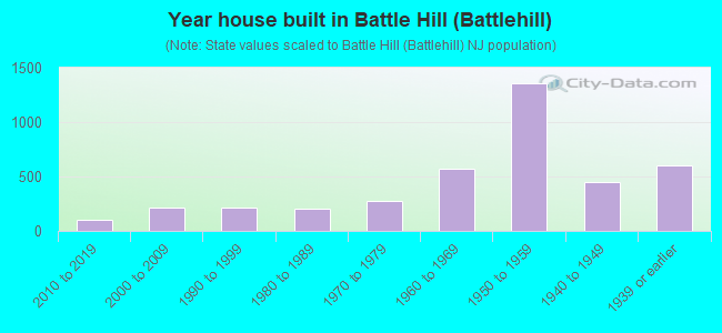
- Year house built in Battle Hill <
> - 02020 or later
- 1042010 to 2019
- 2142000 to 2009
- 2191990 to 1999
- 2001980 to 1989
- 2771970 to 1979
- 5761960 to 1969
- 1,3541950 to 1959
- 4491940 to 1949
- 5981939 or earlier
City-data.com crime index for place in 2020 (higher means more crime):
| City: | 80.9 |
| U.S. average: | 219.5 |
Travel time to work (commute)
![Travel time to work (commute)]()
- 52Less than 5 minutes
- 3835 to 9 minutes
- 60710 to 14 minutes
- 81015 to 19 minutes
- 82820 to 24 minutes
- 57725 to 29 minutes
- 77030 to 34 minutes
- 34335 to 39 minutes
- 27540 to 44 minutes
- 25545 to 59 minutes
- 42960 to 89 minutes
- 27890 or more minutes

Means of transportation to work
![Means of transportation to work]()
- 70.8%3,747Drove a car alone
- 8.9%469Carpooled
- 2.7%142Bus
- 3.0%158Subway or elevated rail
- 1.6%84Long-distance train or commuter rail
- 2.3%123Light rail, streetcar or trolley
- 4.4%232Taxi
- 1.3%68Bicycle
- 2.2%117Walked
- 2.7%143Other means
- 10.1%532Worked at home

Time leaving home to go to work
![Time leaving home to go to work]()
- 22912:00 a.m. to 4:59 a.m.
- 1505:00 a.m. to 5:29 a.m.
- 5545:30 a.m. to 5:59 a.m.
- 4786:00 a.m. to 6:29 a.m.
- 4386:30 a.m. to 6:59 a.m.
- 6487:00 a.m. to 7:29 a.m.
- 7297:30 a.m. to 7:59 a.m.
- 8298:00 a.m. to 8:29 a.m.
- 4288:30 a.m. to 8:59 a.m.
- 2539:00 a.m. to 9:59 a.m.
- 23610:00 a.m. to 10:59 a.m.
- 19611:00 a.m. to 11:59 a.m.
- 25612:00 p.m. to 3:59 p.m.
- 1744:00 p.m. to 11:59 p.m.

Occupations of males:
- Percentage of males in management occupations (except farmers):
Here: 4.5% New Jersey: 13.9%
- Percentage of males in business and financial operations occupations:
Here: 4.5% New Jersey: 6.9%
- Percentage of males in computer and mathematical occupations:
Here: 10.5% New Jersey: 6.5%
- Percentage of males in architecture and engineering occupations:
Here: 3.9% New Jersey: 3.1%
- Percentage of males in life, physical, and social science occupations:
Here: 1.7% New Jersey: 1.2%
- Percentage of males in legal occupations:
Here: 1.1% New Jersey: 1.5%
- Percentage of males in arts, design, entertainment, sports, and media occupations:
Here: 2.9% New Jersey: 2.0%
- Percentage of males in healthcare practitioners and technical occupations:
Here: 5.3% New Jersey: 3.2%
- Percentage of males in service occupations:
Here: 9.5% New Jersey: 12.9%
- Percentage of males in sales and office occupations:
Here: 18.9% New Jersey: 15.3%
- Percentage of males in construction, extraction, and maintenance occupations:
Here: 9.1% New Jersey: 8.1%
- Percentage of males in production occupations:
Here: 3.7% New Jersey: 4.8%
- Percentage of males in transportation occupations:
Here: 11.9% New Jersey: 6.5%
- Percentage of males in material moving occupations:
Here: 6.5% New Jersey: 4.7%
Occupations of females:
- Percentage of females in management occupations (except farmers):
Here: 6.5% New Jersey: 10.4%
- Percentage of females in business and financial operations occupations:
Here: 5.7% New Jersey: 7.3%
- Percentage of females in computer and mathematical occupations:
Here: 5.1% New Jersey: 2.4%
- Percentage of females in legal occupations:
Here: 1.6% New Jersey: 1.6%
- Percentage of females in education, training, and library occupations:
Here: 14.5% New Jersey: 11.4%
- Percentage of females in healthcare practitioners and technical occupations:
Here: 20.0% New Jersey: 9.6%
- Percentage of females in service occupations:
Here: 14.5% New Jersey: 17.2%
- Percentage of females in sales and office occupations:
Here: 25.2% New Jersey: 26.7%
- Percentage of females in production occupations:
Here: 1.4% New Jersey: 2.7%
- Percentage of females in transportation occupations:
Here: 3.7% New Jersey: 1.2%
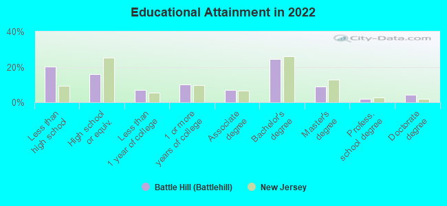
Education in this neighborhood (subdivision or community):
- Percentage of people 3 years and older in K-12 schools:
Battle Hill (Battlehill): 18.7% New Jersey: 16.6%
- Percentage of people 3 years and older in undergraduate colleges:
Battle Hill (Battlehill): 9.4% New Jersey: 4.9%
- Percentage of people 3 years and older in grad. or professional schools:
Battle Hill (Battlehill): 1.5% New Jersey: 1.6%
- Percentage of students K-12 enrolled in private schools:
Battle Hill (Battlehill): 25.0% New Jersey: 12.7%
Percentage of population below poverty level:
| Battle Hill (Battlehill): | 5.4% |
| New Jersey: | 9.7% |
Median year owner moved in (as recorded in 2022):
Median year renter moved in (as recorded in 2022):
| Battle Hill (Battlehill): | 2003 |
| New Jersey: | 2008 |
Median year renter moved in (as recorded in 2022):
| Battle Hill (Battlehill): | 2013 |
| New Jersey: | 2019 |
Percentage of married-couple families with both working:
| Battle Hill (Battlehill): | 79.6% |
| New Jersey: | 72.0% |
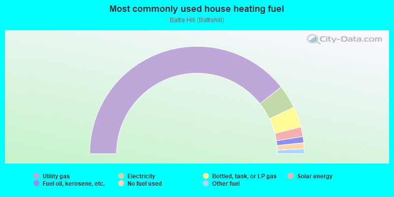
- 78.6%Utility gas
- 7.1%Electricity
- 6.2%Bottled, tank, or LP gas
- 2.9%Solar energy
- 1.9%Fuel oil, kerosene, etc.
- 1.8%No fuel used
- 1.4%Other fuel
Limited-access highways (interstate or state) in this neighborhood:
I- 78
Length: 1.55 miles
Direction: E-W
Direction: E-W
Highways in this neighborhood:
State Rte 82 (Morris Ave)
Length: 1.28 miles
Directions: E-W, SE-NW
Address range: 2300 to 2822
Directions: E-W, SE-NW
Address range: 2300 to 2822
State Rte 124 (Springfield Ave)
Length: 0.23 miles
Direction: SW-NE
Direction: SW-NE
Roads and streets:
Liberty Ave
Length: 1.90 miles
Directions: E-W, SW-NE
Address range: 600 to 1499
Directions: E-W, SW-NE
Address range: 600 to 1499
Rahway Ave
Length: 1.34 miles
Directions: E-W, SE-NW, SW-NE
Address range: 500 to 999
Directions: E-W, SE-NW, SW-NE
Address range: 500 to 999
Burnet Ave
Length: 1.32 miles
Directions: E-W, N-S, SW-NE
Address range: 1000 to 1640
Directions: E-W, N-S, SW-NE
Address range: 1000 to 1640
Spruce St
Length: 0.98 miles
Directions: E-W, N-S, SE-NW
Address range: 2500 to 2899
Directions: E-W, N-S, SE-NW
Address range: 2500 to 2899
Audrey Ter
Length: 0.92 miles
Directions: E-W, N-S, SE-NW, SW-NE
Address range: 2477 to 2843
Directions: E-W, N-S, SE-NW, SW-NE
Address range: 2477 to 2843
Allen Ave
Length: 0.82 miles
Directions: E-W, SE-NW, SW-NE
Address range: 2500 to 2868
Directions: E-W, SE-NW, SW-NE
Address range: 2500 to 2868
Garden St
Length: 0.76 miles
Directions: E-W, SE-NW, SW-NE
Address range: 600 to 967
Directions: E-W, SE-NW, SW-NE
Address range: 600 to 967
Vaux Hall Rd
Length: 0.73 miles
Directions: N-S, SE-NW
Address range: 2239 to 2629
Directions: N-S, SE-NW
Address range: 2239 to 2629
Pinewood Rd
Length: 0.65 miles
Directions: E-W, SW-NE
Address range: 658 to 881
Directions: E-W, SW-NE
Address range: 658 to 881
Killian Pl
Length: 0.49 miles
Direction: SE-NW
Address range: 2614 to 2799
Direction: SE-NW
Address range: 2614 to 2799
Stahuber Ave
Length: 0.48 miles
Directions: N-S, SE-NW, SW-NE
Directions: N-S, SE-NW, SW-NE
Lousons Rd
Length: 0.43 miles
Directions: E-W, N-S, SE-NW, SW-NE
Address range: 1050 to 1123
Directions: E-W, N-S, SE-NW, SW-NE
Address range: 1050 to 1123
Schneider Ave
Length: 0.39 miles
Direction: SW-NE
Address range: 990 to 1158
Direction: SW-NE
Address range: 990 to 1158
Ridgeway St
Length: 0.39 miles
Direction: SW-NE
Address range: 1413 to 1599
Direction: SW-NE
Address range: 1413 to 1599
Hawthorne Ave
Length: 0.38 miles
Directions: E-W, N-S, SE-NW, SW-NE
Address range: 2500 to 2699
Directions: E-W, N-S, SE-NW, SW-NE
Address range: 2500 to 2699
Hickory Rd
Length: 0.38 miles
Directions: N-S, SE-NW
Address range: 100 to 2799
Directions: N-S, SE-NW
Address range: 100 to 2799
Woodside Rd
Length: 0.37 miles
Direction: SE-NW
Address range: 2400 to 2531
Direction: SE-NW
Address range: 2400 to 2531
Mitchell Ave
Length: 0.37 miles
Directions: E-W, SW-NE
Address range: 734 to 870
Directions: E-W, SW-NE
Address range: 734 to 870
Gruber Ave
Length: 0.36 miles
Directions: E-W, SW-NE
Address range: 1066 to 1299
Directions: E-W, SW-NE
Address range: 1066 to 1299
Carol Rd
Length: 0.36 miles
Directions: E-W, SE-NW
Address range: 2700 to 2828
Directions: E-W, SE-NW
Address range: 2700 to 2828
Inwood Rd
Length: 0.35 miles
Directions: N-S, SW-NE
Address range: 700 to 899
Directions: N-S, SW-NE
Address range: 700 to 899
Hemlock Rd
Length: 0.35 miles
Directions: E-W, SW-NE
Address range: 720 to 843
Directions: E-W, SW-NE
Address range: 720 to 843
Meister Ave
Length: 0.34 miles
Direction: SE-NW
Address range: 2600 to 2799
Direction: SE-NW
Address range: 2600 to 2799
Doris Ave
Length: 0.34 miles
Direction: SE-NW
Address range: 2500 to 2614
Direction: SE-NW
Address range: 2500 to 2614
Debra Way
Length: 0.33 miles
Directions: E-W, SW-NE
Address range: 2801 to 2864
Directions: E-W, SW-NE
Address range: 2801 to 2864
Sheridan St
Length: 0.31 miles
Directions: N-S, SW-NE
Address range: 818 to 941
Directions: N-S, SW-NE
Address range: 818 to 941
Ray Ave
Length: 0.31 miles
Direction: SW-NE
Address range: 840 to 965
Direction: SW-NE
Address range: 840 to 965
Carlton Ter
Length: 0.31 miles
Directions: N-S, SE-NW, SW-NE
Address range: 1100 to 1299
Directions: N-S, SE-NW, SW-NE
Address range: 1100 to 1299
Andover Rd
Length: 0.30 miles
Directions: E-W, SE-NW, SW-NE
Address range: 720 to 821
Directions: E-W, SE-NW, SW-NE
Address range: 720 to 821
Larchmont Rd
Length: 0.30 miles
Directions: N-S, SE-NW, SW-NE
Address range: 1001 to 2806
Directions: N-S, SE-NW, SW-NE
Address range: 1001 to 2806
Kathleen Ter
Length: 0.30 miles
Directions: E-W, SE-NW, SW-NE
Address range: 2772 to 2867
Directions: E-W, SE-NW, SW-NE
Address range: 2772 to 2867
Locust Dr
Length: 0.30 miles
Directions: E-W, SE-NW, SW-NE
Address range: 91 to 199
Directions: E-W, SE-NW, SW-NE
Address range: 91 to 199
Burns Pl
Length: 0.29 miles
Direction: SE-NW
Address range: 2551 to 2699
Direction: SE-NW
Address range: 2551 to 2699
Terrill Rd
Length: 0.29 miles
Directions: E-W, SE-NW, SW-NE
Address range: 785 to 2499
Directions: E-W, SE-NW, SW-NE
Address range: 785 to 2499
Poplar St
Length: 0.28 miles
Direction: SE-NW
Address range: 2400 to 2599
Direction: SE-NW
Address range: 2400 to 2599
Reid St
Length: 0.28 miles
Directions: E-W, SE-NW
Address range: 2500 to 2649
Directions: E-W, SE-NW
Address range: 2500 to 2649
Jackson Ave
Length: 0.28 miles
Direction: SE-NW
Address range: 117 to 2584
Direction: SE-NW
Address range: 117 to 2584
Hendricks Dr
Length: 0.28 miles
Direction: SW-NE
Direction: SW-NE
N 3rd St
Length: 0.28 miles
Direction: SE-NW
Address range: 2350 to 2485
Direction: SE-NW
Address range: 2350 to 2485
Dorchester Rd
Length: 0.26 miles
Direction: SE-NW
Address range: 2400 to 2499
Direction: SE-NW
Address range: 2400 to 2499
Dayton Ave
Length: 0.26 miles
Direction: SE-NW
Address range: 2400 to 2499
Direction: SE-NW
Address range: 2400 to 2499
Seymour Ave
Length: 0.26 miles
Direction: SE-NW
Address range: 2387 to 2499
Direction: SE-NW
Address range: 2387 to 2499
Cypress Dr
Length: 0.26 miles
Directions: SE-NW, SW-NE
Address range: 1100 to 1118
Directions: SE-NW, SW-NE
Address range: 1100 to 1118
Ridge Dr
Length: 0.26 miles
Direction: SE-NW
Direction: SE-NW
Alice Ter
Length: 0.25 miles
Direction: SE-NW
Address range: 2700 to 2784
Direction: SE-NW
Address range: 2700 to 2784
Bancroft Ave
Length: 0.25 miles
Direction: SE-NW
Address range: 2654 to 2699
Direction: SE-NW
Address range: 2654 to 2699
Nicholas Ave
Length: 0.25 miles
Direction: SW-NE
Address range: 1000 to 1199
Direction: SW-NE
Address range: 1000 to 1199
Peachtree Rd
Length: 0.25 miles
Direction: SW-NE
Address range: 852 to 975
Direction: SW-NE
Address range: 852 to 975
Jockey Hollow Way
Length: 0.25 miles
Directions: E-W, SE-NW, SW-NE
Address range: 100 to 2752
Directions: E-W, SE-NW, SW-NE
Address range: 100 to 2752
Juliat Pl
Length: 0.24 miles
Directions: N-S, SE-NW, SW-NE
Address range: 2556 to 2657
Directions: N-S, SE-NW, SW-NE
Address range: 2556 to 2657
Creger Ave
Length: 0.24 miles
Direction: SW-NE
Address range: 1000 to 1099
Direction: SW-NE
Address range: 1000 to 1099
Leslie St
Length: 0.24 miles
Direction: SE-NW
Address range: 2500 to 2699
Direction: SE-NW
Address range: 2500 to 2699
Burlington Ave
Length: 0.22 miles
Direction: SW-NE
Address range: 912 to 999
Direction: SW-NE
Address range: 912 to 999
Hamilton Ter
Length: 0.22 miles
Directions: E-W, SE-NW
Address range: 2549 to 2630
Directions: E-W, SE-NW
Address range: 2549 to 2630
Steuben St
Length: 0.22 miles
Directions: E-W, SE-NW, SW-NE
Address range: 2360 to 2463
Directions: E-W, SE-NW, SW-NE
Address range: 2360 to 2463
Ogden Rd
Length: 0.21 miles
Directions: E-W, SE-NW
Address range: 2400 to 2499
Directions: E-W, SE-NW
Address range: 2400 to 2499
Layton Dr
Length: 0.21 miles
Directions: E-W, SE-NW
Address range: 728 to 799
Directions: E-W, SE-NW
Address range: 728 to 799
Elker Rd
Length: 0.20 miles
Directions: E-W, SE-NW, SW-NE
Address range: 1054 to 1141
Directions: E-W, SE-NW, SW-NE
Address range: 1054 to 1141
Douglas Ter
Length: 0.20 miles
Directions: N-S, SW-NE
Address range: 866 to 948
Directions: N-S, SW-NE
Address range: 866 to 948
Rony Rd
Length: 0.20 miles
Directions: E-W, SE-NW, SW-NE
Address range: 1190 to 1299
Directions: E-W, SE-NW, SW-NE
Address range: 1190 to 1299
Center St
Length: 0.19 miles
Direction: SW-NE
Address range: 1300 to 1371
Direction: SW-NE
Address range: 1300 to 1371
Moessner Ave
Length: 0.19 miles
Direction: SW-NE
Address range: 900 to 999
Direction: SW-NE
Address range: 900 to 999
Brentwood Rd
Length: 0.19 miles
Directions: E-W, N-S, SE-NW
Address range: 2400 to 2499
Directions: E-W, N-S, SE-NW
Address range: 2400 to 2499
Hadfield Ave
Length: 0.19 miles
Directions: SE-NW, SW-NE
Address range: 1 to 98
Directions: SE-NW, SW-NE
Address range: 1 to 98
Braun Ter
Length: 0.19 miles
Direction: SW-NE
Address range: 922 to 999
Direction: SW-NE
Address range: 922 to 999
Macarthur Dr
Length: 0.18 miles
Directions: E-W, N-S, SE-NW, SW-NE
Address range: 2450 to 2599
Directions: E-W, N-S, SE-NW, SW-NE
Address range: 2450 to 2599
Standish Ave
Length: 0.18 miles
Directions: E-W, SE-NW, SW-NE
Address range: 2501 to 2599
Directions: E-W, SE-NW, SW-NE
Address range: 2501 to 2599
Linwood Rd
Length: 0.18 miles
Direction: SE-NW
Address range: 2700 to 2769
Direction: SE-NW
Address range: 2700 to 2769
Copper Hill Dr
Length: 0.18 miles
Direction: SE-NW
Address range: 2240 to 2297
Direction: SE-NW
Address range: 2240 to 2297
Clover Ter
Length: 0.17 miles
Direction: SE-NW
Address range: 2500 to 2599
Direction: SE-NW
Address range: 2500 to 2599
Linn Ave
Length: 0.17 miles
Direction: SE-NW
Address range: 2520 to 2599
Direction: SE-NW
Address range: 2520 to 2599
Bashford Ave
Length: 0.17 miles
Direction: SW-NE
Address range: 1000 to 1099
Direction: SW-NE
Address range: 1000 to 1099
Remmos Ave
Length: 0.17 miles
Direction: SW-NE
Address range: 790 to 877
Direction: SW-NE
Address range: 790 to 877
Williard Pl
Length: 0.17 miles
Directions: N-S, SE-NW, SW-NE
Address range: 2836 to 2999
Directions: N-S, SE-NW, SW-NE
Address range: 2836 to 2999
Mount Vernon Rd
Length: 0.17 miles
Directions: E-W, N-S, SE-NW, SW-NE
Address range: 1032 to 1099
Directions: E-W, N-S, SE-NW, SW-NE
Address range: 1032 to 1099
Filbert Ln
Length: 0.17 miles
Direction: E-W
Address range: 1 to 56
Direction: E-W
Address range: 1 to 56
Crane Pl
Length: 0.16 miles
Direction: SE-NW
Address range: 2500 to 2599
Direction: SE-NW
Address range: 2500 to 2599
Mayfair Rd
Length: 0.16 miles
Direction: SW-NE
Address range: 1000 to 1099
Direction: SW-NE
Address range: 1000 to 1099
Wilson Ter
Length: 0.16 miles
Directions: E-W, SE-NW
Address range: 2400 to 2499
Directions: E-W, SE-NW
Address range: 2400 to 2499
Academy Rd
Length: 0.16 miles
Direction: SE-NW
Address range: 2700 to 2799
Direction: SE-NW
Address range: 2700 to 2799
Battle Hill Ter
Length: 0.16 miles
Direction: SW-NE
Address range: 1021 to 1099
Direction: SW-NE
Address range: 1021 to 1099
Irvin Ave
Length: 0.16 miles
Direction: SW-NE
Address range: 1100 to 1299
Direction: SW-NE
Address range: 1100 to 1299
Dykes Ter
Length: 0.16 miles
Directions: E-W, SE-NW
Address range: 728 to 799
Directions: E-W, SE-NW
Address range: 728 to 799
Pershing Rd
Length: 0.16 miles
Direction: SE-NW
Address range: 2200 to 2299
Direction: SE-NW
Address range: 2200 to 2299
Kensington Ter
Length: 0.16 miles
Direction: SW-NE
Address range: 1029 to 1099
Direction: SW-NE
Address range: 1029 to 1099
Swanstrom Pl (Swanstrom Pl E)
Length: 0.16 miles
Direction: SW-NE
Address range: 1 to 201
Direction: SW-NE
Address range: 1 to 201
Briarwood Ln
Length: 0.15 miles
Direction: SE-NW
Address range: 2700 to 2798
Direction: SE-NW
Address range: 2700 to 2798
Andrea Rd
Length: 0.15 miles
Direction: SE-NW
Address range: 2700 to 2799
Direction: SE-NW
Address range: 2700 to 2799
Grove Rd
Length: 0.14 miles
Directions: E-W, SE-NW
Address range: 1 to 55
Directions: E-W, SE-NW
Address range: 1 to 55
Fern Ter
Length: 0.14 miles
Direction: SE-NW
Address range: 2200 to 2299
Direction: SE-NW
Address range: 2200 to 2299
Glendale Pl
Length: 0.14 miles
Direction: SW-NE
Address range: 1300 to 1341
Direction: SW-NE
Address range: 1300 to 1341
Burwell St
Length: 0.13 miles
Directions: E-W, SE-NW
Address range: 1 to 2758
Directions: E-W, SE-NW
Address range: 1 to 2758
Gallin Dr
Length: 0.13 miles
Direction: SE-NW
Address range: 2500 to 2559
Direction: SE-NW
Address range: 2500 to 2559
Amberg St
Length: 0.13 miles
Direction: SW-NE
Address range: 1300 to 1340
Direction: SW-NE
Address range: 1300 to 1340
Branford Ave
Length: 0.13 miles
Direction: SE-NW
Address range: 2500 to 2599
Direction: SE-NW
Address range: 2500 to 2599
Lincrest Ter
Length: 0.13 miles
Direction: SW-NE
Address range: 1300 to 1345
Direction: SW-NE
Address range: 1300 to 1345
Jesse Pl
Length: 0.13 miles
Direction: SE-NW
Address range: 500 to 599
Direction: SE-NW
Address range: 500 to 599
Girard Pl
Length: 0.12 miles
Direction: E-W
Address range: 16 to 2599
Direction: E-W
Address range: 16 to 2599
Redspire Dr
Length: 0.12 miles
Direction: SE-NW
Address range: 1 to 1018
Direction: SE-NW
Address range: 1 to 1018
Rosewood Dr
Length: 0.11 miles
Direction: SW-NE
Address range: 400 to 512
Direction: SW-NE
Address range: 400 to 512
Stillwell Rd
Length: 0.11 miles
Directions: E-W, N-S, SE-NW, SW-NE
Address range: 2480 to 2541
Directions: E-W, N-S, SE-NW, SW-NE
Address range: 2480 to 2541
Firethorn Dr
Length: 0.11 miles
Directions: E-W, SE-NW
Address range: 701 to 818
Directions: E-W, SE-NW
Address range: 701 to 818
Belcher Dr
Length: 0.11 miles
Directions: E-W, SE-NW
Address range: 2400 to 2499
Directions: E-W, SE-NW
Address range: 2400 to 2499
Maxwell St
Length: 0.11 miles
Direction: SW-NE
Address range: 700 to 899
Direction: SW-NE
Address range: 700 to 899
Eleanor Ter
Length: 0.11 miles
Direction: SE-NW
Address range: 2500 to 2626
Direction: SE-NW
Address range: 2500 to 2626
Lori Ct
Length: 0.11 miles
Direction: SE-NW
Address range: 2566 to 2627
Direction: SE-NW
Address range: 2566 to 2627
Frederick Ter
Length: 0.10 miles
Direction: SE-NW
Address range: 2600 to 2699
Direction: SE-NW
Address range: 2600 to 2699
Austin Rd
Length: 0.10 miles
Direction: SE-NW
Address range: 130 to 2528
Direction: SE-NW
Address range: 130 to 2528
Larch St
Length: 0.10 miles
Directions: N-S, SE-NW
Address range: 2762 to 2810
Directions: N-S, SE-NW
Address range: 2762 to 2810
Chilton Pl
Length: 0.10 miles
Direction: SE-NW
Address range: 2500 to 2538
Direction: SE-NW
Address range: 2500 to 2538
Watchung Rd
Length: 0.10 miles
Direction: SE-NW
Direction: SE-NW
Halsey St
Length: 0.09 miles
Directions: E-W, SE-NW
Address range: 2266 to 2329
Directions: E-W, SE-NW
Address range: 2266 to 2329
Wickford Rd
Length: 0.08 miles
Direction: SE-NW
Address range: 2301 to 2399
Direction: SE-NW
Address range: 2301 to 2399
Apgar Ct
Length: 0.08 miles
Direction: SW-NE
Address range: 900 to 999
Direction: SW-NE
Address range: 900 to 999
Browning Pl
Length: 0.08 miles
Direction: SE-NW
Address range: 2600 to 2699
Direction: SE-NW
Address range: 2600 to 2699
Whittier Pl
Length: 0.08 miles
Direction: SE-NW
Address range: 2600 to 2699
Direction: SE-NW
Address range: 2600 to 2699
Meeker Rd
Length: 0.07 miles
Direction: SW-NE
Address range: 800 to 899
Direction: SW-NE
Address range: 800 to 899
Alvin Pl
Length: 0.07 miles
Direction: SW-NE
Address range: 900 to 999
Direction: SW-NE
Address range: 900 to 999
Regina St
Length: 0.07 miles
Direction: SE-NW
Address range: 1 to 21
Direction: SE-NW
Address range: 1 to 21
Nicholas Pl
Length: 0.07 miles
Direction: SE-NW
Address range: 2700 to 2799
Direction: SE-NW
Address range: 2700 to 2799
Lilac Dr
Length: 0.06 miles
Direction: SE-NW
Address range: 101 to 316
Direction: SE-NW
Address range: 101 to 316
N 2nd St
Length: 0.06 miles
Direction: SE-NW
Direction: SE-NW
Alfieri Ct
Length: 0.06 miles
Directions: E-W, SE-NW, SW-NE
Address range: 1062 to 1111
Directions: E-W, SE-NW, SW-NE
Address range: 1062 to 1111
Wendy Ct
Length: 0.06 miles
Direction: SW-NE
Address range: 930 to 976
Direction: SW-NE
Address range: 930 to 976
Gail Ln
Length: 0.05 miles
Direction: SW-NE
Direction: SW-NE
Marilyn Ct
Length: 0.05 miles
Directions: E-W, N-S, SE-NW
Address range: 100 to 129
Directions: E-W, N-S, SE-NW
Address range: 100 to 129
Independence Ct
Length: 0.05 miles
Direction: E-W
Address range: 100 to 122
Direction: E-W
Address range: 100 to 122
Hus Ct
Length: 0.05 miles
Direction: SE-NW
Direction: SE-NW
N 1st St
Length: 0.05 miles
Direction: SE-NW
Direction: SE-NW
Arnold Pl
Length: 0.05 miles
Direction: SW-NE
Address range: 700 to 799
Direction: SW-NE
Address range: 700 to 799
Cooke Dr
Length: 0.04 miles
Direction: SW-NE
Direction: SW-NE
Laurana Rd
Length: 0.04 miles
Direction: SE-NW
Address range: 2301 to 2399
Direction: SE-NW
Address range: 2301 to 2399
Dunlake Rd
Length: 0.04 miles
Direction: SE-NW
Address range: 2300 to 2399
Direction: SE-NW
Address range: 2300 to 2399
Kline Ct
Length: 0.04 miles
Direction: SE-NW
Address range: 2300 to 2399
Direction: SE-NW
Address range: 2300 to 2399
Spruce Ct
Length: 0.04 miles
Direction: E-W
Address range: 2820 to 2849
Direction: E-W
Address range: 2820 to 2849
Hart Pl
Length: 0.04 miles
Direction: SW-NE
Address range: 1 to 33
Direction: SW-NE
Address range: 1 to 33
Jay Pl
Length: 0.03 miles
Direction: SE-NW
Address range: 2489 to 2518
Direction: SE-NW
Address range: 2489 to 2518
Constitution Ct
Length: 0.03 miles
Direction: E-W
Address range: 1 to 112
Direction: E-W
Address range: 1 to 112
Other features:
Rahway River Br
Length: 0.75 miles
Directions: E-W, SE-NW, SW-NE
Directions: E-W, SE-NW, SW-NE
Rahway River West Br
Length: 0.32 miles
Directions: E-W, SE-NW
Directions: E-W, SE-NW