Bedford Heights neighborhood in Bedford, Ohio (OH), 44128, 44146 detailed profile
Settings
X

Business Search - 14 Million verified businesses
Area: 6.671 square miles
Population: 14,935
Population density:
| Bedford Heights: | 2,239 people per square mile |
| Bedford: | 2,435 people per square mile |

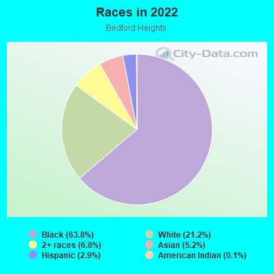
- 10,52863.8%Black
- 3,50421.2%White
- 1,1166.8%Two or more races
- 8565.2%Asian
- 4812.9%Hispanic or Latino
- 220.1%American Indian
Distribution of median household income
![Distribution of median household income]()
- 471Less than $10,000
- 1,137$10,000 to $19,999
- 2,386$20,000 to $29,999
- 701$30,000 to $39,999
- 893$40,000 to $49,999
- 827$50,000 to $59,999
- 973$60,000 to $74,999
- 832$75,000 to $99,999
- 605$100,000 to $124,999
- 495$125,000 to $149,999
- 541$150,000 to $199,999
- 607$200,000 or more

Distribution of owner-occupied house/condo value
![Distribution of owner-occupied house/condo value]()
- 3,999Less than $50,000
- 6,196$50,000 to $99,999
- 977$100,000 to $149,999
- 684$150,000 to $199,999
- 429$200,000 to $249,999
- 269$250,000 to $299,999
- 796$300,000 to $399,999
- 478$400,000 to $499,999
- 510$500,000 to $749,999
- 294$750,000 to $999,999
- 137$1,000,000 or more

Distribution of rent paid by renters
![Distribution of rent paid by renters]()
- 77Less than $100
- 110$100 to $199
- 501$200 to $299
- 171$300 to $399
- 411$400 to $499
- 703$500 to $599
- 4,752$600 to $699
- 1,201$700 to $799
- 2,452$800 to $899
- 1,601$900 to $999
- 1,020$1,000 to $1,249
- 347$1,250 to $1,499
- 4$1,500 to $1,999
- 1,422$2,000 or more

| Males: | 7,406 |
| Females: | 7,529 |
Males:
| This neighborhood: | |
| Whole city: |
| This neighborhood: | |
| Whole city: |
Percentage of family households:
| Bedford Heights: | 36.2% |
| Bedford: | 34.3% |
| Here: | 25.7% |
| Bedford: | 25.8% |
Percentage of married-couple families with children (among all households):
| Bedford Heights: | 13.7% |
| Bedford: | 13.3% |
Percentage of single-mother households (among all households):
| Bedford Heights: | 30.1% |
| Bedford: | 27.1% |
Percentage of never married males 15 years old and over:
Percentage of never married females 15 years old and over:
| Bedford Heights: | 22.8% |
| Bedford: | 20.7% |
Percentage of never married females 15 years old and over:
| Bedford Heights: | 21.3% |
| city: | 18.9% |
Percentage of people that speak English not well or not at all:
| Bedford Heights: | 0.3% |
| Bedford: | 0.6% |
Percentage of people born in this state:
Percentage of people born in another U.S. state:
Percentage of native residents but born outside the U.S.:
Percentage of foreign born residents:
| Here: | 81.3% |
| Bedford: | 83.1% |
Percentage of people born in another U.S. state:
| Bedford Heights: | 15.9% |
| Bedford: | 12.3% |
Percentage of native residents but born outside the U.S.:
| Here: | 0.6% |
| city: | 1.4% |
Percentage of foreign born residents:
| Here: | 2.5% |
| Bedford: | 3.2% |
Owner-occupied
Renter-occupied

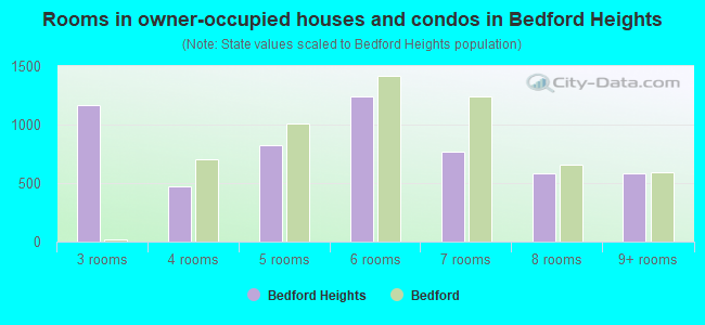
- Rooms in owner-occupied houses and condos in Bedford Heights
- 01 room
- 02 rooms
- 1,1643 rooms
- 4714 rooms
- 8225 rooms
- 1,2456 rooms
- 7717 rooms
- 5818 rooms
- 5829+ rooms
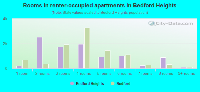
- Rooms in renter-occupied apartments in Bedford Heights
- 1961 room
- 2,5282 rooms
- 1,7173 rooms
- 1,9564 rooms
- 9125 rooms
- 1,0126 rooms
- 2527 rooms
- 8798 rooms
- 949+ rooms
Owner-occupied
Renter-occupied
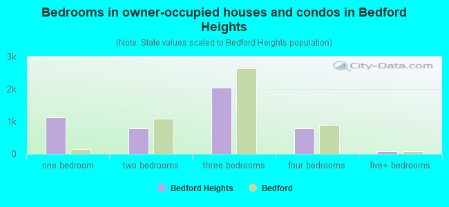
- Bedrooms in owner-occupied houses and condos in Bedford Heights
- 0no bedroom
- 1,1311 bedroom
- 7872 bedrooms
- 2,0443 bedrooms
- 7934 bedrooms
- 865+ bedrooms
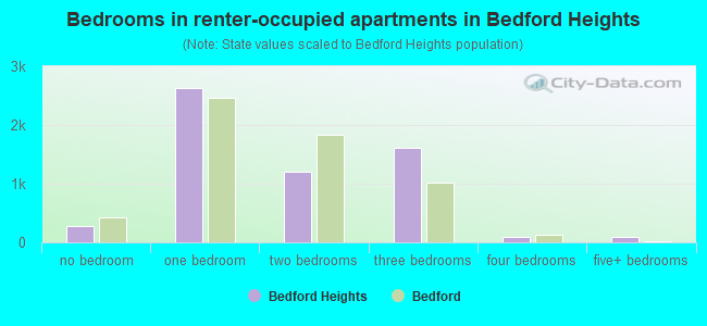
- Bedrooms in renter-occupied apartments in Bedford Heights
- 279no bedroom
- 2,6331 bedroom
- 1,2002 bedrooms
- 1,6033 bedrooms
- 924 bedrooms
- 895+ bedrooms
Average number of cars or other vehicles available in houses/condos:
Average number of cars or other vehicles available in apartments:
| This neighborhood: | |
| Bedford: |
Average number of cars or other vehicles available in apartments:
| Here: | |
| city: |
Percentage of units with a mortgage:
| Bedford Heights: | 63.8% |
| Bedford: | 64.6% |
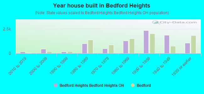
- Year house built in Bedford Heights
- 02020 or later
- 1532010 to 2019
- 4462000 to 2009
- 1531990 to 1999
- 9821980 to 1989
- 4651970 to 1979
- 1,2931960 to 1969
- 2,3211950 to 1959
- 1,8671940 to 1949
- 1,0601939 or earlier
City-data.com crime index for city in 2020 (higher means more crime):
| City: | 81.2 |
| U.S. average: | 219.5 |
Travel time to work (commute)
![Travel time to work (commute)]()
- 135Less than 5 minutes
- 5505 to 9 minutes
- 1,27010 to 14 minutes
- 84315 to 19 minutes
- 1,39520 to 24 minutes
- 63625 to 29 minutes
- 1,14130 to 34 minutes
- 15535 to 39 minutes
- 30940 to 44 minutes
- 33045 to 59 minutes
- 43160 to 89 minutes
- 15890 or more minutes

Means of transportation to work
![Means of transportation to work]()
- 87.6%5,533Drove a car alone
- 7.4%465Carpooled
- 1.7%110Bus
- 1.0%63Long-distance train or commuter rail
- 3.3%210Taxi
- 13.4%847Walked
- 0.1%8Other means
- 8.7%548Worked at home

Time leaving home to go to work
![Time leaving home to go to work]()
- 29512:00 a.m. to 4:59 a.m.
- 2645:00 a.m. to 5:29 a.m.
- 1955:30 a.m. to 5:59 a.m.
- 5576:00 a.m. to 6:29 a.m.
- 3886:30 a.m. to 6:59 a.m.
- 7757:00 a.m. to 7:29 a.m.
- 1,0817:30 a.m. to 7:59 a.m.
- 8598:00 a.m. to 8:29 a.m.
- 5428:30 a.m. to 8:59 a.m.
- 5189:00 a.m. to 9:59 a.m.
- 17310:00 a.m. to 10:59 a.m.
- 10611:00 a.m. to 11:59 a.m.
- 69012:00 p.m. to 3:59 p.m.
- 6834:00 p.m. to 11:59 p.m.

Occupations of males:
- Percentage of males in management occupations (except farmers):
Here: 17.6% city: 13.4%
- Percentage of males in business and financial operations occupations:
Here: 1.0% city: 3.0%
- Percentage of males in computer and mathematical occupations:
Here: 2.4% city: 2.3%
- Percentage of males in architecture and engineering occupations:
Here: 5.2% city: 1.8%
- Percentage of males in life, physical, and social science occupations:
Here: 2.8% city: 0.2%
- Percentage of males in community and social services occupations:
Here: 4.7% city: 4.8%
- Percentage of males in arts, design, entertainment, sports, and media occupations:
Here: 22.8% city: 0.0%
- Percentage of males in healthcare practitioners and technical occupations:
Here: 1.3% city: 1.1%
- Percentage of males in service occupations:
Here: 15.4% city: 10.9%
- Percentage of males in sales and office occupations:
Here: 21.3% city: 13.0%
- Percentage of males in construction, extraction, and maintenance occupations:
Here: 3.9% city: 5.6%
- Percentage of males in production occupations:
Here: 8.4% city: 12.4%
- Percentage of males in transportation occupations:
Here: 3.9% city: 8.1%
- Percentage of males in material moving occupations:
Here: 3.7% city: 10.9%
Occupations of females:
- Percentage of females in management occupations (except farmers):
Here: 9.2% city: 9.4%
- Percentage of females in business and financial operations occupations:
Here: 6.1% city: 7.3%
- Percentage of females in community and social services occupations:
Here: 1.7% city: 2.7%
- Percentage of females in education, training, and library occupations:
Here: 2.3% city: 4.6%
- Percentage of females in healthcare practitioners and technical occupations:
Here: 13.8% city: 3.1%
- Percentage of females in service occupations:
Here: 19.0% city: 16.2%
- Percentage of females in sales and office occupations:
Here: 36.8% city: 40.8%
- Percentage of females in production occupations:
Here: 6.3% city: 7.2%
- Percentage of females in transportation occupations:
Here: 2.4% city: 1.4%
Education in this neighborhood (subdivision or community):
- Percentage of people 3 years and older in K-12 schools:
Bedford Heights: 28.6% Bedford: 15.7%
- Percentage of people 3 years and older in undergraduate colleges:
Bedford Heights: 1.2% Bedford: 2.8%
- Percentage of people 3 years and older in grad. or professional schools:
Bedford Heights: 2.7% Bedford: 0.8%
- Percentage of students K-12 enrolled in private schools:
Bedford Heights: 47.5% Bedford: 21.9%
Percentage of population below poverty level:
| Bedford Heights: | 14.1% |
| Bedford: | 11.6% |
Percentage of married-couple families with both working:
| Bedford Heights: | 57.4% |
| Bedford: | 66.9% |

- 66.9%Utility gas
- 15.0%Electricity
- 6.6%Fuel oil, kerosene, etc.
- 5.1%Bottled, tank, or LP gas
- 4.5%No fuel used
- 1.1%Other fuel
- 0.8%Wood
Limited-access highways (interstate or state) in this neighborhood:
Outerbelt East Fwy (I- 271, I- 480)
Length: 6.77 miles
Directions: N-S, SW-NE
Directions: N-S, SW-NE
Outerbelt South Fwy (I- 480)
Length: 2.87 miles
Directions: N-S, SE-NW, SW-NE
Directions: N-S, SE-NW, SW-NE
Highways in this neighborhood:
Richmond Rd (State Rte 175)
Length: 3.81 miles
Directions: N-S, SE-NW, SW-NE
Address range: 5000 to 26998
Directions: N-S, SE-NW, SW-NE
Address range: 5000 to 26998
Aurora Rd (State Rte 43)
Length: 3.15 miles
Directions: E-W, N-S, SE-NW
Address range: 21206 to 27533
Directions: E-W, N-S, SE-NW
Address range: 21206 to 27533
State Rte 8 (Northfield Rd)
Length: 1.27 miles
Directions: N-S, SW-NE
Address range: 400 to 5608
Directions: N-S, SW-NE
Address range: 400 to 5608
State Rte 17 (Libby Rd)
Length: 0.87 miles
Direction: E-W
Address range: 21800 to 23299
Direction: E-W
Address range: 21800 to 23299
US Hwy 422 Alt
Length: 0.24 miles
Directions: E-W, SW-NE
Directions: E-W, SW-NE
Roads and streets:
Miles Rd (N Miles Rd)
Length: 2.56 miles
Directions: E-W, SE-NW
Address range: 22225 to 27329
Directions: E-W, SE-NW
Address range: 22225 to 27329
Columbus Rd (Columbus St)
Length: 2.08 miles
Direction: E-W
Address range: 589 to 26999
Direction: E-W
Address range: 589 to 26999
Rockside Rd
Length: 1.96 miles
Direction: E-W
Address range: 22000 to 25404
Direction: E-W
Address range: 22000 to 25404
Solon Rd
Length: 1.95 miles
Directions: E-W, SE-NW
Address range: 300 to 26999
Directions: E-W, SE-NW
Address range: 300 to 26999
Forbes Rd
Length: 1.38 miles
Direction: E-W
Address range: 24142 to 26599
Direction: E-W
Address range: 24142 to 26599
Cannon Rd
Length: 1.22 miles
Directions: E-W, N-S, SE-NW
Address range: 23000 to 27299
Directions: E-W, N-S, SE-NW
Address range: 23000 to 27299
Randolph Rd
Length: 1.22 miles
Directions: E-W, N-S, SE-NW, SW-NE
Address range: 6064 to 25499
Directions: E-W, N-S, SE-NW, SW-NE
Address range: 6064 to 25499
Bartlett Rd
Length: 1.22 miles
Directions: E-W, N-S, SE-NW, SW-NE
Address range: 300 to 5799
Directions: E-W, N-S, SE-NW, SW-NE
Address range: 300 to 5799
Perkins Rd
Length: 1.12 miles
Directions: E-W, N-S, SE-NW, SW-NE
Address range: 5300 to 5799
Directions: E-W, N-S, SE-NW, SW-NE
Address range: 5300 to 5799
Eldridge Blvd
Length: 1.01 miles
Directions: E-W, N-S, SE-NW, SW-NE
Address range: 6100 to 24999
Directions: E-W, N-S, SE-NW, SW-NE
Address range: 6100 to 24999
Park Rd
Length: 0.99 miles
Directions: E-W, SE-NW
Address range: 24400 to 25999
Directions: E-W, SE-NW
Address range: 24400 to 25999
Buckthorn Rd
Length: 0.96 miles
Directions: E-W, SE-NW
Address range: 24900 to 26999
Directions: E-W, SE-NW
Address range: 24900 to 26999
Archer Rd
Length: 0.88 miles
Directions: E-W, N-S, SE-NW, SW-NE
Address range: 828 to 1199
Directions: E-W, N-S, SE-NW, SW-NE
Address range: 828 to 1199
Sunset Dr
Length: 0.81 miles
Directions: N-S, SE-NW, SW-NE
Address range: 5800 to 6299
Directions: N-S, SE-NW, SW-NE
Address range: 5800 to 6299
Cambridge Dr
Length: 0.77 miles
Directions: E-W, SE-NW, SW-NE
Address range: 25400 to 26999
Directions: E-W, SE-NW, SW-NE
Address range: 25400 to 26999
Bedford Chagrin Pkwy
Length: 0.75 miles
Directions: E-W, SE-NW
Directions: E-W, SE-NW
Naiman Pkwy
Length: 0.72 miles
Directions: E-W, N-S, SE-NW
Address range: 5000 to 5499
Directions: E-W, N-S, SE-NW
Address range: 5000 to 5499
Ronan Rd
Length: 0.59 miles
Direction: E-W
Address range: 24200 to 25486
Direction: E-W
Address range: 24200 to 25486
Kimberly Dr
Length: 0.57 miles
Directions: N-S, SW-NE
Address range: 5800 to 6099
Directions: N-S, SW-NE
Address range: 5800 to 6099
Fargo Ave
Length: 0.56 miles
Directions: E-W, SE-NW
Address range: 25800 to 26899
Directions: E-W, SE-NW
Address range: 25800 to 26899
Vickie Ln
Length: 0.51 miles
Direction: N-S
Address range: 5500 to 5799
Direction: N-S
Address range: 5500 to 5799
Meadow Ln
Length: 0.51 miles
Direction: N-S
Address range: 5500 to 5799
Direction: N-S
Address range: 5500 to 5799
Columbia Dr
Length: 0.51 miles
Direction: N-S
Address range: 5500 to 5899
Direction: N-S
Address range: 5500 to 5899
Robertdale Rd
Length: 0.50 miles
Direction: N-S
Address range: 5700 to 6199
Direction: N-S
Address range: 5700 to 6199
White Pine Dr
Length: 0.49 miles
Directions: E-W, N-S
Address range: 5801 to 6099
Directions: E-W, N-S
Address range: 5801 to 6099
Comstock Rd
Length: 0.48 miles
Directions: E-W, N-S, SE-NW
Address range: 5449 to 23799
Directions: E-W, N-S, SE-NW
Address range: 5449 to 23799
Sweet Birch Dr
Length: 0.47 miles
Direction: N-S
Address range: 5800 to 6099
Direction: N-S
Address range: 5800 to 6099
Lori Dr
Length: 0.46 miles
Directions: E-W, N-S, SW-NE
Address range: 5500 to 23499
Directions: E-W, N-S, SW-NE
Address range: 5500 to 23499
Randy Rd
Length: 0.46 miles
Directions: E-W, N-S, SE-NW
Address range: 5800 to 6099
Directions: E-W, N-S, SE-NW
Address range: 5800 to 6099
Picone Ln
Length: 0.45 miles
Direction: E-W
Address range: 24600 to 25399
Direction: E-W
Address range: 24600 to 25399
Price Rd
Length: 0.43 miles
Direction: E-W
Address range: 24600 to 25399
Direction: E-W
Address range: 24600 to 25399
S Perkins Rd
Length: 0.43 miles
Direction: N-S
Address range: 6000 to 6312
Direction: N-S
Address range: 6000 to 6312
Scarlet Oak Dr
Length: 0.41 miles
Directions: E-W, N-S, SE-NW
Address range: 5800 to 24799
Directions: E-W, N-S, SE-NW
Address range: 5800 to 24799
Woodline Rd
Length: 0.41 miles
Directions: E-W, SE-NW
Address range: 24700 to 25699
Directions: E-W, SE-NW
Address range: 24700 to 25699
Sycamore Dr
Length: 0.39 miles
Directions: E-W, N-S, SE-NW, SW-NE
Address range: 2000 to 2099
Directions: E-W, N-S, SE-NW, SW-NE
Address range: 2000 to 2099
Gary Ave
Length: 0.39 miles
Directions: N-S, SE-NW
Address range: 5350 to 5699
Directions: N-S, SE-NW
Address range: 5350 to 5699
Sandalwood Rd
Length: 0.38 miles
Direction: E-W
Address range: 21900 to 22699
Direction: E-W
Address range: 21900 to 22699
Meuti Dr
Length: 0.38 miles
Direction: SE-NW
Direction: SE-NW
Marra Dr
Length: 0.37 miles
Directions: N-S, SW-NE
Address range: 5800 to 6099
Directions: N-S, SW-NE
Address range: 5800 to 6099
Bear Creek Dr
Length: 0.37 miles
Directions: N-S, SW-NE
Address range: 5800 to 6099
Directions: N-S, SW-NE
Address range: 5800 to 6099
Tupelo Dr
Length: 0.37 miles
Directions: N-S, SW-NE
Address range: 6600 to 6799
Directions: N-S, SW-NE
Address range: 6600 to 6799
Laing Rd
Length: 0.36 miles
Directions: E-W, N-S, SE-NW, SW-NE
Address range: 24000 to 24599
Directions: E-W, N-S, SE-NW, SW-NE
Address range: 24000 to 24599
Carlton Dr
Length: 0.35 miles
Directions: E-W, N-S
Address range: 5500 to 5799
Directions: E-W, N-S
Address range: 5500 to 5799
Basswood Dr
Length: 0.34 miles
Directions: N-S, SE-NW
Address range: 6530 to 6799
Directions: N-S, SE-NW
Address range: 6530 to 6799
Mardale Ave
Length: 0.33 miles
Direction: N-S
Address range: 5200 to 5499
Direction: N-S
Address range: 5200 to 5499
Fairtree Rd
Length: 0.33 miles
Direction: N-S
Address range: 5200 to 5499
Direction: N-S
Address range: 5200 to 5499
Sherborne Rd
Length: 0.32 miles
Direction: E-W
Address range: 24000 to 24799
Direction: E-W
Address range: 24000 to 24799
Ridgeline Dr
Length: 0.32 miles
Directions: E-W, SE-NW
Address range: 24300 to 24961
Directions: E-W, SE-NW
Address range: 24300 to 24961
Lehman Dr
Length: 0.31 miles
Direction: N-S
Address range: 5800 to 6108
Direction: N-S
Address range: 5800 to 6108
Tamarind Dr
Length: 0.31 miles
Directions: N-S, SW-NE
Address range: 6589 to 6759
Directions: N-S, SW-NE
Address range: 6589 to 6759
Louis Rd
Length: 0.31 miles
Directions: E-W, SW-NE
Address range: 21700 to 22199
Directions: E-W, SW-NE
Address range: 21700 to 22199
Cranfield Rd
Length: 0.31 miles
Direction: E-W
Address range: 22900 to 23599
Direction: E-W
Address range: 22900 to 23599
Washburne Rd
Length: 0.30 miles
Direction: N-S
Address range: 5300 to 5499
Direction: N-S
Address range: 5300 to 5499
Uppingham Rd
Length: 0.28 miles
Directions: E-W, N-S
Address range: 24200 to 24699
Directions: E-W, N-S
Address range: 24200 to 24699
Mark Dr
Length: 0.27 miles
Directions: N-S, SW-NE
Address range: 6069 to 6299
Directions: N-S, SW-NE
Address range: 6069 to 6299
Suwanee Ave
Length: 0.27 miles
Direction: E-W
Address range: 24900 to 25429
Direction: E-W
Address range: 24900 to 25429
Millbrook Rd
Length: 0.26 miles
Directions: N-S, SE-NW
Address range: 5400 to 5499
Directions: N-S, SE-NW
Address range: 5400 to 5499
Balsam Dr
Length: 0.26 miles
Direction: N-S
Address range: 3400 to 6798
Direction: N-S
Address range: 3400 to 6798
Valley Ln
Length: 0.24 miles
Directions: E-W, N-S, SW-NE
Address range: 5563 to 5611
Directions: E-W, N-S, SW-NE
Address range: 5563 to 5611
Deer Ct
Length: 0.24 miles
Directions: N-S, SE-NW
Address range: 6600 to 6799
Directions: N-S, SE-NW
Address range: 6600 to 6799
Dennisport Dr
Length: 0.24 miles
Direction: E-W
Address range: 26200 to 26399
Direction: E-W
Address range: 26200 to 26399
Robinia Dr
Length: 0.23 miles
Direction: E-W
Address range: 24100 to 24799
Direction: E-W
Address range: 24100 to 24799
Strathallan Dr
Length: 0.22 miles
Directions: N-S, SW-NE
Address range: 6200 to 6399
Directions: N-S, SW-NE
Address range: 6200 to 6399
Norton Rd
Length: 0.22 miles
Directions: E-W, SW-NE
Address range: 21700 to 21999
Directions: E-W, SW-NE
Address range: 21700 to 21999
Sandhurst Rd
Length: 0.21 miles
Direction: E-W
Address range: 25000 to 25499
Direction: E-W
Address range: 25000 to 25499
Fenlake Rd
Length: 0.21 miles
Directions: N-S, SW-NE
Address range: 5400 to 5499
Directions: N-S, SW-NE
Address range: 5400 to 5499
Hedgeline Dr
Length: 0.21 miles
Directions: E-W, N-S, SE-NW
Address range: 6600 to 6749
Directions: E-W, N-S, SE-NW
Address range: 6600 to 6749
Omega Ave
Length: 0.20 miles
Direction: N-S
Address range: 5400 to 5799
Direction: N-S
Address range: 5400 to 5799
Taylor Dr
Length: 0.20 miles
Direction: N-S
Address range: 5000 to 5139
Direction: N-S
Address range: 5000 to 5139
South Ln
Length: 0.20 miles
Direction: E-W
Address range: 23600 to 23899
Direction: E-W
Address range: 23600 to 23899
Westlawn Rd
Length: 0.19 miles
Direction: N-S
Address range: 5000 to 5199
Direction: N-S
Address range: 5000 to 5199
Erie St
Length: 0.18 miles
Direction: N-S
Direction: N-S
Staghorn Dr
Length: 0.18 miles
Direction: E-W
Address range: 24300 to 24799
Direction: E-W
Address range: 24300 to 24799
Easy St
Length: 0.18 miles
Direction: E-W
Address range: 25200 to 25499
Direction: E-W
Address range: 25200 to 25499
Roy Ave
Length: 0.17 miles
Direction: E-W
Address range: 21900 to 22399
Direction: E-W
Address range: 21900 to 22399
Bedford St
Length: 0.16 miles
Direction: SW-NE
Address range: 5300 to 5499
Direction: SW-NE
Address range: 5300 to 5499
Rugby Ct
Length: 0.16 miles
Direction: E-W
Address range: 24000 to 24499
Direction: E-W
Address range: 24000 to 24499
Corbin Dr
Length: 0.16 miles
Direction: N-S
Address range: 5000 to 23899
Direction: N-S
Address range: 5000 to 23899
Majestic Pkwy
Length: 0.16 miles
Direction: SW-NE
Address range: 5300 to 5499
Direction: SW-NE
Address range: 5300 to 5499
Ridgeway Dr
Length: 0.15 miles
Directions: N-S, SW-NE
Address range: 6000 to 6199
Directions: N-S, SW-NE
Address range: 6000 to 6199
Wood St
Length: 0.15 miles
Direction: E-W
Direction: E-W
Oxford Ct
Length: 0.15 miles
Direction: N-S
Address range: 6200 to 6399
Direction: N-S
Address range: 6200 to 6399
Holly Rd
Length: 0.14 miles
Direction: N-S
Address range: 5300 to 5499
Direction: N-S
Address range: 5300 to 5499
Harrow Ct
Length: 0.14 miles
Directions: E-W, N-S
Address range: 6200 to 6299
Directions: E-W, N-S
Address range: 6200 to 6299
Applegate Rd
Length: 0.14 miles
Direction: E-W
Address range: 20746 to 21607
Direction: E-W
Address range: 20746 to 21607
Park Pl
Length: 0.14 miles
Direction: E-W
Address range: 1 to 99
Direction: E-W
Address range: 1 to 99
Metro Ct
Length: 0.14 miles
Directions: N-S, SE-NW
Address range: 6400 to 6499
Directions: N-S, SE-NW
Address range: 6400 to 6499
Hist Ave
Length: 0.13 miles
Direction: E-W
Direction: E-W
Grimes Rd
Length: 0.12 miles
Direction: E-W
Address range: 22564 to 22799
Direction: E-W
Address range: 22564 to 22799
Lamson Rd
Length: 0.12 miles
Direction: N-S
Address range: 7200 to 7233
Direction: N-S
Address range: 7200 to 7233
Holiday Hills Ct
Length: 0.12 miles
Directions: E-W, N-S, SW-NE
Address range: 6300 to 6399
Directions: E-W, N-S, SW-NE
Address range: 6300 to 6399
Tonbridge Ct
Length: 0.11 miles
Directions: N-S, SE-NW, SW-NE
Address range: 6250 to 6399
Directions: N-S, SE-NW, SW-NE
Address range: 6250 to 6399
Kennedy Dr
Length: 0.11 miles
Direction: E-W
Address range: 23850 to 24099
Direction: E-W
Address range: 23850 to 24099
S Perkins Ct
Length: 0.11 miles
Directions: N-S, SE-NW
Address range: 6300 to 6399
Directions: N-S, SE-NW
Address range: 6300 to 6399
Rankin Rd
Length: 0.11 miles
Directions: E-W, SE-NW
Address range: 22500 to 22699
Directions: E-W, SE-NW
Address range: 22500 to 22699
Eaton Ct
Length: 0.10 miles
Direction: N-S
Address range: 6000 to 6199
Direction: N-S
Address range: 6000 to 6199
State Ln
Length: 0.09 miles
Directions: E-W, N-S, SW-NE
Directions: E-W, N-S, SW-NE
Green Ridge Dr
Length: 0.09 miles
Directions: E-W, SW-NE
Address range: 6200 to 6251
Directions: E-W, SW-NE
Address range: 6200 to 6251
Chinkapin Ct
Length: 0.09 miles
Directions: N-S, SW-NE
Address range: 6700 to 6799
Directions: N-S, SW-NE
Address range: 6700 to 6799
Pau Pau Ct
Length: 0.09 miles
Directions: E-W, SW-NE
Address range: 6500 to 6599
Directions: E-W, SW-NE
Address range: 6500 to 6599
Kane Rd
Length: 0.09 miles
Direction: E-W
Address range: 22600 to 22799
Direction: E-W
Address range: 22600 to 22799
David Dr
Length: 0.08 miles
Direction: E-W
Address range: 23850 to 24099
Direction: E-W
Address range: 23850 to 24099
Lynbrook Dr
Length: 0.08 miles
Direction: N-S
Address range: 7200 to 7217
Direction: N-S
Address range: 7200 to 7217
Somerville Dr
Length: 0.07 miles
Direction: N-S
Address range: 7200 to 7218
Direction: N-S
Address range: 7200 to 7218
Raynham Dr
Length: 0.06 miles
Direction: N-S
Address range: 7200 to 7224
Direction: N-S
Address range: 7200 to 7224
Lincoln Dr
Length: 0.06 miles
Directions: E-W, SW-NE
Address range: 23600 to 23699
Directions: E-W, SW-NE
Address range: 23600 to 23699
Campton Ct
Length: 0.06 miles
Direction: E-W
Address range: 5400 to 5499
Direction: E-W
Address range: 5400 to 5499
Bluestone Lnae
Length: 0.06 miles
Directions: E-W, N-S
Directions: E-W, N-S
Raymond St
Length: 0.06 miles
Direction: E-W
Address range: 21522 to 21649
Direction: E-W
Address range: 21522 to 21649
Larch Ct
Length: 0.05 miles
Direction: N-S
Address range: 6700 to 6799
Direction: N-S
Address range: 6700 to 6799
Juniper Ct
Length: 0.05 miles
Direction: SW-NE
Address range: 4000 to 4099
Direction: SW-NE
Address range: 4000 to 4099
Kentucky Dr
Length: 0.03 miles
Direction: N-S
Direction: N-S
Railroad features:
Erie-Lackawanna RR
Length: 5.60 miles
Directions: E-W, SE-NW
Directions: E-W, SE-NW
Wheeling and Lake RR
Length: 2.02 miles
Directions: E-W, SE-NW
Directions: E-W, SE-NW
Conrail RR (Norfolk Southern Rlwy)
Length: 0.30 miles
Direction: E-W
Direction: E-W
Other features:
Tinkers Crk
Length: 2.30 miles
Directions: E-W, N-S, SE-NW, SW-NE
Directions: E-W, N-S, SE-NW, SW-NE