Belmont neighborhood in Dayton, Ohio (OH), 45420 detailed profile
Settings
X

Business Search - 14 Million verified businesses
Area: 1.869 square miles
Population: 9,519
Population density:
| Belmont: | 5,093 people per square mile |
| Dayton: | 2,437 people per square mile |

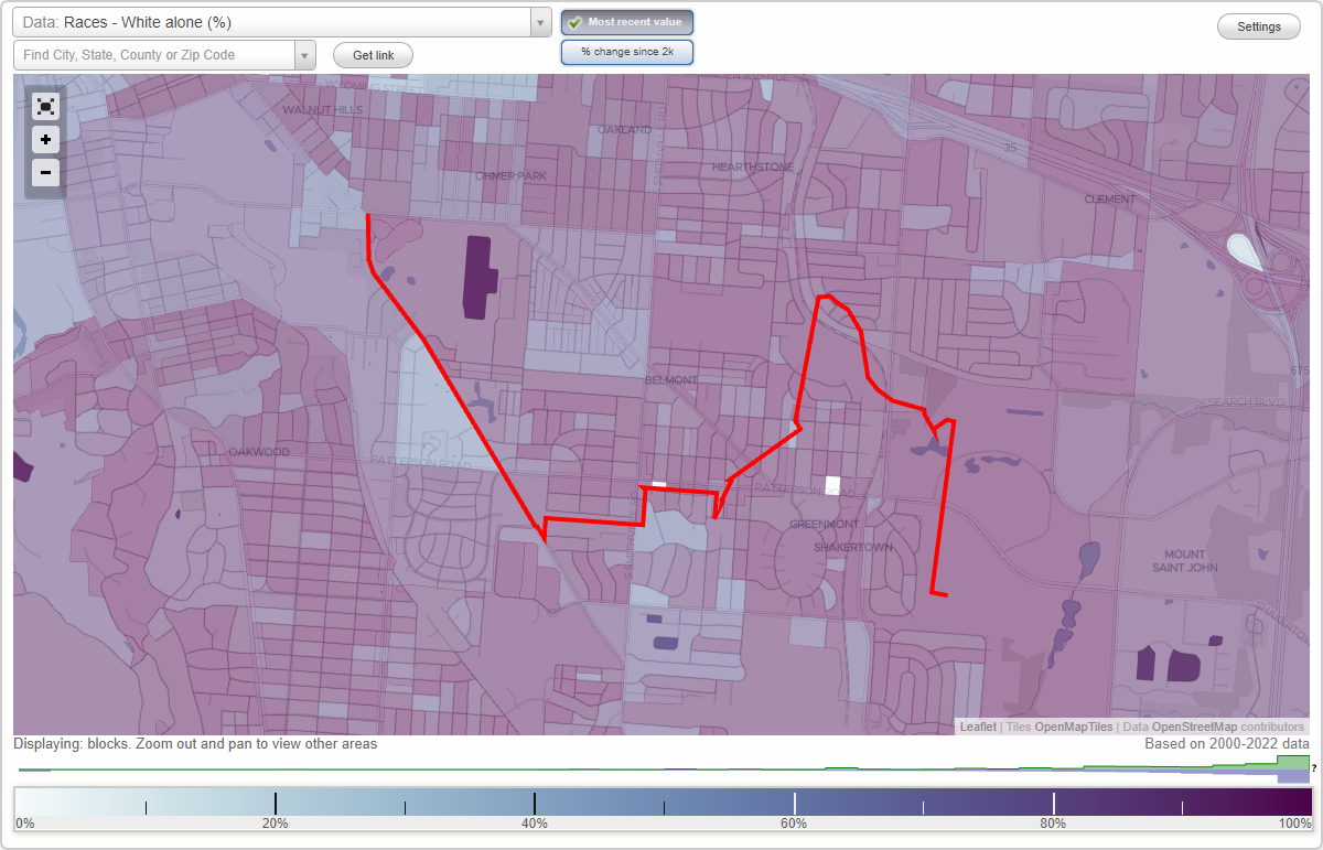
- 8,40576.5%White
- 6485.9%Hispanic or Latino
- 4574.2%Black
- 4464.1%Two or more races
- 4424.0%Asian
- 4213.8%Some other race
- 840.8%American Indian
- 860.8%Native Hawaiian and Other
Pacific Islander

Median household income in 2022:
| Belmont: | $52,798 |
| Dayton: | $43,780 |
Distribution of median household income
![Distribution of median household income]()
- 613Less than $10,000
- 934$10,000 to $19,999
- 554$20,000 to $29,999
- 762$30,000 to $39,999
- 784$40,000 to $49,999
- 702$50,000 to $59,999
- 590$60,000 to $74,999
- 733$75,000 to $99,999
- 402$100,000 to $124,999
- 307$125,000 to $149,999
- 228$150,000 to $199,999
- 349$200,000 or more

Distribution of owner-occupied house/condo value
![Distribution of owner-occupied house/condo value]()
- 1,025Less than $50,000
- 2,498$50,000 to $99,999
- 1,033$100,000 to $149,999
- 595$150,000 to $199,999
- 210$200,000 to $249,999
- 61$250,000 to $299,999
- 105$300,000 to $399,999
- 153$400,000 to $499,999
- 74$500,000 to $749,999
- 178$1,000,000 or more

Distribution of rent paid by renters
![Distribution of rent paid by renters]()
- 222Less than $100
- 121$100 to $199
- 2,830$200 to $299
- 1,591$300 to $399
- 331$400 to $499
- 694$500 to $599
- 829$600 to $699
- 465$700 to $799
- 404$800 to $899
- 162$900 to $999
- 124$1,000 to $1,249
- 573$1,250 to $1,499
- 161$1,500 to $1,999
- 170$2,000 or more

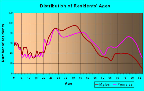
| Males: | 4,749 |
| Females: | 4,770 |
Males:
| This neighborhood: | 39.1 years |
| Whole city: | 36.3 years |
| This neighborhood: | 44.7 years |
| Whole city: | 40.2 years |
Average household size:
| Belmont: | 5.6 people |
| Dayton: | 1.9 people |
Percentage of family households:
| Belmont: | 31.5% |
| Dayton: | 32.6% |
| Here: | 29.4% |
| Dayton: | 24.5% |
Percentage of married-couple families with children (among all households):
| Belmont: | 24.3% |
| Dayton: | 19.6% |
Percentage of single-mother households (among all households):
| Belmont: | 31.6% |
| Dayton: | 24.9% |
Percentage of never married males 15 years old and over:
Percentage of never married females 15 years old and over:
| Belmont: | 19.5% |
| Dayton: | 24.8% |
Percentage of never married females 15 years old and over:
| Belmont: | 11.0% |
| city: | 23.3% |
Percentage of people that speak English not well or not at all:
| Belmont: | 0.7% |
| Dayton: | 1.6% |
Percentage of people born in this state:
Percentage of people born in another U.S. state:
Percentage of native residents but born outside the U.S.:
Percentage of foreign born residents:
| Here: | 75.8% |
| Dayton: | 68.0% |
Percentage of people born in another U.S. state:
| Belmont: | 20.1% |
| Dayton: | 26.4% |
Percentage of native residents but born outside the U.S.:
| Here: | 1.8% |
| city: | 1.7% |
Percentage of foreign born residents:
| Here: | 2.9% |
| Dayton: | 3.8% |
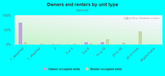
Owner-occupied
Renter-occupied

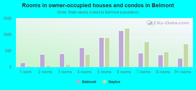
- Rooms in owner-occupied houses and condos in Belmont
- 1271 room
- 3932 rooms
- 4123 rooms
- 5884 rooms
- 9045 rooms
- 1,1256 rooms
- 4257 rooms
- 3688 rooms
- 2729+ rooms
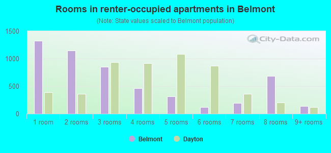
- Rooms in renter-occupied apartments in Belmont
- 1,3241 room
- 1,1512 rooms
- 8543 rooms
- 4634 rooms
- 3125 rooms
- 1216 rooms
- 1917 rooms
- 6868 rooms
- 1399+ rooms
Owner-occupied
Renter-occupied
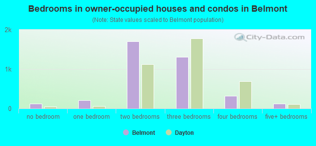
- Bedrooms in owner-occupied houses and condos in Belmont
- 127no bedroom
- 2111 bedroom
- 1,6992 bedrooms
- 1,3143 bedrooms
- 3254 bedrooms
- 1205+ bedrooms
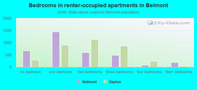
- Bedrooms in renter-occupied apartments in Belmont
- 671no bedroom
- 1,4401 bedroom
- 5962 bedrooms
- 4873 bedrooms
- 784 bedrooms
- 1895+ bedrooms
Average number of cars or other vehicles available in houses/condos:
Average number of cars or other vehicles available in apartments:
| This neighborhood: | 1.7 |
| Dayton: | 1.8 |
Average number of cars or other vehicles available in apartments:
| Here: | 1.1 |
| city: | 0.9 |
Percentage of units with a mortgage:
| Belmont: | 63.3% |
| Dayton: | 54.7% |
Average estimated value of detached houses in 2022 (73.0% of all units):
| Belmont: | $168,447 |
| Dayton: | $96,843 |
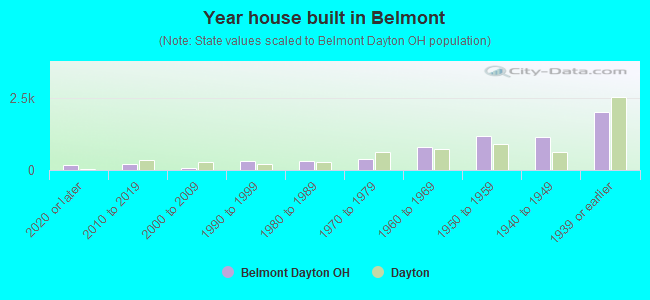
- Year house built in Belmont
- 1742020 or later
- 2202010 to 2019
- 682000 to 2009
- 3221990 to 1999
- 3091980 to 1989
- 3771970 to 1979
- 7941960 to 1969
- 1,1661950 to 1959
- 1,1331940 to 1949
- 2,0081939 or earlier
City-data.com crime index for city in 2020 (higher means more crime):
| City: | 559.8 |
| U.S. average: | 219.5 |
Travel time to work (commute)
![Travel time to work (commute)]()
- 181Less than 5 minutes
- 8735 to 9 minutes
- 63710 to 14 minutes
- 1,04815 to 19 minutes
- 1,05820 to 24 minutes
- 49925 to 29 minutes
- 49430 to 34 minutes
- 7035 to 39 minutes
- 2840 to 44 minutes
- 29545 to 59 minutes
- 11660 to 89 minutes
- 11290 or more minutes

Means of transportation to work
![Means of transportation to work]()
- 84.0%4,156Drove a car alone
- 9.0%443Carpooled
- 5.4%265Bus
- 2.7%132Taxi
- 0.4%22Bicycle
- 2.9%146Walked
- 3.6%177Other means
- 6.9%343Worked at home

Time leaving home to go to work
![Time leaving home to go to work]()
- 24612:00 a.m. to 4:59 a.m.
- 1015:00 a.m. to 5:29 a.m.
- 2625:30 a.m. to 5:59 a.m.
- 3276:00 a.m. to 6:29 a.m.
- 5896:30 a.m. to 6:59 a.m.
- 7627:00 a.m. to 7:29 a.m.
- 5967:30 a.m. to 7:59 a.m.
- 3358:00 a.m. to 8:29 a.m.
- 5518:30 a.m. to 8:59 a.m.
- 4259:00 a.m. to 9:59 a.m.
- 16210:00 a.m. to 10:59 a.m.
- 2811:00 a.m. to 11:59 a.m.
- 37012:00 p.m. to 3:59 p.m.
- 2824:00 p.m. to 11:59 p.m.

Occupations of males:
- Percentage of males in management occupations (except farmers):
Here: 6.5% city: 7.5%
- Percentage of males in business and financial operations occupations:
Here: 5.4% city: 2.7%
- Percentage of males in computer and mathematical occupations:
Here: 5.4% city: 3.2%
- Percentage of males in community and social services occupations:
Here: 1.1% city: 1.8%
- Percentage of males in education, training, and library occupations:
Here: 1.9% city: 3.4%
- Percentage of males in arts, design, entertainment, sports, and media occupations:
Here: 6.4% city: 2.9%
- Percentage of males in service occupations:
Here: 10.6% city: 18.0%
- Percentage of males in sales and office occupations:
Here: 15.6% city: 14.3%
- Percentage of males in construction, extraction, and maintenance occupations:
Here: 2.7% city: 5.2%
- Percentage of males in production occupations:
Here: 13.8% city: 13.4%
- Percentage of males in transportation occupations:
Here: 10.3% city: 8.0%
- Percentage of males in material moving occupations:
Here: 6.0% city: 8.4%
Occupations of females:
- Percentage of females in management occupations (except farmers):
Here: 5.2% city: 6.5%
- Percentage of females in business and financial operations occupations:
Here: 5.5% city: 4.8%
- Percentage of females in computer and mathematical occupations:
Here: 3.0% city: 1.8%
- Percentage of females in community and social services occupations:
Here: 1.3% city: 2.8%
- Percentage of females in education, training, and library occupations:
Here: 4.9% city: 7.0%
- Percentage of females in arts, design, entertainment, sports, and media occupations:
Here: 3.5% city: 1.9%
- Percentage of females in healthcare practitioners and technical occupations:
Here: 13.5% city: 8.6%
- Percentage of females in service occupations:
Here: 20.1% city: 24.7%
- Percentage of females in sales and office occupations:
Here: 29.5% city: 27.9%
- Percentage of females in production occupations:
Here: 4.3% city: 5.9%
- Percentage of females in transportation occupations:
Here: 1.7% city: 1.6%
- Percentage of females in material moving occupations:
Here: 5.4% city: 2.8%
Percentage of people 16-64 in Armed Forces:
| Belmont: | 0.8% |
| Dayton: | 1.6% |
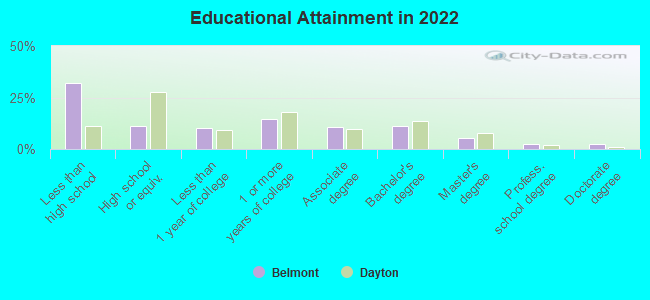
Education in this neighborhood (subdivision or community):
- Percentage of people 3 years and older in K-12 schools:
Belmont: 25.1% Dayton: 12.8%
- Percentage of people 3 years and older in undergraduate colleges:
Belmont: 8.0% Dayton: 11.0%
- Percentage of people 3 years and older in grad. or professional schools:
Belmont: 2.5% Dayton: 1.3%
- Percentage of students K-12 enrolled in private schools:
Belmont: 95.7% Dayton: 31.5%
Percentage of population below poverty level:
| Belmont: | 13.7% |
| Dayton: | 25.4% |
Median year owner moved in (as recorded in 2022):
| Belmont: | 2005 |
| Dayton: | 2008 |
Percentage of married-couple families with both working:
| Belmont: | 128.8% |
| Dayton: | 65.9% |
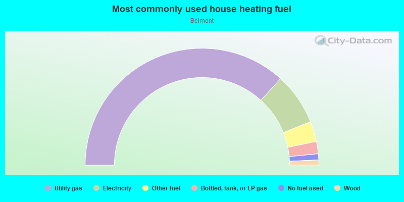
- 73.5%Utility gas
- 14.4%Electricity
- 5.6%Other fuel
- 3.4%Bottled, tank, or LP gas
- 1.7%No fuel used
- 1.4%Wood
Roads and streets:
Watervliet Ave
Length: 1.74 miles
Directions: E-W, SE-NW
Address range: 49 to 1699
Directions: E-W, SE-NW
Address range: 49 to 1699
Patterson Rd
Length: 1.45 miles
Direction: E-W
Address range: 1015 to 2288
Direction: E-W
Address range: 1015 to 2288
Woodbine Ave
Length: 1.22 miles
Directions: E-W, N-S, SW-NE
Address range: 3501 to 4590
Directions: E-W, N-S, SW-NE
Address range: 3501 to 4590
Bellaire Ave
Length: 1.20 miles
Directions: E-W, SW-NE
Address range: 70 to 1299
Directions: E-W, SW-NE
Address range: 70 to 1299
S Smithville Rd
Length: 1.15 miles
Direction: N-S
Address range: 2056 to 3399
Direction: N-S
Address range: 2056 to 3399
Nordale Ave
Length: 1.03 miles
Direction: E-W
Address range: 33 to 1099
Direction: E-W
Address range: 33 to 1099
Revere Ave
Length: 0.94 miles
Directions: N-S, SW-NE
Address range: 2100 to 3199
Directions: N-S, SW-NE
Address range: 2100 to 3199
Highridge Ave
Length: 0.72 miles
Directions: E-W, SE-NW, SW-NE
Address range: 800 to 4599
Directions: E-W, SE-NW, SW-NE
Address range: 800 to 4599
Morse Ave
Length: 0.69 miles
Directions: E-W, SE-NW, SW-NE
Address range: 400 to 1099
Directions: E-W, SE-NW, SW-NE
Address range: 400 to 1099
Farnham Ave
Length: 0.68 miles
Direction: E-W
Address range: 4000 to 4699
Direction: E-W
Address range: 4000 to 4699
Ewalt Ave
Length: 0.67 miles
Directions: E-W, SE-NW, SW-NE
Address range: 1400 to 2199
Directions: E-W, SE-NW, SW-NE
Address range: 1400 to 2199
Colwick Dr
Length: 0.66 miles
Direction: E-W
Address range: 1000 to 1399
Direction: E-W
Address range: 1000 to 1399
Donald Ave
Length: 0.66 miles
Directions: E-W, N-S, SW-NE
Address range: 500 to 1299
Directions: E-W, N-S, SW-NE
Address range: 500 to 1299
Reading Rd
Length: 0.65 miles
Direction: E-W
Address range: 4000 to 4599
Direction: E-W
Address range: 4000 to 4599
Kennedy Ave
Length: 0.57 miles
Direction: N-S
Address range: 2300 to 2899
Direction: N-S
Address range: 2300 to 2899
Chelsea Ave
Length: 0.56 miles
Directions: E-W, SE-NW, SW-NE
Address range: 800 to 1199
Directions: E-W, SE-NW, SW-NE
Address range: 800 to 1199
Hazel Ave
Length: 0.56 miles
Directions: N-S, SW-NE
Address range: 2400 to 2999
Directions: N-S, SW-NE
Address range: 2400 to 2999
Weng Ave
Length: 0.55 miles
Direction: E-W
Address range: 800 to 1399
Direction: E-W
Address range: 800 to 1399
Woodcliffe Ave
Length: 0.55 miles
Direction: E-W
Address range: 4100 to 4599
Direction: E-W
Address range: 4100 to 4599
Oakdale Ave
Length: 0.52 miles
Direction: E-W
Address range: 1100 to 1403
Direction: E-W
Address range: 1100 to 1403
Ferncliff Ave
Length: 0.50 miles
Directions: N-S, SW-NE
Address range: 1200 to 2899
Directions: N-S, SW-NE
Address range: 1200 to 2899
John Glenn Rd
Length: 0.50 miles
Directions: E-W, N-S, SE-NW
Address range: 2100 to 2699
Directions: E-W, N-S, SE-NW
Address range: 2100 to 2699
Springmont Ave
Length: 0.50 miles
Directions: E-W, N-S, SW-NE
Address range: 2400 to 2899
Directions: E-W, N-S, SW-NE
Address range: 2400 to 2899
Martel Dr
Length: 0.49 miles
Direction: N-S
Address range: 2700 to 3399
Direction: N-S
Address range: 2700 to 3399
Kenmore Ave
Length: 0.48 miles
Direction: N-S
Address range: 2800 to 3399
Direction: N-S
Address range: 2800 to 3399
Ashland Ave
Length: 0.47 miles
Direction: E-W
Address range: 1100 to 1399
Direction: E-W
Address range: 1100 to 1399
Amesborough Rd
Length: 0.46 miles
Directions: E-W, N-S, SE-NW, SW-NE
Address range: 4500 to 4899
Directions: E-W, N-S, SE-NW, SW-NE
Address range: 4500 to 4899
Russet Ave
Length: 0.45 miles
Direction: N-S
Address range: 1900 to 2399
Direction: N-S
Address range: 1900 to 2399
Kemper Ave
Length: 0.44 miles
Direction: E-W
Address range: 1100 to 1399
Direction: E-W
Address range: 1100 to 1399
Wayland Ave
Length: 0.43 miles
Directions: N-S, SW-NE
Address range: 2600 to 2999
Directions: N-S, SW-NE
Address range: 2600 to 2999
Whiteoak Dr
Length: 0.43 miles
Directions: N-S, SE-NW, SW-NE
Address range: 2800 to 3399
Directions: N-S, SE-NW, SW-NE
Address range: 2800 to 3399
Mundale Ave
Length: 0.43 miles
Directions: E-W, N-S, SW-NE
Address range: 2300 to 2599
Directions: E-W, N-S, SW-NE
Address range: 2300 to 2599
Croyden Dr
Length: 0.43 miles
Directions: E-W, SE-NW
Address range: 947 to 1199
Directions: E-W, SE-NW
Address range: 947 to 1199
Russell Ave
Length: 0.38 miles
Direction: E-W
Address range: 1300 to 1853
Direction: E-W
Address range: 1300 to 1853
Mayflower Ave
Length: 0.37 miles
Directions: E-W, N-S, SE-NW
Address range: 2100 to 2299
Directions: E-W, N-S, SE-NW
Address range: 2100 to 2299
Eastgate Ave
Length: 0.37 miles
Directions: E-W, N-S, SE-NW, SW-NE
Address range: 4600 to 4999
Directions: E-W, N-S, SE-NW, SW-NE
Address range: 4600 to 4999
Newgate Ave
Length: 0.36 miles
Directions: E-W, N-S, SE-NW, SW-NE
Address range: 2100 to 2299
Directions: E-W, N-S, SE-NW, SW-NE
Address range: 2100 to 2299
Fauver Ave
Length: 0.36 miles
Directions: N-S, SW-NE
Address range: 2200 to 2499
Directions: N-S, SW-NE
Address range: 2200 to 2499
King Ave
Length: 0.36 miles
Directions: N-S, SW-NE
Address range: 2200 to 2499
Directions: N-S, SW-NE
Address range: 2200 to 2499
Lansing Dr
Length: 0.35 miles
Direction: N-S
Address range: 2800 to 2999
Direction: N-S
Address range: 2800 to 2999
Haskins Ave
Length: 0.34 miles
Direction: E-W
Address range: 400 to 799
Direction: E-W
Address range: 400 to 799
Dwight Ave
Length: 0.33 miles
Direction: N-S
Address range: 2700 to 2999
Direction: N-S
Address range: 2700 to 2999
Whittier Ave
Length: 0.33 miles
Direction: N-S
Address range: 2600 to 2999
Direction: N-S
Address range: 2600 to 2999
Nill Ave
Length: 0.31 miles
Directions: N-S, SW-NE
Address range: 2200 to 2499
Directions: N-S, SW-NE
Address range: 2200 to 2499
Highview Ave
Length: 0.30 miles
Direction: E-W
Address range: 1100 to 1499
Direction: E-W
Address range: 1100 to 1499
Meriline Ave
Length: 0.30 miles
Direction: N-S
Address range: 1900 to 2299
Direction: N-S
Address range: 1900 to 2299
Rosemont Blvd
Length: 0.30 miles
Directions: N-S, SW-NE
Address range: 2100 to 2499
Directions: N-S, SW-NE
Address range: 2100 to 2499
Westfield Ave
Length: 0.29 miles
Directions: N-S, SW-NE
Address range: 2500 to 2799
Directions: N-S, SW-NE
Address range: 2500 to 2799
Kingston Ave
Length: 0.29 miles
Directions: N-S, SW-NE
Address range: 2700 to 2999
Directions: N-S, SW-NE
Address range: 2700 to 2999
Brookline Ave
Length: 0.28 miles
Directions: N-S, SW-NE
Address range: 2100 to 2434
Directions: N-S, SW-NE
Address range: 2100 to 2434
Lynhurst Ave
Length: 0.28 miles
Directions: N-S, SW-NE
Address range: 2300 to 2699
Directions: N-S, SW-NE
Address range: 2300 to 2699
Pleasant View Ave
Length: 0.27 miles
Direction: E-W
Address range: 4100 to 4299
Direction: E-W
Address range: 4100 to 4299
Enterprise Ave
Length: 0.27 miles
Directions: E-W, N-S, SW-NE
Address range: 2500 to 2799
Directions: E-W, N-S, SW-NE
Address range: 2500 to 2799
Mapleview Ave
Length: 0.26 miles
Directions: N-S, SW-NE
Address range: 2100 to 2599
Directions: N-S, SW-NE
Address range: 2100 to 2599
Edward Dr
Length: 0.24 miles
Direction: E-W
Address range: 1100 to 1299
Direction: E-W
Address range: 1100 to 1299
Winburn Ave
Length: 0.24 miles
Direction: N-S
Address range: 2700 to 2899
Direction: N-S
Address range: 2700 to 2899
Grace Ave
Length: 0.23 miles
Direction: N-S
Address range: 2800 to 2999
Direction: N-S
Address range: 2800 to 2999
Puritan Pl
Length: 0.22 miles
Direction: E-W
Address range: 1 to 199
Direction: E-W
Address range: 1 to 199
Laird Ave
Length: 0.22 miles
Direction: E-W
Address range: 1500 to 1902
Direction: E-W
Address range: 1500 to 1902
Emmons Ave
Length: 0.21 miles
Direction: N-S
Address range: 1900 to 2199
Direction: N-S
Address range: 1900 to 2199
Ward Hill Ave
Length: 0.20 miles
Directions: N-S, SE-NW
Address range: 1900 to 2199
Directions: N-S, SE-NW
Address range: 1900 to 2199
Varney Ave
Length: 0.20 miles
Direction: E-W
Address range: 4400 to 4599
Direction: E-W
Address range: 4400 to 4599
Glenarm Ave
Length: 0.18 miles
Directions: N-S, SW-NE
Address range: 2300 to 2699
Directions: N-S, SW-NE
Address range: 2300 to 2699
Kingview Ave
Length: 0.17 miles
Directions: E-W, SW-NE
Address range: 4500 to 4699
Directions: E-W, SW-NE
Address range: 4500 to 4699
Marlboro Pl
Length: 0.16 miles
Direction: E-W
Address range: 100 to 199
Direction: E-W
Address range: 100 to 199
Beecher St
Length: 0.15 miles
Directions: E-W, N-S, SE-NW
Address range: 4400 to 4599
Directions: E-W, N-S, SE-NW
Address range: 4400 to 4599
Kenview Ave
Length: 0.15 miles
Direction: N-S
Address range: 2800 to 2999
Direction: N-S
Address range: 2800 to 2999
Courtland Ave
Length: 0.14 miles
Directions: N-S, SW-NE
Address range: 2900 to 3099
Directions: N-S, SW-NE
Address range: 2900 to 3099
Lake Shore Pl
Length: 0.14 miles
Directions: E-W, N-S, SW-NE
Address range: 2801 to 2899
Directions: E-W, N-S, SW-NE
Address range: 2801 to 2899
Lutz St
Length: 0.13 miles
Direction: E-W
Address range: 3 to 99
Direction: E-W
Address range: 3 to 99
Cottage Ter
Length: 0.12 miles
Directions: E-W, SE-NW
Address range: 3000 to 3199
Directions: E-W, SE-NW
Address range: 3000 to 3199
Collins Ave
Length: 0.12 miles
Direction: N-S
Address range: 2600 to 2699
Direction: N-S
Address range: 2600 to 2699
Lido Pl
Length: 0.12 miles
Directions: E-W, N-S, SW-NE
Address range: 2200 to 2299
Directions: E-W, N-S, SW-NE
Address range: 2200 to 2299
Mershon Ave
Length: 0.11 miles
Direction: N-S
Address range: 2100 to 2199
Direction: N-S
Address range: 2100 to 2199
Newcastle Dr
Length: 0.11 miles
Directions: N-S, SE-NW
Address range: 2400 to 2599
Directions: N-S, SE-NW
Address range: 2400 to 2599
Moreland Ave
Length: 0.10 miles
Direction: N-S
Address range: 2100 to 2199
Direction: N-S
Address range: 2100 to 2199
Pershing Blvd
Length: 0.10 miles
Direction: N-S
Address range: 2067 to 2199
Direction: N-S
Address range: 2067 to 2199
Ashton Ln
Length: 0.10 miles
Direction: N-S
Address range: 2600 to 2699
Direction: N-S
Address range: 2600 to 2699
Randall Ave
Length: 0.09 miles
Direction: N-S
Address range: 1900 to 1999
Direction: N-S
Address range: 1900 to 1999
Norton Ave
Length: 0.09 miles
Directions: N-S, SE-NW
Address range: 1100 to 1413
Directions: N-S, SE-NW
Address range: 1100 to 1413
Deborah Ave
Length: 0.08 miles
Direction: E-W
Address range: 4500 to 4599
Direction: E-W
Address range: 4500 to 4599
Allenwood Ct
Length: 0.08 miles
Directions: N-S, SE-NW
Address range: 600 to 799
Directions: N-S, SE-NW
Address range: 600 to 799
Arden Ave
Length: 0.07 miles
Direction: N-S
Address range: 2822 to 2899
Direction: N-S
Address range: 2822 to 2899
Velma St
Length: 0.07 miles
Direction: E-W
Address range: 1 to 99
Direction: E-W
Address range: 1 to 99
Ivywood Ave
Length: 0.06 miles
Direction: N-S
Address range: 800 to 899
Direction: N-S
Address range: 800 to 899
Culver Ave
Length: 0.05 miles
Directions: N-S, SW-NE
Address range: 2900 to 2999
Directions: N-S, SW-NE
Address range: 2900 to 2999
Bauer Ave
Length: 0.05 miles
Direction: N-S
Address range: 2500 to 2699
Direction: N-S
Address range: 2500 to 2699
Hearthstone Dr
Length: 0.05 miles
Direction: N-S
Address range: 1900 to 1999
Direction: N-S
Address range: 1900 to 1999
Ferncliff Ave (Norton St)
Length: 0.03 miles
Direction: SW-NE
Address range: 1100 to 1199
Direction: SW-NE
Address range: 1100 to 1199
Horlacher Ave
Length: 0.03 miles
Direction: N-S
Address range: 2500 to 2599
Direction: N-S
Address range: 2500 to 2599
Shirley Pl
Length: 0.03 miles
Direction: E-W
Address range: 400 to 499
Direction: E-W
Address range: 400 to 499
Velma Ave
Length: 0.03 miles
Direction: E-W
Direction: E-W
Niobe Pl
Length: 0.03 miles
Direction: E-W
Address range: 400 to 499
Direction: E-W
Address range: 400 to 499
Dean Pl
Length: 0.03 miles
Direction: N-S
Address range: 1 to 99
Direction: N-S
Address range: 1 to 99
Flesher Ave
Length: 0.03 miles
Direction: N-S
Address range: 2600 to 2699
Direction: N-S
Address range: 2600 to 2699
Lutz Ave
Length: 0.02 miles
Direction: SE-NW
Direction: SE-NW
Railroad features:
Baltimore and Ohio RR
Length: 0.26 miles
Directions: N-S, SE-NW
Directions: N-S, SE-NW