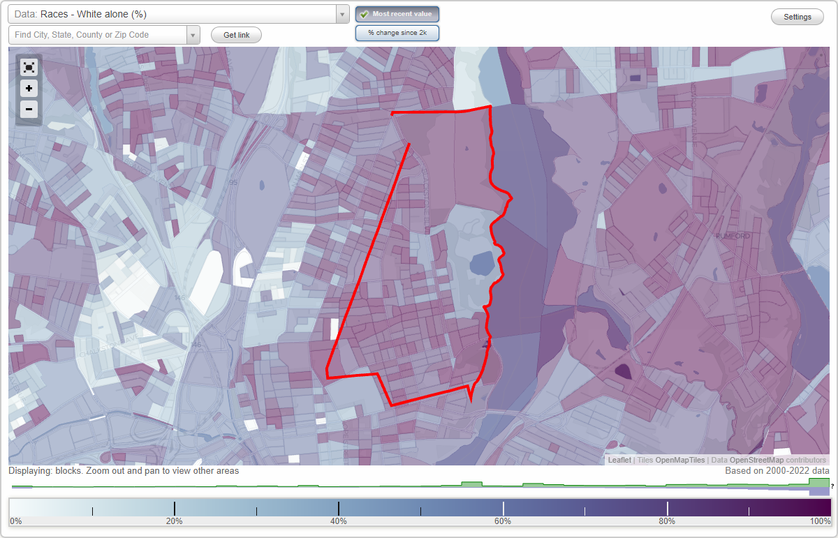
Blackstone neighborhood in Providence, Rhode Island (RI), 02906 detailed profile
Settings
X

Business Search - 14 Million verified businesses
Area: 1.442 square miles
Population: 7,014
Population density:
| Blackstone: | 4,863 people per square mile |
| Providence: | 10,266 people per square mile |

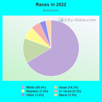
- 5,48466.4%White
- 1,18514.3%Asian
- 5967.2%Hispanic or Latino
- 4405.3%Two or more races
- 3003.6%Some other race
- 2543.1%Black
- 60.07%American Indian
Distribution of median household income
![Distribution of median household income]()
- 263Less than $10,000
- 412$10,000 to $19,999
- 496$20,000 to $29,999
- 356$30,000 to $39,999
- 476$40,000 to $49,999
- 193$50,000 to $59,999
- 157$60,000 to $74,999
- 394$75,000 to $99,999
- 251$100,000 to $124,999
- 310$125,000 to $149,999
- 447$150,000 to $199,999
- 1,019$200,000 or more

Distribution of owner-occupied house/condo value
![Distribution of owner-occupied house/condo value]()
- 296Less than $50,000
- 473$50,000 to $99,999
- 257$100,000 to $149,999
- 89$150,000 to $199,999
- 80$200,000 to $249,999
- 536$250,000 to $299,999
- 327$300,000 to $399,999
- 200$400,000 to $499,999
- 476$500,000 to $749,999
- 464$750,000 to $999,999
- 939$1,000,000 or more

Distribution of rent paid by renters
![Distribution of rent paid by renters]()
- 139Less than $100
- 640$100 to $199
- 161$200 to $299
- 490$300 to $399
- 552$400 to $499
- 302$500 to $599
- 564$700 to $799
- 219$800 to $899
- 91$900 to $999
- 369$1,000 to $1,249
- 250$1,250 to $1,499
- 656$1,500 to $1,999
- 1,697$2,000 or more

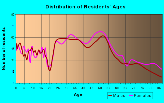
| Males: | 3,461 |
| Females: | 3,553 |
Males:
| This neighborhood: | 38.5 years |
| Whole city: | 32.9 years |
| This neighborhood: | 44.5 years |
| Whole city: | 32.4 years |
Average household size:
| Blackstone: | 5.0 people |
| Providence: | 2.4 people |
Percentage of family households:
| Blackstone: | 44.2% |
| Providence: | 37.9% |
| Here: | 55.9% |
| Providence: | 27.6% |
Percentage of married-couple families with children (among all households):
| Blackstone: | 39.2% |
| Providence: | 17.7% |
Percentage of single-mother households (among all households):
| Blackstone: | 4.5% |
| Providence: | 10.3% |
Percentage of never married males 15 years old and over:
Percentage of never married females 15 years old and over:
| Blackstone: | 13.8% |
| Providence: | 26.8% |
Percentage of never married females 15 years old and over:
| Blackstone: | 14.8% |
| city: | 28.2% |
Percentage of people that speak English not well or not at all:
| Blackstone: | 1.2% |
| Providence: | 11.5% |
Percentage of people born in this state:
Percentage of people born in another U.S. state:
Percentage of native residents but born outside the U.S.:
Percentage of foreign born residents:
| Here: | 31.3% |
| Providence: | 30.5% |
Percentage of people born in another U.S. state:
| Blackstone: | 52.9% |
| Providence: | 31.3% |
Percentage of native residents but born outside the U.S.:
| Here: | 2.3% |
| city: | 4.9% |
Percentage of foreign born residents:
| Here: | 13.6% |
| Providence: | 33.4% |
Owner-occupied
Renter-occupied

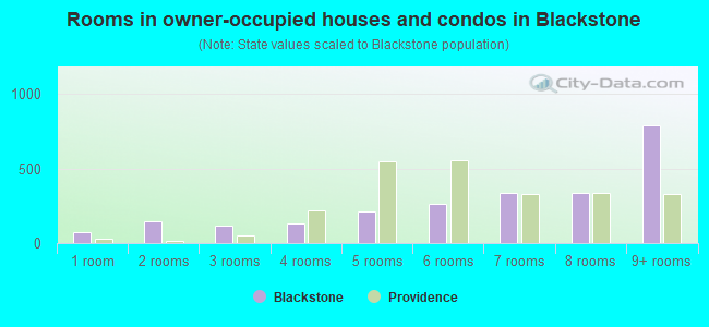
- Rooms in owner-occupied houses and condos in Blackstone
- 741 room
- 1492 rooms
- 1153 rooms
- 1344 rooms
- 2105 rooms
- 2626 rooms
- 3397 rooms
- 3348 rooms
- 7919+ rooms
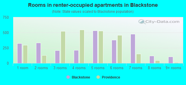
- Rooms in renter-occupied apartments in Blackstone
- 3261 room
- 3342 rooms
- 2103 rooms
- 2154 rooms
- 5315 rooms
- 3786 rooms
- 4777 rooms
- 1218 rooms
- 1059+ rooms
Owner-occupied
Renter-occupied
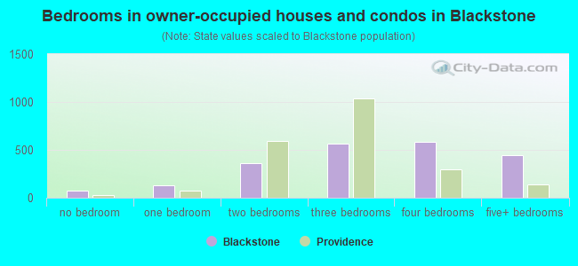
- Bedrooms in owner-occupied houses and condos in Blackstone
- 74no bedroom
- 1321 bedroom
- 3652 bedrooms
- 5693 bedrooms
- 5874 bedrooms
- 4425+ bedrooms
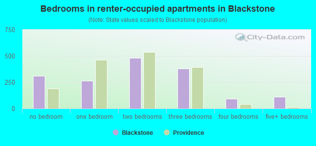
- Bedrooms in renter-occupied apartments in Blackstone
- 311no bedroom
- 2631 bedroom
- 4812 bedrooms
- 3813 bedrooms
- 924 bedrooms
- 1105+ bedrooms
Average number of cars or other vehicles available in houses/condos:
Average number of cars or other vehicles available in apartments:
| This neighborhood: | 3.5 |
| Providence: | 1.8 |
Average number of cars or other vehicles available in apartments:
| Here: | 3.7 |
| city: | 1.0 |
Percentage of units with a mortgage:
| Blackstone: | 58.0% |
| Providence: | 69.1% |
Average estimated value of detached houses in 2022 (52.4% of all units):
| Blackstone: | $1,025,049 |
| Rhode Island: | $428,590 |
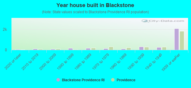
- Year house built in Blackstone
- 472020 or later
- 1012010 to 2019
- 932000 to 2009
- 1721990 to 1999
- 1651980 to 1989
- 1291970 to 1979
- 1141960 to 1969
- 3061950 to 1959
- 2461940 to 1949
- 2,0751939 or earlier
City-data.com crime index for city in 2020 (higher means more crime):
| City: | 265.3 |
| U.S. average: | 219.5 |
Travel time to work (commute)
![Travel time to work (commute)]()
- 67Less than 5 minutes
- 3485 to 9 minutes
- 59810 to 14 minutes
- 49515 to 19 minutes
- 42820 to 24 minutes
- 13725 to 29 minutes
- 17030 to 34 minutes
- 27635 to 39 minutes
- 8940 to 44 minutes
- 42845 to 59 minutes
- 11860 to 89 minutes
- 12390 or more minutes

Means of transportation to work
![Means of transportation to work]()
- 52.9%1,969Drove a car alone
- 8.9%331Carpooled
- 3.9%144Bus
- 3.7%138Long-distance train or commuter rail
- 9.2%344Ferryboat
- 4.7%176Bicycle
- 4.5%169Walked
- 10.9%405Other means
- 28.4%1,057Worked at home

Time leaving home to go to work
![Time leaving home to go to work]()
- 8912:00 a.m. to 4:59 a.m.
- 415:00 a.m. to 5:29 a.m.
- 2915:30 a.m. to 5:59 a.m.
- 686:00 a.m. to 6:29 a.m.
- 1976:30 a.m. to 6:59 a.m.
- 3937:00 a.m. to 7:29 a.m.
- 3747:30 a.m. to 7:59 a.m.
- 5948:00 a.m. to 8:29 a.m.
- 4018:30 a.m. to 8:59 a.m.
- 2989:00 a.m. to 9:59 a.m.
- 14710:00 a.m. to 10:59 a.m.
- 36411:00 a.m. to 11:59 a.m.
- 14012:00 p.m. to 3:59 p.m.
- 2284:00 p.m. to 11:59 p.m.

Occupations of males:
- Percentage of males in management occupations (except farmers):
Here: 25.0% city: 8.8%
- Percentage of males in business and financial operations occupations:
Here: 10.7% city: 3.9%
- Percentage of males in computer and mathematical occupations:
Here: 3.8% city: 4.7%
- Percentage of males in architecture and engineering occupations:
Here: 2.5% city: 2.5%
- Percentage of males in life, physical, and social science occupations:
Here: 3.3% city: 1.4%
- Percentage of males in community and social services occupations:
Here: 1.1% city: 2.2%
- Percentage of males in legal occupations:
Here: 5.5% city: 0.9%
- Percentage of males in education, training, and library occupations:
Here: 14.8% city: 7.3%
- Percentage of males in arts, design, entertainment, sports, and media occupations:
Here: 4.4% city: 3.0%
- Percentage of males in healthcare practitioners and technical occupations:
Here: 10.2% city: 4.3%
- Percentage of males in service occupations:
Here: 2.4% city: 15.1%
- Percentage of males in sales and office occupations:
Here: 8.0% city: 14.9%
- Percentage of males in construction, extraction, and maintenance occupations:
Here: 3.8% city: 6.4%
- Percentage of males in production occupations:
Here: 1.7% city: 8.8%
- Percentage of males in material moving occupations:
Here: 1.9% city: 5.1%
Occupations of females:
- Percentage of females in management occupations (except farmers):
Here: 15.1% city: 8.1%
- Percentage of females in business and financial operations occupations:
Here: 6.4% city: 4.1%
- Percentage of females in computer and mathematical occupations:
Here: 1.1% city: 1.5%
- Percentage of females in life, physical, and social science occupations:
Here: 5.6% city: 1.9%
- Percentage of females in community and social services occupations:
Here: 5.8% city: 2.9%
- Percentage of females in legal occupations:
Here: 2.0% city: 1.4%
- Percentage of females in education, training, and library occupations:
Here: 17.7% city: 9.3%
- Percentage of females in arts, design, entertainment, sports, and media occupations:
Here: 9.0% city: 3.3%
- Percentage of females in healthcare practitioners and technical occupations:
Here: 10.9% city: 7.1%
- Percentage of females in service occupations:
Here: 9.6% city: 26.3%
- Percentage of females in sales and office occupations:
Here: 12.1% city: 21.8%
- Percentage of females in production occupations:
Here: 1.3% city: 5.4%
- Percentage of females in transportation occupations:
Here: 2.1% city: 0.9%
Percentage of people 16-64 in Armed Forces:
| Blackstone: | 0.3% |
| Providence: | 0.1% |
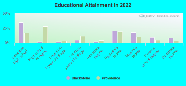
Education in this neighborhood (subdivision or community):
- Percentage of people 3 years and older in K-12 schools:
Blackstone: 25.2% Providence: 17.2%
- Percentage of people 3 years and older in undergraduate colleges:
Blackstone: 4.3% Providence: 11.1%
- Percentage of people 3 years and older in grad. or professional schools:
Blackstone: 8.8% Providence: 3.3%
- Percentage of students K-12 enrolled in private schools:
Blackstone: 64.1% Providence: 13.0%
Percentage of population below poverty level:
| Blackstone: | 5.4% |
| Providence: | 21.0% |
Median year owner moved in (as recorded in 2022):
| Blackstone: | 2008 |
| Providence: | 2010 |
Percentage of married-couple families with both working:
| Blackstone: | 114.9% |
| Providence: | 66.2% |
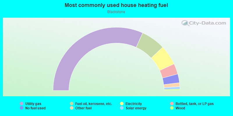
- 63.5%Utility gas
- 12.4%Fuel oil, kerosene, etc.
- 10.2%Electricity
- 5.4%Bottled, tank, or LP gas
- 4.5%No fuel used
- 2.0%Other fuel
- 1.3%Solar energy
- 0.6%Wood
Roads and streets:
Blackstone Blvd
Length: 3.24 miles
Directions: N-S, SE-NW
Address range: 18 to 670
Directions: N-S, SE-NW
Address range: 18 to 670
Elmgrove Ave
Length: 1.48 miles
Directions: E-W, N-S, SW-NE
Address range: 95 to 778
Directions: E-W, N-S, SW-NE
Address range: 95 to 778
Cole Ave
Length: 1.21 miles
Direction: N-S
Address range: 1 to 564
Direction: N-S
Address range: 1 to 564
Freeman Pkwy
Length: 0.96 miles
Direction: E-W
Address range: 1 to 349
Direction: E-W
Address range: 1 to 349
Laurel Ave
Length: 0.94 miles
Directions: E-W, SW-NE
Address range: 1 to 499
Directions: E-W, SW-NE
Address range: 1 to 499
Irving Ave
Length: 0.92 miles
Directions: E-W, SW-NE
Address range: 36 to 297
Directions: E-W, SW-NE
Address range: 36 to 297
President Ave
Length: 0.91 miles
Direction: E-W
Address range: 34 to 399
Direction: E-W
Address range: 34 to 399
Slater Ave
Length: 0.89 miles
Directions: E-W, N-S, SE-NW, SW-NE
Address range: 1 to 7386
Directions: E-W, N-S, SE-NW, SW-NE
Address range: 1 to 7386
Butler Dr
Length: 0.88 miles
Directions: E-W, N-S, SE-NW, SW-NE
Address range: 1 to 999
Directions: E-W, N-S, SE-NW, SW-NE
Address range: 1 to 999
Morris Ave
Length: 0.87 miles
Directions: N-S, SW-NE
Address range: 1 to 525
Directions: N-S, SW-NE
Address range: 1 to 525
Grotto Ave
Length: 0.77 miles
Directions: N-S, SE-NW
Address range: 1 to 423
Directions: N-S, SE-NW
Address range: 1 to 423
Lloyd Ave
Length: 0.64 miles
Direction: E-W
Address range: 354 to 572
Direction: E-W
Address range: 354 to 572
Taber Ave
Length: 0.63 miles
Directions: N-S, SE-NW, SW-NE
Address range: 102 to 371
Directions: N-S, SE-NW, SW-NE
Address range: 102 to 371
Wayland Ave
Length: 0.58 miles
Directions: N-S, SE-NW
Address range: 315 to 586
Directions: N-S, SE-NW
Address range: 315 to 586
Upton Ave
Length: 0.58 miles
Direction: E-W
Address range: 1 to 200
Direction: E-W
Address range: 1 to 200
Rochambeau Ave
Length: 0.58 miles
Directions: E-W, SE-NW
Address range: 263 to 480
Directions: E-W, SE-NW
Address range: 263 to 480
Sessions St
Length: 0.56 miles
Direction: E-W
Address range: 1 to 216
Direction: E-W
Address range: 1 to 216
Lorimer Ave
Length: 0.56 miles
Direction: SW-NE
Address range: 1 to 222
Direction: SW-NE
Address range: 1 to 222
University Ave
Length: 0.55 miles
Direction: E-W
Address range: 32 to 235
Direction: E-W
Address range: 32 to 235
Emeline St
Length: 0.48 miles
Directions: E-W, SE-NW
Address range: 1 to 173
Directions: E-W, SE-NW
Address range: 1 to 173
Ray Dr
Length: 0.41 miles
Directions: E-W, N-S, SE-NW, SW-NE
Address range: 1 to 899
Directions: E-W, N-S, SE-NW, SW-NE
Address range: 1 to 899
Woodbury St
Length: 0.41 miles
Direction: E-W
Address range: 1 to 161
Direction: E-W
Address range: 1 to 161
Hazard Ave
Length: 0.40 miles
Direction: E-W
Address range: 1 to 148
Direction: E-W
Address range: 1 to 148
Doyle Ave
Length: 0.38 miles
Direction: E-W
Address range: 244 to 360
Direction: E-W
Address range: 244 to 360
Fosdyke St
Length: 0.37 miles
Directions: E-W, N-S, SE-NW
Address range: 1 to 152
Directions: E-W, N-S, SE-NW
Address range: 1 to 152
Everett Ave
Length: 0.37 miles
Direction: E-W
Address range: 51 to 199
Direction: E-W
Address range: 51 to 199
Lincoln Ave
Length: 0.35 miles
Direction: E-W
Address range: 1 to 131
Direction: E-W
Address range: 1 to 131
Loring Ave
Length: 0.33 miles
Directions: E-W, N-S, SE-NW
Address range: 1 to 146
Directions: E-W, N-S, SE-NW
Address range: 1 to 146
Duncan Dr
Length: 0.33 miles
Directions: E-W, N-S, SE-NW
Address range: 1 to 399
Directions: E-W, N-S, SE-NW
Address range: 1 to 399
Gulf Ave
Length: 0.32 miles
Directions: E-W, N-S, SE-NW, SW-NE
Address range: 1 to 99
Directions: E-W, N-S, SE-NW, SW-NE
Address range: 1 to 99
Mount Ave
Length: 0.32 miles
Direction: E-W
Address range: 1 to 111
Direction: E-W
Address range: 1 to 111
Intervale Rd
Length: 0.31 miles
Direction: E-W
Address range: 1 to 99
Direction: E-W
Address range: 1 to 99
Clarendon Ave
Length: 0.28 miles
Direction: E-W
Address range: 1 to 118
Direction: E-W
Address range: 1 to 118
Olney St
Length: 0.28 miles
Direction: E-W
Address range: 272 to 385
Direction: E-W
Address range: 272 to 385
Swan Point Rd
Length: 0.28 miles
Directions: E-W, SW-NE
Address range: 1 to 99
Directions: E-W, SW-NE
Address range: 1 to 99
Westford Rd
Length: 0.28 miles
Direction: E-W
Address range: 1 to 80
Direction: E-W
Address range: 1 to 80
Wingate Rd
Length: 0.24 miles
Direction: E-W
Address range: 1 to 99
Direction: E-W
Address range: 1 to 99
Savoy St
Length: 0.24 miles
Direction: E-W
Address range: 32 to 136
Direction: E-W
Address range: 32 to 136
Sargent Ave
Length: 0.24 miles
Direction: E-W
Address range: 1 to 84
Direction: E-W
Address range: 1 to 84
Vassar Ave
Length: 0.23 miles
Direction: E-W
Address range: 1 to 98
Direction: E-W
Address range: 1 to 98
Alumni Ave
Length: 0.23 miles
Directions: E-W, SW-NE
Address range: 11 to 118
Directions: E-W, SW-NE
Address range: 11 to 118
Taft Ave
Length: 0.22 miles
Directions: N-S, SW-NE
Address range: 1 to 110
Directions: N-S, SW-NE
Address range: 1 to 110
Harwich Rd
Length: 0.22 miles
Direction: E-W
Address range: 1 to 81
Direction: E-W
Address range: 1 to 81
Lorraine Ave
Length: 0.21 miles
Direction: N-S
Address range: 1 to 107
Direction: N-S
Address range: 1 to 107
Winfield Rd
Length: 0.21 miles
Directions: E-W, N-S, SE-NW, SW-NE
Address range: 1 to 63
Directions: E-W, N-S, SE-NW, SW-NE
Address range: 1 to 63
Faunce Dr
Length: 0.20 miles
Directions: E-W, N-S, SW-NE
Address range: 1 to 99
Directions: E-W, N-S, SW-NE
Address range: 1 to 99
Hartshorne Rd
Length: 0.20 miles
Directions: E-W, SE-NW
Address range: 65 to 146
Directions: E-W, SE-NW
Address range: 65 to 146
Brookway Rd
Length: 0.19 miles
Directions: E-W, N-S, SW-NE
Address range: 1 to 99
Directions: E-W, N-S, SW-NE
Address range: 1 to 99
Woodland Ter
Length: 0.18 miles
Directions: E-W, N-S, SE-NW
Address range: 1 to 33
Directions: E-W, N-S, SE-NW
Address range: 1 to 33
Holly St
Length: 0.18 miles
Directions: N-S, SW-NE
Address range: 1 to 99
Directions: N-S, SW-NE
Address range: 1 to 99
Alton Rd
Length: 0.17 miles
Directions: E-W, N-S, SE-NW, SW-NE
Address range: 1 to 99
Directions: E-W, N-S, SE-NW, SW-NE
Address range: 1 to 99
Channing Ave
Length: 0.16 miles
Direction: E-W
Address range: 1 to 66
Direction: E-W
Address range: 1 to 66
Belair Ave
Length: 0.15 miles
Direction: SW-NE
Address range: 1 to 66
Direction: SW-NE
Address range: 1 to 66
Magellan St
Length: 0.15 miles
Direction: E-W
Address range: 1 to 54
Direction: E-W
Address range: 1 to 54
Eames St
Length: 0.15 miles
Direction: E-W
Address range: 1 to 60
Direction: E-W
Address range: 1 to 60
Arlington Ave
Length: 0.14 miles
Directions: N-S, SE-NW
Address range: 175 to 252
Directions: N-S, SE-NW
Address range: 175 to 252
Brenton Ave
Length: 0.14 miles
Direction: N-S
Address range: 1 to 77
Direction: N-S
Address range: 1 to 77
Old Tannery Rd
Length: 0.14 miles
Directions: E-W, SW-NE
Address range: 1 to 45
Directions: E-W, SW-NE
Address range: 1 to 45
Luzon Ave
Length: 0.14 miles
Direction: E-W
Address range: 1 to 49
Direction: E-W
Address range: 1 to 49
Boylston Ave
Length: 0.14 miles
Direction: N-S
Address range: 1 to 78
Direction: N-S
Address range: 1 to 78
Barberry Hill
Length: 0.14 miles
Directions: E-W, N-S, SW-NE
Address range: 1 to 62
Directions: E-W, N-S, SW-NE
Address range: 1 to 62
Montague St
Length: 0.13 miles
Direction: E-W
Address range: 19 to 60
Direction: E-W
Address range: 19 to 60
4th St
Length: 0.12 miles
Directions: E-W, SE-NW
Address range: 256 to 279
Directions: E-W, SE-NW
Address range: 256 to 279
Glen Dr
Length: 0.12 miles
Directions: N-S, SE-NW
Address range: 1 to 51
Directions: N-S, SE-NW
Address range: 1 to 51
Wriston Dr
Length: 0.12 miles
Direction: E-W
Address range: 1 to 56
Direction: E-W
Address range: 1 to 56
Elmway St
Length: 0.12 miles
Directions: E-W, N-S
Address range: 1 to 51
Directions: E-W, N-S
Address range: 1 to 51
Doane Ave
Length: 0.12 miles
Direction: E-W
Address range: 1 to 99
Direction: E-W
Address range: 1 to 99
Balton Rd
Length: 0.11 miles
Direction: N-S
Address range: 1 to 64
Direction: N-S
Address range: 1 to 64
Burlington St
Length: 0.11 miles
Direction: E-W
Address range: 91 to 142
Direction: E-W
Address range: 91 to 142
Stadium Rd
Length: 0.11 miles
Directions: E-W, N-S, SE-NW
Address range: 1 to 65
Directions: E-W, N-S, SE-NW
Address range: 1 to 65
Barbour Dr
Length: 0.10 miles
Direction: N-S
Address range: 1 to 59
Direction: N-S
Address range: 1 to 59
Cole Farm Ct
Length: 0.10 miles
Directions: E-W, SE-NW, SW-NE
Address range: 1 to 33
Directions: E-W, SE-NW, SW-NE
Address range: 1 to 33
Butler Hospital
Length: 0.10 miles
Directions: E-W, N-S, SW-NE
Address range: 19 to 32
Directions: E-W, N-S, SW-NE
Address range: 19 to 32
Margrave Ave
Length: 0.09 miles
Direction: E-W
Address range: 1 to 35
Direction: E-W
Address range: 1 to 35
Bevelin Rd
Length: 0.08 miles
Direction: E-W
Address range: 1 to 38
Direction: E-W
Address range: 1 to 38
Harian Rd
Length: 0.08 miles
Direction: E-W
Address range: 1 to 27
Direction: E-W
Address range: 1 to 27
Maxcy Dr
Length: 0.08 miles
Direction: E-W
Address range: 1 to 51
Direction: E-W
Address range: 1 to 51
Ray St
Length: 0.08 miles
Direction: E-W
Address range: 1 to 99
Direction: E-W
Address range: 1 to 99
Morrison St
Length: 0.08 miles
Direction: E-W
Address range: 1 to 34
Direction: E-W
Address range: 1 to 34
Linden Dr
Length: 0.08 miles
Direction: E-W
Address range: 1 to 38
Direction: E-W
Address range: 1 to 38
Edison Ave
Length: 0.08 miles
Directions: N-S, SE-NW
Address range: 1 to 33
Directions: N-S, SE-NW
Address range: 1 to 33
Miles Ave
Length: 0.08 miles
Direction: N-S
Address range: 1 to 99
Direction: N-S
Address range: 1 to 99
Hobart Ave
Length: 0.08 miles
Direction: N-S
Address range: 1 to 50
Direction: N-S
Address range: 1 to 50
Rose Ct
Length: 0.08 miles
Directions: N-S, SE-NW
Address range: 1 to 29
Directions: N-S, SE-NW
Address range: 1 to 29
Astral Ave
Length: 0.08 miles
Direction: N-S
Address range: 1 to 48
Direction: N-S
Address range: 1 to 48
Kingston Ave
Length: 0.08 miles
Direction: N-S
Address range: 1 to 50
Direction: N-S
Address range: 1 to 50
Gorton St
Length: 0.07 miles
Direction: E-W
Address range: 1 to 29
Direction: E-W
Address range: 1 to 29
Laurel Ct
Length: 0.07 miles
Directions: N-S, SE-NW
Address range: 1 to 40
Directions: N-S, SE-NW
Address range: 1 to 40
Abbottsford Ct
Length: 0.07 miles
Direction: N-S
Address range: 1 to 36
Direction: N-S
Address range: 1 to 36
Phillips St
Length: 0.07 miles
Direction: E-W
Address range: 23 to 43
Direction: E-W
Address range: 23 to 43
Weymouth St
Length: 0.06 miles
Direction: SE-NW
Address range: 62 to 99
Direction: SE-NW
Address range: 62 to 99
Ruthven St
Length: 0.06 miles
Direction: E-W
Address range: 1 to 30
Direction: E-W
Address range: 1 to 30
Lauriston St
Length: 0.06 miles
Direction: E-W
Address range: 130 to 146
Direction: E-W
Address range: 130 to 146
Goldsmith St
Length: 0.06 miles
Direction: E-W
Address range: 1 to 25
Direction: E-W
Address range: 1 to 25
Cypress St
Length: 0.06 miles
Direction: E-W
Address range: 255 to 267
Direction: E-W
Address range: 255 to 267
Mutual Pl
Length: 0.06 miles
Direction: N-S
Address range: 1 to 34
Direction: N-S
Address range: 1 to 34
8th St
Length: 0.06 miles
Direction: E-W
Direction: E-W
Larch St
Length: 0.05 miles
Direction: E-W
Address range: 125 to 172
Direction: E-W
Address range: 125 to 172
5th St
Length: 0.05 miles
Direction: E-W
Address range: 246 to 270
Direction: E-W
Address range: 246 to 270
Penrose Ave
Length: 0.05 miles
Direction: E-W
Address range: 1 to 29
Direction: E-W
Address range: 1 to 29
Winfield Ct
Length: 0.04 miles
Direction: SE-NW
Address range: 1 to 36
Direction: SE-NW
Address range: 1 to 36
Aldrich Ter
Length: 0.04 miles
Direction: SW-NE
Address range: 1 to 43
Direction: SW-NE
Address range: 1 to 43
North Ave
Length: 0.03 miles
Direction: E-W
Direction: E-W