Bonner Loring neighborhood in Bonner Springs, Kansas (KS), 66111, 66012 detailed profile
Settings
X


Business Search - 14 Million verified businesses
Area: 20.393 square miles
Population: 27,951
Population density:
| Bonner Loring: | 1,371 people per square mile |
| Bonner Springs: | 493 people per square mile |

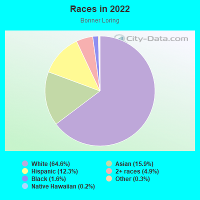
- 19,71264.6%White
- 4,84915.9%Asian
- 3,76412.3%Hispanic or Latino
- 1,4994.9%Two or more races
- 5031.6%Black
- 970.3%Some other race
- 570.2%Native Hawaiian and Other
Pacific Islander - 130.04%American Indian
Distribution of median household income
![Distribution of median household income]()
- 333Less than $10,000
- 1,270$10,000 to $19,999
- 584$20,000 to $29,999
- 1,690$30,000 to $39,999
- 921$40,000 to $49,999
- 782$50,000 to $59,999
- 1,024$60,000 to $74,999
- 1,752$75,000 to $99,999
- 1,127$100,000 to $124,999
- 538$125,000 to $149,999
- 1,135$150,000 to $199,999
- 1,557$200,000 or more

Distribution of owner-occupied house/condo value
![Distribution of owner-occupied house/condo value]()
- 2,787Less than $50,000
- 3,596$50,000 to $99,999
- 1,072$100,000 to $149,999
- 1,559$150,000 to $199,999
- 1,758$200,000 to $249,999
- 599$250,000 to $299,999
- 788$300,000 to $399,999
- 40$400,000 to $499,999
- 160$500,000 to $749,999
- 5$750,000 to $999,999
- 690$1,000,000 or more

Distribution of rent paid by renters
![Distribution of rent paid by renters]()
- 5$100 to $199
- 875$200 to $299
- 336$300 to $399
- 741$400 to $499
- 627$500 to $599
- 1,481$600 to $699
- 894$700 to $799
- 201$800 to $899
- 1,134$900 to $999
- 405$1,000 to $1,249
- 1,329$1,250 to $1,499
- 9$1,500 to $1,999
- 618$2,000 or more

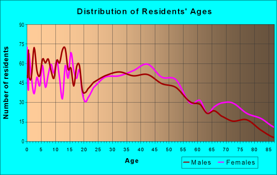
| Males: | 14,494 |
| Females: | 13,457 |
Males:
| This neighborhood: | |
| Whole city: |
| This neighborhood: | |
| Whole city: |
Percentage of family households:
| Bonner Loring: | 57.0% |
| Bonner Springs: | 58.6% |
| Here: | 59.4% |
| Bonner Springs: | 58.9% |
Percentage of married-couple families with children (among all households):
| Bonner Loring: | 27.5% |
| Bonner Springs: | 25.3% |
Percentage of single-mother households (among all households):
| Bonner Loring: | 4.7% |
| Bonner Springs: | 8.9% |
Percentage of never married males 15 years old and over:
Percentage of never married females 15 years old and over:
| Bonner Loring: | 12.7% |
| Bonner Springs: | 13.3% |
Percentage of never married females 15 years old and over:
| Bonner Loring: | 12.3% |
| city: | 12.0% |
Percentage of people that speak English not well or not at all:
| Bonner Loring: | 6.7% |
| Bonner Springs: | 3.9% |
Percentage of people born in this state:
Percentage of people born in another U.S. state:
Percentage of native residents but born outside the U.S.:
Percentage of foreign born residents:
| Here: | 59.6% |
| Bonner Springs: | 60.7% |
Percentage of people born in another U.S. state:
| Bonner Loring: | 28.5% |
| Bonner Springs: | 30.1% |
Percentage of native residents but born outside the U.S.:
| Here: | 1.8% |
| city: | 1.3% |
Percentage of foreign born residents:
| Here: | 10.1% |
| Bonner Springs: | 8.0% |
Owner-occupied
Renter-occupied

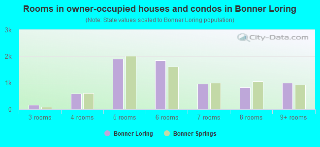
- Rooms in owner-occupied houses and condos in Bonner Loring
- 01 room
- 02 rooms
- 1733 rooms
- 5894 rooms
- 1,9155 rooms
- 1,8536 rooms
- 9547 rooms
- 8358 rooms
- 9989+ rooms
- Rooms in renter-occupied apartments in Bonner Loring
- 1191 room
- 3832 rooms
- 4533 rooms
- 7834 rooms
- 7695 rooms
- 1,3116 rooms
- 4727 rooms
- 8478 rooms
- 8409+ rooms
Owner-occupied
Renter-occupied

- Bedrooms in owner-occupied houses and condos in Bonner Loring
- 0no bedroom
- 4391 bedroom
- 1,4042 bedrooms
- 3,6913 bedrooms
- 9874 bedrooms
- 8085+ bedrooms
- Bedrooms in renter-occupied apartments in Bonner Loring
- 119no bedroom
- 5281 bedroom
- 9522 bedrooms
- 2,0913 bedrooms
- 8724 bedrooms
- 2,0875+ bedrooms
Average number of cars or other vehicles available in houses/condos:
Average number of cars or other vehicles available in apartments:
| This neighborhood: | |
| Bonner Springs: |
Average number of cars or other vehicles available in apartments:
| Here: | |
| city: |
Percentage of units with a mortgage:
| Bonner Loring: | 60.7% |
| Bonner Springs: | 60.1% |
- Year house built in Bonner Loring
- 812020 or later
- 7292010 to 2019
- 1,7122000 to 2009
- 8681990 to 1999
- 8901980 to 1989
- 1,3911970 to 1979
- 1,6221960 to 1969
- 1,0971950 to 1959
- 9841940 to 1949
- 1,9621939 or earlier
City-data.com crime index for city in 2020 (higher means more crime):
| City: | 70.1 |
| U.S. average: | 219.5 |
Travel time to work (commute)
![Travel time to work (commute)]()
- 586Less than 5 minutes
- 2,3455 to 9 minutes
- 1,30810 to 14 minutes
- 2,57015 to 19 minutes
- 1,69020 to 24 minutes
- 2,05325 to 29 minutes
- 2,22630 to 34 minutes
- 42735 to 39 minutes
- 87140 to 44 minutes
- 18445 to 59 minutes
- 12660 to 89 minutes
- 47890 or more minutes

Means of transportation to work
![Means of transportation to work]()
- 79.7%9,827Drove a car alone
- 10.5%1,290Carpooled
- 0.9%109Ferryboat
- 1.5%189Motorcycle
- 1.6%203Walked
- 2.3%288Other means
- 7.6%936Worked at home

Time leaving home to go to work
![Time leaving home to go to work]()
- 47512:00 a.m. to 4:59 a.m.
- 1,2795:00 a.m. to 5:29 a.m.
- 1,0885:30 a.m. to 5:59 a.m.
- 2,2076:00 a.m. to 6:29 a.m.
- 1,0006:30 a.m. to 6:59 a.m.
- 2,5277:00 a.m. to 7:29 a.m.
- 1,7347:30 a.m. to 7:59 a.m.
- 1,3538:00 a.m. to 8:29 a.m.
- 2938:30 a.m. to 8:59 a.m.
- 5979:00 a.m. to 9:59 a.m.
- 37910:00 a.m. to 10:59 a.m.
- 8311:00 a.m. to 11:59 a.m.
- 61112:00 p.m. to 3:59 p.m.
- 1,0494:00 p.m. to 11:59 p.m.

Occupations of males:
- Percentage of males in management occupations (except farmers):
Here: 9.1% city: 15.4%
- Percentage of males in computer and mathematical occupations:
Here: 3.7% city: 2.9%
- Percentage of males in education, training, and library occupations:
Here: 4.7% city: 3.1%
- Percentage of males in arts, design, entertainment, sports, and media occupations:
Here: 1.9% city: 1.0%
- Percentage of males in service occupations:
Here: 20.5% city: 15.8%
- Percentage of males in sales and office occupations:
Here: 6.2% city: 10.3%
- Percentage of males in farming, fishing, and forestry occupations:
Here: 4.3% city: 1.9%
- Percentage of males in construction, extraction, and maintenance occupations:
Here: 4.1% city: 6.9%
- Percentage of males in production occupations:
Here: 26.6% city: 18.6%
- Percentage of males in transportation occupations:
Here: 3.8% city: 3.9%
- Percentage of males in material moving occupations:
Here: 5.7% city: 6.8%
Occupations of females:
- Percentage of females in management occupations (except farmers):
Here: 2.5% city: 7.2%
- Percentage of females in business and financial operations occupations:
Here: 12.4% city: 7.3%
- Percentage of females in computer and mathematical occupations:
Here: 1.0% city: 1.5%
- Percentage of females in architecture and engineering occupations:
Here: 1.9% city: 1.8%
- Percentage of females in community and social services occupations:
Here: 2.8% city: 3.2%
- Percentage of females in education, training, and library occupations:
Here: 10.8% city: 10.2%
- Percentage of females in arts, design, entertainment, sports, and media occupations:
Here: 7.0% city: 3.9%
- Percentage of females in healthcare practitioners and technical occupations:
Here: 6.3% city: 6.9%
- Percentage of females in service occupations:
Here: 22.9% city: 21.3%
- Percentage of females in sales and office occupations:
Here: 17.7% city: 24.8%
- Percentage of females in production occupations:
Here: 4.9% city: 3.5%
- Percentage of females in material moving occupations:
Here: 9.1% city: 6.0%
Percentage of people 16-64 in Armed Forces:
| Bonner Loring: | 0.2% |
| Bonner Springs: | 0.0% |
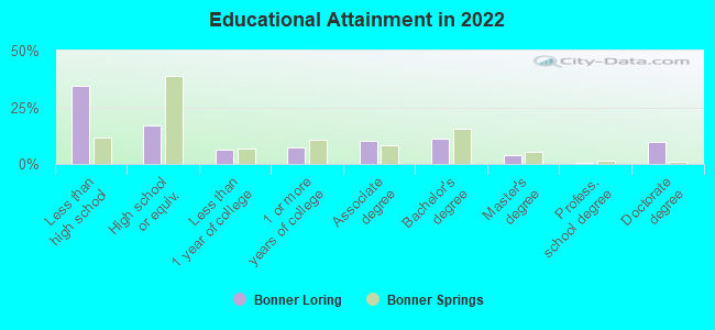
Education in this neighborhood (subdivision or community):
- Percentage of people 3 years and older in K-12 schools:
Bonner Loring: 34.0% Bonner Springs: 22.5%
- Percentage of people 3 years and older in undergraduate colleges:
Bonner Loring: 2.0% Bonner Springs: 2.5%
- Percentage of people 3 years and older in grad. or professional schools:
Bonner Loring: 1.4% Bonner Springs: 0.5%
- Percentage of students K-12 enrolled in private schools:
Bonner Loring: 7.9% Bonner Springs: 1.5%
Percentage of population below poverty level:
| Bonner Loring: | 14.6% |
| Bonner Springs: | 12.5% |
Percentage of married-couple families with both working:
| Bonner Loring: | 59.6% |
| Bonner Springs: | 63.2% |
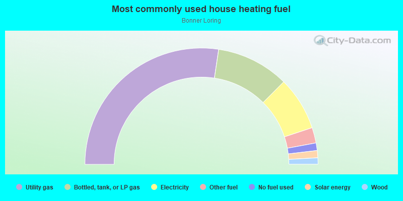
- 54.8%Utility gas
- 20.2%Bottled, tank, or LP gas
- 14.9%Electricity
- 4.3%Other fuel
- 2.1%No fuel used
- 2.0%Solar energy
- 1.8%Wood
Highways in this neighborhood:
State Hwy 7
Length: 0.06 miles
Direction: SE-NW
Direction: SE-NW
Roads and streets:
Railroad features:
at and Sf Rlwy
Length: 1.75 miles
Direction: SW-NE
Direction: SW-NE
Roads and streets:
142nd St (S 142nd St)
Length: 2.70 miles
Direction: N-S
Address range: 2671 to 14905
Direction: N-S
Address range: 2671 to 14905
Railroad features:
Other features:
Little Kaw Crk
Length: 0.00 miles
Direction: E-W
Direction: E-W
Limited-access highways (interstate or state) in this neighborhood:
Kansas Tpke (I- 70)
Length: 7.42 miles
Direction: E-W
Direction: E-W
Highways in this neighborhood:
State Hwy 7 (S 130th St)
Length: 5.11 miles
Directions: E-W, N-S, SE-NW
Address range: 1 to 2498
Directions: E-W, N-S, SE-NW
Address range: 1 to 2498
State Hwy 32 (Kaw Dr, E Front St)
Length: 4.13 miles
Directions: E-W, N-S, SW-NE
Address range: 200 to 12989
Directions: E-W, N-S, SW-NE
Address range: 200 to 12989
State Hwy 7
Length: 2.24 miles
Direction: SE-NW
Direction: SE-NW
State Hwy 32 (W Kump Ave)
Length: 1.09 miles
Direction: E-W
Address range: 100 to 699
Direction: E-W
Address range: 100 to 699
State Hwy 32 (Gibbs Rd)
Length: 0.29 miles
Direction: E-W
Address range: 13800 to 14052
Direction: E-W
Address range: 13800 to 14052
State Hwy 32 (E Cedar St)
Length: 0.22 miles
Direction: SE-NW
Address range: 100 to 299
Direction: SE-NW
Address range: 100 to 299
State Hwy 32 (E Kump Ave)
Length: 0.11 miles
Directions: E-W, SE-NW
Address range: 100 to 199
Directions: E-W, SE-NW
Address range: 100 to 199
Roads and streets:
Lake Forest Rd
Length: 4.90 miles
Directions: E-W, N-S, SE-NW, SW-NE
Address range: 1 to 910
Directions: E-W, N-S, SE-NW, SW-NE
Address range: 1 to 910
Riverview Ave
Length: 4.52 miles
Directions: E-W, N-S, SE-NW, SW-NE
Address range: 11336 to 13981
Directions: E-W, N-S, SE-NW, SW-NE
Address range: 11336 to 13981
Kansas Ave
Length: 3.93 miles
Directions: E-W, SE-NW
Address range: 11000 to 14177
Directions: E-W, SE-NW
Address range: 11000 to 14177
Wy-Co Park Rd
Length: 3.18 miles
Directions: E-W, N-S, SE-NW, SW-NE
Directions: E-W, N-S, SE-NW, SW-NE
Loring Dr (Loring Ln, W 2nd St)
Length: 2.81 miles
Directions: E-W, N-S, SW-NE
Address range: 813 to 4899
Directions: E-W, N-S, SW-NE
Address range: 813 to 4899
142nd St (S 142nd St)
Length: 2.70 miles
Direction: N-S
Address range: 2671 to 14905
Direction: N-S
Address range: 2671 to 14905
S 138 St (S 138th St)
Length: 2.01 miles
Direction: N-S
Address range: 600 to 2499
Direction: N-S
Address range: 600 to 2499
N 130th St
Length: 1.72 miles
Directions: N-S, SE-NW, SW-NE
Address range: 1 to 500
Directions: N-S, SE-NW, SW-NE
Address range: 1 to 500
Stevenson Ln (S 122 St)
Length: 1.61 miles
Directions: N-S, SE-NW, SW-NE
Address range: 1 to 1499
Directions: N-S, SE-NW, SW-NE
Address range: 1 to 1499
Metropolitan Ave
Length: 1.50 miles
Directions: E-W, SE-NW
Address range: 12080 to 13861
Directions: E-W, SE-NW
Address range: 12080 to 13861
Stillwell Rd
Length: 1.30 miles
Direction: E-W
Address range: 13400 to 14199
Direction: E-W
Address range: 13400 to 14199
S 134th St
Length: 1.27 miles
Directions: E-W, N-S, SE-NW
Address range: 1 to 1499
Directions: E-W, N-S, SE-NW
Address range: 1 to 1499
S 130 St (Metropolitan Ave, 130th St)
Length: 1.11 miles
Directions: E-W, N-S, SE-NW, SW-NE
Directions: E-W, N-S, SE-NW, SW-NE
W Morse Ave
Length: 1.10 miles
Direction: E-W
Address range: 100 to 799
Direction: E-W
Address range: 100 to 799
S 118th St
Length: 1.05 miles
Direction: N-S
Address range: 1 to 899
Direction: N-S
Address range: 1 to 899
N Nettleton Ave
Length: 1.04 miles
Directions: N-S, SE-NW, SW-NE
Address range: 100 to 899
Directions: N-S, SE-NW, SW-NE
Address range: 100 to 899
Sheidley Ave
Length: 1.00 miles
Directions: N-S, SE-NW
Address range: 100 to 999
Directions: N-S, SE-NW
Address range: 100 to 999
Archer Rd
Length: 0.99 miles
Direction: E-W
Address range: 13700 to 13999
Direction: E-W
Address range: 13700 to 13999
Allcutt Ave
Length: 0.89 miles
Directions: E-W, N-S, SE-NW, SW-NE
Address range: 100 to 835
Directions: E-W, N-S, SE-NW, SW-NE
Address range: 100 to 835
N 126 St (N 126th St)
Length: 0.83 miles
Directions: N-S, SE-NW
Address range: 1 to 975
Directions: N-S, SE-NW
Address range: 1 to 975
Pratt Ave
Length: 0.83 miles
Directions: E-W, SW-NE
Address range: 100 to 799
Directions: E-W, SW-NE
Address range: 100 to 799
N 134 St (N 134th St)
Length: 0.80 miles
Directions: N-S, SE-NW, SW-NE
Address range: 210 to 699
Directions: N-S, SE-NW, SW-NE
Address range: 210 to 699
Loring Dr (Loring Ln, W 2nd St, W 2 St)
Length: 0.78 miles
Directions: E-W, N-S, SE-NW, SW-NE
Address range: 100 to 3061
Directions: E-W, N-S, SE-NW, SW-NE
Address range: 100 to 3061
N 134th St
Length: 0.78 miles
Direction: N-S
Address range: 1 to 223
Direction: N-S
Address range: 1 to 223
Scheidt Ln
Length: 0.74 miles
Directions: E-W, N-S, SE-NW
Address range: 200 to 2599
Directions: E-W, N-S, SE-NW
Address range: 200 to 2599
Woodend Rd
Length: 0.71 miles
Directions: E-W, N-S, SW-NE
Address range: 200 to 13838
Directions: E-W, N-S, SW-NE
Address range: 200 to 13838
N 118 St (N 118th St)
Length: 0.68 miles
Directions: N-S, SW-NE
Address range: 311 to 911
Directions: N-S, SW-NE
Address range: 311 to 911
Martinek Ln
Length: 0.68 miles
Directions: N-S, SW-NE
Address range: 972 to 1399
Directions: N-S, SW-NE
Address range: 972 to 1399
Swingster Rd (S 121 St)
Length: 0.66 miles
Directions: N-S, SE-NW, SW-NE
Directions: N-S, SE-NW, SW-NE
Wy Co Park Rd
Length: 0.65 miles
Directions: E-W, N-S, SE-NW
Directions: E-W, N-S, SE-NW
Swingster Rd
Length: 0.64 miles
Direction: E-W
Direction: E-W
S Bluegrass Ave
Length: 0.60 miles
Directions: E-W, N-S, SE-NW
Address range: 300 to 581
Directions: E-W, N-S, SE-NW
Address range: 300 to 581
S 132 St (Swartz Rd)
Length: 0.59 miles
Directions: E-W, N-S, SE-NW
Address range: 800 to 13199
Directions: E-W, N-S, SE-NW
Address range: 800 to 13199
W Front St
Length: 0.58 miles
Directions: E-W, SW-NE
Address range: 100 to 899
Directions: E-W, SW-NE
Address range: 100 to 899
Emerson Ave
Length: 0.55 miles
Direction: N-S
Address range: 100 to 504
Direction: N-S
Address range: 100 to 504
Lakewood Rd
Length: 0.55 miles
Directions: N-S, SE-NW, SW-NE
Address range: 500 to 799
Directions: N-S, SE-NW, SW-NE
Address range: 500 to 799
E Morse Ave
Length: 0.54 miles
Direction: E-W
Address range: 100 to 699
Direction: E-W
Address range: 100 to 699
Kreider Rd
Length: 0.53 miles
Direction: E-W
Address range: 13900 to 13999
Direction: E-W
Address range: 13900 to 13999
N Neconi Ave
Length: 0.51 miles
Direction: N-S
Address range: 100 to 499
Direction: N-S
Address range: 100 to 499
N Garfield St
Length: 0.51 miles
Directions: N-S, SW-NE
Address range: 100 to 499
Directions: N-S, SW-NE
Address range: 100 to 499
Cornell Ave
Length: 0.50 miles
Direction: N-S
Address range: 100 to 399
Direction: N-S
Address range: 100 to 399
Linda Ln
Length: 0.49 miles
Directions: N-S, SE-NW, SW-NE
Address range: 500 to 755
Directions: N-S, SE-NW, SW-NE
Address range: 500 to 755
Morse Ave (W Morse Ave)
Length: 0.49 miles
Directions: E-W, SE-NW
Directions: E-W, SE-NW
W Insley Ave
Length: 0.48 miles
Direction: E-W
Address range: 100 to 599
Direction: E-W
Address range: 100 to 599
E Spring Ave
Length: 0.48 miles
Directions: E-W, SE-NW
Address range: 100 to 699
Directions: E-W, SE-NW
Address range: 100 to 699
S 130th (S 130th St)
Length: 0.45 miles
Directions: E-W, N-S, SE-NW, SW-NE
Address range: 115 to 121
Directions: E-W, N-S, SE-NW, SW-NE
Address range: 115 to 121
Grove Ave
Length: 0.45 miles
Directions: E-W, SW-NE
Address range: 100 to 13999
Directions: E-W, SW-NE
Address range: 100 to 13999
Arthur Ave
Length: 0.43 miles
Directions: N-S, SE-NW
Address range: 100 to 499
Directions: N-S, SE-NW
Address range: 100 to 499
N 130 St (N 130th St)
Length: 0.43 miles
Directions: E-W, N-S, SW-NE
Address range: 441 to 810
Directions: E-W, N-S, SW-NE
Address range: 441 to 810
N Bluegrass Dr
Length: 0.43 miles
Directions: N-S, SE-NW
Address range: 300 to 599
Directions: N-S, SE-NW
Address range: 300 to 599
Clark Ave
Length: 0.42 miles
Direction: N-S
Address range: 100 to 499
Direction: N-S
Address range: 100 to 499
Highview Ave
Length: 0.41 miles
Direction: E-W
Address range: 101 to 359
Direction: E-W
Address range: 101 to 359
Richland Ave
Length: 0.41 miles
Directions: E-W, N-S, SE-NW
Address range: 13100 to 13199
Directions: E-W, N-S, SE-NW
Address range: 13100 to 13199
Tom Lally Dr
Length: 0.41 miles
Directions: E-W, N-S, SE-NW, SW-NE
Directions: E-W, N-S, SE-NW, SW-NE
Lake Forest Dr
Length: 0.39 miles
Directions: E-W, N-S, SE-NW, SW-NE
Directions: E-W, N-S, SE-NW, SW-NE
Murphy Ave
Length: 0.38 miles
Direction: E-W
Address range: 300 to 799
Direction: E-W
Address range: 300 to 799
S 137 St (S 137th St)
Length: 0.38 miles
Direction: N-S
Address range: 1400 to 1839
Direction: N-S
Address range: 1400 to 1839
Ashwood Ln
Length: 0.37 miles
Directions: E-W, N-S, SE-NW, SW-NE
Address range: 1 to 99
Directions: E-W, N-S, SE-NW, SW-NE
Address range: 1 to 99
Armour Ave
Length: 0.37 miles
Direction: N-S
Address range: 100 to 350
Direction: N-S
Address range: 100 to 350
Bonner Ln
Length: 0.36 miles
Direction: SW-NE
Address range: 900 to 1499
Direction: SW-NE
Address range: 900 to 1499
N 118th St
Length: 0.35 miles
Direction: N-S
Address range: 1 to 332
Direction: N-S
Address range: 1 to 332
Macgrantwood St
Length: 0.35 miles
Directions: E-W, N-S, SE-NW, SW-NE
Address range: 500 to 699
Directions: E-W, N-S, SE-NW, SW-NE
Address range: 500 to 699
Warner Ave
Length: 0.34 miles
Directions: N-S, SE-NW
Address range: 100 to 399
Directions: N-S, SE-NW
Address range: 100 to 399
Heritage Dr
Length: 0.33 miles
Direction: E-W
Address range: 13100 to 13599
Direction: E-W
Address range: 13100 to 13599
S 110 St (S 110th St)
Length: 0.33 miles
Direction: N-S
Address range: 380 to 999
Direction: N-S
Address range: 380 to 999
Lilac Ln
Length: 0.33 miles
Directions: E-W, SE-NW, SW-NE
Address range: 23 to 85
Directions: E-W, SE-NW, SW-NE
Address range: 23 to 85
Stephan Ave
Length: 0.33 miles
Directions: E-W, N-S, SE-NW
Address range: 500 to 536
Directions: E-W, N-S, SE-NW
Address range: 500 to 536
Commercial Dr
Length: 0.32 miles
Directions: E-W, N-S, SW-NE
Address range: 500 to 599
Directions: E-W, N-S, SW-NE
Address range: 500 to 599
Lawrence Ave
Length: 0.32 miles
Direction: E-W
Address range: 13600 to 13799
Direction: E-W
Address range: 13600 to 13799
Martin Luther King Ave (Martin Luther King Jr Ave)
Length: 0.32 miles
Direction: E-W
Address range: 13600 to 13799
Direction: E-W
Address range: 13600 to 13799
Springdale Ave
Length: 0.32 miles
Direction: E-W
Address range: 200 to 399
Direction: E-W
Address range: 200 to 399
Pioneer Dr
Length: 0.31 miles
Direction: E-W
Address range: 13344 to 13545
Direction: E-W
Address range: 13344 to 13545
Willard Ave
Length: 0.30 miles
Direction: E-W
Address range: 13600 to 13799
Direction: E-W
Address range: 13600 to 13799
S 131 St (S 131st St)
Length: 0.30 miles
Directions: E-W, N-S, SE-NW, SW-NE
Address range: 800 to 999
Directions: E-W, N-S, SE-NW, SW-NE
Address range: 800 to 999
137 St
Length: 0.29 miles
Directions: N-S, SE-NW, SW-NE
Directions: N-S, SE-NW, SW-NE
Southwest Dr
Length: 0.28 miles
Direction: SE-NW
Address range: 1 to 68
Direction: SE-NW
Address range: 1 to 68
Oak St
Length: 0.28 miles
Direction: SE-NW
Address range: 100 to 399
Direction: SE-NW
Address range: 100 to 399
Post Dr
Length: 0.28 miles
Directions: E-W, SW-NE
Address range: 13100 to 13599
Directions: E-W, SW-NE
Address range: 13100 to 13599
S Neconi Ave
Length: 0.27 miles
Direction: N-S
Address range: 100 to 299
Direction: N-S
Address range: 100 to 299
Pine Ave
Length: 0.26 miles
Directions: E-W, SE-NW
Address range: 100 to 299
Directions: E-W, SE-NW
Address range: 100 to 299
E 2nd St (E 2 St)
Length: 0.26 miles
Direction: SW-NE
Address range: 100 to 499
Direction: SW-NE
Address range: 100 to 499
N Park Ave
Length: 0.25 miles
Directions: N-S, SW-NE
Address range: 100 to 499
Directions: N-S, SW-NE
Address range: 100 to 499
Canaan Dr (Canaan Center Dr)
Length: 0.25 miles
Direction: E-W
Address range: 13000 to 13099
Direction: E-W
Address range: 13000 to 13099
Stevenson Ln
Length: 0.25 miles
Direction: SW-NE
Address range: 716 to 957
Direction: SW-NE
Address range: 716 to 957
Park Dr
Length: 0.25 miles
Directions: N-S, SW-NE
Address range: 400 to 499
Directions: N-S, SW-NE
Address range: 400 to 499
S 135 St (S 135th St)
Length: 0.25 miles
Direction: N-S
Address range: 800 to 999
Direction: N-S
Address range: 800 to 999
Mac Grantwood Rd
Length: 0.25 miles
Directions: E-W, N-S, SW-NE
Directions: E-W, N-S, SW-NE
Jamison Dr
Length: 0.25 miles
Directions: E-W, N-S, SE-NW
Address range: 400 to 499
Directions: E-W, N-S, SE-NW
Address range: 400 to 499
Coronado Ave
Length: 0.24 miles
Direction: E-W
Address range: 200 to 599
Direction: E-W
Address range: 200 to 599
Lakewood
Length: 0.24 miles
Directions: E-W, N-S, SE-NW, SW-NE
Directions: E-W, N-S, SE-NW, SW-NE
Barber Ave
Length: 0.24 miles
Direction: E-W
Address range: 13600 to 13799
Direction: E-W
Address range: 13600 to 13799
S Nettleton Ave
Length: 0.23 miles
Direction: N-S
Address range: 100 to 299
Direction: N-S
Address range: 100 to 299
Shadyside Ave
Length: 0.23 miles
Directions: E-W, SE-NW
Address range: 200 to 399
Directions: E-W, SE-NW
Address range: 200 to 399
Deerfield Dr
Length: 0.22 miles
Directions: E-W, N-S, SE-NW, SW-NE
Address range: 600 to 899
Directions: E-W, N-S, SE-NW, SW-NE
Address range: 600 to 899
Berger St
Length: 0.22 miles
Directions: E-W, SE-NW
Directions: E-W, SE-NW
Elm St
Length: 0.22 miles
Direction: SE-NW
Address range: 100 to 299
Direction: SE-NW
Address range: 100 to 299
Walnut Ave
Length: 0.22 miles
Direction: SE-NW
Address range: 100 to 299
Direction: SE-NW
Address range: 100 to 299
Woodmont Ave
Length: 0.22 miles
Direction: E-W
Address range: 13800 to 13999
Direction: E-W
Address range: 13800 to 13999
Silver Hill Dr
Length: 0.21 miles
Directions: E-W, N-S, SE-NW, SW-NE
Address range: 600 to 699
Directions: E-W, N-S, SE-NW, SW-NE
Address range: 600 to 699
Leavenworth St
Length: 0.21 miles
Direction: SE-NW
Address range: 13800 to 13999
Direction: SE-NW
Address range: 13800 to 13999
E 3 St (E 3rd St)
Length: 0.21 miles
Direction: SW-NE
Address range: 100 to 252
Direction: SW-NE
Address range: 100 to 252
Nettleton
Length: 0.20 miles
Direction: N-S
Address range: 600 to 800
Direction: N-S
Address range: 600 to 800
W Spring Ave
Length: 0.20 miles
Direction: SE-NW
Address range: 100 to 199
Direction: SE-NW
Address range: 100 to 199
Speaker Rd
Length: 0.20 miles
Directions: E-W, SE-NW
Directions: E-W, SE-NW
S 136 St (S 136th St)
Length: 0.19 miles
Directions: N-S, SE-NW
Address range: 1700 to 1839
Directions: N-S, SE-NW
Address range: 1700 to 1839
Santa Fe Rd
Length: 0.19 miles
Directions: E-W, SE-NW
Address range: 200 to 246
Directions: E-W, SE-NW
Address range: 200 to 246
N 122 St (N 122nd St)
Length: 0.19 miles
Direction: N-S
Address range: 1 to 99
Direction: N-S
Address range: 1 to 99
Glenwood Ave
Length: 0.18 miles
Direction: E-W
Address range: 100 to 228
Direction: E-W
Address range: 100 to 228
Swartz Rd
Length: 0.18 miles
Directions: E-W, SE-NW
Address range: 13000 to 13089
Directions: E-W, SE-NW
Address range: 13000 to 13089
139 St
Length: 0.18 miles
Directions: N-S, SE-NW
Directions: N-S, SE-NW
Elk Ln (S Elk Ln)
Length: 0.18 miles
Direction: N-S
Address range: 800 to 999
Direction: N-S
Address range: 800 to 999
E Burns Ave
Length: 0.16 miles
Direction: E-W
Address range: 100 to 299
Direction: E-W
Address range: 100 to 299
Ruby Ave
Length: 0.16 miles
Direction: E-W
Address range: 13700 to 13799
Direction: E-W
Address range: 13700 to 13799
Elmwood Ave
Length: 0.16 miles
Direction: E-W
Address range: 13700 to 13799
Direction: E-W
Address range: 13700 to 13799
E Insley Ave
Length: 0.16 miles
Direction: E-W
Address range: 100 to 299
Direction: E-W
Address range: 100 to 299
Tracy Dr
Length: 0.16 miles
Direction: SW-NE
Address range: 1 to 51
Direction: SW-NE
Address range: 1 to 51
S Twist Dr
Length: 0.15 miles
Directions: N-S, SE-NW
Address range: 400 to 469
Directions: N-S, SE-NW
Address range: 400 to 469
Juna Lei St
Length: 0.14 miles
Directions: E-W, SE-NW
Directions: E-W, SE-NW
S Park Ave
Length: 0.14 miles
Direction: N-S
Address range: 100 to 155
Direction: N-S
Address range: 100 to 155
Tiblow Ln
Length: 0.14 miles
Directions: E-W, SW-NE
Address range: 135 to 249
Directions: E-W, SW-NE
Address range: 135 to 249
Maple Ave
Length: 0.14 miles
Direction: SE-NW
Address range: 100 to 299
Direction: SE-NW
Address range: 100 to 299
Harbor Dr
Length: 0.14 miles
Directions: N-S, SE-NW
Address range: 13800 to 13999
Directions: N-S, SE-NW
Address range: 13800 to 13999
Insley Ave (W Insley Ave)
Length: 0.14 miles
Direction: E-W
Direction: E-W
S 140 St (140th St)
Length: 0.13 miles
Direction: N-S
Direction: N-S
Sandusky Ave
Length: 0.12 miles
Direction: E-W
Address range: 13900 to 14109
Direction: E-W
Address range: 13900 to 14109
Schubert Ave (Schubert St)
Length: 0.12 miles
Direction: N-S
Address range: 300 to 499
Direction: N-S
Address range: 300 to 499
Custer Ave
Length: 0.12 miles
Directions: E-W, SE-NW, SW-NE
Address range: 13200 to 13230
Directions: E-W, SE-NW, SW-NE
Address range: 13200 to 13230
Kindred Ave
Length: 0.12 miles
Direction: E-W
Address range: 100 to 199
Direction: E-W
Address range: 100 to 199
Springvalley Ave
Length: 0.12 miles
Directions: N-S, SE-NW
Address range: 100 to 143
Directions: N-S, SE-NW
Address range: 100 to 143
Forest Ave
Length: 0.11 miles
Direction: SE-NW
Address range: 100 to 199
Direction: SE-NW
Address range: 100 to 199
Tulip Dr
Length: 0.11 miles
Direction: N-S
Direction: N-S
N 130 Ter (N 130th Ter)
Length: 0.11 miles
Direction: N-S
Address range: 1 to 99
Direction: N-S
Address range: 1 to 99
McDanield St
Length: 0.10 miles
Direction: N-S
Address range: 100 to 199
Direction: N-S
Address range: 100 to 199
121st St
Length: 0.09 miles
Directions: N-S, SW-NE
Address range: 1400 to 1499
Directions: N-S, SW-NE
Address range: 1400 to 1499
Locust Ave
Length: 0.09 miles
Direction: E-W
Address range: 200 to 233
Direction: E-W
Address range: 200 to 233
Oak Ave
Length: 0.09 miles
Directions: E-W, SW-NE
Address range: 100 to 199
Directions: E-W, SW-NE
Address range: 100 to 199
Lynden St
Length: 0.08 miles
Directions: E-W, SE-NW
Address range: 100 to 199
Directions: E-W, SE-NW
Address range: 100 to 199
Cypress Ave
Length: 0.08 miles
Direction: E-W
Address range: 100 to 199
Direction: E-W
Address range: 100 to 199
Camp Naish Rd
Length: 0.07 miles
Direction: SW-NE
Direction: SW-NE
E Front St
Length: 0.07 miles
Direction: SW-NE
Address range: 100 to 199
Direction: SW-NE
Address range: 100 to 199
Nettleton Ave (N Nettleton Ave)
Length: 0.07 miles
Direction: SW-NE
Direction: SW-NE
W 3 St (W 3rd St)
Length: 0.07 miles
Direction: SW-NE
Address range: 100 to 199
Direction: SW-NE
Address range: 100 to 199
Brent Dr
Length: 0.07 miles
Direction: N-S
Direction: N-S
Limit Ave
Length: 0.06 miles
Direction: E-W
Direction: E-W
Castle Dr
Length: 0.06 miles
Directions: N-S, SE-NW
Address range: 400 to 499
Directions: N-S, SE-NW
Address range: 400 to 499
S Garfield St
Length: 0.06 miles
Direction: N-S
Address range: 1 to 149
Direction: N-S
Address range: 1 to 149
S 133 St (133rd St)
Length: 0.04 miles
Direction: N-S
Direction: N-S
Cheyene Ave
Length: 0.04 miles
Direction: E-W
Address range: 13200 to 13273
Direction: E-W
Address range: 13200 to 13273
Greenway Ln
Length: 0.04 miles
Directions: N-S, SW-NE
Address range: 200 to 299
Directions: N-S, SW-NE
Address range: 200 to 299
Crest Cir
Length: 0.04 miles
Direction: E-W
Address range: 522 to 554
Direction: E-W
Address range: 522 to 554
S 130 St Access Rd (S 130th St Access Rd)
Length: 0.03 miles
Direction: E-W
Direction: E-W
N 131 St (131st St)
Length: 0.03 miles
Direction: N-S
Direction: N-S
S 129 St (129th St)
Length: 0.02 miles
Directions: N-S, SW-NE
Directions: N-S, SW-NE
Ridge Dr
Length: 0.02 miles
Direction: E-W
Address range: 13031 to 13099
Direction: E-W
Address range: 13031 to 13099
Railroad features:
Union Pacific RR
Length: 4.71 miles
Directions: E-W, SW-NE
Directions: E-W, SW-NE
at and Sf Rlwy
Length: 4.10 miles
Directions: E-W, SE-NW, SW-NE
Directions: E-W, SE-NW, SW-NE
Other features:
W Mission Crk
Length: 2.92 miles
Directions: E-W, N-S, SE-NW, SW-NE
Directions: E-W, N-S, SE-NW, SW-NE
West Mission Crk
Length: 2.89 miles
Directions: E-W, N-S, SE-NW, SW-NE
Directions: E-W, N-S, SE-NW, SW-NE
Mission Crk
Length: 2.79 miles
Directions: E-W, N-S, SE-NW, SW-NE
Directions: E-W, N-S, SE-NW, SW-NE
East Mission Crk
Length: 2.72 miles
Directions: E-W, N-S, SE-NW, SW-NE
Directions: E-W, N-S, SE-NW, SW-NE
Little Kaw Crk
Length: 2.19 miles
Directions: E-W, N-S, SE-NW, SW-NE
Directions: E-W, N-S, SE-NW, SW-NE
Wolf Crk
Length: 1.52 miles
Directions: E-W, N-S, SE-NW, SW-NE
Directions: E-W, N-S, SE-NW, SW-NE