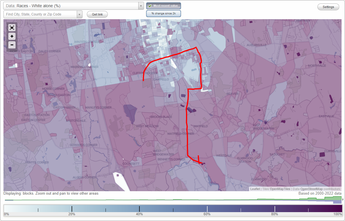
Campbello neighborhood in Brockton, Massachusetts (MA), 02379, 02301, 02302 detailed profile
Settings
X

Business Search - 14 Million verified businesses
Area: 2.704 square miles
Population: 10,589
Population density:
| Campbello: | 3,916 people per square mile |
| Brockton: | 4,883 people per square mile |

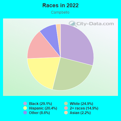
- 3,57529.1%Black
- 3,06324.9%White
- 2,50420.4%Hispanic or Latino
- 1,82614.9%Two or more races
- 1,0598.6%Some other race
- 2662.2%Asian
Median household income in 2022:
| Campbello: | $94,519 |
| Brockton: | $74,799 |
Distribution of median household income
![Distribution of median household income]()
- 321Less than $10,000
- 151$10,000 to $19,999
- 357$20,000 to $29,999
- 368$30,000 to $39,999
- 373$40,000 to $49,999
- 433$50,000 to $59,999
- 274$60,000 to $74,999
- 366$75,000 to $99,999
- 319$100,000 to $124,999
- 635$125,000 to $149,999
- 221$150,000 to $199,999
- 364$200,000 or more

Distribution of owner-occupied house/condo value
![Distribution of owner-occupied house/condo value]()
- 620Less than $50,000
- 235$50,000 to $99,999
- 46$100,000 to $149,999
- 82$150,000 to $199,999
- 624$200,000 to $249,999
- 329$250,000 to $299,999
- 697$300,000 to $399,999
- 378$400,000 to $499,999
- 352$500,000 to $749,999
- 142$750,000 to $999,999
- 62$1,000,000 or more

Distribution of rent paid by renters
![Distribution of rent paid by renters]()
- 17$100 to $199
- 179$200 to $299
- 64$300 to $399
- 167$400 to $499
- 570$500 to $599
- 45$600 to $699
- 375$700 to $799
- 8$800 to $899
- 1,065$900 to $999
- 500$1,000 to $1,249
- 425$1,250 to $1,499
- 462$1,500 to $1,999
- 107$2,000 or more

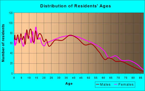
| Males: | 4,924 |
| Females: | 5,664 |
Males:
| This neighborhood: | 34.4 years |
| Whole city: | 38.6 years |
| This neighborhood: | 44.3 years |
| Whole city: | 40.5 years |
Average household size:
| Campbello: | 6.2 people |
| Brockton: | 2.7 people |
Percentage of family households:
| Campbello: | 44.0% |
| Brockton: | 53.0% |
| Here: | 37.3% |
| Brockton: | 40.8% |
Percentage of married-couple families with children (among all households):
| Campbello: | 11.2% |
| Brockton: | 21.6% |
Percentage of single-mother households (among all households):
| Campbello: | 22.4% |
| Brockton: | 11.6% |
Percentage of never married males 15 years old and over:
Percentage of never married females 15 years old and over:
| Campbello: | 20.5% |
| Brockton: | 19.2% |
Percentage of never married females 15 years old and over:
| Campbello: | 25.1% |
| city: | 22.2% |
Percentage of people that speak English not well or not at all:
| Campbello: | 7.5% |
| Brockton: | 10.4% |
Percentage of people born in this state:
Percentage of people born in another U.S. state:
Percentage of native residents but born outside the U.S.:
Percentage of foreign born residents:
| Here: | 60.6% |
| Brockton: | 54.1% |
Percentage of people born in another U.S. state:
| Campbello: | 6.2% |
| Brockton: | 9.1% |
Percentage of native residents but born outside the U.S.:
| Here: | 2.7% |
| city: | 4.1% |
Percentage of foreign born residents:
| Here: | 31.0% |
| Brockton: | 32.7% |

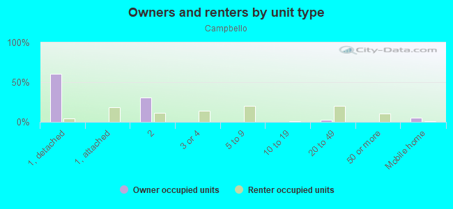
Owner-occupied
Renter-occupied

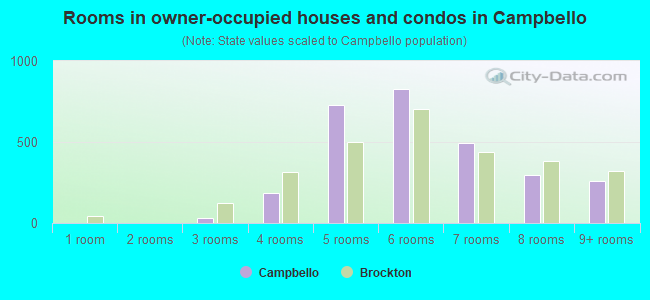
- Rooms in owner-occupied houses and condos in Campbello
- 01 room
- 02 rooms
- 313 rooms
- 1884 rooms
- 7275 rooms
- 8266 rooms
- 4957 rooms
- 2978 rooms
- 2589+ rooms
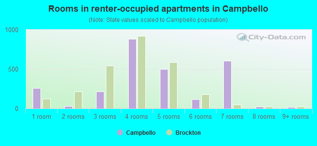
- Rooms in renter-occupied apartments in Campbello
- 2621 room
- 322 rooms
- 2133 rooms
- 8854 rooms
- 5005 rooms
- 1166 rooms
- 6037 rooms
- 238 rooms
- 199+ rooms
Owner-occupied
Renter-occupied
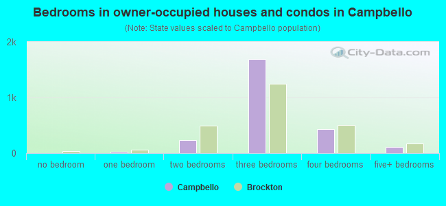
- Bedrooms in owner-occupied houses and condos in Campbello
- 0no bedroom
- 301 bedroom
- 2302 bedrooms
- 1,6903 bedrooms
- 4374 bedrooms
- 1175+ bedrooms
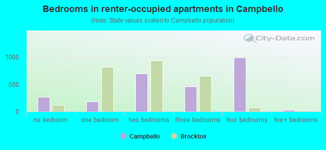
- Bedrooms in renter-occupied apartments in Campbello
- 262no bedroom
- 1851 bedroom
- 6942 bedrooms
- 4633 bedrooms
- 9914 bedrooms
- 235+ bedrooms
Average number of cars or other vehicles available in houses/condos:
Average number of cars or other vehicles available in apartments:
| This neighborhood: | 2.3 |
| Brockton: | 2.0 |
Average number of cars or other vehicles available in apartments:
| Here: | |
| city: |
Percentage of units with a mortgage:
| Campbello: | 73.1% |
| Brockton: | 77.5% |
Average estimated value of detached houses in 2022 (58.2% of all units):
| Campbello: | $380,827 |
| Massachusetts: | $651,570 |
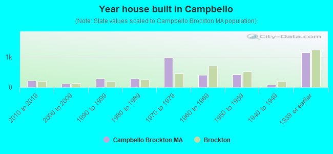
- Year house built in Campbello
- 02020 or later
- 2142010 to 2019
- 1262000 to 2009
- 2791990 to 1999
- 2831980 to 1989
- 9821970 to 1979
- 3971960 to 1969
- 4141950 to 1959
- 761940 to 1949
- 1,1401939 or earlier
City-data.com crime index for city in 2020 (higher means more crime):
| City: | 295.6 |
| U.S. average: | 219.5 |
Travel time to work (commute)
![Travel time to work (commute)]()
- 59Less than 5 minutes
- 3795 to 9 minutes
- 39810 to 14 minutes
- 22015 to 19 minutes
- 37720 to 24 minutes
- 24525 to 29 minutes
- 62030 to 34 minutes
- 4535 to 39 minutes
- 12040 to 44 minutes
- 34445 to 59 minutes
- 31260 to 89 minutes
- 17490 or more minutes

Means of transportation to work
![Means of transportation to work]()
- 70.1%3,412Drove a car alone
- 14.7%716Carpooled
- 17.3%844Bus
- 5.3%259Subway or elevated rail
- 2.1%104Long-distance train or commuter rail
- 0.4%18Taxi
- 8.3%406Bicycle
- 3.2%155Walked
- 1.7%82Other means
- 4.3%209Worked at home

Time leaving home to go to work
![Time leaving home to go to work]()
- 26612:00 a.m. to 4:59 a.m.
- 2105:00 a.m. to 5:29 a.m.
- 1005:30 a.m. to 5:59 a.m.
- 2496:00 a.m. to 6:29 a.m.
- 2956:30 a.m. to 6:59 a.m.
- 4557:00 a.m. to 7:29 a.m.
- 4637:30 a.m. to 7:59 a.m.
- 2378:00 a.m. to 8:29 a.m.
- 858:30 a.m. to 8:59 a.m.
- 1619:00 a.m. to 9:59 a.m.
- 12210:00 a.m. to 10:59 a.m.
- 7311:00 a.m. to 11:59 a.m.
- 33412:00 p.m. to 3:59 p.m.
- 2094:00 p.m. to 11:59 p.m.

Occupations of males:
- Percentage of males in management occupations (except farmers):
Here: 3.7% city: 7.1%
- Percentage of males in business and financial operations occupations:
Here: 1.3% city: 3.5%
- Percentage of males in computer and mathematical occupations:
Here: 8.6% city: 2.6%
- Percentage of males in architecture and engineering occupations:
Here: 1.4% city: 2.0%
- Percentage of males in community and social services occupations:
Here: 1.5% city: 2.1%
- Percentage of males in arts, design, entertainment, sports, and media occupations:
Here: 1.5% city: 1.1%
- Percentage of males in healthcare practitioners and technical occupations:
Here: 9.0% city: 2.8%
- Percentage of males in service occupations:
Here: 26.8% city: 20.9%
- Percentage of males in sales and office occupations:
Here: 11.3% city: 13.1%
- Percentage of males in construction, extraction, and maintenance occupations:
Here: 8.3% city: 11.5%
- Percentage of males in production occupations:
Here: 3.7% city: 6.4%
- Percentage of males in transportation occupations:
Here: 12.3% city: 12.8%
- Percentage of males in material moving occupations:
Here: 6.6% city: 6.8%
Occupations of females:
- Percentage of females in management occupations (except farmers):
Here: 1.0% city: 7.2%
- Percentage of females in business and financial operations occupations:
Here: 5.4% city: 3.5%
- Percentage of females in community and social services occupations:
Here: 7.5% city: 4.3%
- Percentage of females in education, training, and library occupations:
Here: 4.9% city: 7.4%
- Percentage of females in healthcare practitioners and technical occupations:
Here: 7.3% city: 9.4%
- Percentage of females in service occupations:
Here: 33.9% city: 31.4%
- Percentage of females in sales and office occupations:
Here: 31.2% city: 24.3%
- Percentage of females in farming, fishing, and forestry occupations:
Here: 3.0% city: 0.2%
- Percentage of females in transportation occupations:
Here: 1.2% city: 1.2%
- Percentage of females in material moving occupations:
Here: 2.3% city: 3.9%
Percentage of people 16-64 in Armed Forces:
| Campbello: | 0.0% |
| Brockton: | 0.1% |
Education in this neighborhood (subdivision or community):
- Percentage of people 3 years and older in K-12 schools:
Campbello: 24.3% Brockton: 15.6%
- Percentage of people 3 years and older in undergraduate colleges:
Campbello: 4.8% Brockton: 5.6%
- Percentage of people 3 years and older in grad. or professional schools:
Campbello: 0.8% Brockton: 2.3%
- Percentage of students K-12 enrolled in private schools:
Campbello: 29.8% Brockton: 6.9%
Percentage of population below poverty level:
| Campbello: | 13.8% |
| Brockton: | 15.3% |
Median year owner moved in (as recorded in 2022):
| Campbello: | 2001 |
| Brockton: | 2010 |
Percentage of married-couple families with both working:
| Campbello: | 106.9% |
| Brockton: | 82.8% |
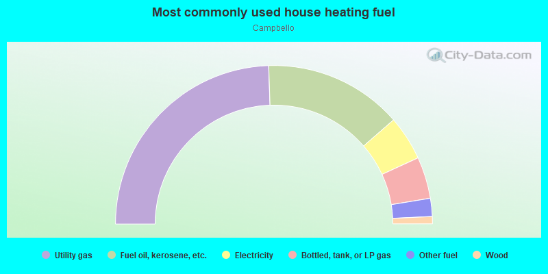
- 49.0%Utility gas
- 28.3%Fuel oil, kerosene, etc.
- 9.1%Electricity
- 8.5%Bottled, tank, or LP gas
- 3.7%Other fuel
- 1.5%Wood
Highways in this neighborhood:
State Hwy 28 (Main St)
Length: 1.49 miles
Directions: N-S, SE-NW
Address range: 1056 to 2099
Directions: N-S, SE-NW
Address range: 1056 to 2099
State Hwy 28 (Montello St)
Length: 0.29 miles
Directions: N-S, SW-NE
Address range: 1043 to 1247
Directions: N-S, SW-NE
Address range: 1043 to 1247
N Main St (State Hwy 28)
Length: 0.13 miles
Direction: N-S
Address range: 776 to 899
Direction: N-S
Address range: 776 to 899
Roads and streets:
Plain St
Length: 1.43 miles
Directions: E-W, SE-NW
Address range: 1 to 469
Directions: E-W, SE-NW
Address range: 1 to 469
Copeland St
Length: 1.43 miles
Directions: N-S, SE-NW
Address range: 1 to 564
Directions: N-S, SE-NW
Address range: 1 to 564
W Chestnut St
Length: 1.09 miles
Directions: E-W, SW-NE
Address range: 1 to 380
Directions: E-W, SW-NE
Address range: 1 to 380
Summer St
Length: 1.04 miles
Directions: E-W, N-S, SE-NW, SW-NE
Address range: 400 to 805
Directions: E-W, N-S, SE-NW, SW-NE
Address range: 400 to 805
Market St
Length: 0.90 miles
Directions: E-W, SW-NE
Address range: 1 to 298
Directions: E-W, SW-NE
Address range: 1 to 298
Carl Ave
Length: 0.85 miles
Directions: E-W, N-S, SE-NW
Address range: 1 to 321
Directions: E-W, N-S, SE-NW
Address range: 1 to 321
Perkins Ave
Length: 0.82 miles
Direction: E-W
Address range: 2 to 266
Direction: E-W
Address range: 2 to 266
Country Club Ln
Length: 0.69 miles
Directions: E-W, N-S, SE-NW, SW-NE
Address range: 1 to 254
Directions: E-W, N-S, SE-NW, SW-NE
Address range: 1 to 254
Riverview St
Length: 0.65 miles
Directions: E-W, N-S, SW-NE
Address range: 1 to 222
Directions: E-W, N-S, SW-NE
Address range: 1 to 222
Southworth St
Length: 0.65 miles
Directions: E-W, SE-NW
Address range: 1 to 208
Directions: E-W, SE-NW
Address range: 1 to 208
Samuel Ave
Length: 0.63 miles
Direction: E-W
Address range: 1 to 299
Direction: E-W
Address range: 1 to 299
Oak Hill Way
Length: 0.58 miles
Direction: SE-NW
Address range: 1 to 399
Direction: SE-NW
Address range: 1 to 399
Brookside Ave
Length: 0.55 miles
Direction: E-W
Address range: 1 to 170
Direction: E-W
Address range: 1 to 170
Clifton Ave
Length: 0.52 miles
Direction: E-W
Address range: 1 to 176
Direction: E-W
Address range: 1 to 176
Sargent's Way
Length: 0.49 miles
Directions: E-W, SW-NE
Directions: E-W, SW-NE
Forest St
Length: 0.49 miles
Directions: E-W, N-S, SE-NW
Address range: 1 to 199
Directions: E-W, N-S, SE-NW
Address range: 1 to 199
Hayward Ave
Length: 0.49 miles
Directions: E-W, SW-NE
Address range: 1 to 157
Directions: E-W, SW-NE
Address range: 1 to 157
Southfield Dr
Length: 0.47 miles
Directions: E-W, N-S, SE-NW, SW-NE
Address range: 1 to 32
Directions: E-W, N-S, SE-NW, SW-NE
Address range: 1 to 32
Leach Ave
Length: 0.44 miles
Directions: E-W, SW-NE
Address range: 1 to 203
Directions: E-W, SW-NE
Address range: 1 to 203
S Leyden St
Length: 0.42 miles
Direction: N-S
Address range: 1 to 183
Direction: N-S
Address range: 1 to 183
Southland Ter
Length: 0.42 miles
Directions: E-W, N-S, SE-NW, SW-NE
Address range: 2 to 160
Directions: E-W, N-S, SE-NW, SW-NE
Address range: 2 to 160
Keith Ave
Length: 0.41 miles
Directions: E-W, SE-NW
Address range: 1 to 152
Directions: E-W, SE-NW
Address range: 1 to 152
Langdon St
Length: 0.40 miles
Direction: E-W
Address range: 1 to 99
Direction: E-W
Address range: 1 to 99
Glen Ave
Length: 0.40 miles
Direction: E-W
Address range: 1 to 133
Direction: E-W
Address range: 1 to 133
Auburn St
Length: 0.40 miles
Direction: N-S
Address range: 1 to 170
Direction: N-S
Address range: 1 to 170
Keith Ave Exd
Length: 0.39 miles
Directions: E-W, SW-NE
Address range: 137 to 277
Directions: E-W, SW-NE
Address range: 137 to 277
Meadowbrook Rd
Length: 0.36 miles
Directions: N-S, SE-NW, SW-NE
Address range: 1 to 99
Directions: N-S, SE-NW, SW-NE
Address range: 1 to 99
Appleby St
Length: 0.34 miles
Directions: E-W, SE-NW, SW-NE
Address range: 1 to 135
Directions: E-W, SE-NW, SW-NE
Address range: 1 to 135
Hubbard Ave
Length: 0.34 miles
Direction: E-W
Address range: 1 to 199
Direction: E-W
Address range: 1 to 199
Brentwood Ave
Length: 0.33 miles
Direction: E-W
Address range: 1 to 199
Direction: E-W
Address range: 1 to 199
Hillside Ave
Length: 0.32 miles
Directions: E-W, SW-NE
Address range: 37 to 131
Directions: E-W, SW-NE
Address range: 37 to 131
Warren Ave
Length: 0.30 miles
Directions: N-S, SE-NW
Address range: 1089 to 1283
Directions: N-S, SE-NW
Address range: 1089 to 1283
Litchfield St
Length: 0.29 miles
Directions: E-W, SW-NE
Address range: 1 to 199
Directions: E-W, SW-NE
Address range: 1 to 199
Carleton Ave
Length: 0.28 miles
Direction: E-W
Address range: 1 to 99
Direction: E-W
Address range: 1 to 99
Concord St
Length: 0.27 miles
Directions: N-S, SE-NW
Address range: 111 to 299
Directions: N-S, SE-NW
Address range: 111 to 299
South St
Length: 0.26 miles
Direction: E-W
Address range: 1 to 86
Direction: E-W
Address range: 1 to 86
Woodside Ave
Length: 0.26 miles
Direction: E-W
Address range: 1 to 87
Direction: E-W
Address range: 1 to 87
Rutland Sq
Length: 0.26 miles
Directions: E-W, N-S, SE-NW
Address range: 1 to 74
Directions: E-W, N-S, SE-NW
Address range: 1 to 74
Coral St
Length: 0.25 miles
Direction: E-W
Address range: 1 to 82
Direction: E-W
Address range: 1 to 82
11th Ave
Length: 0.25 miles
Direction: N-S
Address range: 1 to 104
Direction: N-S
Address range: 1 to 104
Edson St
Length: 0.25 miles
Directions: E-W, SW-NE
Address range: 8 to 106
Directions: E-W, SW-NE
Address range: 8 to 106
Glendale Ave
Length: 0.25 miles
Directions: E-W, SW-NE
Address range: 1 to 99
Directions: E-W, SW-NE
Address range: 1 to 99
Churchill Ave
Length: 0.25 miles
Directions: N-S, SE-NW
Address range: 1 to 105
Directions: N-S, SE-NW
Address range: 1 to 105
Snell Ave
Length: 0.24 miles
Direction: N-S
Address range: 1 to 103
Direction: N-S
Address range: 1 to 103
Mercedes Rd
Length: 0.23 miles
Directions: N-S, SE-NW, SW-NE
Address range: 1 to 99
Directions: N-S, SE-NW, SW-NE
Address range: 1 to 99
Paulin Ave
Length: 0.23 miles
Directions: E-W, N-S, SE-NW
Address range: 1 to 83
Directions: E-W, N-S, SE-NW
Address range: 1 to 83
Baker St
Length: 0.23 miles
Directions: N-S, SE-NW
Address range: 1 to 99
Directions: N-S, SE-NW
Address range: 1 to 99
Lucy Ln
Length: 0.23 miles
Directions: E-W, N-S, SE-NW, SW-NE
Address range: 1 to 99
Directions: E-W, N-S, SE-NW, SW-NE
Address range: 1 to 99
12th Ave
Length: 0.23 miles
Directions: N-S, SW-NE
Address range: 1 to 102
Directions: N-S, SW-NE
Address range: 1 to 102
Geralynn Dr
Length: 0.22 miles
Directions: E-W, SE-NW
Address range: 1 to 100
Directions: E-W, SE-NW
Address range: 1 to 100
Cushing Ave
Length: 0.22 miles
Direction: E-W
Address range: 1 to 66
Direction: E-W
Address range: 1 to 66
Susan Rd
Length: 0.21 miles
Directions: E-W, N-S, SW-NE
Address range: 1 to 70
Directions: E-W, N-S, SW-NE
Address range: 1 to 70
Holmes St
Length: 0.21 miles
Direction: E-W
Address range: 1 to 69
Direction: E-W
Address range: 1 to 69
Oakside Ave
Length: 0.21 miles
Direction: E-W
Address range: 1 to 80
Direction: E-W
Address range: 1 to 80
Longworth Ave
Length: 0.21 miles
Directions: E-W, N-S, SE-NW
Address range: 1 to 39
Directions: E-W, N-S, SE-NW
Address range: 1 to 39
Country Club Dr
Length: 0.20 miles
Direction: E-W
Address range: 1 to 62
Direction: E-W
Address range: 1 to 62
Grant Ave
Length: 0.19 miles
Directions: N-S, SE-NW
Address range: 1 to 81
Directions: N-S, SE-NW
Address range: 1 to 81
Rapp Ave
Length: 0.19 miles
Directions: E-W, N-S
Directions: E-W, N-S
Noyes Ave
Length: 0.19 miles
Direction: N-S
Address range: 1 to 76
Direction: N-S
Address range: 1 to 76
Watson St
Length: 0.18 miles
Direction: E-W
Address range: 1 to 79
Direction: E-W
Address range: 1 to 79
Mobile Dr
Length: 0.18 miles
Directions: E-W, SW-NE
Address range: 1 to 7
Directions: E-W, SW-NE
Address range: 1 to 7
Dogwood Dr
Length: 0.18 miles
Directions: E-W, N-S, SE-NW, SW-NE
Address range: 22 to 42
Directions: E-W, N-S, SE-NW, SW-NE
Address range: 22 to 42
Palm Dr
Length: 0.18 miles
Directions: E-W, N-S, SE-NW, SW-NE
Address range: 45 to 71
Directions: E-W, N-S, SE-NW, SW-NE
Address range: 45 to 71
Stockholm Ave
Length: 0.18 miles
Direction: N-S
Address range: 1 to 199
Direction: N-S
Address range: 1 to 199
Churchill Ave Exd
Length: 0.17 miles
Directions: N-S, SE-NW
Address range: 1 to 99
Directions: N-S, SE-NW
Address range: 1 to 99
Meadow Ln
Length: 0.17 miles
Directions: E-W, SW-NE
Address range: 1 to 99
Directions: E-W, SW-NE
Address range: 1 to 99
Jane Ter
Length: 0.17 miles
Direction: N-S
Address range: 1 to 76
Direction: N-S
Address range: 1 to 76
Leyden Park Rd
Length: 0.17 miles
Directions: N-S, SE-NW
Address range: 15 to 100
Directions: N-S, SE-NW
Address range: 15 to 100
Lawson Ter
Length: 0.17 miles
Direction: E-W
Address range: 1 to 99
Direction: E-W
Address range: 1 to 99
Woodbine St
Length: 0.16 miles
Direction: N-S
Address range: 1 to 70
Direction: N-S
Address range: 1 to 70
Dunbar St
Length: 0.16 miles
Direction: SE-NW
Address range: 1 to 99
Direction: SE-NW
Address range: 1 to 99
Thayer Ave
Length: 0.16 miles
Directions: E-W, SW-NE
Address range: 1 to 60
Directions: E-W, SW-NE
Address range: 1 to 60
Litchfield Ter
Length: 0.16 miles
Directions: E-W, N-S, SE-NW
Address range: 1 to 76
Directions: E-W, N-S, SE-NW
Address range: 1 to 76
Atherton St
Length: 0.16 miles
Direction: E-W
Address range: 1 to 199
Direction: E-W
Address range: 1 to 199
Riverside Ave
Length: 0.15 miles
Directions: E-W, N-S, SE-NW
Address range: 1 to 60
Directions: E-W, N-S, SE-NW
Address range: 1 to 60
Hoover Ave
Length: 0.15 miles
Direction: N-S
Address range: 1 to 47
Direction: N-S
Address range: 1 to 47
Morrison Rd
Length: 0.15 miles
Direction: E-W
Address range: 1 to 52
Direction: E-W
Address range: 1 to 52
Poole Ave
Length: 0.15 miles
Direction: E-W
Address range: 1 to 55
Direction: E-W
Address range: 1 to 55
East Ave
Length: 0.15 miles
Directions: E-W, N-S, SW-NE
Address range: 1 to 48
Directions: E-W, N-S, SW-NE
Address range: 1 to 48
Jackson St
Length: 0.15 miles
Direction: N-S
Address range: 1 to 64
Direction: N-S
Address range: 1 to 64
Juneau Rd
Length: 0.14 miles
Direction: N-S
Address range: 1 to 63
Direction: N-S
Address range: 1 to 63
Irvington St
Length: 0.14 miles
Directions: N-S, SE-NW
Address range: 1 to 56
Directions: N-S, SE-NW
Address range: 1 to 56
Beach St
Length: 0.13 miles
Direction: N-S
Address range: 1 to 50
Direction: N-S
Address range: 1 to 50
Patricia Ln
Length: 0.13 miles
Directions: N-S, SE-NW
Address range: 1 to 55
Directions: N-S, SE-NW
Address range: 1 to 55
Burton Ave
Length: 0.12 miles
Directions: E-W, SW-NE
Address range: 1 to 48
Directions: E-W, SW-NE
Address range: 1 to 48
Vega Ave
Length: 0.12 miles
Direction: E-W
Address range: 1 to 44
Direction: E-W
Address range: 1 to 44
Greenwood Rd
Length: 0.12 miles
Direction: N-S
Address range: 1 to 99
Direction: N-S
Address range: 1 to 99
Green Pl
Length: 0.11 miles
Directions: N-S, SE-NW
Address range: 1 to 44
Directions: N-S, SE-NW
Address range: 1 to 44
Donald St
Length: 0.11 miles
Direction: SE-NW
Address range: 1 to 40
Direction: SE-NW
Address range: 1 to 40
E Chestnut St
Length: 0.11 miles
Direction: E-W
Address range: 1 to 42
Direction: E-W
Address range: 1 to 42
Station Ave
Length: 0.10 miles
Direction: SE-NW
Address range: 1 to 49
Direction: SE-NW
Address range: 1 to 49
Sylvia Ave
Length: 0.10 miles
Direction: E-W
Address range: 1 to 45
Direction: E-W
Address range: 1 to 45
Montello St Exd
Length: 0.10 miles
Direction: N-S
Address range: 1 to 58
Direction: N-S
Address range: 1 to 58
E Market St
Length: 0.10 miles
Direction: E-W
Address range: 1 to 40
Direction: E-W
Address range: 1 to 40
Sansom St
Length: 0.10 miles
Direction: E-W
Address range: 1 to 29
Direction: E-W
Address range: 1 to 29
Evans St
Length: 0.10 miles
Direction: E-W
Address range: 1 to 26
Direction: E-W
Address range: 1 to 26
Fisher Ave
Length: 0.09 miles
Direction: E-W
Address range: 1 to 35
Direction: E-W
Address range: 1 to 35
Simeon Ave
Length: 0.09 miles
Directions: N-S, SE-NW
Address range: 1 to 39
Directions: N-S, SE-NW
Address range: 1 to 39
Lilly Ave
Length: 0.09 miles
Direction: N-S
Address range: 1 to 37
Direction: N-S
Address range: 1 to 37
Garfield St
Length: 0.09 miles
Direction: E-W
Address range: 2 to 26
Direction: E-W
Address range: 2 to 26
Kenwood St
Length: 0.09 miles
Direction: E-W
Address range: 1 to 38
Direction: E-W
Address range: 1 to 38
Hardy Ave
Length: 0.09 miles
Direction: SE-NW
Address range: 1 to 39
Direction: SE-NW
Address range: 1 to 39
Otto St
Length: 0.09 miles
Direction: SW-NE
Address range: 1 to 28
Direction: SW-NE
Address range: 1 to 28
Wallace St
Length: 0.08 miles
Direction: N-S
Address range: 1 to 38
Direction: N-S
Address range: 1 to 38
Arlene St
Length: 0.08 miles
Direction: E-W
Address range: 1 to 28
Direction: E-W
Address range: 1 to 28
Berkley St
Length: 0.08 miles
Direction: SE-NW
Address range: 1 to 99
Direction: SE-NW
Address range: 1 to 99
Moore St
Length: 0.08 miles
Direction: N-S
Address range: 1 to 36
Direction: N-S
Address range: 1 to 36
Lyon Ave
Length: 0.08 miles
Direction: E-W
Address range: 1 to 39
Direction: E-W
Address range: 1 to 39
Millett St
Length: 0.07 miles
Direction: N-S
Address range: 1 to 37
Direction: N-S
Address range: 1 to 37
D St
Length: 0.07 miles
Direction: E-W
Address range: 1 to 28
Direction: E-W
Address range: 1 to 28
Pauline St
Length: 0.07 miles
Direction: E-W
Address range: 1 to 99
Direction: E-W
Address range: 1 to 99
Steven Way
Length: 0.06 miles
Direction: N-S
Direction: N-S
Pauls Way
Length: 0.06 miles
Directions: N-S, SW-NE
Address range: 1 to 99
Directions: N-S, SW-NE
Address range: 1 to 99
Bristol Ave
Length: 0.06 miles
Direction: SW-NE
Address range: 1 to 30
Direction: SW-NE
Address range: 1 to 30
Terminal Pl
Length: 0.06 miles
Direction: E-W
Address range: 1 to 30
Direction: E-W
Address range: 1 to 30
9th Ave
Length: 0.06 miles
Direction: N-S
Address range: 1 to 12
Direction: N-S
Address range: 1 to 12
Brook Dr
Length: 0.06 miles
Direction: SE-NW
Address range: 1 to 18
Direction: SE-NW
Address range: 1 to 18
Davis Ave
Length: 0.06 miles
Direction: SE-NW
Address range: 1 to 28
Direction: SE-NW
Address range: 1 to 28
Monarch St
Length: 0.06 miles
Direction: E-W
Address range: 1 to 25
Direction: E-W
Address range: 1 to 25
10th Ave
Length: 0.05 miles
Direction: N-S
Address range: 1 to 32
Direction: N-S
Address range: 1 to 32
N Leyden St
Length: 0.05 miles
Direction: N-S
Address range: 1 to 27
Direction: N-S
Address range: 1 to 27
Fieldstone Dr
Length: 0.05 miles
Direction: E-W
Address range: 1 to 99
Direction: E-W
Address range: 1 to 99
Greenwood Dr
Length: 0.05 miles
Direction: N-S
Address range: 39 to 72
Direction: N-S
Address range: 39 to 72
Alpine St
Length: 0.05 miles
Direction: E-W
Direction: E-W
Burton Pl
Length: 0.04 miles
Direction: SE-NW
Address range: 1 to 99
Direction: SE-NW
Address range: 1 to 99
N Elm St
Length: 0.04 miles
Direction: N-S
Address range: 673 to 699
Direction: N-S
Address range: 673 to 699
Vaughn Ct
Length: 0.04 miles
Direction: E-W
Address range: 1 to 26
Direction: E-W
Address range: 1 to 26
Judith Rd
Length: 0.04 miles
Direction: E-W
Address range: 1 to 26
Direction: E-W
Address range: 1 to 26
Hill Pl
Length: 0.04 miles
Direction: SE-NW
Address range: 1 to 99
Direction: SE-NW
Address range: 1 to 99
Wilkins Pl
Length: 0.03 miles
Direction: E-W
Address range: 1 to 20
Direction: E-W
Address range: 1 to 20
Francine Dr
Length: 0.03 miles
Direction: E-W
Address range: 35 to 58
Direction: E-W
Address range: 35 to 58
Railroad features:
Penn Central RR
Length: 1.73 miles
Direction: SE-NW
Direction: SE-NW
Other features:
Salisbury Plain Riv
Length: 2.03 miles
Directions: E-W, N-S, SE-NW, SW-NE
Directions: E-W, N-S, SE-NW, SW-NE
Edson Brk
Length: 1.17 miles
Directions: E-W, N-S, SE-NW, SW-NE
Directions: E-W, N-S, SE-NW, SW-NE
French Brk
Length: 0.71 miles
Directions: E-W, SE-NW, SW-NE
Directions: E-W, SE-NW, SW-NE