Charleston neighborhood in Staten Island, New York (NY), 10309 detailed profile
Settings
X


Business Search - 14 Million verified businesses
Area: 3.447 square miles
Population: 14,651
Population density:
| Charleston: | 4,250 people per square mile |
| Staten Island: | 7,588 people per square mile |

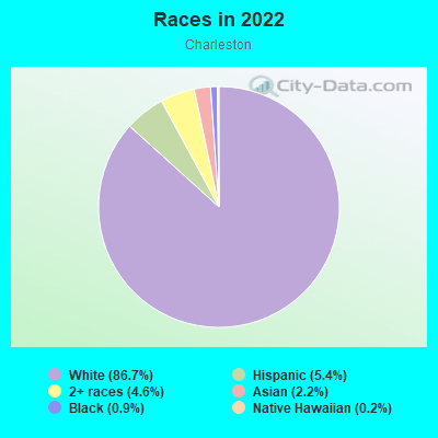
- 13,43386.7%White
- 8415.4%Hispanic or Latino
- 7184.6%Two or more races
- 3382.2%Asian
- 1420.9%Black
- 240.2%Native Hawaiian and Other
Pacific Islander
Distribution of median household income
![Distribution of median household income]()
- 49Less than $10,000
- 349$10,000 to $19,999
- 435$20,000 to $29,999
- 796$30,000 to $39,999
- 89$40,000 to $49,999
- 127$50,000 to $59,999
- 665$60,000 to $74,999
- 391$75,000 to $99,999
- 332$100,000 to $124,999
- 94$125,000 to $149,999
- 566$150,000 to $199,999
- 1,609$200,000 or more

Distribution of owner-occupied house/condo value
![Distribution of owner-occupied house/condo value]()
- 96Less than $50,000
- 161$50,000 to $99,999
- 31$250,000 to $299,999
- 68$300,000 to $399,999
- 399$400,000 to $499,999
- 1,431$500,000 to $749,999
- 1,615$750,000 to $999,999
- 940$1,000,000 or more

Distribution of rent paid by renters
![Distribution of rent paid by renters]()
- 193$400 to $499
- 203$1,000 to $1,249
- 122$1,250 to $1,499
- 490$1,500 to $1,999
- 1,695$2,000 or more

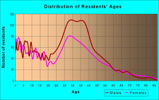
| Males: | 7,940 |
| Females: | 6,711 |
| Males: | 37.3 years |
| Females: | 43.3 years |
Average household size:
| Charleston: | 3.1 people |
| New York: | 2.5 people |
Percentage of family households:
| Charleston: | 53.3% |
| New York: | 41.3% |
| Here: | 69.3% |
| New York: | 42.3% |
Percentage of married-couple families with children (among all households):
| Charleston: | 29.5% |
| New York: | 57.0% |
Percentage of single-mother households (among all households):
| Charleston: | 2.7% |
| New York: | 9.3% |
Percentage of never married males 15 years old and over:
Percentage of never married females 15 years old and over:
| Charleston: | 12.3% |
| New York: | 19.8% |
Percentage of never married females 15 years old and over:
| Charleston: | 9.8% |
| New York: | 18.9% |
Percentage of people that speak English not well or not at all:
| Charleston: | 2.3% |
| New York: | 6.8% |
Percentage of people born in this state:
Percentage of people born in another U.S. state:
Percentage of native residents but born outside the U.S.:
Percentage of foreign born residents:
| Here: | 81.5% |
| New York: | 62.5% |
Percentage of people born in another U.S. state:
| Charleston: | 4.2% |
| New York: | 12.2% |
Percentage of native residents but born outside the U.S.:
| Here: | 1.2% |
| New York: | 2.6% |
Percentage of foreign born residents:
| Here: | 13.0% |
| New York: | 22.7% |
Owner-occupied
Renter-occupied

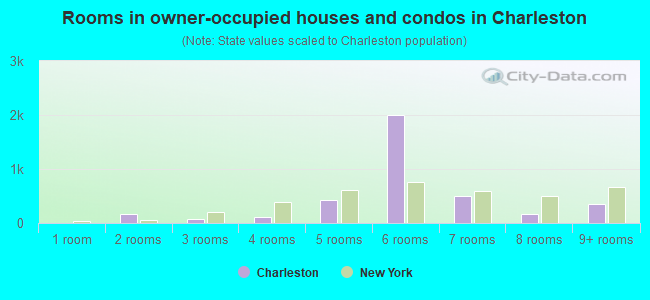
- Rooms in owner-occupied houses and condos in Charleston
- 01 room
- 1682 rooms
- 723 rooms
- 1204 rooms
- 4255 rooms
- 2,0056 rooms
- 5067 rooms
- 1598 rooms
- 3589+ rooms
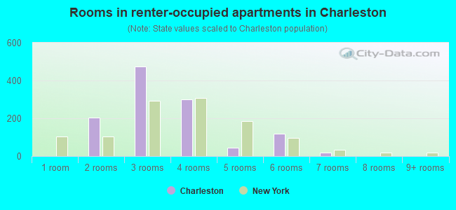
- Rooms in renter-occupied apartments in Charleston
- 01 room
- 2032 rooms
- 4753 rooms
- 3014 rooms
- 455 rooms
- 1206 rooms
- 197 rooms
- 08 rooms
- 09+ rooms
Owner-occupied
Renter-occupied
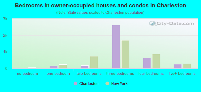
- Bedrooms in owner-occupied houses and condos in Charleston
- 0no bedroom
- 1671 bedroom
- 1842 bedrooms
- 2,6363 bedrooms
- 6464 bedrooms
- 2565+ bedrooms
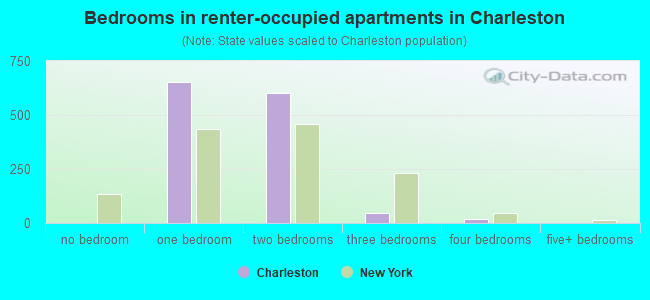
- Bedrooms in renter-occupied apartments in Charleston
- 0no bedroom
- 6521 bedroom
- 6032 bedrooms
- 453 bedrooms
- 194 bedrooms
- 05+ bedrooms
Average number of cars or other vehicles available in houses/condos:
Average number of cars or other vehicles available in apartments:
| This neighborhood: | 1.9 |
| New York: | 1.7 |
Average number of cars or other vehicles available in apartments:
| Here: | 1.2 |
| New York: | 0.7 |
Percentage of units with a mortgage:
| Charleston: | 64.7% |
| New York: | 58.3% |
Housing prices:
- Average estimated value of detached houses in 2022 (35.8% of all units):
Charleston: $815,968 New York: $476,719
- Average estimated value of townhouses or other attached units in 2022 (17.9% of all units):
This neighborhood: $731,288 New York: $699,270
- Average estimated value of housing units in 2-unit structures in 2022 (36.1% of all units):
This neighborhood: $820,347 New York: $713,077
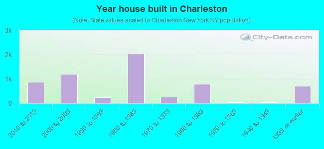
- Year house built in Charleston
- 02020 or later
- 8732010 to 2019
- 1,2012000 to 2009
- 2491990 to 1999
- 2,0621980 to 1989
- 2631970 to 1979
- 7891960 to 1969
- 421950 to 1959
- 321940 to 1949
- 7211939 or earlier

Travel time to work (commute)
![Travel time to work (commute)]()
- 31Less than 5 minutes
- 1615 to 9 minutes
- 52210 to 14 minutes
- 32815 to 19 minutes
- 39920 to 24 minutes
- 50125 to 29 minutes
- 67530 to 34 minutes
- 4035 to 39 minutes
- 20640 to 44 minutes
- 1,25845 to 59 minutes
- 1,01360 to 89 minutes
- 1,10090 or more minutes

Means of transportation to work
![Means of transportation to work]()
- 59.3%3,876Drove a car alone
- 8.6%564Carpooled
- 27.3%1,784Bus
- 1.7%109Subway or elevated rail
- 0.6%36Long-distance train or commuter rail
- 9.0%590Ferryboat
- 2.2%141Walked
- 3.2%210Worked at home

Time leaving home to go to work
![Time leaving home to go to work]()
- 23312:00 a.m. to 4:59 a.m.
- 3075:00 a.m. to 5:29 a.m.
- 5285:30 a.m. to 5:59 a.m.
- 6466:00 a.m. to 6:29 a.m.
- 5086:30 a.m. to 6:59 a.m.
- 1,5077:00 a.m. to 7:29 a.m.
- 6027:30 a.m. to 7:59 a.m.
- 2668:00 a.m. to 8:29 a.m.
- 2298:30 a.m. to 8:59 a.m.
- 3119:00 a.m. to 9:59 a.m.
- 20610:00 a.m. to 10:59 a.m.
- 11211:00 a.m. to 11:59 a.m.
- 23012:00 p.m. to 3:59 p.m.
- 1654:00 p.m. to 11:59 p.m.

Occupations of males:
- Percentage of males in management occupations (except farmers):
Here: 21.2% New York: 11.9%
- Percentage of males in business and financial operations occupations:
Here: 9.0% New York: 5.8%
- Percentage of males in computer and mathematical occupations:
Here: 9.2% New York: 4.6%
- Percentage of males in education, training, and library occupations:
Here: 6.1% New York: 4.2%
- Percentage of males in service occupations:
Here: 6.7% New York: 16.9%
- Percentage of males in sales and office occupations:
Here: 18.9% New York: 15.2%
- Percentage of males in construction, extraction, and maintenance occupations:
Here: 1.5% New York: 8.2%
- Percentage of males in production occupations:
Here: 10.6% New York: 4.6%
- Percentage of males in transportation occupations:
Here: 9.8% New York: 6.7%
Occupations of females:
- Percentage of females in management occupations (except farmers):
Here: 6.4% New York: 9.8%
- Percentage of females in business and financial operations occupations:
Here: 6.1% New York: 6.5%
- Percentage of females in computer and mathematical occupations:
Here: 3.8% New York: 1.6%
- Percentage of females in legal occupations:
Here: 2.1% New York: 1.9%
- Percentage of females in education, training, and library occupations:
Here: 18.8% New York: 11.3%
- Percentage of females in healthcare practitioners and technical occupations:
Here: 17.5% New York: 9.7%
- Percentage of females in service occupations:
Here: 8.1% New York: 21.4%
- Percentage of females in sales and office occupations:
Here: 36.3% New York: 24.9%
- Percentage of females in transportation occupations:
Here: 1.3% New York: 1.0%
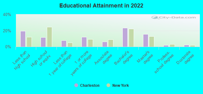
Education in this neighborhood (subdivision or community):
- Percentage of people 3 years and older in K-12 schools:
Charleston: 28.5% New York: 15.4%
- Percentage of people 3 years and older in undergraduate colleges:
Charleston: 3.1% New York: 5.3%
- Percentage of people 3 years and older in grad. or professional schools:
Charleston: 2.6% New York: 1.8%
- Percentage of students K-12 enrolled in private schools:
Charleston: 14.6% New York: 15.5%
Percentage of population below poverty level:
| Charleston: | 11.6% |
| New York: | 14.3% |
Median year owner moved in (as recorded in 2022):
Median year renter moved in (as recorded in 2022):
| Charleston: | 2019 |
| New York: | 2007 |
Median year renter moved in (as recorded in 2022):
| Charleston: | 2023 |
| New York: | 2018 |
Percentage of married-couple families with both working:
| Charleston: | 50.4% |
| New York: | 72.1% |
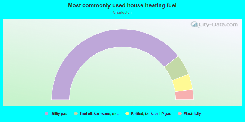
- 78.8%Utility gas
- 9.4%Fuel oil, kerosene, etc.
- 7.1%Bottled, tank, or LP gas
- 4.7%Electricity
Highways in this neighborhood:
Outerbridge Xing (Richmond Pkwy, State Hwy 440)
Length: 2.02 miles
Direction: E-W
Direction: E-W
Roads and streets:
Arthur Kill Rd
Length: 3.31 miles
Directions: E-W, N-S, SE-NW, SW-NE
Address range: 2300 to 4849
Directions: E-W, N-S, SE-NW, SW-NE
Address range: 2300 to 4849
Veterans Rd W
Length: 3.10 miles
Directions: E-W, N-S, SW-NE
Address range: 501 to 3199
Directions: E-W, N-S, SW-NE
Address range: 501 to 3199
W Shore Pkwy
Length: 2.42 miles
Directions: N-S, SW-NE
Directions: N-S, SW-NE
Bloomingdale Rd
Length: 2.40 miles
Directions: E-W, N-S, SE-NW, SW-NE
Address range: 147 to 1299
Directions: E-W, N-S, SE-NW, SW-NE
Address range: 147 to 1299
Veterans Rd E
Length: 2.32 miles
Directions: E-W, N-S, SE-NW, SW-NE
Address range: 60 to 99
Directions: E-W, N-S, SE-NW, SW-NE
Address range: 60 to 99
Sharrotts Rd
Length: 1.77 miles
Directions: E-W, N-S
Address range: 1 to 899
Directions: E-W, N-S
Address range: 1 to 899
Englewood Ave
Length: 1.31 miles
Direction: E-W
Address range: 1 to 514
Direction: E-W
Address range: 1 to 514
Clay Pit Rd
Length: 1.24 miles
Direction: E-W
Address range: 1 to 399
Direction: E-W
Address range: 1 to 399
Industrial Loop
Length: 0.90 miles
Directions: SE-NW, SW-NE
Address range: 81 to 486
Directions: SE-NW, SW-NE
Address range: 81 to 486
Woodrow Rd
Length: 0.69 miles
Direction: E-W
Address range: 1480 to 1698
Direction: E-W
Address range: 1480 to 1698
Winant Ave
Length: 0.67 miles
Directions: N-S, SE-NW
Address range: 115 to 585
Directions: N-S, SE-NW
Address range: 115 to 585
Ellis Rd
Length: 0.63 miles
Direction: E-W
Direction: E-W
Shore St (Coke St, Johnson St)
Length: 0.56 miles
Direction: SE-NW
Address range: 1 to 211
Direction: SE-NW
Address range: 1 to 211
Chemical Ln
Length: 0.53 miles
Direction: SE-NW
Address range: 1001 to 1999
Direction: SE-NW
Address range: 1001 to 1999
Androvette St
Length: 0.40 miles
Direction: E-W
Address range: 1 to 238
Direction: E-W
Address range: 1 to 238
Boscombe Ave
Length: 0.40 miles
Direction: E-W
Address range: 174 to 299
Direction: E-W
Address range: 174 to 299
Darnell Ln
Length: 0.36 miles
Directions: E-W, N-S
Address range: 29 to 198
Directions: E-W, N-S
Address range: 29 to 198
Churchill Ave
Length: 0.35 miles
Direction: E-W
Address range: 1 to 199
Direction: E-W
Address range: 1 to 199
Storer Ave
Length: 0.35 miles
Direction: E-W
Address range: 1 to 131
Direction: E-W
Address range: 1 to 131
S Bridge St
Length: 0.34 miles
Directions: E-W, SE-NW
Address range: 7 to 120
Directions: E-W, SE-NW
Address range: 7 to 120
Pembrook Loop
Length: 0.34 miles
Directions: E-W, N-S, SE-NW, SW-NE
Address range: 1 to 225
Directions: E-W, N-S, SE-NW, SW-NE
Address range: 1 to 225
Marisa Cir
Length: 0.34 miles
Directions: E-W, N-S
Address range: 2 to 198
Directions: E-W, N-S
Address range: 2 to 198
Kent St
Length: 0.33 miles
Directions: E-W, N-S
Directions: E-W, N-S
Harris Ln
Length: 0.32 miles
Directions: E-W, N-S
Address range: 1 to 450
Directions: E-W, N-S
Address range: 1 to 450
Herrick Ave
Length: 0.31 miles
Direction: E-W
Address range: 1 to 121
Direction: E-W
Address range: 1 to 121
Lorraine Loop
Length: 0.31 miles
Directions: E-W, N-S
Address range: 2 to 236
Directions: E-W, N-S
Address range: 2 to 236
Kreischer St
Length: 0.31 miles
Directions: E-W, N-S, SE-NW
Address range: 1 to 152
Directions: E-W, N-S, SE-NW
Address range: 1 to 152
N Bridge St
Length: 0.30 miles
Direction: E-W
Address range: 1 to 31
Direction: E-W
Address range: 1 to 31
Winant Pl
Length: 0.28 miles
Direction: E-W
Address range: 1 to 199
Direction: E-W
Address range: 1 to 199
Hargold Ave
Length: 0.28 miles
Direction: E-W
Address range: 474 to 500
Direction: E-W
Address range: 474 to 500
Lundsten Ave
Length: 0.27 miles
Direction: E-W
Address range: 1 to 74
Direction: E-W
Address range: 1 to 74
Ambassador Ln
Length: 0.27 miles
Directions: E-W, N-S
Address range: 2 to 74
Directions: E-W, N-S
Address range: 2 to 74
Wirt Ave
Length: 0.27 miles
Direction: E-W
Address range: 100 to 212
Direction: E-W
Address range: 100 to 212
Crab Tree Ave (Crabtree Ave)
Length: 0.26 miles
Direction: E-W
Address range: 1 to 199
Direction: E-W
Address range: 1 to 199
Dexter Ave
Length: 0.25 miles
Directions: E-W, N-S, SE-NW, SW-NE
Address range: 1 to 99
Directions: E-W, N-S, SE-NW, SW-NE
Address range: 1 to 99
Drumgoole Rd W
Length: 0.25 miles
Direction: E-W
Direction: E-W
Drumgoole Rd E
Length: 0.23 miles
Direction: E-W
Direction: E-W
Robin Ct
Length: 0.23 miles
Directions: E-W, N-S, SE-NW, SW-NE
Address range: 1 to 87
Directions: E-W, N-S, SE-NW, SW-NE
Address range: 1 to 87
S Svc Rd
Length: 0.22 miles
Directions: E-W, SW-NE
Address range: 1924 to 1930
Directions: E-W, SW-NE
Address range: 1924 to 1930
Sharrotts Ln
Length: 0.22 miles
Directions: E-W, N-S
Address range: 35 to 73
Directions: E-W, N-S
Address range: 35 to 73
Tyrellan Ave
Length: 0.21 miles
Direction: N-S
Direction: N-S
Lucille Ave
Length: 0.21 miles
Direction: E-W
Address range: 107 to 205
Direction: E-W
Address range: 107 to 205
Correll Ave
Length: 0.21 miles
Direction: E-W
Address range: 701 to 799
Direction: E-W
Address range: 701 to 799
Ramona Ave
Length: 0.21 miles
Direction: E-W
Address range: 929 to 979
Direction: E-W
Address range: 929 to 979
Shiel Ave
Length: 0.21 miles
Direction: E-W
Address range: 100 to 205
Direction: E-W
Address range: 100 to 205
Radigan Ave
Length: 0.21 miles
Direction: E-W
Address range: 80 to 169
Direction: E-W
Address range: 80 to 169
Kramer Ave
Length: 0.21 miles
Direction: E-W
Address range: 288 to 362
Direction: E-W
Address range: 288 to 362
Mason Blvd
Length: 0.20 miles
Direction: E-W
Address range: 260 to 356
Direction: E-W
Address range: 260 to 356
Mc Baine Ave
Length: 0.20 miles
Direction: E-W
Address range: 270 to 347
Direction: E-W
Address range: 270 to 347
Marvin Rd
Length: 0.20 miles
Directions: E-W, N-S, SW-NE
Address range: 1 to 99
Directions: E-W, N-S, SW-NE
Address range: 1 to 99
Salamander Ct
Length: 0.20 miles
Directions: E-W, N-S
Address range: 1 to 135
Directions: E-W, N-S
Address range: 1 to 135
Marjorie St
Length: 0.19 miles
Directions: E-W, N-S
Address range: 2 to 98
Directions: E-W, N-S
Address range: 2 to 98
Trioka Way
Length: 0.19 miles
Direction: SE-NW
Address range: 15 to 65
Direction: SE-NW
Address range: 15 to 65
Nielsen Ave
Length: 0.19 miles
Direction: E-W
Address range: 1 to 100
Direction: E-W
Address range: 1 to 100
Pitney Ave
Length: 0.19 miles
Direction: E-W
Address range: 1 to 120
Direction: E-W
Address range: 1 to 120
Ashley Ln
Length: 0.16 miles
Direction: N-S
Address range: 1 to 82
Direction: N-S
Address range: 1 to 82
Gaynor St
Length: 0.16 miles
Direction: N-S
Address range: 235 to 251
Direction: N-S
Address range: 235 to 251
Lynbrook Ave
Length: 0.16 miles
Direction: N-S
Address range: 1 to 99
Direction: N-S
Address range: 1 to 99
Sandywood Ln
Length: 0.15 miles
Directions: E-W, N-S
Address range: 1 to 99
Directions: E-W, N-S
Address range: 1 to 99
Carlin St
Length: 0.15 miles
Direction: N-S
Address range: 1 to 99
Direction: N-S
Address range: 1 to 99
Pheasant Ln
Length: 0.14 miles
Directions: E-W, N-S
Address range: 1 to 73
Directions: E-W, N-S
Address range: 1 to 73
Malvine Ave
Length: 0.13 miles
Direction: E-W
Address range: 88 to 312
Direction: E-W
Address range: 88 to 312
St Lukes Ave
Length: 0.13 miles
Directions: N-S, SE-NW
Address range: 1 to 50
Directions: N-S, SE-NW
Address range: 1 to 50
Red Cedar Ln
Length: 0.13 miles
Direction: N-S
Address range: 1 to 52
Direction: N-S
Address range: 1 to 52
Alysia Ct
Length: 0.13 miles
Direction: E-W
Address range: 1 to 100
Direction: E-W
Address range: 1 to 100
White Oak Ln
Length: 0.12 miles
Direction: N-S
Address range: 2 to 57
Direction: N-S
Address range: 2 to 57
Poplar Ave
Length: 0.12 miles
Direction: E-W
Direction: E-W
Quail Ln
Length: 0.12 miles
Directions: E-W, N-S
Address range: 2 to 65
Directions: E-W, N-S
Address range: 2 to 65
Anthony St
Length: 0.12 miles
Direction: E-W
Direction: E-W
Candon Ave
Length: 0.12 miles
Direction: E-W
Address range: 225 to 312
Direction: E-W
Address range: 225 to 312
Westfield Ave
Length: 0.11 miles
Direction: E-W
Direction: E-W
Hemlock Ln
Length: 0.11 miles
Direction: E-W
Address range: 14 to 42
Direction: E-W
Address range: 14 to 42
Spruce Ln
Length: 0.11 miles
Direction: E-W
Address range: 27 to 46
Direction: E-W
Address range: 27 to 46
Charleston Ave
Length: 0.11 miles
Direction: E-W
Address range: 122 to 175
Direction: E-W
Address range: 122 to 175
Turner St
Length: 0.11 miles
Directions: N-S, SE-NW
Address range: 50 to 645
Directions: N-S, SE-NW
Address range: 50 to 645
Helene Ct
Length: 0.11 miles
Directions: N-S, SE-NW
Address range: 1 to 82
Directions: N-S, SE-NW
Address range: 1 to 82
Peacock Loop
Length: 0.11 miles
Directions: E-W, N-S
Directions: E-W, N-S
Rossville Ave
Length: 0.11 miles
Directions: N-S, SE-NW
Address range: 1135 to 1171
Directions: N-S, SE-NW
Address range: 1135 to 1171
Jessica Ln
Length: 0.10 miles
Directions: E-W, N-S
Address range: 1 to 99
Directions: E-W, N-S
Address range: 1 to 99
Mallard Ln
Length: 0.10 miles
Direction: E-W
Address range: 1 to 99
Direction: E-W
Address range: 1 to 99
Hervey St
Length: 0.10 miles
Direction: E-W
Address range: 1 to 37
Direction: E-W
Address range: 1 to 37
Gladwin St
Length: 0.10 miles
Direction: N-S
Address range: 2 to 151
Direction: N-S
Address range: 2 to 151
Norman St
Length: 0.10 miles
Direction: N-S
Address range: 2 to 50
Direction: N-S
Address range: 2 to 50
Sharon Ln
Length: 0.09 miles
Direction: E-W
Address range: 1 to 50
Direction: E-W
Address range: 1 to 50
Manley St
Length: 0.08 miles
Direction: N-S
Address range: 1 to 42
Direction: N-S
Address range: 1 to 42
Mohr St
Length: 0.08 miles
Directions: N-S, SE-NW
Directions: N-S, SE-NW
Allentown Ln
Length: 0.08 miles
Direction: E-W
Address range: 2570 to 2599
Direction: E-W
Address range: 2570 to 2599
Sylvan Ln
Length: 0.08 miles
Direction: N-S
Address range: 1 to 16
Direction: N-S
Address range: 1 to 16
Sonia Ct
Length: 0.08 miles
Direction: E-W
Address range: 1 to 48
Direction: E-W
Address range: 1 to 48
Trina Ln
Length: 0.08 miles
Direction: SE-NW
Direction: SE-NW
Poplar Ln
Length: 0.08 miles
Direction: E-W
Address range: 2 to 27
Direction: E-W
Address range: 2 to 27
Gaton St
Length: 0.07 miles
Direction: N-S
Address range: 1 to 199
Direction: N-S
Address range: 1 to 199
Cosmen St
Length: 0.07 miles
Direction: N-S
Direction: N-S
Mandy Ct
Length: 0.07 miles
Direction: E-W
Address range: 1 to 99
Direction: E-W
Address range: 1 to 99
Goethals Ave
Length: 0.07 miles
Direction: N-S
Address range: 1 to 100
Direction: N-S
Address range: 1 to 100
Zebra Pl
Length: 0.06 miles
Direction: N-S
Address range: 1 to 398
Direction: N-S
Address range: 1 to 398
Gladwin Ave
Length: 0.06 miles
Direction: N-S
Address range: 1 to 31
Direction: N-S
Address range: 1 to 31
Brienna Ct
Length: 0.06 miles
Direction: N-S
Address range: 1 to 31
Direction: N-S
Address range: 1 to 31
W Shore Expy
Length: 0.06 miles
Direction: N-S
Direction: N-S
Wirt Ln
Length: 0.06 miles
Directions: E-W, N-S
Address range: 1 to 32
Directions: E-W, N-S
Address range: 1 to 32
Engert St
Length: 0.06 miles
Direction: SE-NW
Address range: 1 to 25
Direction: SE-NW
Address range: 1 to 25
Prince Ln
Length: 0.06 miles
Directions: E-W, N-S
Address range: 13 to 40
Directions: E-W, N-S
Address range: 13 to 40
Majestic Ave
Length: 0.06 miles
Direction: E-W
Direction: E-W
Winant Ln
Length: 0.05 miles
Direction: E-W
Address range: 1 to 12
Direction: E-W
Address range: 1 to 12
Crab Tree Ln (Crabtree Ln)
Length: 0.05 miles
Directions: E-W, N-S
Directions: E-W, N-S
Dunhill Ave
Length: 0.05 miles
Direction: E-W
Address range: 1 to 99
Direction: E-W
Address range: 1 to 99
Woodrose Ln
Length: 0.05 miles
Direction: N-S
Direction: N-S
Igros Ct
Length: 0.05 miles
Direction: SE-NW
Address range: 1 to 29
Direction: SE-NW
Address range: 1 to 29
Yeshiva Ln
Length: 0.04 miles
Direction: SE-NW
Address range: 1 to 33
Direction: SE-NW
Address range: 1 to 33
Muriel St
Length: 0.04 miles
Direction: N-S
Direction: N-S
Grille Ct
Length: 0.04 miles
Direction: SE-NW
Address range: 1 to 30
Direction: SE-NW
Address range: 1 to 30
Lynbrook Ct
Length: 0.03 miles
Direction: E-W
Address range: 1 to 99
Direction: E-W
Address range: 1 to 99
Candon Ct
Length: 0.03 miles
Direction: N-S
Address range: 2 to 30
Direction: N-S
Address range: 2 to 30
Phyllis Ct
Length: 0.03 miles
Direction: N-S
Address range: 1 to 27
Direction: N-S
Address range: 1 to 27
Vera Cruz Pl
Length: 0.03 miles
Direction: E-W
Direction: E-W
Other features:
Mill Crk
Length: 0.46 miles
Directions: E-W, N-S, SE-NW, SW-NE
Directions: E-W, N-S, SE-NW, SW-NE
Lemon Crk
Length: 0.10 miles
Directions: N-S, SW-NE
Directions: N-S, SW-NE