Choate neighborhood in Newark, Delaware (DE), 19711, 19713 detailed profile
Settings
X

Business Search - 14 Million verified businesses
Area: 2.199 square miles
Population: 9,590
Population density:
| Choate: | 4,360 people per square mile |
| Newark: | 3,435 people per square mile |

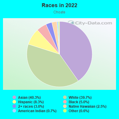
- 4,26840.3%Asian
- 4,20839.7%White
- 8758.3%Hispanic or Latino
- 5345.0%Black
- 3143.0%Two or more races
- 2602.5%Native Hawaiian and Other
Pacific Islander - 690.7%American Indian
- 680.6%Some other race
Median household income in 2022:
| Choate: | $77,150 |
| Newark: | $67,738 |
Distribution of median household income
![Distribution of median household income]()
- 159Less than $10,000
- 247$10,000 to $19,999
- 239$20,000 to $29,999
- 170$30,000 to $39,999
- 1,009$40,000 to $49,999
- 135$50,000 to $59,999
- 199$60,000 to $74,999
- 846$75,000 to $99,999
- 726$100,000 to $124,999
- 71$125,000 to $149,999
- 243$150,000 to $199,999
- 307$200,000 or more

Distribution of owner-occupied house/condo value
![Distribution of owner-occupied house/condo value]()
- 139Less than $50,000
- 40$50,000 to $99,999
- 700$100,000 to $149,999
- 219$150,000 to $199,999
- 230$200,000 to $249,999
- 534$250,000 to $299,999
- 413$300,000 to $399,999
- 78$400,000 to $499,999
- 19$500,000 to $749,999
- 88$750,000 to $999,999
- 92$1,000,000 or more

Distribution of rent paid by renters
![Distribution of rent paid by renters]()
- 197Less than $100
- 160$100 to $199
- 76$200 to $299
- 151$300 to $399
- 20$400 to $499
- 201$500 to $599
- 231$600 to $699
- 82$700 to $799
- 226$800 to $899
- 322$900 to $999
- 1,517$1,000 to $1,249
- 938$1,250 to $1,499
- 393$1,500 to $1,999
- 97$2,000 or more

| Males: | 5,010 |
| Females: | 4,580 |
Males:
| This neighborhood: | 37.7 years |
| Whole city: | 23.3 years |
| This neighborhood: | 36.8 years |
| Whole city: | 21.9 years |
Average household size:
| Choate: | 7.5 people |
| Newark: | 2.5 people |
Percentage of family households:
| Choate: | 53.8% |
| Newark: | 31.4% |
| Here: | 58.7% |
| Newark: | 38.8% |
Percentage of married-couple families with children (among all households):
| Choate: | 34.1% |
| Newark: | 23.9% |
Percentage of single-mother households (among all households):
| Choate: | 2.9% |
| Newark: | 4.6% |
Percentage of never married males 15 years old and over:
Percentage of never married females 15 years old and over:
| Choate: | 18.0% |
| Newark: | 31.6% |
Percentage of never married females 15 years old and over:
| Choate: | 18.1% |
| city: | 32.1% |
Percentage of people that speak English not well or not at all:
| Choate: | 3.4% |
| Newark: | 0.8% |
Percentage of people born in this state:
Percentage of people born in another U.S. state:
Percentage of native residents but born outside the U.S.:
Percentage of foreign born residents:
| Here: | 45.1% |
| Newark: | 30.8% |
Percentage of people born in another U.S. state:
| Choate: | 32.8% |
| Newark: | 54.2% |
Percentage of native residents but born outside the U.S.:
| Here: | 2.1% |
| city: | 2.0% |
Percentage of foreign born residents:
| Here: | 20.0% |
| Newark: | 12.9% |
Owner-occupied
Renter-occupied

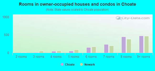
- Rooms in owner-occupied houses and condos in Choate
- 01 room
- 02 rooms
- 153 rooms
- 444 rooms
- 535 rooms
- 1536 rooms
- 2357 rooms
- 4518 rooms
- 4769+ rooms
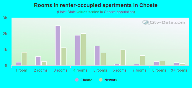
- Rooms in renter-occupied apartments in Choate
- 2001 room
- 5712 rooms
- 2,5233 rooms
- 1,9114 rooms
- 1,2365 rooms
- 1076 rooms
- 1157 rooms
- 2578 rooms
- 1829+ rooms
Owner-occupied
Renter-occupied
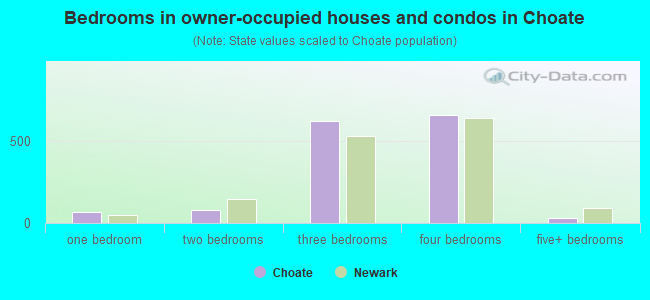
- Bedrooms in owner-occupied houses and condos in Choate
- 0no bedroom
- 651 bedroom
- 812 bedrooms
- 6183 bedrooms
- 6574 bedrooms
- 335+ bedrooms
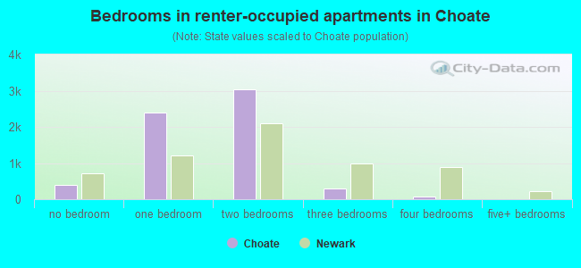
- Bedrooms in renter-occupied apartments in Choate
- 387no bedroom
- 2,3851 bedroom
- 3,0282 bedrooms
- 2873 bedrooms
- 654 bedrooms
- 05+ bedrooms
Average number of cars or other vehicles available in houses/condos:
Average number of cars or other vehicles available in apartments:
| This neighborhood: | 1.8 |
| Newark: | 1.9 |
Average number of cars or other vehicles available in apartments:
| Here: | 1.3 |
| city: | 1.6 |
Percentage of units with a mortgage:
| Choate: | 70.6% |
| Newark: | 63.1% |
Average estimated value of detached houses in 2022 (40.5% of all units):
| Choate: | $506,895 |
| Delaware: | $419,599 |
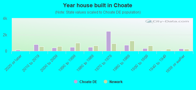
- Year house built in Choate
- 1302020 or later
- 7962010 to 2019
- 3952000 to 2009
- 4931990 to 1999
- 4731980 to 1989
- 2,4331970 to 1979
- 7281960 to 1969
- 3331950 to 1959
- 461940 to 1949
- 2891939 or earlier
Travel time to work (commute)
![Travel time to work (commute)]()
- 58Less than 5 minutes
- 3845 to 9 minutes
- 64310 to 14 minutes
- 85315 to 19 minutes
- 62120 to 24 minutes
- 23425 to 29 minutes
- 46730 to 34 minutes
- 5235 to 39 minutes
- 3840 to 44 minutes
- 29345 to 59 minutes
- 13260 to 89 minutes
- 5690 or more minutes

Means of transportation to work
![Means of transportation to work]()
- 63.0%3,105Drove a car alone
- 6.3%309Carpooled
- 1.1%53Bus
- 0.6%30Long-distance train or commuter rail
- 1.3%63Light rail, streetcar or trolley
- 6.2%306Taxi
- 0.4%18Motorcycle
- 2.2%109Bicycle
- 1.7%82Walked
- 11.4%564Other means
- 24.4%1,201Worked at home

Time leaving home to go to work
![Time leaving home to go to work]()
- 14512:00 a.m. to 4:59 a.m.
- 1125:00 a.m. to 5:29 a.m.
- 3025:30 a.m. to 5:59 a.m.
- 4656:00 a.m. to 6:29 a.m.
- 2366:30 a.m. to 6:59 a.m.
- 4857:00 a.m. to 7:29 a.m.
- 5677:30 a.m. to 7:59 a.m.
- 4748:00 a.m. to 8:29 a.m.
- 1328:30 a.m. to 8:59 a.m.
- 1959:00 a.m. to 9:59 a.m.
- 14310:00 a.m. to 10:59 a.m.
- 4711:00 a.m. to 11:59 a.m.
- 42812:00 p.m. to 3:59 p.m.
- 1204:00 p.m. to 11:59 p.m.

Occupations of males:
- Percentage of males in management occupations (except farmers):
Here: 6.5% city: 7.4%
- Percentage of males in business and financial operations occupations:
Here: 15.8% city: 4.2%
- Percentage of males in computer and mathematical occupations:
Here: 30.7% city: 5.2%
- Percentage of males in architecture and engineering occupations:
Here: 5.9% city: 3.8%
- Percentage of males in arts, design, entertainment, sports, and media occupations:
Here: 2.0% city: 4.7%
- Percentage of males in service occupations:
Here: 13.3% city: 11.5%
- Percentage of males in sales and office occupations:
Here: 12.4% city: 17.1%
- Percentage of males in construction, extraction, and maintenance occupations:
Here: 1.2% city: 5.6%
- Percentage of males in production occupations:
Here: 1.9% city: 3.2%
- Percentage of males in transportation occupations:
Here: 4.6% city: 3.1%
- Percentage of males in material moving occupations:
Here: 3.1% city: 5.7%
Occupations of females:
- Percentage of females in management occupations (except farmers):
Here: 11.3% city: 6.6%
- Percentage of females in business and financial operations occupations:
Here: 12.6% city: 9.9%
- Percentage of females in computer and mathematical occupations:
Here: 5.6% city: 2.5%
- Percentage of females in legal occupations:
Here: 10.4% city: 1.9%
- Percentage of females in education, training, and library occupations:
Here: 2.3% city: 13.0%
- Percentage of females in healthcare practitioners and technical occupations:
Here: 5.9% city: 4.7%
- Percentage of females in service occupations:
Here: 17.8% city: 26.7%
- Percentage of females in sales and office occupations:
Here: 28.1% city: 22.5%
- Percentage of females in material moving occupations:
Here: 2.8% city: 0.9%
Percentage of people 16-64 in Armed Forces:
| Choate: | 0.2% |
| Newark: | 0.4% |
Education in this neighborhood (subdivision or community):
- Percentage of people 3 years and older in K-12 schools:
Choate: 30.9% Newark: 9.3%
- Percentage of people 3 years and older in undergraduate colleges:
Choate: 7.4% Newark: 40.4%
- Percentage of people 3 years and older in grad. or professional schools:
Choate: 5.5% Newark: 3.9%
- Percentage of students K-12 enrolled in private schools:
Choate: 52.0% Newark: 12.3%
Percentage of population below poverty level:
| Choate: | 17.0% |
| Newark: | 24.4% |
Median year owner moved in (as recorded in 2022):
| Choate: | 2001 |
| Newark: | 2005 |
Percentage of married-couple families with both working:
| Choate: | 44.4% |
| Newark: | 79.7% |
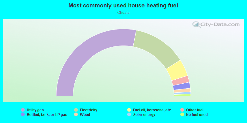
- 56.1%Utility gas
- 25.9%Electricity
- 8.2%Fuel oil, kerosene, etc.
- 3.2%Other fuel
- 2.9%Bottled, tank, or LP gas
- 1.7%Wood
- 1.1%Solar energy
- 0.9%No fuel used
Highways in this neighborhood:
State Rd 4
Length: 3.07 miles
Directions: E-W, SW-NE
Address range: 967 to 4435
Directions: E-W, SW-NE
Address range: 967 to 4435
Capitol Trl (State Rd 2)
Length: 1.99 miles
Directions: E-W, N-S, SE-NW, SW-NE
Address range: 1401 to 1999
Directions: E-W, N-S, SE-NW, SW-NE
Address range: 1401 to 1999
Kirkwood Hwy (Rte 2, State Rd 2)
Length: 0.36 miles
Direction: E-W
Address range: 2001 to 2049
Direction: E-W
Address range: 2001 to 2049
Ogletown Rd (State Rd 4, E Chestnut Hill Rd, State Rd 273)
Length: 0.20 miles
Direction: SW-NE
Direction: SW-NE
Christiana Pkwy (E Chestnut Hill Rd)
Length: 0.05 miles
Directions: E-W, SW-NE
Directions: E-W, SW-NE
State Rd 273
Length: 0.04 miles
Direction: E-W
Direction: E-W
Roads and streets:
Red Mill Rd
Length: 1.70 miles
Directions: E-W, N-S, SE-NW
Address range: 1 to 399
Directions: E-W, N-S, SE-NW
Address range: 1 to 399
N Harmony Rd
Length: 1.47 miles
Directions: N-S, SE-NW
Address range: 1 to 1906
Directions: N-S, SE-NW
Address range: 1 to 1906
Tamara Cir
Length: 1.47 miles
Directions: E-W, N-S, SE-NW, SW-NE
Address range: 1 to 699
Directions: E-W, N-S, SE-NW, SW-NE
Address range: 1 to 699
Old Harmony Rd
Length: 1.38 miles
Directions: E-W, N-S, SE-NW, SW-NE
Address range: 100 to 966
Directions: E-W, N-S, SE-NW, SW-NE
Address range: 100 to 966
Connector 273
Length: 1.38 miles
Directions: E-W, N-S, SE-NW
Directions: E-W, N-S, SE-NW
Ruthar Dr
Length: 1.14 miles
Directions: E-W, SW-NE
Address range: 100 to 398
Directions: E-W, SW-NE
Address range: 100 to 398
Melodic Dr
Length: 1.13 miles
Directions: E-W, N-S, SE-NW, SW-NE
Address range: 1 to 199
Directions: E-W, N-S, SE-NW, SW-NE
Address range: 1 to 199
Darwin Dr
Length: 0.96 miles
Directions: E-W, N-S, SE-NW, SW-NE
Address range: 1 to 599
Directions: E-W, N-S, SE-NW, SW-NE
Address range: 1 to 599
Harmony Rd
Length: 0.87 miles
Directions: E-W, N-S, SE-NW
Directions: E-W, N-S, SE-NW
Cheswold Blvd
Length: 0.77 miles
Directions: E-W, N-S, SE-NW, SW-NE
Address range: 1 to 99
Directions: E-W, N-S, SE-NW, SW-NE
Address range: 1 to 99
Durso Dr
Length: 0.73 miles
Directions: E-W, N-S, SE-NW, SW-NE
Address range: 100 to 699
Directions: E-W, N-S, SE-NW, SW-NE
Address range: 100 to 699
Piano Dr
Length: 0.66 miles
Directions: E-W, N-S, SE-NW, SW-NE
Address range: 100 to 198
Directions: E-W, N-S, SE-NW, SW-NE
Address range: 100 to 198
Greenridge Rd
Length: 0.65 miles
Directions: E-W, N-S, SW-NE
Address range: 1 to 99
Directions: E-W, N-S, SW-NE
Address range: 1 to 99
Brewster Dr
Length: 0.65 miles
Directions: E-W, N-S, SE-NW, SW-NE
Address range: 1 to 499
Directions: E-W, N-S, SE-NW, SW-NE
Address range: 1 to 499
Spring Lake Dr
Length: 0.61 miles
Directions: E-W, SE-NW, SW-NE
Address range: 1 to 99
Directions: E-W, SE-NW, SW-NE
Address range: 1 to 99
W Rutherford Dr
Length: 0.58 miles
Directions: E-W, N-S, SE-NW, SW-NE
Address range: 1 to 199
Directions: E-W, N-S, SE-NW, SW-NE
Address range: 1 to 199
Harmony Crest Dr
Length: 0.57 miles
Directions: E-W, SE-NW, SW-NE
Address range: 101 to 176
Directions: E-W, SE-NW, SW-NE
Address range: 101 to 176
Longview Dr
Length: 0.54 miles
Directions: E-W, N-S, SE-NW, SW-NE
Address range: 1 to 199
Directions: E-W, N-S, SE-NW, SW-NE
Address range: 1 to 199
Millwright Dr
Length: 0.53 miles
Directions: E-W, N-S, SW-NE
Address range: 1 to 99
Directions: E-W, N-S, SW-NE
Address range: 1 to 99
Phyllis Dr
Length: 0.53 miles
Directions: E-W, N-S, SE-NW, SW-NE
Address range: 1 to 199
Directions: E-W, N-S, SE-NW, SW-NE
Address range: 1 to 199
Diminish Dr
Length: 0.52 miles
Directions: E-W, SW-NE
Address range: 100 to 199
Directions: E-W, SW-NE
Address range: 100 to 199
E Rutherford Dr
Length: 0.51 miles
Directions: E-W, N-S, SE-NW, SW-NE
Address range: 1 to 141
Directions: E-W, N-S, SE-NW, SW-NE
Address range: 1 to 141
Old Manor Rd
Length: 0.50 miles
Directions: E-W, N-S, SW-NE
Address range: 1 to 99
Directions: E-W, N-S, SW-NE
Address range: 1 to 99
Prides Xing
Length: 0.44 miles
Directions: E-W, SE-NW, SW-NE
Directions: E-W, SE-NW, SW-NE
Creekside Dr
Length: 0.38 miles
Directions: E-W, N-S, SE-NW, SW-NE
Address range: 200 to 2999
Directions: E-W, N-S, SE-NW, SW-NE
Address range: 200 to 2999
Hudson Dr
Length: 0.35 miles
Directions: E-W, SW-NE
Address range: 300 to 499
Directions: E-W, SW-NE
Address range: 300 to 499
Sentry Ln
Length: 0.34 miles
Directions: E-W, SE-NW, SW-NE
Address range: 1 to 99
Directions: E-W, SE-NW, SW-NE
Address range: 1 to 99
Rolling Dr
Length: 0.33 miles
Direction: SE-NW
Address range: 1 to 199
Direction: SE-NW
Address range: 1 to 199
Catalina Dr
Length: 0.33 miles
Direction: SE-NW
Address range: 200 to 399
Direction: SE-NW
Address range: 200 to 399
Mc Cann Rd
Length: 0.30 miles
Directions: E-W, N-S, SE-NW, SW-NE
Address range: 1 to 199
Directions: E-W, N-S, SE-NW, SW-NE
Address range: 1 to 199
Pheasant Ln
Length: 0.29 miles
Directions: E-W, SE-NW
Address range: 2 to 199
Directions: E-W, SE-NW
Address range: 2 to 199
Fantasia Dr
Length: 0.29 miles
Directions: N-S, SE-NW, SW-NE
Address range: 100 to 199
Directions: N-S, SE-NW, SW-NE
Address range: 100 to 199
Ellsworth Dr
Length: 0.29 miles
Direction: SE-NW
Address range: 200 to 299
Direction: SE-NW
Address range: 200 to 299
Kingsley Dr
Length: 0.28 miles
Direction: SE-NW
Address range: 100 to 299
Direction: SE-NW
Address range: 100 to 299
Hull Ave
Length: 0.28 miles
Directions: N-S, SE-NW, SW-NE
Address range: 200 to 299
Directions: N-S, SE-NW, SW-NE
Address range: 200 to 299
Cheswold Bl
Length: 0.28 miles
Directions: SE-NW, SW-NE
Directions: SE-NW, SW-NE
Medley Dr
Length: 0.28 miles
Directions: E-W, SW-NE
Address range: 100 to 199
Directions: E-W, SW-NE
Address range: 100 to 199
Sussex Rd
Length: 0.27 miles
Directions: E-W, N-S, SE-NW, SW-NE
Address range: 1 to 98
Directions: E-W, N-S, SE-NW, SW-NE
Address range: 1 to 98
Ward Ln
Length: 0.26 miles
Directions: E-W, SE-NW
Directions: E-W, SE-NW
Happy Ln
Length: 0.25 miles
Directions: N-S, SE-NW
Address range: 1 to 199
Directions: N-S, SE-NW
Address range: 1 to 199
Gristmill Ln
Length: 0.24 miles
Directions: E-W, SE-NW
Address range: 1 to 99
Directions: E-W, SE-NW
Address range: 1 to 99
Sheffield Manor Dr
Length: 0.23 miles
Directions: N-S, SW-NE
Address range: 1 to 99
Directions: N-S, SW-NE
Address range: 1 to 99
Colfax Rd
Length: 0.22 miles
Direction: SE-NW
Address range: 100 to 199
Direction: SE-NW
Address range: 100 to 199
Patricia Ln
Length: 0.21 miles
Direction: SE-NW
Address range: 100 to 199
Direction: SE-NW
Address range: 100 to 199
Brookmead Rd
Length: 0.21 miles
Directions: N-S, SW-NE
Address range: 1 to 99
Directions: N-S, SW-NE
Address range: 1 to 99
Greenfield Rd
Length: 0.21 miles
Direction: SE-NW
Address range: 100 to 199
Direction: SE-NW
Address range: 100 to 199
Polly Drummond Hil Rd N (328)
Length: 0.21 miles
Direction: N-S
Direction: N-S
Polly Drummond Hill Rd
Length: 0.20 miles
Direction: N-S
Address range: 1 to 25
Direction: N-S
Address range: 1 to 25
Bass Ct
Length: 0.18 miles
Directions: E-W, N-S, SE-NW, SW-NE
Address range: 1 to 99
Directions: E-W, N-S, SE-NW, SW-NE
Address range: 1 to 99
Gabor Dr
Length: 0.18 miles
Directions: E-W, N-S, SE-NW, SW-NE
Directions: E-W, N-S, SE-NW, SW-NE
Chatham Ln
Length: 0.17 miles
Direction: E-W
Address range: 1 to 99
Direction: E-W
Address range: 1 to 99
Winchester Rd
Length: 0.17 miles
Direction: E-W
Address range: 2 to 99
Direction: E-W
Address range: 2 to 99
Mill Park Ct
Length: 0.16 miles
Directions: E-W, SW-NE
Address range: 1 to 99
Directions: E-W, SW-NE
Address range: 1 to 99
Duet Dr
Length: 0.15 miles
Directions: N-S, SE-NW
Address range: 100 to 199
Directions: N-S, SE-NW
Address range: 100 to 199
Octave Ct
Length: 0.15 miles
Directions: E-W, N-S, SE-NW, SW-NE
Address range: 1 to 99
Directions: E-W, N-S, SE-NW, SW-NE
Address range: 1 to 99
Alan Dr
Length: 0.15 miles
Direction: SE-NW
Address range: 100 to 199
Direction: SE-NW
Address range: 100 to 199
Elizabeth Ct
Length: 0.14 miles
Directions: N-S, SE-NW
Address range: 1 to 99
Directions: N-S, SE-NW
Address range: 1 to 99
Green Valley Dr W
Length: 0.14 miles
Directions: E-W, SE-NW, SW-NE
Directions: E-W, SE-NW, SW-NE
Flute Dr
Length: 0.14 miles
Directions: E-W, SW-NE
Address range: 1 to 99
Directions: E-W, SW-NE
Address range: 1 to 99
Old Red Mill Rd
Length: 0.14 miles
Directions: E-W, N-S, SE-NW, SW-NE
Address range: 1 to 199
Directions: E-W, N-S, SE-NW, SW-NE
Address range: 1 to 199
Hardin Ln
Length: 0.14 miles
Directions: E-W, N-S, SW-NE
Address range: 1 to 99
Directions: E-W, N-S, SW-NE
Address range: 1 to 99
Michelle Ct
Length: 0.13 miles
Directions: E-W, SW-NE
Address range: 100 to 599
Directions: E-W, SW-NE
Address range: 100 to 599
Old Capitol Trl
Length: 0.13 miles
Direction: E-W
Address range: 1900 to 1999
Direction: E-W
Address range: 1900 to 1999
Allandale Dr
Length: 0.13 miles
Directions: E-W, SW-NE
Directions: E-W, SW-NE
Richards Ln
Length: 0.13 miles
Directions: N-S, SE-NW
Address range: 100 to 199
Directions: N-S, SE-NW
Address range: 100 to 199
Lute Ct
Length: 0.12 miles
Directions: E-W, SE-NW
Address range: 1 to 99
Directions: E-W, SE-NW
Address range: 1 to 99
Harmony Ct
Length: 0.11 miles
Directions: SE-NW, SW-NE
Address range: 1 to 99
Directions: SE-NW, SW-NE
Address range: 1 to 99
Trombone Rd
Length: 0.11 miles
Directions: N-S, SE-NW
Address range: 1 to 23
Directions: N-S, SE-NW
Address range: 1 to 23
Barrett Ln
Length: 0.11 miles
Direction: E-W
Direction: E-W
Medill Ln
Length: 0.11 miles
Direction: SE-NW
Address range: 1 to 99
Direction: SE-NW
Address range: 1 to 99
352 (Red Mill Rd N)
Length: 0.11 miles
Direction: N-S
Direction: N-S
Madeline Ct
Length: 0.10 miles
Directions: E-W, N-S, SE-NW
Address range: 100 to 699
Directions: E-W, N-S, SE-NW
Address range: 100 to 699
Darby Rd
Length: 0.10 miles
Direction: SE-NW
Address range: 1 to 99
Direction: SE-NW
Address range: 1 to 99
E Ruthar Dr
Length: 0.10 miles
Direction: SW-NE
Address range: 3 to 13
Direction: SW-NE
Address range: 3 to 13
Flora Cir
Length: 0.09 miles
Directions: N-S, SE-NW, SW-NE
Address range: 1 to 99
Directions: N-S, SE-NW, SW-NE
Address range: 1 to 99
Unison Ct N
Length: 0.09 miles
Directions: N-S, SE-NW
Address range: 1 to 99
Directions: N-S, SE-NW
Address range: 1 to 99
Drummond Plz
Length: 0.08 miles
Direction: N-S
Address range: 1000 to 3399
Direction: N-S
Address range: 1000 to 3399
Tone Ct
Length: 0.07 miles
Directions: N-S, SE-NW, SW-NE
Address range: 1 to 99
Directions: N-S, SE-NW, SW-NE
Address range: 1 to 99
Harmony Rd N (355)
Length: 0.07 miles
Directions: E-W, N-S, SE-NW
Directions: E-W, N-S, SE-NW
Mary Ann Ct
Length: 0.07 miles
Directions: N-S, SE-NW, SW-NE
Address range: 100 to 399
Directions: N-S, SE-NW, SW-NE
Address range: 100 to 399
Brookbend Dr
Length: 0.07 miles
Directions: E-W, N-S, SW-NE
Directions: E-W, N-S, SW-NE
Clearview Ct
Length: 0.07 miles
Directions: E-W, SW-NE
Address range: 1 to 99
Directions: E-W, SW-NE
Address range: 1 to 99
Acapella Ct
Length: 0.07 miles
Directions: N-S, SW-NE
Address range: 1 to 99
Directions: N-S, SW-NE
Address range: 1 to 99
Renee Ct
Length: 0.07 miles
Direction: SE-NW
Address range: 1 to 14
Direction: SE-NW
Address range: 1 to 14
Engel Pl
Length: 0.07 miles
Direction: SW-NE
Address range: 100 to 199
Direction: SW-NE
Address range: 100 to 199
Earlington Ln
Length: 0.07 miles
Direction: SE-NW
Address range: 1 to 99
Direction: SE-NW
Address range: 1 to 99
Latham Ln
Length: 0.06 miles
Direction: N-S
Direction: N-S
Greenfield Ct
Length: 0.06 miles
Direction: SE-NW
Address range: 1 to 99
Direction: SE-NW
Address range: 1 to 99
Unision Ct
Length: 0.06 miles
Directions: E-W, N-S, SW-NE
Address range: 1 to 14
Directions: E-W, N-S, SW-NE
Address range: 1 to 14
Coronet Ct
Length: 0.06 miles
Direction: SE-NW
Address range: 1 to 99
Direction: SE-NW
Address range: 1 to 99
Sustain Ct
Length: 0.05 miles
Directions: E-W, SE-NW
Address range: 1 to 99
Directions: E-W, SE-NW
Address range: 1 to 99
Trombone Ct
Length: 0.05 miles
Directions: N-S, SE-NW, SW-NE
Address range: 14 to 99
Directions: N-S, SE-NW, SW-NE
Address range: 14 to 99
Millwheel Ln
Length: 0.05 miles
Directions: N-S, SE-NW
Address range: 1 to 99
Directions: N-S, SE-NW
Address range: 1 to 99
Mary Lou Way
Length: 0.05 miles
Directions: E-W, SW-NE
Directions: E-W, SW-NE
Solo Ct
Length: 0.05 miles
Direction: SE-NW
Address range: 1 to 99
Direction: SE-NW
Address range: 1 to 99
Violin Rd
Length: 0.05 miles
Direction: SE-NW
Address range: 1 to 99
Direction: SE-NW
Address range: 1 to 99
Parliament Ct
Length: 0.05 miles
Directions: E-W, SE-NW
Address range: 1 to 99
Directions: E-W, SE-NW
Address range: 1 to 99
Rythum Ct
Length: 0.05 miles
Directions: N-S, SE-NW, SW-NE
Address range: 100 to 199
Directions: N-S, SE-NW, SW-NE
Address range: 100 to 199
Rexburge Ct
Length: 0.04 miles
Directions: E-W, SE-NW
Address range: 1 to 99
Directions: E-W, SE-NW
Address range: 1 to 99
Minor Ct
Length: 0.04 miles
Direction: SE-NW
Address range: 1 to 99
Direction: SE-NW
Address range: 1 to 99
Duet Ct
Length: 0.04 miles
Direction: N-S
Address range: 1 to 99
Direction: N-S
Address range: 1 to 99
Doe Ln
Length: 0.04 miles
Directions: E-W, SW-NE
Address range: 1 to 99
Directions: E-W, SW-NE
Address range: 1 to 99
Mary Ella Dr
Length: 0.04 miles
Directions: E-W, SW-NE
Address range: 1 to 9
Directions: E-W, SW-NE
Address range: 1 to 9
Augment Ct
Length: 0.04 miles
Direction: SE-NW
Address range: 1 to 99
Direction: SE-NW
Address range: 1 to 99
Margit Ct
Length: 0.04 miles
Direction: N-S
Address range: 100 to 699
Direction: N-S
Address range: 100 to 699
Fantasia Ct
Length: 0.04 miles
Direction: SE-NW
Direction: SE-NW
W Richards Ln
Length: 0.03 miles
Direction: E-W
Address range: 1 to 99
Direction: E-W
Address range: 1 to 99
Turf Ln
Length: 0.03 miles
Direction: SW-NE
Address range: 1 to 99
Direction: SW-NE
Address range: 1 to 99
E Richards Ln
Length: 0.03 miles
Direction: E-W
Address range: 1 to 99
Direction: E-W
Address range: 1 to 99
Harmony Rd Exd
Length: 0.03 miles
Directions: E-W, N-S, SW-NE
Address range: 311 to 336
Directions: E-W, N-S, SW-NE
Address range: 311 to 336
Salem Church Rd
Length: 0.03 miles
Directions: N-S, SE-NW, SW-NE
Directions: N-S, SE-NW, SW-NE
Rd 355A
Length: 0.03 miles
Direction: E-W
Direction: E-W
Lothian Pl
Length: 0.02 miles
Direction: SW-NE
Direction: SW-NE
Ward la
Length: 0.02 miles
Direction: E-W
Direction: E-W
Railroad features:
Amtrak RR
Length: 1.76 miles
Directions: E-W, SW-NE
Directions: E-W, SW-NE
Csx RR
Length: 1.43 miles
Direction: SW-NE
Direction: SW-NE
Other features:
White Clay Crk
Length: 2.47 miles
Directions: E-W, N-S, SE-NW, SW-NE
Directions: E-W, N-S, SE-NW, SW-NE
Pike Crk
Length: 0.24 miles
Directions: E-W, N-S, SE-NW, SW-NE
Directions: E-W, N-S, SE-NW, SW-NE
White Clay Cr Br
Length: 0.09 miles
Direction: SE-NW
Direction: SE-NW