Crisman neighborhood in Portage, Indiana (IN), 46368 detailed profile
Settings
X

Business Search - 14 Million verified businesses
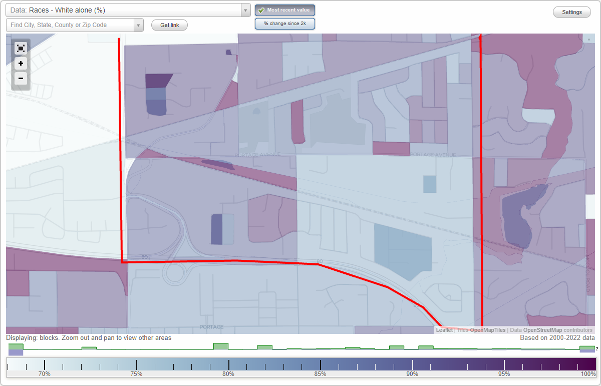
Area: 1.708 square miles
Population: 4,710
Population density:
| Crisman: | 2,757 people per square mile |
| Portage: | 1,482 people per square mile |

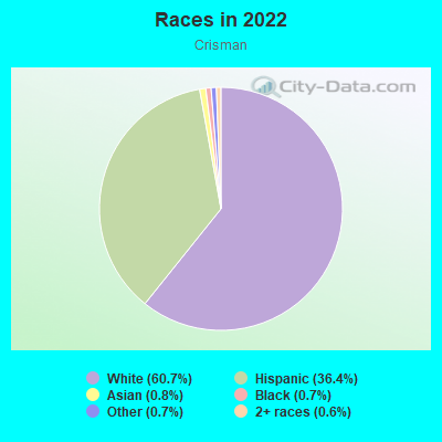
- 2,85960.7%White
- 1,71536.4%Hispanic or Latino
- 390.8%Asian
- 350.7%Black
- 310.7%Some other race
- 290.6%Two or more races
Median household income in 2022:
| Crisman: | $79,208 |
| Portage: | $71,317 |
Distribution of median household income
![Distribution of median household income]()
- 32Less than $10,000
- 40$10,000 to $19,999
- 47$20,000 to $29,999
- 239$30,000 to $39,999
- 246$40,000 to $49,999
- 148$50,000 to $59,999
- 347$60,000 to $74,999
- 512$75,000 to $99,999
- 451$100,000 to $124,999
- 109$125,000 to $149,999
- 95$150,000 to $199,999
- 26$200,000 or more

Distribution of owner-occupied house/condo value
![Distribution of owner-occupied house/condo value]()
- 174Less than $50,000
- 52$50,000 to $99,999
- 524$100,000 to $149,999
- 422$150,000 to $199,999
- 349$200,000 to $249,999
- 144$250,000 to $299,999
- 81$300,000 to $399,999
- 34$500,000 to $749,999
- 27$1,000,000 or more

Distribution of rent paid by renters
![Distribution of rent paid by renters]()
- 14$200 to $299
- 65$400 to $499
- 13$600 to $699
- 11$700 to $799
- 144$800 to $899
- 35$900 to $999
- 65$1,000 to $1,249
- 241$1,250 to $1,499

Median rent in 2022:
| Crisman: | $1,266 |
| Portage: | $876 |
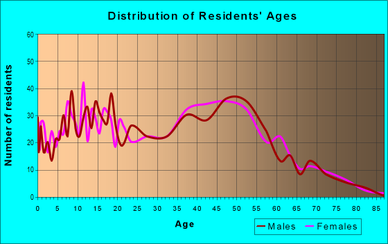
| Males: | 2,528 |
| Females: | 2,181 |
Males:
| This neighborhood: | 52.1 years |
| Whole city: | 38.2 years |
| This neighborhood: | 43.4 years |
| Whole city: | 39.6 years |
Average household size:
| Crisman: | 2.1 people |
| Portage: | 2.5 people |
Percentage of family households:
| Crisman: | 54.8% |
| Portage: | 50.2% |
| Here: | 56.7% |
| Portage: | 47.2% |
Percentage of married-couple families with children (among all households):
| Crisman: | 26.0% |
| Portage: | 24.9% |
Percentage of single-mother households (among all households):
| Crisman: | 16.8% |
| Portage: | 11.3% |
Percentage of never married males 15 years old and over:
Percentage of never married females 15 years old and over:
| Crisman: | 14.0% |
| Portage: | 17.2% |
Percentage of never married females 15 years old and over:
| Crisman: | 13.3% |
| city: | 14.0% |
Percentage of people born in this state:
Percentage of people born in another U.S. state:
Percentage of native residents but born outside the U.S.:
Percentage of foreign born residents:
| Here: | 63.0% |
| Portage: | 69.4% |
Percentage of people born in another U.S. state:
| Crisman: | 30.9% |
| Portage: | 26.4% |
Percentage of native residents but born outside the U.S.:
| Here: | 1.8% |
| city: | 1.0% |
Percentage of foreign born residents:
| Here: | 4.4% |
| Portage: | 3.2% |
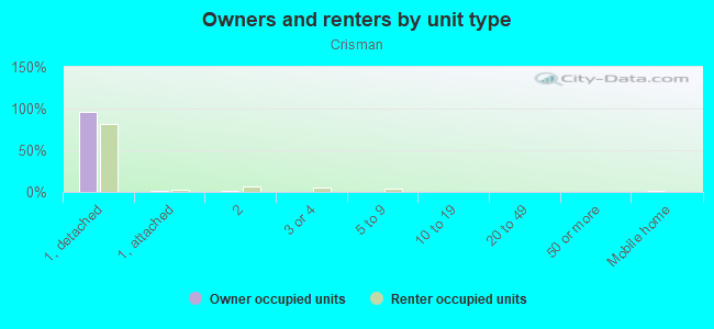
Owner-occupied
Renter-occupied

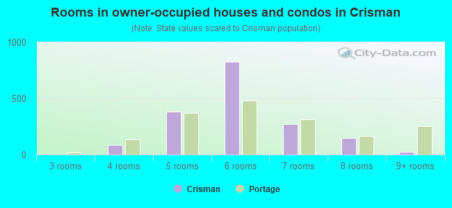
- Rooms in owner-occupied houses and condos in Crisman
- 01 room
- 02 rooms
- 03 rooms
- 864 rooms
- 3825 rooms
- 8296 rooms
- 2717 rooms
- 1478 rooms
- 259+ rooms
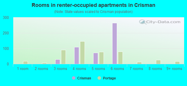
- Rooms in renter-occupied apartments in Crisman
- 01 room
- 02 rooms
- 293 rooms
- 1104 rooms
- 725 rooms
- 2656 rooms
- 07 rooms
- 08 rooms
- 09+ rooms
Owner-occupied
Renter-occupied
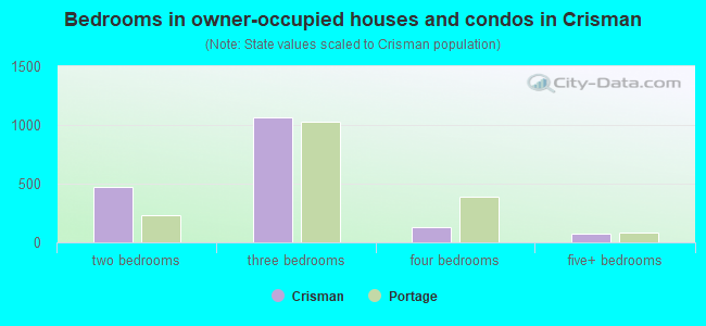
- Bedrooms in owner-occupied houses and condos in Crisman
- 0no bedroom
- 01 bedroom
- 4682 bedrooms
- 1,0653 bedrooms
- 1314 bedrooms
- 765+ bedrooms
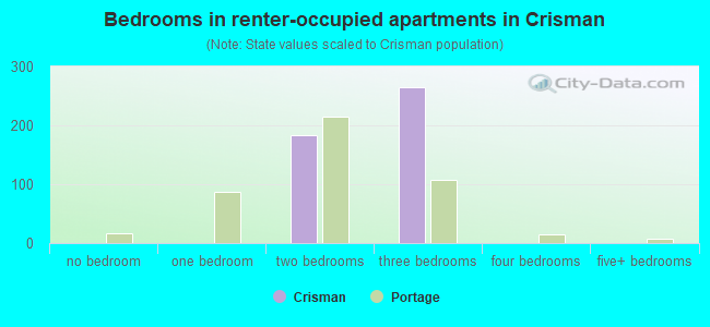
- Bedrooms in renter-occupied apartments in Crisman
- 0no bedroom
- 01 bedroom
- 1832 bedrooms
- 2653 bedrooms
- 04 bedrooms
- 05+ bedrooms
Average number of cars or other vehicles available in houses/condos:
Average number of cars or other vehicles available in apartments:
| This neighborhood: | 2.0 |
| Portage: | 2.1 |
Average number of cars or other vehicles available in apartments:
| Here: | 1.5 |
| city: | 1.4 |
Percentage of units with a mortgage:
| Crisman: | 63.1% |
| Portage: | 64.4% |
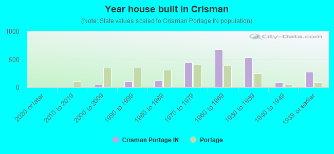
- Year house built in Crisman
- 02020 or later
- 02010 to 2019
- 472000 to 2009
- 1141990 to 1999
- 1191980 to 1989
- 4411970 to 1979
- 6791960 to 1969
- 5351950 to 1959
- 941940 to 1949
- 2791939 or earlier
City-data.com crime index for city in 2020 (higher means more crime):
| City: | 137.1 |
| U.S. average: | 219.5 |
Travel time to work (commute)
![Travel time to work (commute)]()
- 2745 to 9 minutes
- 22210 to 14 minutes
- 33315 to 19 minutes
- 33820 to 24 minutes
- 4025 to 29 minutes
- 60730 to 34 minutes
- 3335 to 39 minutes
- 2940 to 44 minutes
- 17545 to 59 minutes
- 14860 to 89 minutes
- 4690 or more minutes

Means of transportation to work
![Means of transportation to work]()
- 93.7%2,384Drove a car alone
- 3.1%80Carpooled
- 3.3%83Other means
- 3.1%78Worked at home

Time leaving home to go to work
![Time leaving home to go to work]()
- 13812:00 a.m. to 4:59 a.m.
- 535:00 a.m. to 5:29 a.m.
- 1105:30 a.m. to 5:59 a.m.
- 3496:00 a.m. to 6:29 a.m.
- 556:30 a.m. to 6:59 a.m.
- 917:00 a.m. to 7:29 a.m.
- 4017:30 a.m. to 7:59 a.m.
- 1858:00 a.m. to 8:29 a.m.
- 1538:30 a.m. to 8:59 a.m.
- 1189:00 a.m. to 9:59 a.m.
- 2310:00 a.m. to 10:59 a.m.
- 3611:00 a.m. to 11:59 a.m.
- 20412:00 p.m. to 3:59 p.m.
- 2644:00 p.m. to 11:59 p.m.

Occupations of males:
- Percentage of males in management occupations (except farmers):
Here: 8.4% city: 9.1%
- Percentage of males in computer and mathematical occupations:
Here: 1.2% city: 1.8%
- Percentage of males in education, training, and library occupations:
Here: 2.8% city: 1.6%
- Percentage of males in healthcare practitioners and technical occupations:
Here: 7.5% city: 1.9%
- Percentage of males in service occupations:
Here: 13.7% city: 16.1%
- Percentage of males in sales and office occupations:
Here: 8.7% city: 7.2%
- Percentage of males in construction, extraction, and maintenance occupations:
Here: 25.4% city: 9.4%
- Percentage of males in production occupations:
Here: 18.5% city: 13.1%
- Percentage of males in transportation occupations:
Here: 3.5% city: 6.1%
- Percentage of males in material moving occupations:
Here: 3.0% city: 9.9%
Occupations of females:
- Percentage of females in management occupations (except farmers):
Here: 8.9% city: 11.0%
- Percentage of females in community and social services occupations:
Here: 22.7% city: 4.3%
- Percentage of females in legal occupations:
Here: 1.4% city: 1.2%
- Percentage of females in education, training, and library occupations:
Here: 10.2% city: 10.0%
- Percentage of females in healthcare practitioners and technical occupations:
Here: 2.9% city: 8.2%
- Percentage of females in service occupations:
Here: 31.7% city: 17.5%
- Percentage of females in sales and office occupations:
Here: 34.1% city: 29.1%
- Percentage of females in transportation occupations:
Here: 2.6% city: 3.3%
- Percentage of females in material moving occupations:
Here: 4.3% city: 5.8%
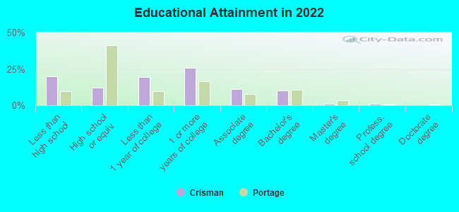
Education in this neighborhood (subdivision or community):
- Percentage of people 3 years and older in K-12 schools:
Crisman: 15.8% Portage: 17.5%
- Percentage of people 3 years and older in undergraduate colleges:
Crisman: 6.1% Portage: 3.5%
- Percentage of people 3 years and older in grad. or professional schools:
Crisman: 0.2% Portage: 0.6%
- Percentage of students K-12 enrolled in private schools:
Crisman: 0.3% Portage: 4.1%
Percentage of population below poverty level:
| Crisman: | 6.8% |
| Portage: | 11.4% |
Median year owner moved in (as recorded in 2022):
Median year renter moved in (as recorded in 2022):
| Crisman: | 2003 |
| Portage: | 2008 |
Median year renter moved in (as recorded in 2022):
| Crisman: | 2019 |
| Portage: | 2016 |
Percentage of married-couple families with both working:
| Crisman: | 135.6% |
| Portage: | 84.7% |
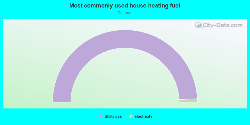
- 98.5%Utility gas
- 1.5%Electricity
Limited-access highways (interstate or state) in this neighborhood:
I- 80 (Indiana East-West Toll Rd, I- 90)
Length: 0.25 miles
Direction: E-W
Direction: E-W
Roads and streets:
Portage Ave
Length: 2.05 miles
Direction: E-W
Address range: 6000 to 6742
Direction: E-W
Address range: 6000 to 6742
Old Porter Rd
Length: 1.94 miles
Direction: E-W
Address range: 6000 to 6703
Direction: E-W
Address range: 6000 to 6703
Indiana East-West Toll Ro (Toll Rd)
Length: 1.90 miles
Directions: E-W, SE-NW
Directions: E-W, SE-NW
Samuelson Rd
Length: 1.27 miles
Direction: N-S
Address range: 2000 to 2599
Direction: N-S
Address range: 2000 to 2599
Lakewood Ave
Length: 1.15 miles
Directions: E-W, SE-NW
Address range: 6200 to 6699
Directions: E-W, SE-NW
Address range: 6200 to 6699
Monument Ave
Length: 1.07 miles
Directions: E-W, SE-NW, SW-NE
Address range: 6300 to 6799
Directions: E-W, SE-NW, SW-NE
Address range: 6300 to 6799
Willowcreek Rd
Length: 0.94 miles
Directions: N-S, SE-NW
Address range: 2100 to 2477
Directions: N-S, SE-NW
Address range: 2100 to 2477
Hamstrom Rd
Length: 0.70 miles
Directions: N-S, SE-NW
Address range: 2200 to 2462
Directions: N-S, SE-NW
Address range: 2200 to 2462
Federal Ave
Length: 0.63 miles
Direction: E-W
Address range: 6100 to 6699
Direction: E-W
Address range: 6100 to 6699
Joseph Ave
Length: 0.46 miles
Directions: E-W, SE-NW, SW-NE
Address range: 6500 to 6699
Directions: E-W, SE-NW, SW-NE
Address range: 6500 to 6699
Valleyview Ave
Length: 0.45 miles
Directions: E-W, N-S
Address range: 6200 to 6498
Directions: E-W, N-S
Address range: 6200 to 6498
Jackson St
Length: 0.44 miles
Direction: N-S
Address range: 2000 to 2299
Direction: N-S
Address range: 2000 to 2299
Venus Ave
Length: 0.43 miles
Directions: E-W, SW-NE
Address range: 6200 to 6499
Directions: E-W, SW-NE
Address range: 6200 to 6499
Crisman Rd
Length: 0.42 miles
Direction: N-S
Address range: 2025 to 2299
Direction: N-S
Address range: 2025 to 2299
Pennsylvania St
Length: 0.38 miles
Directions: E-W, N-S, SE-NW
Address range: 2000 to 2299
Directions: E-W, N-S, SE-NW
Address range: 2000 to 2299
Potomac Ave
Length: 0.36 miles
Directions: E-W, N-S, SW-NE
Address range: 6500 to 6699
Directions: E-W, N-S, SW-NE
Address range: 6500 to 6699
Whippoorwill St
Length: 0.36 miles
Directions: E-W, N-S, SE-NW
Address range: 2000 to 2199
Directions: E-W, N-S, SE-NW
Address range: 2000 to 2199
Kennedy St
Length: 0.35 miles
Directions: N-S, SE-NW
Address range: 2100 to 2299
Directions: N-S, SE-NW
Address range: 2100 to 2299
Blackstone
Length: 0.34 miles
Directions: E-W, N-S, SE-NW, SW-NE
Directions: E-W, N-S, SE-NW, SW-NE
Jefferson St
Length: 0.31 miles
Direction: N-S
Address range: 2000 to 2299
Direction: N-S
Address range: 2000 to 2299
Joseph
Length: 0.31 miles
Directions: E-W, N-S, SE-NW, SW-NE
Address range: 2400 to 2499
Directions: E-W, N-S, SE-NW, SW-NE
Address range: 2400 to 2499
Hamstrom
Length: 0.31 miles
Direction: E-W
Direction: E-W
Hamilton St
Length: 0.30 miles
Direction: N-S
Address range: 2000 to 2299
Direction: N-S
Address range: 2000 to 2299
Vienna Ave
Length: 0.30 miles
Direction: E-W
Address range: 6600 to 6799
Direction: E-W
Address range: 6600 to 6799
Canary Ave
Length: 0.27 miles
Directions: E-W, SE-NW
Address range: 6000 to 6199
Directions: E-W, SE-NW
Address range: 6000 to 6199
Saturn St
Length: 0.27 miles
Directions: N-S, SE-NW, SW-NE
Address range: 2300 to 2499
Directions: N-S, SE-NW, SW-NE
Address range: 2300 to 2499
Michael Dr
Length: 0.26 miles
Directions: E-W, N-S, SE-NW, SW-NE
Directions: E-W, N-S, SE-NW, SW-NE
Hawthorne Ave
Length: 0.25 miles
Direction: E-W
Address range: 6500 to 6699
Direction: E-W
Address range: 6500 to 6699
Capitol St
Length: 0.25 miles
Directions: N-S, SE-NW
Address range: 2100 to 2299
Directions: N-S, SE-NW
Address range: 2100 to 2299
Meadowlark St
Length: 0.25 miles
Direction: E-W
Address range: 6000 to 6099
Direction: E-W
Address range: 6000 to 6099
Venus St
Length: 0.24 miles
Directions: N-S, SE-NW
Address range: 2317 to 2499
Directions: N-S, SE-NW
Address range: 2317 to 2499
Liberty Ave
Length: 0.23 miles
Direction: E-W
Address range: 6600 to 6699
Direction: E-W
Address range: 6600 to 6699
Liberty St
Length: 0.22 miles
Directions: E-W, N-S, SE-NW
Address range: 2100 to 2199
Directions: E-W, N-S, SE-NW
Address range: 2100 to 2199
Stormy St
Length: 0.21 miles
Direction: N-S
Address range: 2100 to 2299
Direction: N-S
Address range: 2100 to 2299
Mockingbird Ave
Length: 0.21 miles
Direction: E-W
Address range: 6000 to 6199
Direction: E-W
Address range: 6000 to 6199
Aloma
Length: 0.20 miles
Directions: E-W, N-S, SE-NW, SW-NE
Directions: E-W, N-S, SE-NW, SW-NE
Bluebird St
Length: 0.20 miles
Directions: N-S, SW-NE
Address range: 2000 to 2199
Directions: N-S, SW-NE
Address range: 2000 to 2199
Norman St
Length: 0.20 miles
Direction: N-S
Address range: 2300 to 2499
Direction: N-S
Address range: 2300 to 2499
Central Ave
Length: 0.19 miles
Direction: E-W
Address range: 6696 to 6757
Direction: E-W
Address range: 6696 to 6757
Jacqueline St
Length: 0.19 miles
Direction: N-S
Address range: 2300 to 2499
Direction: N-S
Address range: 2300 to 2499
Windwood
Length: 0.19 miles
Directions: E-W, N-S, SW-NE
Address range: 2200 to 2299
Directions: E-W, N-S, SW-NE
Address range: 2200 to 2299
Juniper St
Length: 0.18 miles
Direction: N-S
Address range: 2400 to 2499
Direction: N-S
Address range: 2400 to 2499
Doretta St
Length: 0.18 miles
Direction: N-S
Address range: 2300 to 2499
Direction: N-S
Address range: 2300 to 2499
Clover St
Length: 0.17 miles
Direction: N-S
Address range: 2000 to 2099
Direction: N-S
Address range: 2000 to 2099
Magnolia St
Length: 0.17 miles
Direction: N-S
Address range: 2401 to 2499
Direction: N-S
Address range: 2401 to 2499
Rodeo
Length: 0.16 miles
Direction: N-S
Address range: 2200 to 2299
Direction: N-S
Address range: 2200 to 2299
Angel Ln
Length: 0.16 miles
Directions: E-W, N-S, SW-NE
Directions: E-W, N-S, SW-NE
Gaywood Ave
Length: 0.16 miles
Direction: E-W
Address range: 6400 to 6499
Direction: E-W
Address range: 6400 to 6499
Sandwood St
Length: 0.15 miles
Directions: N-S, SW-NE
Address range: 2200 to 2299
Directions: N-S, SW-NE
Address range: 2200 to 2299
Oliver Ave (Oliver St)
Length: 0.15 miles
Direction: E-W
Address range: 6600 to 6799
Direction: E-W
Address range: 6600 to 6799
Eugene Ave (Eugene St)
Length: 0.15 miles
Direction: E-W
Address range: 6600 to 6699
Direction: E-W
Address range: 6600 to 6699
Eastwood St
Length: 0.14 miles
Directions: N-S, SW-NE
Address range: 2300 to 2499
Directions: N-S, SW-NE
Address range: 2300 to 2499
Moss St
Length: 0.14 miles
Direction: N-S
Address range: 2400 to 2499
Direction: N-S
Address range: 2400 to 2499
Center St
Length: 0.14 miles
Directions: N-S, SE-NW
Address range: 2000 to 2099
Directions: N-S, SE-NW
Address range: 2000 to 2099
Steven St
Length: 0.14 miles
Direction: N-S
Address range: 2000 to 2099
Direction: N-S
Address range: 2000 to 2099
McCasland Ave
Length: 0.13 miles
Direction: E-W
Address range: 6000 to 6199
Direction: E-W
Address range: 6000 to 6199
McCasland
Length: 0.12 miles
Direction: E-W
Direction: E-W
Kimdee Ave
Length: 0.12 miles
Direction: E-W
Address range: 62 to 6699
Direction: E-W
Address range: 62 to 6699
Ford Ave (Ford St)
Length: 0.10 miles
Directions: E-W, SW-NE
Address range: 6600 to 6699
Directions: E-W, SW-NE
Address range: 6600 to 6699
Kathryn
Length: 0.10 miles
Directions: E-W, N-S, SE-NW, SW-NE
Directions: E-W, N-S, SE-NW, SW-NE
Venus Ct
Length: 0.09 miles
Direction: E-W
Address range: 2393 to 2419
Direction: E-W
Address range: 2393 to 2419
Lakewood Ct
Length: 0.09 miles
Directions: N-S, SW-NE
Directions: N-S, SW-NE
Dixie Dr
Length: 0.09 miles
Directions: N-S, SE-NW
Address range: 2300 to 2399
Directions: N-S, SE-NW
Address range: 2300 to 2399
Walden Ln
Length: 0.09 miles
Directions: E-W, N-S
Address range: 2200 to 2299
Directions: E-W, N-S
Address range: 2200 to 2299
Madison St
Length: 0.09 miles
Direction: N-S
Address range: 2100 to 2299
Direction: N-S
Address range: 2100 to 2299
Wild Rose Trl
Length: 0.08 miles
Direction: N-S
Address range: 2000 to 2099
Direction: N-S
Address range: 2000 to 2099
Saffron St
Length: 0.08 miles
Direction: N-S
Address range: 2100 to 2199
Direction: N-S
Address range: 2100 to 2199
Trail Run St
Length: 0.07 miles
Direction: N-S
Address range: 2200 to 2299
Direction: N-S
Address range: 2200 to 2299
Trailside
Length: 0.07 miles
Direction: E-W
Direction: E-W
Fifield Ct
Length: 0.07 miles
Direction: E-W
Address range: 6700 to 6799
Direction: E-W
Address range: 6700 to 6799
Railroad
Length: 0.07 miles
Direction: E-W
Address range: 6600 to 6699
Direction: E-W
Address range: 6600 to 6699
Spurr
Length: 0.07 miles
Direction: E-W
Direction: E-W
James Ave
Length: 0.07 miles
Direction: E-W
Address range: 6700 to 6799
Direction: E-W
Address range: 6700 to 6799
Federal Ct
Length: 0.07 miles
Direction: E-W
Direction: E-W
Washington St
Length: 0.06 miles
Direction: N-S
Direction: N-S
Spring St
Length: 0.06 miles
Directions: N-S, SW-NE
Address range: 2300 to 2449
Directions: N-S, SW-NE
Address range: 2300 to 2449
Center Ct
Length: 0.06 miles
Direction: E-W
Address range: 2016 to 2044
Direction: E-W
Address range: 2016 to 2044
Karen St
Length: 0.05 miles
Direction: N-S
Address range: 2000 to 2099
Direction: N-S
Address range: 2000 to 2099
Bluebird Ct
Length: 0.05 miles
Directions: E-W, SE-NW
Address range: 2000 to 2099
Directions: E-W, SE-NW
Address range: 2000 to 2099
Ava Ave
Length: 0.05 miles
Direction: E-W
Direction: E-W
Amarillo St
Length: 0.05 miles
Direction: N-S
Direction: N-S
Grassland Ave
Length: 0.04 miles
Direction: E-W
Direction: E-W
Valley View Ct
Length: 0.04 miles
Direction: N-S
Address range: 6400 to 6432
Direction: N-S
Address range: 6400 to 6432
Kathryn Ct
Length: 0.04 miles
Direction: E-W
Address range: 6200 to 6299
Direction: E-W
Address range: 6200 to 6299
Clover Ct
Length: 0.03 miles
Direction: E-W
Address range: 2001 to 2047
Direction: E-W
Address range: 2001 to 2047
Spruce St
Length: 0.03 miles
Direction: N-S
Address range: 6500 to 6699
Direction: N-S
Address range: 6500 to 6699
Bayou
Length: 0.02 miles
Direction: E-W
Direction: E-W
Railroad features:
Baltimore and Ohio RR
Length: 2.12 miles
Direction: E-W
Direction: E-W
New York Central RR
Length: 2.10 miles
Direction: E-W
Direction: E-W
Other features:
Willow Crk
Length: 0.42 miles
Directions: E-W, N-S, SE-NW, SW-NE
Directions: E-W, N-S, SE-NW, SW-NE