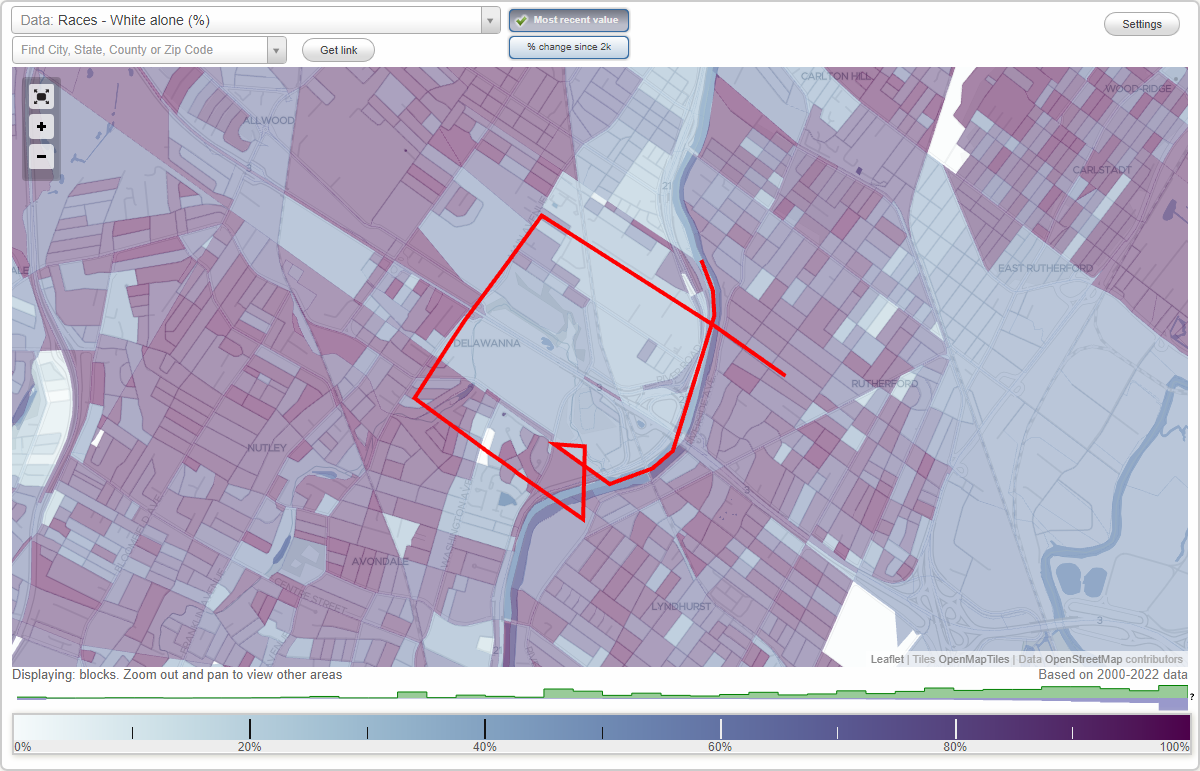
Delawanna neighborhood in Clifton, New Jersey (NJ), 07012, 07014 detailed profile
Settings
X

Business Search - 14 Million verified businesses
Area: 1.645 square miles
Population: 5,519
Population density:
| Delawanna: | 3,355 people per square mile |
| Clifton: | 7,855 people per square mile |

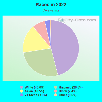
- 3,16446.0%White
- 1,82226.5%Hispanic or Latino
- 1,13616.5%Asian
- 5067.4%Black
- 2073.0%Two or more races
- 390.6%Some other race
Median household income in 2022:
| Delawanna: | $139,632 |
| Clifton: | $95,147 |
Distribution of median household income
![Distribution of median household income]()
- 104Less than $10,000
- 211$10,000 to $19,999
- 394$20,000 to $29,999
- 228$30,000 to $39,999
- 283$40,000 to $49,999
- 339$50,000 to $59,999
- 298$60,000 to $74,999
- 178$75,000 to $99,999
- 164$100,000 to $124,999
- 292$125,000 to $149,999
- 252$150,000 to $199,999
- 495$200,000 or more

Distribution of owner-occupied house/condo value
![Distribution of owner-occupied house/condo value]()
- 333Less than $50,000
- 1,139$50,000 to $99,999
- 142$100,000 to $149,999
- 302$150,000 to $199,999
- 133$200,000 to $249,999
- 112$250,000 to $299,999
- 635$300,000 to $399,999
- 383$400,000 to $499,999
- 429$500,000 to $749,999
- 134$750,000 to $999,999
- 232$1,000,000 or more

Distribution of rent paid by renters
![Distribution of rent paid by renters]()
- 97$300 to $399
- 59$400 to $499
- 139$500 to $599
- 83$800 to $899
- 294$900 to $999
- 315$1,000 to $1,249
- 229$1,250 to $1,499
- 133$1,500 to $1,999
- 1,147$2,000 or more

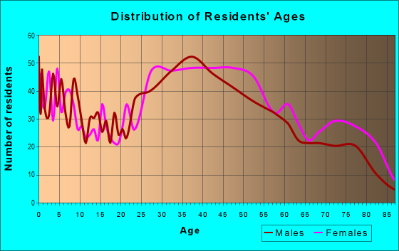
| Males: | 2,795 |
| Females: | 2,723 |
Males:
| This neighborhood: | 40.0 years |
| Whole city: | 39.2 years |
| This neighborhood: | 44.1 years |
| Whole city: | 40.5 years |
Average household size:
| Delawanna: | 2.6 people |
| Clifton: | 2.5 people |
Percentage of family households:
| Delawanna: | 43.5% |
| Clifton: | 45.4% |
| Here: | 57.9% |
| Clifton: | 46.6% |
Percentage of married-couple families with children (among all households):
| Delawanna: | 36.0% |
| Clifton: | 30.6% |
Percentage of single-mother households (among all households):
| Delawanna: | 7.4% |
| Clifton: | 5.7% |
Percentage of never married males 15 years old and over:
Percentage of never married females 15 years old and over:
| Delawanna: | 16.3% |
| Clifton: | 18.6% |
Percentage of never married females 15 years old and over:
| Delawanna: | 14.3% |
| city: | 16.0% |
Percentage of people that speak English not well or not at all:
| Delawanna: | 10.8% |
| Clifton: | 8.4% |
Percentage of people born in this state:
Percentage of people born in another U.S. state:
Percentage of native residents but born outside the U.S.:
Percentage of foreign born residents:
| Here: | 33.6% |
| Clifton: | 47.6% |
Percentage of people born in another U.S. state:
| Delawanna: | 25.6% |
| Clifton: | 14.4% |
Percentage of native residents but born outside the U.S.:
| Here: | 4.8% |
| city: | 4.9% |
Percentage of foreign born residents:
| Here: | 36.0% |
| Clifton: | 33.1% |
Owner-occupied
Renter-occupied

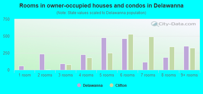
- Rooms in owner-occupied houses and condos in Delawanna
- 581 room
- 2352 rooms
- 923 rooms
- 2264 rooms
- 4755 rooms
- 4656 rooms
- 1177 rooms
- 1878 rooms
- 3509+ rooms
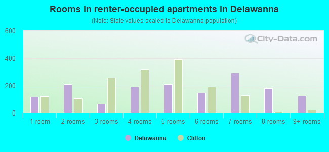
- Rooms in renter-occupied apartments in Delawanna
- 1171 room
- 2122 rooms
- 673 rooms
- 1944 rooms
- 2115 rooms
- 1486 rooms
- 2937 rooms
- 1818 rooms
- 1259+ rooms
Owner-occupied
Renter-occupied
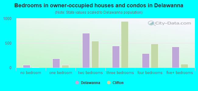
- Bedrooms in owner-occupied houses and condos in Delawanna
- 58no bedroom
- 1851 bedroom
- 7012 bedrooms
- 4453 bedrooms
- 2934 bedrooms
- 4245+ bedrooms
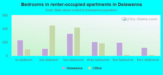
- Bedrooms in renter-occupied apartments in Delawanna
- 235no bedroom
- 1061 bedroom
- 3282 bedrooms
- 2083 bedrooms
- 1984 bedrooms
- 1235+ bedrooms
Average number of cars or other vehicles available in houses/condos:
Average number of cars or other vehicles available in apartments:
| This neighborhood: | 1.5 |
| Clifton: | 2.0 |
Average number of cars or other vehicles available in apartments:
| Here: | 2.0 |
| city: | 1.1 |
Percentage of units with a mortgage:
| Delawanna: | 55.9% |
| Clifton: | 62.1% |
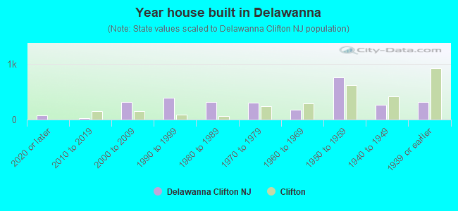
- Year house built in Delawanna
- 802020 or later
- 242010 to 2019
- 3112000 to 2009
- 3931990 to 1999
- 3101980 to 1989
- 3011970 to 1979
- 1801960 to 1969
- 7621950 to 1959
- 2631940 to 1949
- 3191939 or earlier
City-data.com crime index for city in 2020 (higher means more crime):
| City: | 98.9 |
| U.S. average: | 219.5 |
Travel time to work (commute)
![Travel time to work (commute)]()
- 52Less than 5 minutes
- 1885 to 9 minutes
- 22210 to 14 minutes
- 13815 to 19 minutes
- 35320 to 24 minutes
- 19325 to 29 minutes
- 44030 to 34 minutes
- 19035 to 39 minutes
- 32140 to 44 minutes
- 26045 to 59 minutes
- 12960 to 89 minutes
- 4990 or more minutes

Means of transportation to work
![Means of transportation to work]()
- 76.8%2,170Drove a car alone
- 9.7%273Carpooled
- 5.3%149Bus
- 0.8%24Subway or elevated rail
- 5.6%157Long-distance train or commuter rail
- 2.7%75Light rail, streetcar or trolley
- 2.0%57Taxi
- 1.3%36Bicycle
- 0.5%14Walked
- 4.5%128Other means
- 3.0%85Worked at home

Time leaving home to go to work
![Time leaving home to go to work]()
- 8712:00 a.m. to 4:59 a.m.
- 295:00 a.m. to 5:29 a.m.
- 1205:30 a.m. to 5:59 a.m.
- 2486:00 a.m. to 6:29 a.m.
- 2546:30 a.m. to 6:59 a.m.
- 1887:00 a.m. to 7:29 a.m.
- 4177:30 a.m. to 7:59 a.m.
- 2898:00 a.m. to 8:29 a.m.
- 3188:30 a.m. to 8:59 a.m.
- 2589:00 a.m. to 9:59 a.m.
- 7410:00 a.m. to 10:59 a.m.
- 5911:00 a.m. to 11:59 a.m.
- 14412:00 p.m. to 3:59 p.m.
- 1104:00 p.m. to 11:59 p.m.

Occupations of males:
- Percentage of males in management occupations (except farmers):
Here: 13.3% city: 11.9%
- Percentage of males in business and financial operations occupations:
Here: 11.6% city: 5.1%
- Percentage of males in computer and mathematical occupations:
Here: 3.1% city: 4.7%
- Percentage of males in architecture and engineering occupations:
Here: 1.8% city: 4.0%
- Percentage of males in education, training, and library occupations:
Here: 9.3% city: 3.9%
- Percentage of males in healthcare practitioners and technical occupations:
Here: 5.1% city: 2.7%
- Percentage of males in service occupations:
Here: 12.3% city: 12.4%
- Percentage of males in sales and office occupations:
Here: 15.3% city: 15.0%
- Percentage of males in farming, fishing, and forestry occupations:
Here: 2.0% city: 0.2%
- Percentage of males in construction, extraction, and maintenance occupations:
Here: 8.3% city: 6.5%
- Percentage of males in production occupations:
Here: 9.4% city: 9.1%
- Percentage of males in transportation occupations:
Here: 2.7% city: 8.9%
- Percentage of males in material moving occupations:
Here: 2.9% city: 4.3%
Occupations of females:
- Percentage of females in management occupations (except farmers):
Here: 7.2% city: 8.6%
- Percentage of females in business and financial operations occupations:
Here: 11.0% city: 7.8%
- Percentage of females in computer and mathematical occupations:
Here: 2.0% city: 1.1%
- Percentage of females in architecture and engineering occupations:
Here: 1.3% city: 1.3%
- Percentage of females in legal occupations:
Here: 1.5% city: 1.7%
- Percentage of females in education, training, and library occupations:
Here: 15.7% city: 9.8%
- Percentage of females in arts, design, entertainment, sports, and media occupations:
Here: 3.1% city: 2.1%
- Percentage of females in healthcare practitioners and technical occupations:
Here: 7.4% city: 8.5%
- Percentage of females in service occupations:
Here: 24.1% city: 17.9%
- Percentage of females in sales and office occupations:
Here: 13.7% city: 28.5%
- Percentage of females in production occupations:
Here: 9.6% city: 5.5%
- Percentage of females in transportation occupations:
Here: 2.7% city: 1.1%
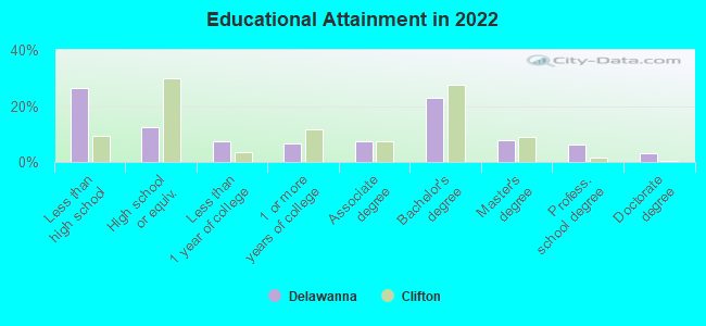
Education in this neighborhood (subdivision or community):
- Percentage of people 3 years and older in K-12 schools:
Delawanna: 37.4% Clifton: 14.4%
- Percentage of people 3 years and older in undergraduate colleges:
Delawanna: 5.4% Clifton: 6.2%
- Percentage of people 3 years and older in grad. or professional schools:
Delawanna: 3.8% Clifton: 2.0%
- Percentage of students K-12 enrolled in private schools:
Delawanna: 59.2% Clifton: 20.0%
Percentage of population below poverty level:
| Delawanna: | 4.6% |
| Clifton: | 5.4% |
Median year owner moved in (as recorded in 2022):
| Delawanna: | 2006 |
| Clifton: | 2009 |
Percentage of married-couple families with both working:
| Delawanna: | 175.2% |
| Clifton: | 72.6% |
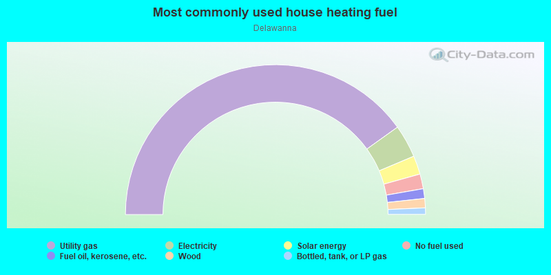
- 80.2%Utility gas
- 7.1%Electricity
- 4.0%Solar energy
- 3.2%No fuel used
- 2.1%Fuel oil, kerosene, etc.
- 2.0%Wood
- 1.4%Bottled, tank, or LP gas
Roads and streets:
Robert St
Length: 0.09 miles
Direction: SE-NW
Address range: 1 to 23
Direction: SE-NW
Address range: 1 to 23
River Rd
Length: 0.00 miles
Direction: N-S
Address range: 529 to 532
Direction: N-S
Address range: 529 to 532
Highways in this neighborhood:
State Rte 3
Length: 3.96 miles
Direction: SE-NW
Address range: 1 to 620
Direction: SE-NW
Address range: 1 to 620
State Rte 21
Length: 2.81 miles
Directions: E-W, N-S, SE-NW, SW-NE
Directions: E-W, N-S, SE-NW, SW-NE
Roads and streets:
River Rd
Length: 1.62 miles
Directions: E-W, N-S, SE-NW, SW-NE
Address range: 1 to 592
Directions: E-W, N-S, SE-NW, SW-NE
Address range: 1 to 592
South Pkwy
Length: 1.34 miles
Directions: E-W, SE-NW
Address range: 53 to 498
Directions: E-W, SE-NW
Address range: 53 to 498
Main Ave (Passaic County 601)
Length: 1.14 miles
Direction: SW-NE
Address range: 1 to 499
Direction: SW-NE
Address range: 1 to 499
Delawanna Ave
Length: 1.13 miles
Direction: SE-NW
Address range: 2 to 398
Direction: SE-NW
Address range: 2 to 398
Rutherford Blvd
Length: 1.04 miles
Direction: SE-NW
Address range: 72 to 453
Direction: SE-NW
Address range: 72 to 453
Passaic Ave
Length: 0.99 miles
Direction: SW-NE
Address range: 539 to 799
Direction: SW-NE
Address range: 539 to 799
Passaic County 602 (Allwood Rd)
Length: 0.74 miles
Directions: E-W, SE-NW
Address range: 23 to 881
Directions: E-W, SE-NW
Address range: 23 to 881
Fenlon Blvd
Length: 0.72 miles
Directions: E-W, N-S, SE-NW, SW-NE
Address range: 334 to 610
Directions: E-W, N-S, SE-NW, SW-NE
Address range: 334 to 610
Entin Rd
Length: 0.63 miles
Directions: E-W, SE-NW, SW-NE
Address range: 1 to 232
Directions: E-W, SE-NW, SW-NE
Address range: 1 to 232
Kingsland Rd
Length: 0.60 miles
Directions: E-W, SE-NW
Address range: 1 to 184
Directions: E-W, SE-NW
Address range: 1 to 184
Patricia Pl
Length: 0.59 miles
Directions: E-W, N-S, SE-NW, SW-NE
Address range: 1 to 207
Directions: E-W, N-S, SE-NW, SW-NE
Address range: 1 to 207
Myrtle Ave
Length: 0.57 miles
Directions: N-S, SE-NW, SW-NE
Address range: 1 to 99
Directions: N-S, SE-NW, SW-NE
Address range: 1 to 99
William St
Length: 0.51 miles
Directions: E-W, SE-NW
Address range: 1 to 156
Directions: E-W, SE-NW
Address range: 1 to 156
Princeton St
Length: 0.47 miles
Directions: E-W, SE-NW
Address range: 1 to 166
Directions: E-W, SE-NW
Address range: 1 to 166
Dwasline Rd (Dwas Line Rd)
Length: 0.46 miles
Directions: N-S, SW-NE
Address range: 404 to 426
Directions: N-S, SW-NE
Address range: 404 to 426
Kingsland Ave
Length: 0.38 miles
Directions: E-W, N-S, SE-NW, SW-NE
Address range: 1 to 199
Directions: E-W, N-S, SE-NW, SW-NE
Address range: 1 to 199
Water St
Length: 0.37 miles
Direction: SE-NW
Direction: SE-NW
Ward Ave
Length: 0.35 miles
Direction: SE-NW
Address range: 1 to 99
Direction: SE-NW
Address range: 1 to 99
Oak St
Length: 0.34 miles
Directions: N-S, SW-NE
Address range: 1 to 137
Directions: N-S, SW-NE
Address range: 1 to 137
Linden Ave
Length: 0.33 miles
Directions: SE-NW, SW-NE
Address range: 1 to 119
Directions: SE-NW, SW-NE
Address range: 1 to 119
Bridewell Pl
Length: 0.33 miles
Direction: SE-NW
Address range: 2 to 24
Direction: SE-NW
Address range: 2 to 24
Cherry St
Length: 0.30 miles
Directions: N-S, SE-NW, SW-NE
Address range: 13 to 137
Directions: N-S, SE-NW, SW-NE
Address range: 13 to 137
Ardmore Ave
Length: 0.26 miles
Direction: SW-NE
Address range: 1 to 99
Direction: SW-NE
Address range: 1 to 99
Davan Rd
Length: 0.23 miles
Directions: N-S, SE-NW
Address range: 58 to 66
Directions: N-S, SE-NW
Address range: 58 to 66
Lorrie Ln
Length: 0.23 miles
Directions: E-W, SE-NW, SW-NE
Address range: 1 to 76
Directions: E-W, SE-NW, SW-NE
Address range: 1 to 76
Paterson Ave
Length: 0.23 miles
Direction: SW-NE
Address range: 1 to 99
Direction: SW-NE
Address range: 1 to 99
Lehigh Ave
Length: 0.23 miles
Direction: SE-NW
Address range: 1 to 75
Direction: SE-NW
Address range: 1 to 75
Belmont Ave
Length: 0.23 miles
Direction: SE-NW
Address range: 1 to 80
Direction: SE-NW
Address range: 1 to 80
Lenox Ave
Length: 0.23 miles
Direction: SE-NW
Address range: 1 to 79
Direction: SE-NW
Address range: 1 to 79
High St
Length: 0.23 miles
Direction: SW-NE
Address range: 1 to 99
Direction: SW-NE
Address range: 1 to 99
Hollywood Ave
Length: 0.20 miles
Direction: SW-NE
Address range: 1 to 99
Direction: SW-NE
Address range: 1 to 99
River Dr
Length: 0.20 miles
Direction: SE-NW
Direction: SE-NW
Frances St
Length: 0.20 miles
Directions: N-S, SE-NW, SW-NE
Address range: 2 to 64
Directions: N-S, SE-NW, SW-NE
Address range: 2 to 64
Myron St
Length: 0.19 miles
Direction: SE-NW
Address range: 1 to 65
Direction: SE-NW
Address range: 1 to 65
Homer St
Length: 0.19 miles
Direction: SE-NW
Address range: 1 to 61
Direction: SE-NW
Address range: 1 to 61
Dyer Ave
Length: 0.19 miles
Directions: E-W, N-S, SE-NW, SW-NE
Address range: 44 to 104
Directions: E-W, N-S, SE-NW, SW-NE
Address range: 44 to 104
Annabelle Ave
Length: 0.18 miles
Direction: SW-NE
Address range: 1 to 69
Direction: SW-NE
Address range: 1 to 69
Kensington Ave
Length: 0.18 miles
Direction: SW-NE
Address range: 1 to 99
Direction: SW-NE
Address range: 1 to 99
Hall St
Length: 0.17 miles
Direction: SW-NE
Address range: 1 to 73
Direction: SW-NE
Address range: 1 to 73
Ruth Ave
Length: 0.17 miles
Direction: SW-NE
Address range: 1 to 64
Direction: SW-NE
Address range: 1 to 64
Lois Ave
Length: 0.16 miles
Direction: SW-NE
Address range: 1 to 58
Direction: SW-NE
Address range: 1 to 58
Princeton Pl
Length: 0.16 miles
Directions: SE-NW, SW-NE
Address range: 1 to 64
Directions: SE-NW, SW-NE
Address range: 1 to 64
Evergreen Dr
Length: 0.16 miles
Directions: E-W, SE-NW, SW-NE
Address range: 2 to 99
Directions: E-W, SE-NW, SW-NE
Address range: 2 to 99
Autumn St
Length: 0.15 miles
Directions: E-W, SE-NW, SW-NE
Address range: 1 to 44
Directions: E-W, SE-NW, SW-NE
Address range: 1 to 44
Robert St
Length: 0.15 miles
Directions: SE-NW, SW-NE
Address range: 1 to 23
Directions: SE-NW, SW-NE
Address range: 1 to 23
Jefferson St
Length: 0.14 miles
Direction: SW-NE
Address range: 1 to 66
Direction: SW-NE
Address range: 1 to 66
Carol St
Length: 0.14 miles
Direction: SW-NE
Address range: 1 to 50
Direction: SW-NE
Address range: 1 to 50
Century Dr
Length: 0.13 miles
Direction: SE-NW
Direction: SE-NW
Timber Dr
Length: 0.13 miles
Directions: N-S, SE-NW
Address range: 1 to 99
Directions: N-S, SE-NW
Address range: 1 to 99
West Pkwy
Length: 0.13 miles
Directions: N-S, SW-NE
Address range: 1 to 52
Directions: N-S, SW-NE
Address range: 1 to 52
Cathedral Ave
Length: 0.12 miles
Direction: SW-NE
Address range: 67 to 99
Direction: SW-NE
Address range: 67 to 99
Peekay Dr
Length: 0.12 miles
Direction: SW-NE
Address range: 1 to 99
Direction: SW-NE
Address range: 1 to 99
Pennington Ave
Length: 0.12 miles
Direction: SW-NE
Address range: 28 to 38
Direction: SW-NE
Address range: 28 to 38
Johnson St
Length: 0.12 miles
Direction: SW-NE
Address range: 1 to 65
Direction: SW-NE
Address range: 1 to 65
Park Ave
Length: 0.11 miles
Directions: N-S, SE-NW, SW-NE
Address range: 282 to 299
Directions: N-S, SE-NW, SW-NE
Address range: 282 to 299
Hughes St
Length: 0.11 miles
Direction: SW-NE
Address range: 16 to 32
Direction: SW-NE
Address range: 16 to 32
Essex St
Length: 0.11 miles
Directions: N-S, SW-NE
Address range: 1 to 76
Directions: N-S, SW-NE
Address range: 1 to 76
Wicker St
Length: 0.11 miles
Direction: SW-NE
Address range: 1 to 32
Direction: SW-NE
Address range: 1 to 32
Wheeler St
Length: 0.11 miles
Direction: SW-NE
Address range: 1 to 30
Direction: SW-NE
Address range: 1 to 30
Spruce Ct
Length: 0.10 miles
Directions: N-S, SE-NW, SW-NE
Address range: 1 to 99
Directions: N-S, SE-NW, SW-NE
Address range: 1 to 99
Swift Ct
Length: 0.10 miles
Direction: SE-NW
Address range: 1 to 36
Direction: SE-NW
Address range: 1 to 36
Boll St
Length: 0.10 miles
Direction: SW-NE
Address range: 67 to 103
Direction: SW-NE
Address range: 67 to 103
Colin Ave
Length: 0.10 miles
Direction: SW-NE
Address range: 47 to 99
Direction: SW-NE
Address range: 47 to 99
Ringsland Ave
Length: 0.10 miles
Directions: E-W, N-S, SE-NW
Directions: E-W, N-S, SE-NW
Colorado St
Length: 0.10 miles
Direction: SW-NE
Direction: SW-NE
Conover Pl (Conover Ct)
Length: 0.09 miles
Direction: SW-NE
Address range: 1 to 99
Direction: SW-NE
Address range: 1 to 99
Filmore St
Length: 0.08 miles
Direction: SW-NE
Address range: 40 to 42
Direction: SW-NE
Address range: 40 to 42
Toth Ct
Length: 0.08 miles
Direction: SE-NW
Address range: 1 to 27
Direction: SE-NW
Address range: 1 to 27
Juniper Ct
Length: 0.08 miles
Directions: SE-NW, SW-NE
Address range: 1 to 99
Directions: SE-NW, SW-NE
Address range: 1 to 99
Clay St
Length: 0.08 miles
Direction: SE-NW
Address range: 1 to 25
Direction: SE-NW
Address range: 1 to 25
Nettie Pl
Length: 0.08 miles
Direction: SW-NE
Address range: 1 to 30
Direction: SW-NE
Address range: 1 to 30
Evergreen Condos
Length: 0.07 miles
Direction: SE-NW
Direction: SE-NW
East Pkwy
Length: 0.07 miles
Direction: SW-NE
Address range: 1 to 26
Direction: SW-NE
Address range: 1 to 26
Balsam Ct
Length: 0.06 miles
Direction: SW-NE
Address range: 2 to 99
Direction: SW-NE
Address range: 2 to 99
Cedar Pl
Length: 0.06 miles
Direction: SW-NE
Direction: SW-NE
Beech St
Length: 0.06 miles
Direction: SW-NE
Address range: 1 to 10
Direction: SW-NE
Address range: 1 to 10
Stanchak Ct
Length: 0.06 miles
Direction: SW-NE
Address range: 1 to 23
Direction: SW-NE
Address range: 1 to 23
Wanda Ct
Length: 0.05 miles
Directions: N-S, SE-NW, SW-NE
Address range: 1 to 99
Directions: N-S, SE-NW, SW-NE
Address range: 1 to 99
Pine St
Length: 0.05 miles
Direction: SW-NE
Direction: SW-NE
Blanjen Ter
Length: 0.05 miles
Direction: SW-NE
Address range: 1 to 20
Direction: SW-NE
Address range: 1 to 20
Austin Pl
Length: 0.05 miles
Direction: SW-NE
Address range: 3 to 99
Direction: SW-NE
Address range: 3 to 99
Terrace Ave
Length: 0.05 miles
Direction: SW-NE
Address range: 60 to 76
Direction: SW-NE
Address range: 60 to 76
Walnut St
Length: 0.04 miles
Direction: SW-NE
Direction: SW-NE
Riverwalk Way (Pebble Brook Dr)
Length: 0.04 miles
Direction: SE-NW
Address range: 100 to 294
Direction: SE-NW
Address range: 100 to 294
Hillsdale Ave
Length: 0.04 miles
Direction: SW-NE
Address range: 400 to 430
Direction: SW-NE
Address range: 400 to 430
Cambridge Ct
Length: 0.03 miles
Direction: SE-NW
Address range: 100 to 246
Direction: SE-NW
Address range: 100 to 246
Anton St
Length: 0.03 miles
Direction: SW-NE
Address range: 12 to 17
Direction: SW-NE
Address range: 12 to 17
Raymond Pl
Length: 0.03 miles
Direction: SE-NW
Address range: 1 to 99
Direction: SE-NW
Address range: 1 to 99
Pavan Ave
Length: 0.02 miles
Direction: N-S
Direction: N-S
Railroad features:
Conrail RR
Length: 1.38 miles
Directions: N-S, SE-NW
Directions: N-S, SE-NW
Other features:
3rd Riv
Length: 0.80 miles
Directions: E-W, N-S, SE-NW, SW-NE
Directions: E-W, N-S, SE-NW, SW-NE
Yantacaw Riv
Length: 0.48 miles
Directions: E-W, N-S, SE-NW, SW-NE
Directions: E-W, N-S, SE-NW, SW-NE