East Springfield neighborhood in Springfield, Massachusetts (MA), 01104 detailed profile
Settings
X


Business Search - 14 Million verified businesses
Area: 2.918 square miles
Population: 6,059
Population density:
| East Springfield: | 2,076 people per square mile |
| Springfield: | 4,799 people per square mile |

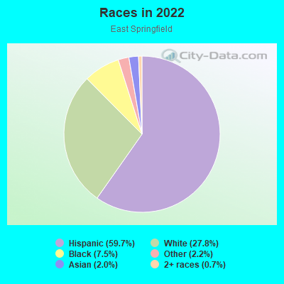
- 3,76959.7%Hispanic or Latino
- 1,75627.8%White
- 4757.5%Black
- 1362.2%Some other race
- 1262.0%Asian
- 440.7%Two or more races
- 50.08%American Indian
Distribution of median household income
![Distribution of median household income]()
- 153Less than $10,000
- 141$10,000 to $19,999
- 233$20,000 to $29,999
- 364$30,000 to $39,999
- 272$40,000 to $49,999
- 176$50,000 to $59,999
- 325$60,000 to $74,999
- 266$75,000 to $99,999
- 140$100,000 to $124,999
- 223$125,000 to $149,999
- 474$150,000 to $199,999
- 472$200,000 or more

Distribution of owner-occupied house/condo value
![Distribution of owner-occupied house/condo value]()
- 381Less than $50,000
- 482$50,000 to $99,999
- 335$100,000 to $149,999
- 1,009$150,000 to $199,999
- 311$200,000 to $249,999
- 74$250,000 to $299,999
- 147$300,000 to $399,999
- 42$400,000 to $499,999
- 114$500,000 to $749,999
- 23$1,000,000 or more

Distribution of rent paid by renters
![Distribution of rent paid by renters]()
- 536Less than $100
- 73$100 to $199
- 173$200 to $299
- 139$300 to $399
- 240$400 to $499
- 1,132$500 to $599
- 78$600 to $699
- 585$700 to $799
- 81$800 to $899
- 80$900 to $999
- 239$1,000 to $1,249
- 42$1,250 to $1,499
- 221$1,500 to $1,999
- 16$2,000 or more

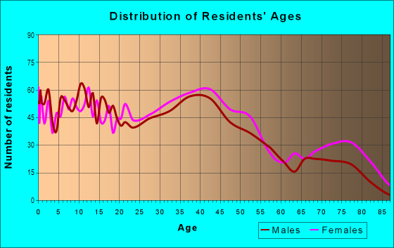
| Males: | 2,381 |
| Females: | 3,677 |
Males:
| This neighborhood: | 42.5 years |
| Whole city: | 31.4 years |
| This neighborhood: | 42.9 years |
| Whole city: | 35.8 years |
Average household size:
| East Springfield: | 2.5 people |
| Springfield: | 2.5 people |
Percentage of family households:
| East Springfield: | 47.3% |
| Springfield: | 44.9% |
| Here: | 35.0% |
| Springfield: | 30.7% |
Percentage of married-couple families with children (among all households):
| East Springfield: | 12.7% |
| Springfield: | 16.3% |
Percentage of single-mother households (among all households):
| East Springfield: | 30.0% |
| Springfield: | 18.7% |
Percentage of never married males 15 years old and over:
Percentage of never married females 15 years old and over:
| East Springfield: | 16.3% |
| Springfield: | 26.1% |
Percentage of never married females 15 years old and over:
| East Springfield: | 22.3% |
| city: | 26.9% |
Percentage of people that speak English not well or not at all:
| East Springfield: | 5.6% |
| Springfield: | 9.6% |
Percentage of people born in this state:
Percentage of people born in another U.S. state:
Percentage of native residents but born outside the U.S.:
Percentage of foreign born residents:
| Here: | 59.0% |
| Springfield: | 51.3% |
Percentage of people born in another U.S. state:
| East Springfield: | 10.8% |
| Springfield: | 19.5% |
Percentage of native residents but born outside the U.S.:
| Here: | 21.1% |
| city: | 17.4% |
Percentage of foreign born residents:
| Here: | 9.1% |
| Springfield: | 11.9% |
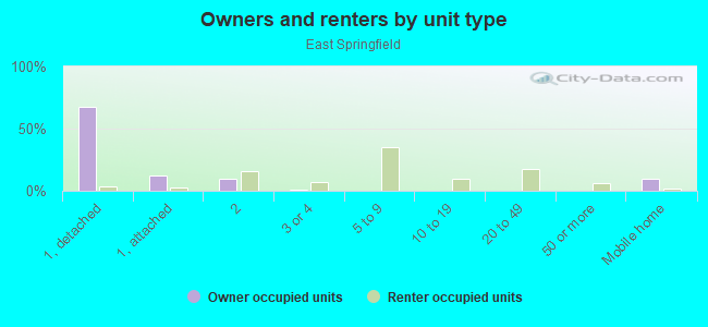
Owner-occupied
Renter-occupied

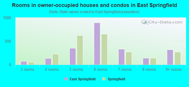
- Rooms in owner-occupied houses and condos in East Springfield
- 01 room
- 02 rooms
- 763 rooms
- 1374 rooms
- 3505 rooms
- 8966 rooms
- 3357 rooms
- 1398 rooms
- 3219+ rooms
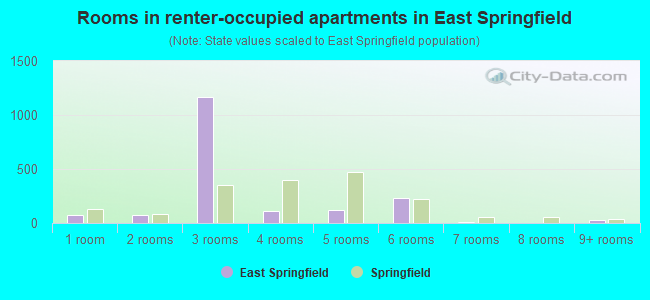
- Rooms in renter-occupied apartments in East Springfield
- 741 room
- 712 rooms
- 1,1693 rooms
- 1104 rooms
- 1225 rooms
- 2296 rooms
- 87 rooms
- 18 rooms
- 279+ rooms
Owner-occupied
Renter-occupied
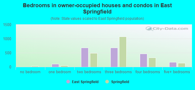
- Bedrooms in owner-occupied houses and condos in East Springfield
- 0no bedroom
- 1021 bedroom
- 6862 bedrooms
- 6853 bedrooms
- 4734 bedrooms
- 1725+ bedrooms
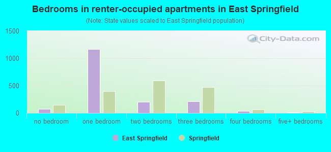
- Bedrooms in renter-occupied apartments in East Springfield
- 74no bedroom
- 1,1691 bedroom
- 2062 bedrooms
- 2113 bedrooms
- 334 bedrooms
- 65+ bedrooms
Average number of cars or other vehicles available in houses/condos:
Average number of cars or other vehicles available in apartments:
| This neighborhood: | 0.5 |
| Springfield: | 1.7 |
Average number of cars or other vehicles available in apartments:
| Here: | 0.4 |
| city: | 0.9 |
Percentage of units with a mortgage:
| East Springfield: | 68.8% |
| Springfield: | 70.5% |
Housing prices:
- Average estimated value of detached houses in 2022 (65.9% of all units):
East Springfield: $194,856 Springfield: $262,257
- Average estimated value of mobile home in 2022 (9.4% of all units):
East Springfield: $83,843 Springfield: $98,268
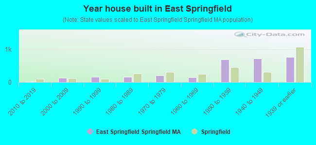
- Year house built in East Springfield
- 02020 or later
- 102010 to 2019
- 1322000 to 2009
- 1611990 to 1999
- 1591980 to 1989
- 2081970 to 1979
- 1481960 to 1969
- 6801950 to 1959
- 7191940 to 1949
- 7581939 or earlier
City-data.com crime index for city in 2020 (higher means more crime):
| City: | 387.4 |
| U.S. average: | 219.5 |
Travel time to work (commute)
![Travel time to work (commute)]()
- 201Less than 5 minutes
- 3495 to 9 minutes
- 79710 to 14 minutes
- 78715 to 19 minutes
- 45120 to 24 minutes
- 17125 to 29 minutes
- 28730 to 34 minutes
- 15935 to 39 minutes
- 19640 to 44 minutes
- 17345 to 59 minutes
- 10560 to 89 minutes
- 2990 or more minutes

Means of transportation to work
![Means of transportation to work]()
- 83.4%2,458Drove a car alone
- 6.3%186Carpooled
- 1.0%30Bus
- 2.2%65Walked
- 25.4%750Other means
- 7.4%219Worked at home

Time leaving home to go to work
![Time leaving home to go to work]()
- 6812:00 a.m. to 4:59 a.m.
- 925:00 a.m. to 5:29 a.m.
- 1585:30 a.m. to 5:59 a.m.
- 1396:00 a.m. to 6:29 a.m.
- 4146:30 a.m. to 6:59 a.m.
- 3697:00 a.m. to 7:29 a.m.
- 4467:30 a.m. to 7:59 a.m.
- 5678:00 a.m. to 8:29 a.m.
- 2708:30 a.m. to 8:59 a.m.
- 1619:00 a.m. to 9:59 a.m.
- 12410:00 a.m. to 10:59 a.m.
- 2211:00 a.m. to 11:59 a.m.
- 32512:00 p.m. to 3:59 p.m.
- 2394:00 p.m. to 11:59 p.m.

Occupations of males:
- Percentage of males in management occupations (except farmers):
Here: 2.1% city: 7.5%
- Percentage of males in computer and mathematical occupations:
Here: 9.4% city: 2.8%
- Percentage of males in architecture and engineering occupations:
Here: 2.1% city: 2.2%
- Percentage of males in service occupations:
Here: 32.8% city: 21.3%
- Percentage of males in sales and office occupations:
Here: 11.1% city: 14.0%
- Percentage of males in production occupations:
Here: 7.7% city: 11.2%
- Percentage of males in transportation occupations:
Here: 1.9% city: 8.0%
- Percentage of males in material moving occupations:
Here: 3.1% city: 7.9%
Occupations of females:
- Percentage of females in management occupations (except farmers):
Here: 2.4% city: 6.9%
- Percentage of females in business and financial operations occupations:
Here: 2.3% city: 3.2%
- Percentage of females in community and social services occupations:
Here: 9.3% city: 6.6%
- Percentage of females in education, training, and library occupations:
Here: 8.1% city: 8.1%
- Percentage of females in healthcare practitioners and technical occupations:
Here: 4.1% city: 8.1%
- Percentage of females in service occupations:
Here: 28.2% city: 31.0%
- Percentage of females in sales and office occupations:
Here: 25.3% city: 22.4%
- Percentage of females in production occupations:
Here: 7.0% city: 3.9%
- Percentage of females in material moving occupations:
Here: 9.8% city: 2.1%
Education in this neighborhood (subdivision or community):
- Percentage of people 3 years and older in K-12 schools:
East Springfield: 21.7% Springfield: 17.0%
- Percentage of people 3 years and older in undergraduate colleges:
East Springfield: 3.7% Springfield: 6.9%
- Percentage of people 3 years and older in grad. or professional schools:
East Springfield: 8.4% Springfield: 0.8%
- Percentage of students K-12 enrolled in private schools:
East Springfield: 98.5% Springfield: 10.9%
Percentage of population below poverty level:
| East Springfield: | 18.5% |
| Springfield: | 25.0% |
Median year owner moved in (as recorded in 2022):
| East Springfield: | 2006 |
| Springfield: | 2009 |
Percentage of married-couple families with both working:
| East Springfield: | 26.2% |
| Springfield: | 73.7% |
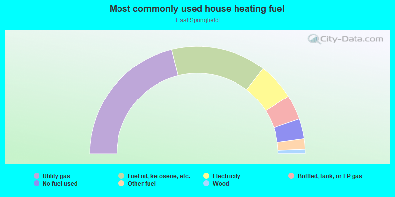
- 42.2%Utility gas
- 28.5%Fuel oil, kerosene, etc.
- 11.2%Electricity
- 7.4%Bottled, tank, or LP gas
- 6.1%No fuel used
- 3.1%Other fuel
- 1.3%Wood
Limited-access highways (interstate or state) in this neighborhood:
I- 291 (US Hwy 20)
Length: 4.27 miles
Directions: E-W, N-S, SW-NE
Directions: E-W, N-S, SW-NE
Highways in this neighborhood:
St James Blvd (State Hwy 20A)
Length: 0.40 miles
Direction: SW-NE
Address range: 102 to 299
Direction: SW-NE
Address range: 102 to 299
Worcester St (State Hwy 141)
Length: 0.08 miles
Direction: E-W
Address range: 220 to 444
Direction: E-W
Address range: 220 to 444
Roads and streets:
Page Blvd
Length: 3.68 miles
Directions: E-W, N-S, SE-NW, SW-NE
Address range: 5 to 1481
Directions: E-W, N-S, SE-NW, SW-NE
Address range: 5 to 1481
Cottage St
Length: 1.86 miles
Directions: E-W, N-S, SE-NW, SW-NE
Address range: 1 to 650
Directions: E-W, N-S, SE-NW, SW-NE
Address range: 1 to 650
Osborne St
Length: 1.27 miles
Directions: E-W, N-S, SE-NW
Address range: 2 to 298
Directions: E-W, N-S, SE-NW
Address range: 2 to 298
Rocus St
Length: 1.24 miles
Directions: E-W, N-S, SW-NE
Address range: 1 to 420
Directions: E-W, N-S, SW-NE
Address range: 1 to 420
Roosevelt Ave
Length: 1.23 miles
Directions: E-W, N-S, SE-NW
Address range: 1903 to 2499
Directions: E-W, N-S, SE-NW
Address range: 1903 to 2499
Cadwell Dr
Length: 1.08 miles
Directions: E-W, N-S, SE-NW, SW-NE
Address range: 1 to 499
Directions: E-W, N-S, SE-NW, SW-NE
Address range: 1 to 499
Industry Ave
Length: 0.94 miles
Directions: E-W, N-S, SE-NW, SW-NE
Address range: 1 to 399
Directions: E-W, N-S, SE-NW, SW-NE
Address range: 1 to 399
Carew St
Length: 0.72 miles
Directions: N-S, SW-NE
Address range: 1377 to 1758
Directions: N-S, SW-NE
Address range: 1377 to 1758
East St
Length: 0.66 miles
Directions: N-S, SE-NW
Address range: 20 to 325
Directions: N-S, SE-NW
Address range: 20 to 325
Bowles Park
Length: 0.65 miles
Directions: E-W, N-S, SW-NE
Address range: 2 to 136
Directions: E-W, N-S, SW-NE
Address range: 2 to 136
Tremont St
Length: 0.62 miles
Directions: E-W, N-S, SW-NE
Address range: 1 to 399
Directions: E-W, N-S, SW-NE
Address range: 1 to 399
el Paso St
Length: 0.61 miles
Directions: N-S, SE-NW
Address range: 1 to 499
Directions: N-S, SE-NW
Address range: 1 to 499
Redlands St
Length: 0.57 miles
Direction: N-S
Address range: 1 to 299
Direction: N-S
Address range: 1 to 299
Arthur St
Length: 0.55 miles
Directions: E-W, N-S, SE-NW
Address range: 1 to 299
Directions: E-W, N-S, SE-NW
Address range: 1 to 299
Windemere St
Length: 0.55 miles
Directions: E-W, SE-NW
Address range: 1 to 299
Directions: E-W, SE-NW
Address range: 1 to 299
Memorial Dr
Length: 0.54 miles
Direction: E-W
Address range: 2 to 299
Direction: E-W
Address range: 2 to 299
Lang St
Length: 0.52 miles
Direction: E-W
Address range: 1 to 199
Direction: E-W
Address range: 1 to 199
Carando Dr
Length: 0.50 miles
Directions: E-W, N-S, SW-NE
Address range: 1 to 299
Directions: E-W, N-S, SW-NE
Address range: 1 to 299
Davis St
Length: 0.49 miles
Directions: E-W, SE-NW
Address range: 1 to 225
Directions: E-W, SE-NW
Address range: 1 to 225
Russell St
Length: 0.48 miles
Direction: SE-NW
Address range: 1 to 249
Direction: SE-NW
Address range: 1 to 249
Paramount St
Length: 0.41 miles
Directions: E-W, SW-NE
Address range: 1 to 199
Directions: E-W, SW-NE
Address range: 1 to 199
Prentice St
Length: 0.40 miles
Directions: E-W, N-S, SE-NW, SW-NE
Address range: 1 to 153
Directions: E-W, N-S, SE-NW, SW-NE
Address range: 1 to 153
Monrovia St
Length: 0.40 miles
Direction: N-S
Address range: 1 to 299
Direction: N-S
Address range: 1 to 299
Santa Barbara St
Length: 0.39 miles
Direction: N-S
Address range: 1 to 249
Direction: N-S
Address range: 1 to 249
Haumont Ter
Length: 0.38 miles
Direction: N-S
Direction: N-S
Edendale St
Length: 0.37 miles
Directions: E-W, N-S, SE-NW, SW-NE
Address range: 1 to 155
Directions: E-W, N-S, SE-NW, SW-NE
Address range: 1 to 155
W Canton Cir
Length: 0.37 miles
Directions: E-W, N-S, SE-NW, SW-NE
Address range: 1 to 175
Directions: E-W, N-S, SE-NW, SW-NE
Address range: 1 to 175
Putnam Cir
Length: 0.34 miles
Directions: E-W, N-S, SW-NE
Address range: 1 to 199
Directions: E-W, N-S, SW-NE
Address range: 1 to 199
Progress Ave
Length: 0.34 miles
Direction: N-S
Address range: 1 to 199
Direction: N-S
Address range: 1 to 199
Bowles Park Exd
Length: 0.34 miles
Directions: N-S, SW-NE
Address range: 138 to 299
Directions: N-S, SW-NE
Address range: 138 to 299
Bircham St
Length: 0.33 miles
Directions: E-W, SE-NW
Address range: 2 to 89
Directions: E-W, SE-NW
Address range: 2 to 89
Linnell St
Length: 0.33 miles
Direction: SW-NE
Address range: 1 to 199
Direction: SW-NE
Address range: 1 to 199
Ardmore St
Length: 0.32 miles
Direction: SE-NW
Address range: 1 to 199
Direction: SE-NW
Address range: 1 to 199
University St
Length: 0.32 miles
Direction: N-S
Address range: 1 to 173
Direction: N-S
Address range: 1 to 173
Oklahoma St
Length: 0.32 miles
Direction: E-W
Address range: 62 to 199
Direction: E-W
Address range: 62 to 199
Price St
Length: 0.30 miles
Directions: N-S, SE-NW, SW-NE
Address range: 1 to 199
Directions: N-S, SE-NW, SW-NE
Address range: 1 to 199
Curve St
Length: 0.28 miles
Directions: E-W, SE-NW
Address range: 1 to 99
Directions: E-W, SE-NW
Address range: 1 to 99
2nd St
Length: 0.27 miles
Directions: N-S, SE-NW
Address range: 1 to 199
Directions: N-S, SE-NW
Address range: 1 to 199
Jenness St
Length: 0.27 miles
Direction: SE-NW
Address range: 1 to 199
Direction: SE-NW
Address range: 1 to 199
Stevens St
Length: 0.27 miles
Directions: E-W, N-S, SE-NW
Address range: 1 to 150
Directions: E-W, N-S, SE-NW
Address range: 1 to 150
Fernwold St
Length: 0.26 miles
Directions: E-W, SW-NE
Address range: 1 to 150
Directions: E-W, SW-NE
Address range: 1 to 150
Stanley St
Length: 0.25 miles
Directions: E-W, N-S
Address range: 1 to 99
Directions: E-W, N-S
Address range: 1 to 99
Brookdale Dr
Length: 0.24 miles
Directions: N-S, SE-NW
Address range: 1 to 70
Directions: N-S, SE-NW
Address range: 1 to 70
Notre Dame St
Length: 0.24 miles
Direction: E-W
Address range: 1 to 99
Direction: E-W
Address range: 1 to 99
Oakdale St
Length: 0.23 miles
Direction: SE-NW
Address range: 1 to 199
Direction: SE-NW
Address range: 1 to 199
Guion St
Length: 0.23 miles
Directions: E-W, SW-NE
Address range: 1 to 99
Directions: E-W, SW-NE
Address range: 1 to 99
Robbins Rd
Length: 0.23 miles
Directions: N-S, SE-NW
Address range: 1 to 99
Directions: N-S, SE-NW
Address range: 1 to 99
St James Cir
Length: 0.23 miles
Directions: N-S, SE-NW, SW-NE
Address range: 1 to 125
Directions: N-S, SE-NW, SW-NE
Address range: 1 to 125
Jean Dr
Length: 0.22 miles
Direction: E-W
Address range: 1 to 99
Direction: E-W
Address range: 1 to 99
Kenway Dr
Length: 0.22 miles
Direction: E-W
Address range: 1 to 99
Direction: E-W
Address range: 1 to 99
Farragut St
Length: 0.22 miles
Directions: E-W, SE-NW, SW-NE
Address range: 1 to 99
Directions: E-W, SE-NW, SW-NE
Address range: 1 to 99
Watling St
Length: 0.22 miles
Directions: E-W, SW-NE
Address range: 1 to 99
Directions: E-W, SW-NE
Address range: 1 to 99
Bessemer St
Length: 0.21 miles
Directions: N-S, SW-NE
Address range: 1 to 99
Directions: N-S, SW-NE
Address range: 1 to 99
Duryea St
Length: 0.21 miles
Direction: N-S
Address range: 1 to 199
Direction: N-S
Address range: 1 to 199
Fresno St
Length: 0.21 miles
Direction: N-S
Address range: 1 to 199
Direction: N-S
Address range: 1 to 199
Pinta Cir
Length: 0.21 miles
Directions: E-W, N-S, SE-NW, SW-NE
Address range: 2 to 98
Directions: E-W, N-S, SE-NW, SW-NE
Address range: 2 to 98
Eureka St
Length: 0.19 miles
Directions: E-W, N-S, SW-NE
Address range: 1 to 99
Directions: E-W, N-S, SW-NE
Address range: 1 to 99
Anne St
Length: 0.19 miles
Direction: SE-NW
Address range: 1 to 99
Direction: SE-NW
Address range: 1 to 99
Corona St
Length: 0.18 miles
Directions: E-W, N-S, SE-NW
Address range: 152 to 299
Directions: E-W, N-S, SE-NW
Address range: 152 to 299
Beaufort Cir
Length: 0.17 miles
Directions: E-W, N-S, SE-NW, SW-NE
Address range: 1 to 99
Directions: E-W, N-S, SE-NW, SW-NE
Address range: 1 to 99
E Canton Cir
Length: 0.17 miles
Directions: E-W, N-S, SE-NW, SW-NE
Address range: 1 to 99
Directions: E-W, N-S, SE-NW, SW-NE
Address range: 1 to 99
Atherton Ave
Length: 0.17 miles
Directions: E-W, SE-NW, SW-NE
Address range: 1 to 199
Directions: E-W, SE-NW, SW-NE
Address range: 1 to 199
Ames St
Length: 0.17 miles
Directions: E-W, SW-NE
Address range: 24 to 99
Directions: E-W, SW-NE
Address range: 24 to 99
Thornton St
Length: 0.16 miles
Direction: SE-NW
Address range: 1 to 99
Direction: SE-NW
Address range: 1 to 99
Fordham St
Length: 0.16 miles
Direction: N-S
Address range: 1 to 99
Direction: N-S
Address range: 1 to 99
Acme Pl
Length: 0.16 miles
Directions: N-S, SW-NE
Address range: 1 to 99
Directions: N-S, SW-NE
Address range: 1 to 99
Rose St
Length: 0.16 miles
Direction: SE-NW
Address range: 1 to 99
Direction: SE-NW
Address range: 1 to 99
Anniversary St
Length: 0.15 miles
Directions: E-W, SE-NW
Address range: 1 to 73
Directions: E-W, SE-NW
Address range: 1 to 73
Fitzgerald Rd
Length: 0.15 miles
Direction: SE-NW
Address range: 1 to 99
Direction: SE-NW
Address range: 1 to 99
Georgetown St
Length: 0.15 miles
Direction: N-S
Address range: 1 to 99
Direction: N-S
Address range: 1 to 99
Santa Maria St
Length: 0.15 miles
Directions: N-S, SW-NE
Address range: 1 to 99
Directions: N-S, SW-NE
Address range: 1 to 99
Ronald Dr
Length: 0.14 miles
Direction: N-S
Address range: 1 to 99
Direction: N-S
Address range: 1 to 99
Kulig St
Length: 0.14 miles
Direction: N-S
Address range: 1 to 99
Direction: N-S
Address range: 1 to 99
Canton St
Length: 0.14 miles
Direction: SW-NE
Address range: 55 to 199
Direction: SW-NE
Address range: 55 to 199
Bray St
Length: 0.13 miles
Directions: N-S, SE-NW
Address range: 1 to 75
Directions: N-S, SE-NW
Address range: 1 to 75
Baldwin St
Length: 0.13 miles
Directions: N-S, SW-NE
Address range: 1 to 99
Directions: N-S, SW-NE
Address range: 1 to 99
Birch St
Length: 0.13 miles
Direction: SE-NW
Address range: 1 to 49
Direction: SE-NW
Address range: 1 to 49
Holy Cross St
Length: 0.12 miles
Direction: N-S
Address range: 1 to 99
Direction: N-S
Address range: 1 to 99
Observer St
Length: 0.12 miles
Directions: E-W, SE-NW, SW-NE
Address range: 1 to 71
Directions: E-W, SE-NW, SW-NE
Address range: 1 to 71
Turnbull St
Length: 0.12 miles
Directions: N-S, SE-NW
Address range: 1 to 99
Directions: N-S, SE-NW
Address range: 1 to 99
Rio Vista St
Length: 0.11 miles
Direction: SW-NE
Address range: 1 to 99
Direction: SW-NE
Address range: 1 to 99
French St
Length: 0.11 miles
Directions: E-W, SW-NE
Address range: 1 to 99
Directions: E-W, SW-NE
Address range: 1 to 99
Jimmy Ct
Length: 0.11 miles
Direction: E-W
Address range: 1 to 99
Direction: E-W
Address range: 1 to 99
End St
Length: 0.10 miles
Direction: SW-NE
Address range: 1 to 50
Direction: SW-NE
Address range: 1 to 50
Sargon St
Length: 0.10 miles
Directions: N-S, SE-NW
Address range: 1 to 99
Directions: N-S, SE-NW
Address range: 1 to 99
Marquette St
Length: 0.10 miles
Direction: N-S
Address range: 1 to 99
Direction: N-S
Address range: 1 to 99
Carlos St
Length: 0.10 miles
Direction: SE-NW
Address range: 1 to 99
Direction: SE-NW
Address range: 1 to 99
Gladsworth St
Length: 0.10 miles
Direction: E-W
Address range: 1 to 49
Direction: E-W
Address range: 1 to 49
Rathbun St
Length: 0.10 miles
Directions: N-S, SW-NE
Address range: 1 to 99
Directions: N-S, SW-NE
Address range: 1 to 99
Hendee St
Length: 0.10 miles
Direction: SE-NW
Address range: 1 to 699
Direction: SE-NW
Address range: 1 to 699
Decker Pl
Length: 0.09 miles
Directions: E-W, SE-NW
Address range: 1 to 99
Directions: E-W, SE-NW
Address range: 1 to 99
Cameron St
Length: 0.09 miles
Directions: N-S, SW-NE
Address range: 1 to 99
Directions: N-S, SW-NE
Address range: 1 to 99
Hobart St
Length: 0.09 miles
Direction: E-W
Address range: 16 to 99
Direction: E-W
Address range: 16 to 99
Glen Albyn St
Length: 0.09 miles
Directions: E-W, SW-NE
Address range: 1 to 81
Directions: E-W, SW-NE
Address range: 1 to 81
Beaven St
Length: 0.08 miles
Direction: E-W
Address range: 1 to 99
Direction: E-W
Address range: 1 to 99
Lyn St
Length: 0.08 miles
Directions: N-S, SE-NW, SW-NE
Address range: 1 to 99
Directions: N-S, SE-NW, SW-NE
Address range: 1 to 99
Rose Pl
Length: 0.07 miles
Direction: SW-NE
Address range: 1 to 99
Direction: SW-NE
Address range: 1 to 99
Caldwell Pl
Length: 0.07 miles
Direction: SE-NW
Address range: 1 to 99
Direction: SE-NW
Address range: 1 to 99
Shaws Ln
Length: 0.07 miles
Direction: SE-NW
Address range: 1 to 199
Direction: SE-NW
Address range: 1 to 199
Campechi St
Length: 0.07 miles
Direction: E-W
Address range: 88 to 99
Direction: E-W
Address range: 88 to 99
Spence St
Length: 0.07 miles
Directions: E-W, SE-NW
Address range: 2 to 99
Directions: E-W, SE-NW
Address range: 2 to 99
Ivan St
Length: 0.06 miles
Direction: N-S
Address range: 1 to 99
Direction: N-S
Address range: 1 to 99
Mona St
Length: 0.06 miles
Direction: SW-NE
Address range: 1 to 99
Direction: SW-NE
Address range: 1 to 99
Kelly Pl
Length: 0.06 miles
Direction: SE-NW
Address range: 1 to 99
Direction: SE-NW
Address range: 1 to 99
1st St
Length: 0.05 miles
Direction: SE-NW
Direction: SE-NW
St James Ave
Length: 0.05 miles
Direction: SE-NW
Address range: 1158 to 1183
Direction: SE-NW
Address range: 1158 to 1183
Akron Pl
Length: 0.04 miles
Direction: N-S
Address range: 1 to 99
Direction: N-S
Address range: 1 to 99
Little John St
Length: 0.04 miles
Direction: N-S
Direction: N-S
Railroad features:
Penn Central RR
Length: 5.46 miles
Directions: E-W, N-S, SW-NE
Directions: E-W, N-S, SW-NE
Penn Central RR Yard
Length: 1.48 miles
Directions: N-S, SW-NE
Directions: N-S, SW-NE
Penn Central RR Spur
Length: 0.58 miles
Directions: E-W, N-S, SW-NE
Directions: E-W, N-S, SW-NE