Ford Prairie (Fords Prairie) neighborhood in Centralia, Washington (WA), 98531 detailed profile
Settings
X


Business Search - 14 Million verified businesses
Area: 7.889 square miles
Population: 6,692
Population density:
| Ford Prairie (Fords Prairie): | 848 people per square mile |
| Centralia: | 2,462 people per square mile |

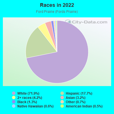
- 5,02271.9%White
- 1,23517.7%Hispanic or Latino
- 2924.2%Two or more races
- 2213.2%Asian
- 921.3%Black
- 470.7%Some other race
- 420.6%Native Hawaiian and Other
Pacific Islander - 330.5%American Indian
Median household income in 2022:
| Ford Prairie (Fords Prairie): | $65,341 |
| Centralia: | $50,422 |
Distribution of median household income
![Distribution of median household income]()
- 216Less than $10,000
- 425$10,000 to $19,999
- 338$20,000 to $29,999
- 218$30,000 to $39,999
- 270$40,000 to $49,999
- 342$50,000 to $59,999
- 126$60,000 to $74,999
- 467$75,000 to $99,999
- 251$100,000 to $124,999
- 193$125,000 to $149,999
- 150$150,000 to $199,999
- 183$200,000 or more

Distribution of owner-occupied house/condo value
![Distribution of owner-occupied house/condo value]()
- 1,483Less than $50,000
- 694$50,000 to $99,999
- 1,022$100,000 to $149,999
- 200$150,000 to $199,999
- 258$200,000 to $249,999
- 290$250,000 to $299,999
- 355$300,000 to $399,999
- 179$400,000 to $499,999
- 125$500,000 to $749,999
- 16$750,000 to $999,999
- 34$1,000,000 or more

Distribution of rent paid by renters
![Distribution of rent paid by renters]()
- 46Less than $100
- 180$100 to $199
- 301$200 to $299
- 282$300 to $399
- 191$400 to $499
- 24$500 to $599
- 486$600 to $699
- 314$700 to $799
- 207$800 to $899
- 188$900 to $999
- 278$1,000 to $1,249
- 1,277$1,250 to $1,499
- 35$1,500 to $1,999
- 311$2,000 or more

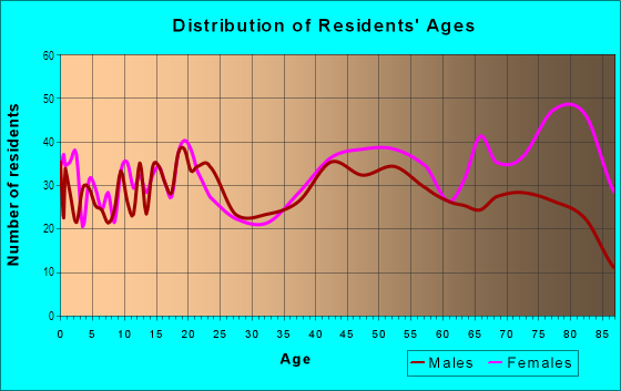
| Males: | 3,147 |
| Females: | 3,544 |
Males:
| This neighborhood: | 39.2 years |
| Whole city: | 35.4 years |
| This neighborhood: | 47.4 years |
| Whole city: | 42.2 years |
Average household size:
| Ford Prairie (Fords Prairie): | 4.5 people |
| Centralia: | 2.4 people |
Percentage of family households:
| Ford Prairie (Fords Prairie): | 42.2% |
| Centralia: | 37.4% |
| Here: | 35.5% |
| Centralia: | 31.1% |
Percentage of married-couple families with children (among all households):
| Ford Prairie (Fords Prairie): | 23.4% |
| Centralia: | 21.0% |
Percentage of single-mother households (among all households):
| Ford Prairie (Fords Prairie): | 6.7% |
| Centralia: | 12.7% |
Percentage of never married males 15 years old and over:
Percentage of never married females 15 years old and over:
| Ford Prairie (Fords Prairie): | 15.7% |
| Centralia: | 18.1% |
Percentage of never married females 15 years old and over:
| Ford Prairie (Fords Prairie): | 12.5% |
| city: | 14.5% |
Percentage of people that speak English not well or not at all:
| Ford Prairie (Fords Prairie): | 3.0% |
| Centralia: | 2.8% |
Percentage of people born in this state:
Percentage of people born in another U.S. state:
Percentage of native residents but born outside the U.S.:
Percentage of foreign born residents:
| Here: | 63.3% |
| Centralia: | 58.6% |
Percentage of people born in another U.S. state:
| Ford Prairie (Fords Prairie): | 29.1% |
| Centralia: | 33.3% |
Percentage of native residents but born outside the U.S.:
| Here: | 0.3% |
| city: | 0.8% |
Percentage of foreign born residents:
| Here: | 7.4% |
| Centralia: | 7.3% |
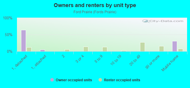
Owner-occupied
Renter-occupied

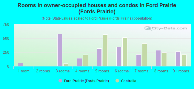
- Rooms in owner-occupied houses and condos in Ford Prairie <
> - 561 room
- 62 rooms
- 5793 rooms
- 1444 rooms
- 3215 rooms
- 3456 rooms
- 2137 rooms
- 2888 rooms
- 2669+ rooms

- Rooms in renter-occupied apartments in Ford Prairie <
> - 2001 room
- 792 rooms
- 3503 rooms
- 3404 rooms
- 1415 rooms
- 1046 rooms
- 1997 rooms
- 4468 rooms
- 429+ rooms
Owner-occupied
Renter-occupied
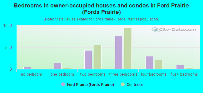
- Bedrooms in owner-occupied houses and condos in Ford Prairie <
> - 56no bedroom
- 1461 bedroom
- 4302 bedrooms
- 7693 bedrooms
- 2994 bedrooms
- 995+ bedrooms
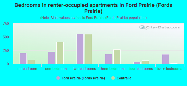
- Bedrooms in renter-occupied apartments in Ford Prairie <
> - 200no bedroom
- 2281 bedroom
- 5592 bedrooms
- 1843 bedrooms
- 404 bedrooms
- 1815+ bedrooms
Average number of cars or other vehicles available in houses/condos:
Average number of cars or other vehicles available in apartments:
| This neighborhood: | 2.8 |
| Centralia: | 2.1 |
Average number of cars or other vehicles available in apartments:
| Here: | 1.9 |
| city: | 1.4 |
Percentage of units with a mortgage:
| Ford Prairie (Fords Prairie): | 58.3% |
| Centralia: | 60.6% |
Housing prices:
- Average estimated value of detached houses in 2022 (50.2% of all units):
Ford Prairie (Fords Prairie): $311,023 Washington: $734,307
- Average estimated value of mobile home in 2022 (24.1% of all units):
Ford Prairie (Fords Prairie): $98,067 Washington: $218,362
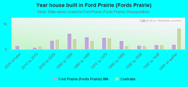
- Year house built in Ford Prairie <
> - 1442020 or later
- 832010 to 2019
- 3572000 to 2009
- 6291990 to 1999
- 4971980 to 1989
- 4761970 to 1979
- 3431960 to 1969
- 1621950 to 1959
- 1831940 to 1949
- 1941939 or earlier
City-data.com crime index for city in 2020 (higher means more crime):
| City: | 257.3 |
| U.S. average: | 219.5 |
Travel time to work (commute)
![Travel time to work (commute)]()
- 293Less than 5 minutes
- 5105 to 9 minutes
- 44610 to 14 minutes
- 49615 to 19 minutes
- 32020 to 24 minutes
- 7525 to 29 minutes
- 20330 to 34 minutes
- 13635 to 39 minutes
- 3040 to 44 minutes
- 17245 to 59 minutes
- 5760 to 89 minutes
- 11990 or more minutes

Means of transportation to work
![Means of transportation to work]()
- 73.5%1,998Drove a car alone
- 17.3%469Carpooled
- 6.9%188Bus
- 1.6%43Motorcycle
- 3.5%94Bicycle
- 8.5%232Walked
- 12.6%342Other means
- 5.4%146Worked at home

Time leaving home to go to work
![Time leaving home to go to work]()
- 9612:00 a.m. to 4:59 a.m.
- 2285:00 a.m. to 5:29 a.m.
- 415:30 a.m. to 5:59 a.m.
- 3846:00 a.m. to 6:29 a.m.
- 3066:30 a.m. to 6:59 a.m.
- 2687:00 a.m. to 7:29 a.m.
- 4617:30 a.m. to 7:59 a.m.
- 1888:00 a.m. to 8:29 a.m.
- 1898:30 a.m. to 8:59 a.m.
- 69:00 a.m. to 9:59 a.m.
- 1910:00 a.m. to 10:59 a.m.
- 7911:00 a.m. to 11:59 a.m.
- 31412:00 p.m. to 3:59 p.m.
- 3074:00 p.m. to 11:59 p.m.

Occupations of males:
- Percentage of males in management occupations (except farmers):
Here: 5.5% city: 5.2%
- Percentage of males in business and financial operations occupations:
Here: 7.7% city: 6.2%
- Percentage of males in computer and mathematical occupations:
Here: 4.3% city: 3.2%
- Percentage of males in education, training, and library occupations:
Here: 5.5% city: 2.9%
- Percentage of males in service occupations:
Here: 12.7% city: 15.4%
- Percentage of males in sales and office occupations:
Here: 21.9% city: 12.8%
- Percentage of males in farming, fishing, and forestry occupations:
Here: 5.0% city: 3.7%
- Percentage of males in construction, extraction, and maintenance occupations:
Here: 13.0% city: 17.1%
- Percentage of males in production occupations:
Here: 6.9% city: 9.8%
- Percentage of males in transportation occupations:
Here: 3.4% city: 5.0%
- Percentage of males in material moving occupations:
Here: 2.2% city: 6.3%
Occupations of females:
- Percentage of females in business and financial operations occupations:
Here: 2.6% city: 5.3%
- Percentage of females in education, training, and library occupations:
Here: 5.7% city: 3.9%
- Percentage of females in arts, design, entertainment, sports, and media occupations:
Here: 4.3% city: 4.4%
- Percentage of females in healthcare practitioners and technical occupations:
Here: 12.7% city: 8.9%
- Percentage of females in service occupations:
Here: 37.1% city: 33.4%
- Percentage of females in sales and office occupations:
Here: 33.8% city: 23.9%
- Percentage of females in transportation occupations:
Here: 1.6% city: 1.9%
Percentage of people 16-64 in Armed Forces:
| Ford Prairie (Fords Prairie): | 0.1% |
| Centralia: | 0.3% |
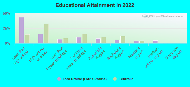
Education in this neighborhood (subdivision or community):
- Percentage of people 3 years and older in K-12 schools:
Ford Prairie (Fords Prairie): 25.1% Centralia: 15.2%
- Percentage of people 3 years and older in undergraduate colleges:
Ford Prairie (Fords Prairie): 5.9% Centralia: 4.3%
- Percentage of people 3 years and older in grad. or professional schools:
Ford Prairie (Fords Prairie): 0.9% Centralia: 0.5%
- Percentage of students K-12 enrolled in private schools:
Ford Prairie (Fords Prairie): 30.2% Centralia: 5.6%
Percentage of population below poverty level:
| Ford Prairie (Fords Prairie): | 22.0% |
| Centralia: | 21.6% |
Median year owner moved in (as recorded in 2022):
| Ford Prairie (Fords Prairie): | 2010 |
| Centralia: | 2012 |
Percentage of married-couple families with both working:
| Ford Prairie (Fords Prairie): | 100.6% |
| Centralia: | 66.6% |
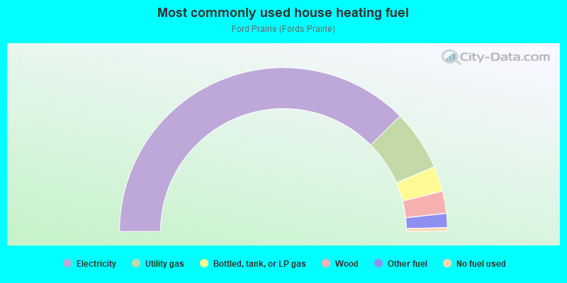
- 75.2%Electricity
- 12.0%Utility gas
- 5.0%Bottled, tank, or LP gas
- 4.4%Wood
- 2.8%Other fuel
- 0.7%No fuel used
Limited-access highways (interstate or state) in this neighborhood:
I- 5 (US Hwy 12)
Length: 8.96 miles
Directions: N-S, SE-NW
Directions: N-S, SE-NW
Roads and streets:
Harrison Ave
Length: 3.23 miles
Directions: E-W, N-S, SE-NW
Address range: 986 to 3909
Directions: E-W, N-S, SE-NW
Address range: 986 to 3909
Cooks Hill Rd
Length: 2.48 miles
Directions: E-W, N-S, SE-NW
Address range: 1500 to 3499
Directions: E-W, N-S, SE-NW
Address range: 1500 to 3499
Galvin Rd
Length: 2.13 miles
Direction: E-W
Address range: 2900 to 4340
Direction: E-W
Address range: 2900 to 4340
Borst Ave
Length: 1.49 miles
Direction: E-W
Address range: 2016 to 3398
Direction: E-W
Address range: 2016 to 3398
Fords Prairie Ave
Length: 1.36 miles
Direction: E-W
Address range: 2400 to 3521
Direction: E-W
Address range: 2400 to 3521
Russell Rd
Length: 1.34 miles
Direction: E-W
Address range: 2803 to 3898
Direction: E-W
Address range: 2803 to 3898
S Scheuber Rd
Length: 1.23 miles
Directions: E-W, N-S, SW-NE
Address range: 800 to 1526
Directions: E-W, N-S, SW-NE
Address range: 800 to 1526
Graf Rd
Length: 1.14 miles
Directions: E-W, SW-NE
Address range: 2100 to 2911
Directions: E-W, SW-NE
Address range: 2100 to 2911
Foron Rd
Length: 1.10 miles
Direction: N-S
Address range: 2000 to 3217
Direction: N-S
Address range: 2000 to 3217
Sandra Ave
Length: 1.04 miles
Direction: N-S
Address range: 2100 to 2999
Direction: N-S
Address range: 2100 to 2999
Mount Vista Rd
Length: 1.03 miles
Direction: E-W
Address range: 2500 to 3499
Direction: E-W
Address range: 2500 to 3499
W Reynolds Ave
Length: 1.03 miles
Directions: E-W, SE-NW, SW-NE
Address range: 1734 to 2899
Directions: E-W, SE-NW, SW-NE
Address range: 1734 to 2899
Blanchard Rd
Length: 1.00 miles
Directions: E-W, SE-NW, SW-NE
Address range: 269 to 405
Directions: E-W, SE-NW, SW-NE
Address range: 269 to 405
Ives Rd
Length: 0.95 miles
Direction: E-W
Address range: 3100 to 3729
Direction: E-W
Address range: 3100 to 3729
Military Rd
Length: 0.72 miles
Directions: E-W, N-S, SW-NE
Address range: 1600 to 1899
Directions: E-W, N-S, SW-NE
Address range: 1600 to 1899
Eshom Rd
Length: 0.71 miles
Direction: N-S
Address range: 800 to 1699
Direction: N-S
Address range: 800 to 1699
Scheuber Rd N
Length: 0.71 miles
Direction: N-S
Address range: 800 to 1308
Direction: N-S
Address range: 800 to 1308
Johnson Rd
Length: 0.70 miles
Direction: N-S
Address range: 900 to 1699
Direction: N-S
Address range: 900 to 1699
Goodrich Rd
Length: 0.70 miles
Directions: E-W, N-S, SE-NW
Address range: 100 to 599
Directions: E-W, N-S, SE-NW
Address range: 100 to 599
Taylor St
Length: 0.63 miles
Direction: N-S
Address range: 1700 to 2399
Direction: N-S
Address range: 1700 to 2399
Van Wormer St
Length: 0.63 miles
Direction: N-S
Address range: 1700 to 2399
Direction: N-S
Address range: 1700 to 2399
Summerside Dr
Length: 0.63 miles
Directions: E-W, N-S, SE-NW, SW-NE
Address range: 100 to 299
Directions: E-W, N-S, SE-NW, SW-NE
Address range: 100 to 299
Belmont Ave
Length: 0.55 miles
Direction: N-S
Address range: 1000 to 1520
Direction: N-S
Address range: 1000 to 1520
Scammon Creek Rd
Length: 0.55 miles
Directions: N-S, SW-NE
Address range: 901 to 1399
Directions: N-S, SW-NE
Address range: 901 to 1399
Gallagher Rd
Length: 0.51 miles
Directions: E-W, N-S, SW-NE
Address range: 1700 to 2299
Directions: E-W, N-S, SW-NE
Address range: 1700 to 2299
Bennett Rd
Length: 0.51 miles
Direction: E-W
Address range: 2600 to 3099
Direction: E-W
Address range: 2600 to 3099
Mellen St
Length: 0.48 miles
Directions: E-W, SE-NW
Address range: 1364 to 1799
Directions: E-W, SE-NW
Address range: 1364 to 1799
Mayberry Rd
Length: 0.47 miles
Direction: E-W
Address range: 3500 to 3822
Direction: E-W
Address range: 3500 to 3822
View Ave
Length: 0.44 miles
Direction: N-S
Address range: 1100 to 1699
Direction: N-S
Address range: 1100 to 1699
Airport Rd
Length: 0.43 miles
Directions: N-S, SE-NW
Address range: 900 to 1099
Directions: N-S, SE-NW
Address range: 900 to 1099
Colonial Dr
Length: 0.43 miles
Direction: E-W
Address range: 2400 to 2799
Direction: E-W
Address range: 2400 to 2799
Blair Rd
Length: 0.42 miles
Directions: N-S, SE-NW, SW-NE
Address range: 2320 to 2322
Directions: N-S, SE-NW, SW-NE
Address range: 2320 to 2322
Lum Rd
Length: 0.39 miles
Directions: N-S, SE-NW
Address range: 1200 to 1799
Directions: N-S, SE-NW
Address range: 1200 to 1799
Bryden Ave
Length: 0.38 miles
Direction: N-S
Address range: 129 to 621
Direction: N-S
Address range: 129 to 621
Oakland Ave
Length: 0.38 miles
Direction: N-S
Address range: 200 to 799
Direction: N-S
Address range: 200 to 799
Industrial Dr
Length: 0.36 miles
Directions: E-W, N-S, SE-NW
Directions: E-W, N-S, SE-NW
Sunnyside Dr
Length: 0.35 miles
Directions: E-W, N-S, SE-NW
Address range: 100 to 144
Directions: E-W, N-S, SE-NW
Address range: 100 to 144
Jalyn St
Length: 0.34 miles
Direction: E-W
Address range: 100 to 140
Direction: E-W
Address range: 100 to 140
Caveness Dr
Length: 0.34 miles
Direction: SE-NW
Address range: 1001 to 1199
Direction: SE-NW
Address range: 1001 to 1199
Robert Frost Dr (R Frost Dr)
Length: 0.32 miles
Directions: E-W, SE-NW
Address range: 100 to 1299
Directions: E-W, SE-NW
Address range: 100 to 1299
Searle Dr
Length: 0.31 miles
Directions: E-W, N-S, SE-NW, SW-NE
Address range: 1200 to 1279
Directions: E-W, N-S, SE-NW, SW-NE
Address range: 1200 to 1279
Stedhammer Dr
Length: 0.30 miles
Directions: E-W, N-S, SW-NE
Directions: E-W, N-S, SW-NE
Earl St
Length: 0.29 miles
Direction: E-W
Address range: 2000 to 2208
Direction: E-W
Address range: 2000 to 2208
Nick Rd
Length: 0.29 miles
Direction: N-S
Address range: 300 to 699
Direction: N-S
Address range: 300 to 699
Prairie Ave
Length: 0.29 miles
Direction: E-W
Address range: 3700 to 3899
Direction: E-W
Address range: 3700 to 3899
Shamrock Dr
Length: 0.29 miles
Direction: E-W
Address range: 1700 to 1999
Direction: E-W
Address range: 1700 to 1999
Spring Ln
Length: 0.28 miles
Directions: N-S, SE-NW
Address range: 800 to 1099
Directions: N-S, SE-NW
Address range: 800 to 1099
Lebarin Ln
Length: 0.28 miles
Directions: E-W, N-S, SW-NE
Address range: 100 to 304
Directions: E-W, N-S, SW-NE
Address range: 100 to 304
Carmen Ln
Length: 0.25 miles
Directions: E-W, N-S, SW-NE
Address range: 100 to 199
Directions: E-W, N-S, SW-NE
Address range: 100 to 199
Fieldcrest Ave
Length: 0.23 miles
Direction: N-S
Address range: 1100 to 1398
Direction: N-S
Address range: 1100 to 1398
9th St
Length: 0.23 miles
Direction: E-W
Address range: 2000 to 2204
Direction: E-W
Address range: 2000 to 2204
Allen Ave
Length: 0.22 miles
Directions: N-S, SW-NE
Address range: 700 to 919
Directions: N-S, SW-NE
Address range: 700 to 919
Swanson Dr
Length: 0.21 miles
Directions: E-W, N-S, SW-NE
Address range: 800 to 1099
Directions: E-W, N-S, SW-NE
Address range: 800 to 1099
Jensen Ave
Length: 0.21 miles
Direction: N-S
Address range: 1400 to 1699
Direction: N-S
Address range: 1400 to 1699
Haviland St
Length: 0.21 miles
Direction: E-W
Address range: 2094 to 2198
Direction: E-W
Address range: 2094 to 2198
Landing Way
Length: 0.21 miles
Directions: E-W, N-S, SE-NW, SW-NE
Address range: 800 to 999
Directions: E-W, N-S, SE-NW, SW-NE
Address range: 800 to 999
Horsley Ave
Length: 0.20 miles
Direction: E-W
Address range: 3100 to 3299
Direction: E-W
Address range: 3100 to 3299
Washington Way
Length: 0.20 miles
Direction: N-S
Address range: 100 to 298
Direction: N-S
Address range: 100 to 298
Sharon St
Length: 0.19 miles
Directions: E-W, N-S, SE-NW
Address range: 2500 to 2539
Directions: E-W, N-S, SE-NW
Address range: 2500 to 2539
Cedar Ridge Dr
Length: 0.19 miles
Directions: E-W, SE-NW
Address range: 100 to 199
Directions: E-W, SE-NW
Address range: 100 to 199
Providence Ln
Length: 0.19 miles
Directions: E-W, N-S, SW-NE
Address range: 1700 to 1799
Directions: E-W, N-S, SW-NE
Address range: 1700 to 1799
Stillwaters Ave
Length: 0.18 miles
Direction: N-S
Address range: 1100 to 1299
Direction: N-S
Address range: 1100 to 1299
Lemar Ln
Length: 0.17 miles
Direction: N-S
Address range: 1900 to 2299
Direction: N-S
Address range: 1900 to 2299
Southgate Dr
Length: 0.17 miles
Direction: E-W
Address range: 3000 to 3019
Direction: E-W
Address range: 3000 to 3019
Alcott Dr
Length: 0.16 miles
Directions: E-W, SE-NW
Address range: 100 to 299
Directions: E-W, SE-NW
Address range: 100 to 299
William Faulkner Dr
Length: 0.16 miles
Directions: E-W, N-S, SE-NW
Address range: 100 to 199
Directions: E-W, N-S, SE-NW
Address range: 100 to 199
N Bennett Rd
Length: 0.16 miles
Direction: N-S
Direction: N-S
Edgewood Ln
Length: 0.16 miles
Direction: E-W
Address range: 3300 to 3342
Direction: E-W
Address range: 3300 to 3342
Travera Pl
Length: 0.16 miles
Directions: E-W, N-S, SW-NE
Address range: 3400 to 3436
Directions: E-W, N-S, SW-NE
Address range: 3400 to 3436
Hoss Rd
Length: 0.16 miles
Direction: E-W
Address range: 100 to 299
Direction: E-W
Address range: 100 to 299
Kayu Ln
Length: 0.16 miles
Direction: N-S
Address range: 1291 to 1316
Direction: N-S
Address range: 1291 to 1316
Mahoney Dr
Length: 0.15 miles
Direction: N-S
Direction: N-S
Margaret Meadows Dr
Length: 0.15 miles
Directions: E-W, SE-NW
Directions: E-W, SE-NW
Rancho Rd
Length: 0.15 miles
Direction: N-S
Address range: 1100 to 1216
Direction: N-S
Address range: 1100 to 1216
Prill Rd
Length: 0.15 miles
Direction: E-W
Address range: 3300 to 3424
Direction: E-W
Address range: 3300 to 3424
Alberta Dr
Length: 0.14 miles
Direction: E-W
Address range: 3100 to 3213
Direction: E-W
Address range: 3100 to 3213
Bailey Rd (Bailey Ave)
Length: 0.14 miles
Direction: E-W
Address range: 3100 to 3211
Direction: E-W
Address range: 3100 to 3211
Laurel Ln
Length: 0.14 miles
Direction: E-W
Address range: 3100 to 3213
Direction: E-W
Address range: 3100 to 3213
Cowlitz Rd
Length: 0.13 miles
Direction: N-S
Address range: 800 to 916
Direction: N-S
Address range: 800 to 916
Pheasant Rd
Length: 0.13 miles
Direction: N-S
Address range: 800 to 999
Direction: N-S
Address range: 800 to 999
Bengal Ct
Length: 0.13 miles
Direction: N-S
Address range: 600 to 719
Direction: N-S
Address range: 600 to 719
Eb Browning Dr
Length: 0.13 miles
Directions: E-W, N-S, SE-NW
Address range: 200 to 299
Directions: E-W, N-S, SE-NW
Address range: 200 to 299
Scott Dr
Length: 0.13 miles
Direction: N-S
Address range: 600 to 719
Direction: N-S
Address range: 600 to 719
Southworth Ct
Length: 0.13 miles
Direction: E-W
Direction: E-W
S A Tennyson Dr
Length: 0.13 miles
Directions: N-S, SE-NW
Address range: 1100 to 1230
Directions: N-S, SE-NW
Address range: 1100 to 1230
Emily Ln
Length: 0.13 miles
Directions: E-W, N-S, SE-NW
Address range: 3000 to 3099
Directions: E-W, N-S, SE-NW
Address range: 3000 to 3099
Linda Ln
Length: 0.13 miles
Direction: E-W
Address range: 300 to 399
Direction: E-W
Address range: 300 to 399
Carl Sandberg Dr
Length: 0.13 miles
Direction: E-W
Address range: 100 to 199
Direction: E-W
Address range: 100 to 199
Cobra Ln
Length: 0.13 miles
Directions: E-W, N-S, SW-NE
Address range: 1100 to 1199
Directions: E-W, N-S, SW-NE
Address range: 1100 to 1199
Rodcin Ave
Length: 0.12 miles
Direction: E-W
Address range: 3500 to 3519
Direction: E-W
Address range: 3500 to 3519
Tiger Ln
Length: 0.12 miles
Direction: E-W
Address range: 3300 to 3499
Direction: E-W
Address range: 3300 to 3499
Yahtahay Ln
Length: 0.11 miles
Direction: E-W
Direction: E-W
Camre Ln
Length: 0.11 miles
Direction: N-S
Address range: 100 to 199
Direction: N-S
Address range: 100 to 199
Mason Ave
Length: 0.10 miles
Direction: N-S
Address range: 1100 to 1207
Direction: N-S
Address range: 1100 to 1207
Wayne Dr
Length: 0.10 miles
Direction: N-S
Address range: 800 to 833
Direction: N-S
Address range: 800 to 833
Sunrise Ln
Length: 0.10 miles
Direction: SE-NW
Address range: 800 to 999
Direction: SE-NW
Address range: 800 to 999
Greenwood Ln
Length: 0.10 miles
Direction: N-S
Address range: 1300 to 1318
Direction: N-S
Address range: 1300 to 1318
Melody Ct
Length: 0.09 miles
Direction: E-W
Address range: 3300 to 3599
Direction: E-W
Address range: 3300 to 3599
McKinley Ln N
Length: 0.08 miles
Directions: N-S, SE-NW
Directions: N-S, SE-NW
Hawthorne Ln
Length: 0.07 miles
Direction: E-W
Address range: 100 to 199
Direction: E-W
Address range: 100 to 199
Midway Ct
Length: 0.07 miles
Direction: N-S
Address range: 1700 to 1799
Direction: N-S
Address range: 1700 to 1799
Kristam Pl
Length: 0.07 miles
Direction: E-W
Address range: 3620 to 3645
Direction: E-W
Address range: 3620 to 3645
Stewart Pl
Length: 0.07 miles
Direction: E-W
Address range: 3616 to 3638
Direction: E-W
Address range: 3616 to 3638
Mardon Pl
Length: 0.07 miles
Direction: E-W
Address range: 3618 to 3640
Direction: E-W
Address range: 3618 to 3640
Karla Ct (Karla Rd)
Length: 0.06 miles
Direction: E-W
Address range: 3800 to 3811
Direction: E-W
Address range: 3800 to 3811
Kipling Ln
Length: 0.06 miles
Direction: E-W
Address range: 100 to 199
Direction: E-W
Address range: 100 to 199
Endeavor Dr
Length: 0.06 miles
Directions: E-W, N-S, SW-NE
Directions: E-W, N-S, SW-NE
Jalyn Ct
Length: 0.05 miles
Direction: N-S
Address range: 1288 to 1299
Direction: N-S
Address range: 1288 to 1299
Longfellow Ln
Length: 0.05 miles
Direction: E-W
Address range: 100 to 118
Direction: E-W
Address range: 100 to 118
Elizabeth Ct
Length: 0.05 miles
Direction: E-W
Direction: E-W
McKinley Ln W
Length: 0.05 miles
Directions: E-W, SE-NW
Directions: E-W, SE-NW
Cypress Ln
Length: 0.04 miles
Direction: N-S
Address range: 101 to 109
Direction: N-S
Address range: 101 to 109
Sandy Dr (Sandy Ln)
Length: 0.03 miles
Direction: N-S
Direction: N-S
Joyce Ln
Length: 0.03 miles
Direction: N-S
Address range: 1400 to 1499
Direction: N-S
Address range: 1400 to 1499
Railroad features:
Puget Sound and Pacific RR (Burlington Northern Santa Fe Rlwy)
Length: 2.61 miles
Directions: N-S, SE-NW
Directions: N-S, SE-NW
Tacoma Eastern RR
Length: 2.30 miles
Direction: SE-NW
Direction: SE-NW
Union Pacific RR
Length: 2.04 miles
Directions: E-W, SE-NW
Directions: E-W, SE-NW
Abandoned RR
Length: 0.20 miles
Direction: E-W
Direction: E-W
Other features:
Scammon Crk
Length: 2.21 miles
Directions: E-W, N-S, SE-NW, SW-NE
Directions: E-W, N-S, SE-NW, SW-NE
South Branch Scammon Crk
Length: 0.94 miles
Directions: E-W, N-S, SE-NW, SW-NE
Directions: E-W, N-S, SE-NW, SW-NE
China Crk
Length: 0.18 miles
Directions: E-W, SE-NW
Directions: E-W, SE-NW